Site blog
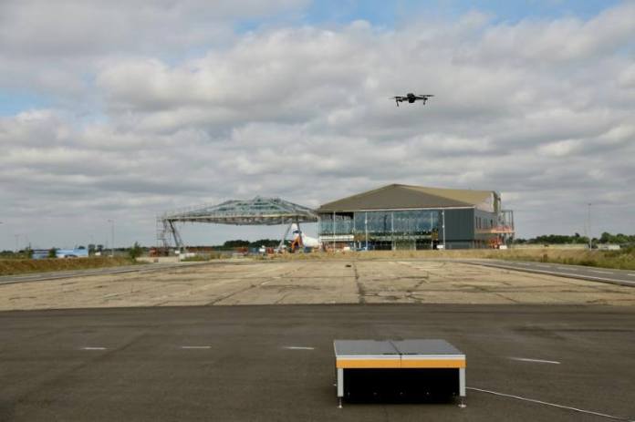
Unmanned aerial vehicles (UAVs) have been used to inspect the runway at Cranfield Airport remotely for the first time.
The flights make use of ‘drone-in-a-box’ technology with the aim of enabling routine inspections to take place with UAVs that can be automatically deployed, recovered and recharged without the need for an on-site pilot.
In the future, drones could be used to inspect other areas such as perimeter fences and take place regularly – for example, in the morning before the Airport opens, and in the evening after closing – to detect damage or the presence of foreign objects which can be dangerous for aircraft.
Rob Abbott, Director of Aviation Operations at Cranfield Airport, said: “As a fully-functional research airport located on a university campus, this kind of technology demonstration and development exercise is very much in our DNA. Using UAVs to conduct inspections could reduce operational costs and is another example of the work we are doing to explore and harness the potential of unmanned aircraft.”
Edward Anastassacos, Managing Director of HEROTECH8, the company providing the ‘drone-in-a-box’ system, said: “We are very excited to be working on this with Cranfield Airport. We see enormous benefits to using drone-in-a-box technology for industrial inspection and monitoring applications. With Cranfield, we hope to demonstrate a continuous runway monitoring capability. These flights are a step towards fully automated, industrial drone operations at scale.”
Due to current visual line of sight (VLOS) restrictions, initial flights are inspecting half of the runway and take around 30 minutes, with the drones flying at 100 feet from the ground.
Flight requests to air traffic control are made prior to each flight and then images or videos taken are combined and uploaded to cloud storage for visual review.
Work is ongoing to automate the evaluation process with the use of more advanced sensors or thermal imaging cameras to detect and highlight hazards.
Regulations currently require UAVs to be operated within VLOS of the remote pilot at all times.
About Cranfield University
Cranfield University is a specialist postgraduate university that is a global leader for education and transformational research in technology and management.
By PRESSToday’s report from the Synacktiv digital security firm about DJI software includes further inaccuracies and misleading statements about how our products work, following similar reports from them last week. We want to make clear that DJI’s products protect user data; that DJI, like most software companies, continually updates products as real and perceived vulnerabilities come to light; and that there is no evidence that any of the hypothetical vulnerabilities reported by Synacktiv have ever been exploited. In this post, we address Synacktiv’s new report.
Synacktiv’s False Claim Concerning Weibo SDK
The DJI Pilot app for Android available from both the DJI website and the Google Play store do not integrate a software development kit (SDK) to connect with Weibo. This claim by Synacktiv is false. In fact, no versions of the DJI Pilot app have any function for users to share data to Weibo.
Synacktiv’s Misleading Claims Concerning DJI Pilot Auto-Updates
The DJI Pilot app for Android that is available on the Google Play store only updates to official versions downloaded from the Google Play store. The user is prompted to update in a pop-up window, and the app will not update unless the user agrees. For customers who operate our products in countries where the Google Play store is not available, the app and app updates are made available on our website. The headline, summary, and first half of Synacktiv’s report are intentionally misleading because they fail to note that this mechanism is limited to the website version of the DJI Pilot app only, and does not affect anyone who obtains the DJI Pilot app from the Google Play store.
Synacktiv’s Incomplete Understanding of DJI’s Geofencing System
The DJI Pilot app includes a feature called Local Data Mode that allows the user to sever the connection to the internet as soon as the setting is turned on in the app. In addition to enhancing data security assurance, this feature blocks the drone’s ability to update flight safety restrictions and blocks the user’s ability to “unlock” some geofenced areas. However, Synacktiv appears to misunderstand the function of DJI’s geofencing safety system and the many other available methods for customers to unlock. For example, government agencies can participate in our Qualified Entities Program which unlocks the entire region they request, with no need to connect to the internet after initial activation. Also, our Government Edition drones have no geofencing at all. DJI users understand these limitations and plan ahead for when and how to unlock geofencing flight restrictions, if needed.
As with automatic updates, these features are implemented for purposes that benefit the public by enhancing airspace safety during the use of our products. The important safety role of geofencing has been recognized by the U.S. Federal Aviation Administration’s (FAA) Drone Advisory Committee; the Airports International Council-North America and Association for Unmanned Vehicle Systems International joint Blue Ribbon Task Force on Airport Mitigation; and the FAA-industry joint Unmanned Aircraft Safety Team. No other company has done as much as DJI to proactively enhance the safety of drone operations. We are dismayed that safety features have again been misunderstood and misconstrued as hypothetical security threats by researchers who are evidently unfamiliar with the operation of drone technology.
DJI Immediately Remediated The Prior Reported Issues
While Synacktiv’s exaggerated and misleading initial report on security was cited in the New York Times, a serious examination of their work shows it falls short. DJI promptly updated the DJI GO 4 Android app July 31 to address the earlier hypothetical concerns Synacktiv noted about the DJI GO 4 app, removing the Weibo SDK and directing automatic safety-related updates to the Google Play store rather than our website.
DJI remains the only drone manufacturer to have its products successfully evaluated in publicly-available reports by multiple independent government and private institutions. DJI also remains the only drone manufacturer to have created a Bug Bounty Program to actively solicit responsible disclosure of security vulnerabilities and pays rewards to the researchers who find them.
For further details on DJI’s robust security protections, please refer to our response to the original allegations at this link: https://www.dji.com/newsroom/news/dji-statement-on-recent-reports-from-security-researchers
By PRESS
Aerial surveillance and monitoring are vital, especially when it comes to ensuring the security and safety of your facilities, assets and most importantly – people. Keep reading to find out why the ALTI UAS fleet of long endurance aircraft will give you the strategic security advantage you need.
Optimal security requires constant surveillance.
With ALTI’s security drones, you will be able to fly five times longer than with any other drone on the market.
Staying airborne for longer will allow you to cover more ground in a single flight which will in turn – allow you to respond faster and more effectively.
ALTI drones will mobilize your security to effectively manage your assets by seeing the action as it happens, from wherever you are in three easy steps:
Fly
Increase your range at a fraction of the cost compared to traditional security methods.
Monitor
Remotely monitor live video over distances up to 150 km.
Respond
Rapidly respond to critical situations with accurate intelligence.
How ALTI UAS Security Drones Help You to Fly Further for Longer While Saving Time and Money
There are a few key benefits of choosing ALTI UAS as your security and surveillance drone.
Here are the top six benefits:
1. Easy to Operate
ALTI aircraft feature smart autonomous flight missions, giving you an uncomplicated flight experience from take-off to landing.
With autonomous flight capabilities, you save time and reduce risk factors significantly. The ALTI fleet offers:
- smart autonomous flight missions from take-off to landing
- payload control
- automatic return to launch
- way-point planning and more
These autonomous flight mission features offer you great peace of mind and safe flight control for all drone surveillance and security operations.
2. Take-Off and Land Anywhere
With vertical take-off and landing capabilities and runway independence, ALTI aircraft can take to the sky anywhere – allowing you to respond to critical and emergency situations faster and more effectively.
3. Operate Day and Night
In addition to taking-off and landing anywhere, the time of day is also not an issue for ALTI aircraft. These aircraft are equipped with a dual-sensor camera for effective day and night operation
4. Low Running Cost
With operating costs as little as $3 per hour, ALTI aircraft offers massive cost savings when compared to other security drones on the market and traditional surveillance methods.
ALTI aircraft will help you save valuable resources.
5. Cover More Ground
ALTI aircraft offers unmatched endurance with the world’s longest endurance VTOL technology. This allows you to fly further for longer as ALTI aircraft are designed for all-day operations and everyday use in a wide variety of environments.
6. Minimize Risk
The first five key benefits of ALTI aircraft all tie together in the sixth benefit – minimizing the risk of security operations.
Risk is significantly reduced with fewer take-offs and landings and up to twelve hours of unmanned surveillance.
Find Your Perfect Security Drone: The World’s Best Endurance VTOL Fleet
ALTI UAS offers you a complete fleet of the best endurance VTOL unmanned aircraft in the world – making it the best choice when it comes to security and surveillance drones.
The ALTI fleet offers a choice between three aircraft – the Ascend, the Transition, and the Reach – to meet your specific drone security mission requirements.
The ALTI Ascend

The ALTI Ascend is an ultra-compact endurance VTOL that is ideal for everyday use.
- 2-meter wingspan
- 500g payload
- 6-hour endurance
- Speeds of up to 75 km/h
- 450 km coverage
- Hourly cost of $3.00
ALTI Ascend – S: Security and Surveillance System

The Ascend – S Security and Surveillance system is an advanced long-range unmanned aircraft solution.
The ALTI Ascend – S will enhance your security operations as it integrates the Next Vision NightHawk 2 EO/IR dual sensor gimbal system. This system is perfectly suited for security and surveillance applications for optimal day and night operations.
This system features:
- smart object tracking,
- thermal imaging,
- video recording and more.
All the ALTI Ascend packages are complete and ready to fly. Our Ascend packages include:
- C2 or C2 LITE Command and Control system
- integration
- transport case
- payload
- batteries and charger
- spare parts
- and software
For more info on the Ascend click here.
To download the Ascend Technical Datasheet, click here:
By PRESS
Drones of all sizes are being used by environmental advocates to monitor deforestation, by conservationists to track poachers, and by journalists and activists to document large protests. As a political sociologist who studies social movements and drones, I document a wide range of nonviolent and pro-social drone uses in my new book, "The Good Drone." I show that these efforts have the potential to democratize surveillance.
But when the Department of Homeland Security redirects large, fixed-wing drones from the U.S.-Mexico border to monitor protests, and when towns experiment with using drones to test people for fevers, it's time to think about how many eyes are in the sky and how to avoid unwanted aerial surveillance. One way that's within reach of nearly everyone is learning how to simply disappear from view.
Crowded skies
Over the past decade there's been an explosion in the public's use of drones—everyday people with everyday tech doing interesting things. As drones enter already-crowded airspace, the Federal Aviation Administration is struggling to respond. The near future is likely to see even more of these devices in the sky, flown by an ever-growing cast of social, political and economic actors.
Public opinion about the use and spread of drones is still up in the air, but burgeoning drone use has sparked numerous efforts to curtail drones. These responses range from public policies exerting community control over local airspace, to the development of sophisticated jamming equipment and tactics for knocking drones out of the sky.
From startups to major defense contractors, there is a scramble to deny airspace to drones, to hijack drones digitally, to control drones physically and to shoot drones down. Anti-drone measures range from simple blunt force, 10-gauge shotguns, to the poetic: well-trained hawks.
Many of these anti-drone measures are expensive and complicated. Some are illegal. The most affordable—and legal—way to avoid drone technology is hiding.
How to disappear
The first thing you can do to hide from a drone is to take advantage of the natural and built environment. It's possible to wait for bad weather, since smaller devices like those used by local police have a hard time flying in high winds, dense fogs and heavy rains.
Trees, walls, alcoves and tunnels are more reliable than the weather, and they offer shelter from the high-flying drones used by the Department of Homeland Security.
The second thing you can do is minimize your digital footprints. It's smart to avoid using wireless devices like mobile phones or GPS systems, since they have digital signatures that can reveal your location. This is useful for evading drones, but is also important for avoiding other privacy-invading technologies.
The third thing you can do is confuse a drone. Placing mirrors on the ground, standing over broken glass, and wearing elaborate headgear, machine-readable blankets or sensor-jamming jackets can break up and distort the image a drone sees.
Mannequins and other forms of mimicry can confuse both on-board sensors and the analysts charged with monitoring the drone's video and sensor feeds.
Drones equipped with infrared sensors will see right through the mannequin trick, but are confused by tactics that mask the body's temperature. For example, a space blanket will mask significant amounts of the body's heat, as will simply hiding in an area that matches the body's temperature, like a building or sidewalk exhaust vent.

The fourth, and most practical, thing you can do to protect yourself from drone surveillance is to get a disguise. The growth of mass surveillance has led to an explosion in creative experiments meant to mask one's identity. But some of the smartest ideas are decidedly old-school and low-tech. Clothing is the first choice, because hats, glasses, masks and scarves go a long way toward scrambling drone-based facial-recognition software.
Your gait is as unique as your fingerprint. As gait-recognition software evolves, it will be important to also mask the key pivot points used in identifying the walker. It may be that the best response is affecting a limp, using a minor leg brace or wearing extremely loose clothing.
Artists and scientists have taken these approaches a step further, developing a hoodie wrap that's intended to shield the owner's heat signature and to scramble facial recognition software, and glasses intended to foil facial recognition systems.
Keep an umbrella handy
These innovations are alluring, but umbrellas may prove to be the most ubiquitous and robust tactic in this list. They're affordable, easy to carry, hard to see around and can be disposed of in a hurry. Plus you can build a high-tech one, if you want.
It would be nice to live in a world with fewer impositions on privacy, one in which law enforcement did not use small quadcopters and the Department of Homeland Security did not redeploy large Predator drones to surveil protesters. And, for people in some parts of the world, it would be nice not to associate the sound of a drone with impending missile fire. But given that those eyes are in the sky, it's good to know how to hide.
by Austin Choi-Fitzpatrick, The Conversation
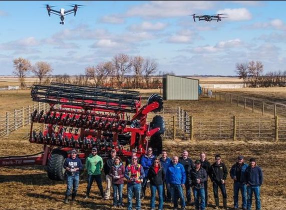
We are back. After Covid-19 shut down most of our springtime schools, we are now ready to start teaching everyone about effective drone use on the farm again.
We will be coming back to all of the locations we had scheduled in the fall and next spring. But with some restrictions being eased, we've added two quick impromptu summertime Alberta locations:
Bezanson on August 10-11
If you've been thinking of using a drone on your farm, register now to join us in this time just before swathing starts.
Transport Canada released very clear new rules that "crack down" on recreational use, but the rules are great news for farm use. You now just need to pass Transport Canada's online test to get a Basic Pilot's Certificate and register the drone. You'll get the knowledge to pass that test on day two of our school.
But we go much further than just certification -- we are passionate about practical uses for drones for agriculture. We do NOT see drones as fun toys - we'll show you 101 ways drones have been used as valuable farm tools.
Even if you've never flown a drone before, you will be comfortable with basic maneouvers after the first day. And you'll be ready to start autonomous mapping missions after the second day - with lots of hands-on practice along the way.
Register at landview.com or call (780) 448-7445 for more info.
We will take extra precautions to prevent spread of Covid-19:
self-exclusion requirements, 2 metre separation, required hand-washing before any hands-on instruction, sanitizing of equipment, and limited class size.
No picture like the one above this time around, sorry. But you will get to fly!Your $590 registration fee includes:16 hours of instructionTraining materialsPractice before & after the course with a Tello drone
(yours to keep, a $139 value)Lunches both daysAlready own a drone?
We will happily discount the course $100 if you decline the DJI Tello.Already have a drone?
Perfect, bring it along.
But most importantly, by attending an RPAS Ground School you will be on your way to flying legally. We will even have laptops at the school, if you want to take the test right then.
Perfect, your chance to understand the options.
Not sure about multispectral vs near-infrared conversion vs thermal infrared imaging?
You will have the opportunity to see these systems in action, before you buy. We will go through the different types of sensors and software -- and how you get value out of them for agronomy.
Armasuisse contracted Lockheed Martin (LMT) for a fleet of Indago 3 small unmanned aircraft systems (UAS), with options for spares, training and tech support and additional systems for the Swiss Army.
Indago provides aerial reconnaissance in environments unreachable by normal fixed-wing, unmanned aircraft systems.
The first phase comprises manufacturing development to optimize the Indago 3’s configuration to meet Swiss Army requirements. These include:
- Integration of a transponder for sense and avoid;
- Installation of the Silvus Technologies’ radio; and
- Implementation of Lockheed Martin CDL Systems’ VCSi Touch SUAS Ground Control System software that includes access to Swiss maps, including digital terrain elevation data (DTED), and Geofencing.
The first set of optimized systems will be delivered later this year with the remaining systems to be delivered several months following the first delivery. These Indago 3s will support tactical level reconnaissance and surveillance to support information collection, search and rescue, disaster relief and battle damage assessment.
“Indago 3 is uniquely qualified to support the Swiss Army’s mission needs,” said Steve Fortson, UAS Portfolio manager at Lockheed Martin. “Indagos operate very quietly from relatively low altitude and provide high fidelity sensor imagery. They are simple to use and require minimal training so soldiers can quickly execute their mission. The Silvus Technologies radios also deliver best-in-class performance and efficiency in a miniature package. They’re ideal for use in portable and embedded applications where size, weight, power and cost are key.”
Depending on payloads and operating environment, Indago 3 has a flight time of up to 50 minutes, a range of 10 kilometers, a cruise speed of 25 knots and dash at up to 40 knots. It can also operate at temperatures as low as 30-degrees below zero and as high as 120 degrees Fahrenheit. It’s cyber-secure with high fidelity color and infrared 3-axis stabilized sensors – and at approximately 5 lbs., Indago can be easily transported by a single backpack and deployed in less than three minutes.
To learn more about Indago 3, visit www.lockheedmartin.com/indago
To learn more about Silvus Technologies, visit https://silvustechnologies.com/
About Silvus Technologies
Headquartered in Los Angeles, Silvus Technologies develops world-class advanced communications technologies that are reshaping the tactical wireless communications landscape. Silvus’ revolutionary Mobile Networked MIMO technology utilizes a proprietary blend of MIMO antenna techniques, COFDM modulation, and Mobile Ad Hoc Networking to provide unmatched range, throughput, and mobility, even in the most challenging environments. From pure line-of-sight to extreme non-line-of-sight, Silvus’ radios facilitate reliable duplex connectivity between 2 or more radios, forming a self-healing, self-forming mesh network that continually optimizes itself in response to changing channel conditions.
About Lockheed Martin
Headquartered in Bethesda, Maryland, Lockheed Martin is a global security and aerospace company that employs approximately 110,000 people worldwide and is principally engaged in the research, design, development, manufacture, integration and sustainment of advanced technology systems, products and services
By PRESS
DroneShield Ltd (ASX:DRO) (“DroneShield” or the “Company”) is pleased to announce an order for the Company’s RadarZeroTM portable counterdrone system, powered by the DroneShieldCompleteTM Command-and-Control (“C2”) system, from a significant European military.
At $100,000 in sales proceeds, this is an order for an evaluation, expected to lead to additional deployments with this Ministry of Defence customer.
RadarZeroTM is a revolutionary ruggedised (IP68, -40C to +75C) metamaterials based radar, weighting only 1.25kg, enabling effective detection and tracking of nefarious drones. DroneShieldCompleteTM C2 enables an intuitive user interface and a rich reporting functionality of drone threats.
Oleg Vornik, DroneShield’s CEO, has commented, “The importance of this sale is several-fold. First, this is our first order from this European military. Secondly, this is the first sale of a radar-only fixed site system powered by DroneShieldCompleteTM, demonstrating the modularity of our offering. DroneShield is both a sensor manufacturer and an integrator, with the customer having ability to add further sensor loads to the acquired system, which DroneShieldCompleteTM supports.”
The sale is subject to pending relevant export approvals.
By PRESS
TEKEVER UAS perform regular Beyond Line of Sight operations in close cooperation with manned assets
. TEKEVER systems have been used in the heart of the Mediterranean Sea to monitor illegal migration
“COVID-19 highlights the importance of unmanned technology”, said Ricardo Mendes TEKEVER CEO
Lisbon, July, 2020 – TEKEVER announces that its unmanned systems have surpassed 2,000 flight hours in support of maritime surveillance missions in Europe. The company has been carrying out operations using its AR3 and AR5 systems, which offer more than 16 hours of endurance, for maritime surveillance, pollution monitoring and supporting the fight against trafficking, illegal migration and illegal, unreported and unregulated fishing.
The surveillance missions, in partnership with local authorities, have mostly carried out within European airspace with an emphasis on Italy, Spain and Portugal, among others.
However, the company is also extending its services in other parts of the world, operating in more than twenty countries. In African and Southeast Asian countries, where the TEKEVER’s products and services are gaining very notable interest, the company also offers support to multiple types of land-based missions, including detection and monitoring services for rural and forest fires.
“In addition to developing cutting edge technology, we’ve had the opportunity to be deeply involved in hundreds of maritime surveillance missions, operating our systems to provide our customers with actionable, real-time intelligence”, states Ricardo Mendes, TEKEVER’s CEO.
“Our operational teams have now thousands of hours of experience across our platforms, make our products simpler and safer to use, more mission effective and operationally more efficient. We’re working everyday with security forces and aviation authorities in Europe and abroad, bringing them this accumulated experience to help make unmanned systems a wide-spread reality in support of non-military operations throughout the world”, added the Ricardo.
“Part of our mission is to help detect situations where lives can be saved and provide the
authorities with intelligence that can prevent further illegal activities. During the
pandemic, we’ve witnessed a meaningfully increase in demand for our products and
services. COVID-19 highlights the importance of unmanned technology, as it provides the
authorities with tools that can be effective even while operated from a distance in safe
environment”, said Mendes.
It is important to remember that in 2017 TEKEVER was awarded contracts by the European Maritime Safety Agency (EMSA) that could be worth up to EUR 77 million, to set up the first commercial European maritime surveillance and environmental monitoring service based on unmanned technology. Operations have been ongoing for over two years, and TEKEVER systems are being used in the heart of the Mediterranean Sea to monitor trafficking, illegal migration and IUU (illegal, unreported and unregulated) fishing, in operations that are closely coordinated with other airborne, maritime and land-based assets from each countries’ security forces.
TEKEVER’s unmanned systems are developed and produced in Europe, in development centers and manufacturing facilities in the United Kingdom and Portugal.
By PRESS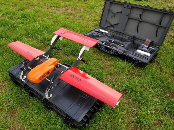
Transport Canada has approved FIXAR’s revolutionary drone design for flights in Canada, meaning the FIXAR can start flying missions in controlled airspace and near people – opening the skies to commercial and industrial clients.
This breakthrough occurs as the company officially launches its product in the North American market.
The approval means that Transport Canada is satisfied the FIXAR drone meets federal requirements in accordance with Part IX of the Canadian Aviation Regulations (CARs) and that this Remotely Piloted Aircraft System (RPAS) is suitable for Advanced Operations in both controlled and uncontrolled airspace in Canada.
“We are thrilled with this approval – and to bring the unique FIXAR VTOL solution to North America,” says Vasily Lukashov, FIXAR CEO and inventor. “ This design has all of the benefits of both quadcopter and fixed-wing drones, with none of their downsides.”
The FIXAR takes off like a helicopter and flies like an airplane. Technically, this is referred to as a Fixed-Wing Vertical Take-off and Landing device, or VTOL. It’s a design that offers the convenience of a quadcopter but has the range and efficiency associated with a traditional winged design. It can take off and land anywhere, and no cumbersome launchers or capture devices are required.
Most VTOL drones with wings require that the angle of the motors change when transitioning from vertical to horizontal flight. FIXAR uses a patented Fixed Angle Rotor system, meaning fewer moving parts or potential points of failure. Transitions are seamless, and all motors are in use throughout missions. Unlike designs that shut down motors during forward flight, the FIXAR carries no “dead weight” during missions.
This configuration, in conjunction with its two-kilogram payload capacity, makes the FIXAR ideal for a multitude of applications. These tasks include: Aerial photography and mapping/
photogrammetry, laser scanning (LiDAR), last-mile delivery, precision agriculture, critical
infrastructure monitoring and more.
“These drones have a simple but superb design, something I appreciate as a professional commercial pilot,” says Philippe Saint-Martin, who is the FIXAR distributor for Canada. “The moment I saw one of these fly, I knew they would fill an obvious void in the RPAS world.”
The FIXAR drones, designed by Vasily Lukashov and manufactured in Latvia, also utilize Closed-Source software and proprietary hardware for additional safety and security, including data integrity. The product offers a stable and reliable platform that’s already gaining interest from service providers globally.
FIXAR products are now available in Canada through a partnership with Videodrone,
videodrone.ca.
Inquiries to Philippe Saint-Martin can be made by email: info@videodrone.ca.
FIXAR (fixar.pro) is a developer and manufacturer of integrated unmanned aerial solutions for industrial uses. Founded in 2017 by aerospace developer
Vasily Lukashov, the company holds a unique patented design that is simpler and more reliable than other configurations. The company began selling its products in Eastern Europe and Central Asia at the close of 2019. It entered the Canadian and US markets in July, 2020
———
By PRESS
Minneapolis-area police controversially used drones to spot people illegally taking their clothes off at an unofficial nude beach, according to a report from local CBS affiliate WCCO.
Numerous online sources say the Twin Lake beach has a long history of nudity, but legally anyone nude and any women exposing their breasts are violating the law. A group of officers from the Golden Valley Police Department and Minneapolis Parks Police sent in the drones after receiving “a dozen complaints this spring and summer regarding people being nude, drinking alcohol or doing drugs at the beach,” according to the report.
The devices caught images of people exposing parts of their bodies they later covered up when officers arrived on the beach. The police say the drone surveillance is legal, since the beach is a public place, but it understandably made some beachgoers uncomfortable. Some also consider the current law discriminatory—it allows men to be topless but not women—and the Minneapolis Park and Recreation Board is considering changing it, according to the report.
People at the beach also accused police of singling out Black beachgoers, approaching them first, and pushback from the crowd ultimately made the officers leave, according to the report.
“We made the choice that things were only escalating, and we chose to leave,” Golden Valley Police Department Sergeant Randy Mahlen told WCCO.