User blog: Bruce McPherson
The Thornton Law Firm alerts investors that a class action lawsuit has been filed on behalf of investors of EHang Holdings Limited (NASDAQ:EH).
The case is currently in the lead plaintiff stage. Investors who purchased EH stock or other securities between December 12, 2019, and February 16, 2021, may contact the Thornton Law Firm’s investor protection team by visiting www.tenlaw.com/cases/EHang to submit their information. Investors may also email investors@tenlaw.com or call 617-531-3917.
The complaint alleges that EHang and its senior executives made misleading statements to investors and failed to disclose that: (i) EHang’s purported regulatory approvals in Europe and North America for its EH216 were for use as a drone, and not for carrying passengers; (ii) its relationship with its purported primary customer is a sham; (iii) EHang has only collected on a fraction of its reported sales since its ADS began trading on NASDAQ in December 2019; and (iv) EHang’s manufacturing facilities were practically empty and lacked evidence of advanced manufacturing equipment or employees.
Interested EHang investors have until April 19, 2021, to retain counsel and apply to be a lead plaintiff if they are interested to do so. Investors do not need to be a lead plaintiff in order to be a class member. A lead plaintiff acts on behalf of all other investor class members in managing the class action. If investors choose to take no action, they can remain an absent class member. The class has not yet been certified. Until certification occurs, investors are not represented by an attorney.
Thornton Law Firm’s securities attorneys are highly experienced in representing investors in recovering damages caused by violations of the securities laws. Its attorneys have established track records litigating securities cases in courts throughout the country and recovering losses on behalf of investors. This may be considered Attorney Advertising in some jurisdictions. Prior results do not guarantee or predict a similar outcome with respect to any future matter.
By PRESS
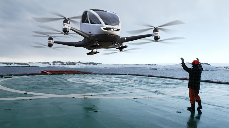
Oh dear, Wolfpack has looked properly at EHang.
In their own words, Wolfpack is a global financial research & due diligence firm dedicated to protecting investors by ensuring the natural balance of the financial ecosystem.
Pretty meaningless to me! But the fact that people that understand investing and stuff are looking properly at AAM/UAM companies is important.
It might start to lift the curtain on VC backed BS that makes up 90% of the current market.
EHang has a great smaller delivery platform that they should be pushing but its the manned flying car that has lifted them above the crowd.

This is what Wolfpack said about EHang and below that, the response from EHang. As I type the AAM darling is 60% down in trading.
We are short Ehang.
Today, we reveal why we believe EHang NASDAQ: EH is an elaborate stock promotion, built on largely fabricated revenues based on sham sales contracts with a customer who appears to us to be more interested in helping inflate the value of its investment in EH i.e., pump EH’s stock price than actually buying its products. EH has perpetuated its story with a collection of lies about its products, manufacturing, revenues, partnerships, and potential regulatory approval of its purported main business, an “autonomous” aerial vehicle “AAV” ridesharing network.
Summary
We conclude that EH’s relationship with its primary purported customer is a sham. Government records and credit reports show that EH’s major customer is Shanghai Kunxiang Intelligent Technology Co., Ltd. hereinafter referred to as “Kunxiang”. We have gathered extensive evidence including behind-the-scenes photographs, recorded phone calls, and videos of on-site visits to EH’s various facilities, as well as Kunxiang’s offices which lead us to believe that Kunxiang signed sham sales contracts to benefit its investment stock price in EH
• Kunxiang has an exaggerated physical presence and its real operations appear to be a fraction of what is claimed. Out of the 3 addresses listed on Kunxiang’s website, one is a hotel with no Kunxiang presence, one is a 13th floor address of an 11-story building, and the last one had only one Kunxiang employee in the office on a weekday afternoon.
• To the extent Kunxiang actually does sell vehicles, it did not want to sell EH’s products to us. When asked, the only employee on-site at Kunxiang, who claimed to be the finance manager, had no hesitation voicing his disapproval of the EH216, and instead offered their own, supposedly much higher quality products for sale.
• Kunxiang appears to be a willing participant in EH’s stock promotion. According to the same finance manager at Kunxiang, Kunxiang made an undisclosed RMB100 million ~$14 million pre-IPO investment in EH, which leads us to believe its true motive for signing these shambolic contracts was to benefit its investment, which is worth ~RMB473 million ~$68 million today.
• As is common with a sham customer, SAIC files and national credit reports show that Kunxiang was established just 9 days before it signed a RMB450 million ~$65 million sales contract with EH. Kunxiang had only RMB10 million ~$1.4 million of registered capital, rendering far too thinly capitalized to actually fulfill this purported sales contract. Nonetheless, Kunxiang signed another RMB30 million ~$4.3 million contract with EH four months later.
• One of the sloppiest details of this “customer/supplier” relationship, the first purported sales agreement between EH and Kunxiang provides that Kunxiang will supposedly pay a per unit “per set” price of RMB150 million ~$21.5 million. We assume that before the second purported agreement was signed four months later, EH realized that the unit price was too high to be believable and cut it to RMB1.5 million ~$215k, 1% of the price in the first contract.
• Between September 10, 2019 and October 31, 2019, EH filed a confidentiality request with the SEC to redact the prices on these contracts, likely because the prices are so absurd that they would ruin EH’s credibility if seen by investors or competitors. We only found the unredacted versions of these contracts within the SEC’s EDGAR archive
Also common with a stock promotion, EH has only collected on a fraction of its reported sales since its mid-December 2019 IPO. We see EH’s collection rate of only 20% and DSOs at nearly 200 days despite its purported credit terms of up to 180 days as a clear indication of fabricated revenues.
• EH has reported RMB125.5 million ~$18 million in total revenues since its December 2019 IPO.
• During the same period, its accounts receivable increased by RMB96.2 million ~$13.8 million.
• This means that EH has only collected RMB25.2million ~$3.6 million in cash since becoming a publicly traded company. Typical of a stock promotion, in just 14 months as a publicly traded company, EH’s PR team has put out 50 press releases, according to Globe Newswire. However, EH’s constant stream of press releases are easily proven untrue. For example:
• EH has announced numerous “flight certifications” and “long-term” approvals for its “passenger-grade” EH216 in the US, Canada and various countries throughout Europe.
• According to aviation regulators or experts in aviation regulation in the US, Canada and Europe, EH has only received permits for recreational test flights of its drones in specified areas, below a specified altitude and at a specified time. In no way are these permits endorsements of EH’s “passenger-grade” claims, nor are they “regulatory breakthroughs” of any kind.
• EH also claims in an English PR to have received the “World’s First Commercial Pilot Operation Approval of Passenger-Grade AAVs for Air Logistics Uses” from China’s CAAC. However, the title of the Chinese version of the same PR says nothing about “commercial” or “passenger-grade” What EH obtained was “特定类无人机试运行批准函” special approval letter for trial runs of drones of a specified class. CAAC had granted the same license to at least one other company in Hangzhou, China one year earlier in 2019.
• EH consistently makes different claims regarding regulatory approvals in the English and Chinese versions of its press releases. In English, EH makes false claims of commercial approval of its vehicles the EH216 by Chinese regulators. In its Chinese press releases, EH makes false claims of commercial approvals by regulators in the US, Canada, and Europe.
EHangs response
EHang Holdings Limited (Nasdaq: EH) (“EHang” or the “Company”), the world’s leading autonomous aerial vehicle (“AAV”) technology platform company, today issued the following response to the allegations raised in a report by Wolfpack Research dated February 16, 2021. The Company strongly believes that the report contains numerous errors, unsubstantiated statements, and misinterpretation of information.
The Company will consider any necessary and appropriate course of action to protect the interest of the Company and all of its shareholders. EHang is committed to maintaining the highest standards of corporate governance, as well as transparent and timely disclosure in compliance with the applicable rules and regulations of the United States Securities and Exchange Commission and the Nasdaq Stock Market.
By Gary Mortimer
The Civil Aviation Authority is welcoming the conviction yesterday of a recreational drone pilot at the Manukau District Court over a “deceptively dangerous” 2018 mid-air collision between his drone and a trainee paraglider at Karioitahi Beach near Waiuku.
The conviction follows Judge Mina Wharepouri finding the man guilty in October 2020 on two charges under the Civil Aviation Act 1990 over his drone being used in a manner causing unnecessary endangerment, and for failing to keep clear of a manned aircraft.
In his judgement, Judge Wharepouri found the drone operator had been overly reliant on the view from his drone’s camera and failed to maintain visual line of sight of the drone when he hit the paraglider about 100 metres above the ground.
The CAA’s Deputy Chief Executive Aviation Safety, Dean Winter, says it’s lucky the paraglider pilot wasn’t killed or seriously injured in the collision, and he hopes this case serves as a wake-up call to other drone users.
“This conviction shows there can be real consequences when drone users fail to follow the rules and put the lives of others at risk through their lack of understanding or carelessness,” Mr Winter said.
“Although the pilot of the paraglider pilot was able to safely walk away after the collision, the accident was deceptively dangerous and it was only down to sheer luck and the skill of the paraglider that there wasn’t a death that day.”
This prosecution was the first in New Zealand over a collision between a drone and manned aircraft. It demonstrates the CAA’s commitment to take occurrences involving the dangerous use of drones seriously, particularly when there’s a threat to other aircraft or people on the ground below.
Drone users can learn more about the Civil Aviation Rules at www.aviation.govt.nz/drones.
Six key rules all drone users should know
- Always fly below 120 metres.
- Don’t fly over people without permission.
- Keep your drone in sight at all times.
- Stay 4 km away from aerodromes and helipads.
- Give way to all manned aircraft. Land immediately.
- Don’t fly over property without permission.
Notes to the editor
- The drone pilot was convicted and fined $1000 on two charges:
- Operating a drone in a manner that caused unnecessary endangerment pursuant to s44 of the Civil Aviation Act 1990;
- While operating the drone, failed to give way and keep clear of a manned aircraft as required by Civil Aviation Rule 101.213(a).
senseFly, the global leader in fixed-wing mapping drones, today announces the launch of eBee Ag, the latest addition to the eBee X series of drone solutions. User-friendly and affordable, eBee Ag helps farmers, agronomists and service providers efficiently capture aerial data and plant health insights for faster agronomic decision-making that can improve crop yields and profit potential.
“The agriculture industry has been lacking a viable mapping solution that offers professional results at a more accessible price,” explains Michael O’Sullivan, senseFly Head of Marketing. “The launch of the eBee Ag introduces an affordable fixed-wing solution that delivers the long flight times, range and efficiency—as well as the data quality, accuracy and resolution—that agriculture mapping projects require.”
Based on senseFly’s flagship eBee X fixed-wing drone, eBee Ag helps agriculture professionals overcome the many challenges they face in the field related to planning, plant health and crop monitoring. eBee Ag makes it easier than ever to field scout, ground-truth potential problem areas and gain critical crop health and field information.
eBee Ag is suited for intensive and repeated crop mapping missions. Equipped with its standard battery, it is capable of up to 45-minutes of flight. An endurance battery increases flight times to up to 55 minutes—allowing eBee Ag to cover more than 160 hectares (395 acres) in a single flight and saving precious time and money when compared with conventional scouting.
eBee Ag features senseFly’s new, lightweight Duet M dual-sensor fixed payload, which comprises the senseFly S.O.D.A. RGB and Parrot Sequoia+ multispectral cameras. With its dual-purpose camera, eBee Ag captures accurate RGB and multispectral data from the sky to help make better decisions on the ground. Regularly collecting multispectral data is critical to effectively assess crop health, optimize inputs and catch early indicators of pests, diseases and weed infestations that threaten crop yields. Highly-accurate index maps allow agriculture professionals to understand each acre while managing problematic areas field-wide – before they impact profits.
eBee Ag also features available Real-Time Kinematic (RTK) functionality for greater mapping precision. With its available RTK, eBee Ag can achieve absolute accuracy down to 2.5 cm (1 in) with RGB. This position data can then integrate seamlessly into existing GPS-enabled machinery and/or Farm Management Systems.
eBee Ag also comes with senseFly’s new eBee X series backpack, which is a smart and durable way to carry everything needed to transport the drone into and out of the field.
The eBee Ag shares its DNA with senseFly’s flagship eBee X fixed-wing mapping drone, which revolutionized the unmanned aerial vehicle sector with its ease-of-use and multiple, state-of-the-art sensors. With a unique Endurance Extension option enabling a flight time of up to 90 minutes and single-flight coverage of up to 500 ha at 122m (1,236 ac at 400 ft.), the eBee X is a premium solution that offers users the high-precision of on-demand RTK/PPK for achieving absolute accuracy of down to 1.5 cm (0.6 in)—without ground control points.
Farmers, agronomists and other agriculture professionals—including enterprise organizations, who purchase eBee Ag or any drone from the eBee X line—get access to senseFly’s intuitive eMotion flight planning software, technical support and resource offerings, including its in-house team of experts, global distribution network and the newly launched senseFly Academy e-Learning Training Platform and Certified Operator Program.
For more information on the new eBee Ag fixed-wing solution and the rest of the eBee X series, please visit senseFly.com or contact your local authorized senseFly distributor.
Autonomous trucks need to warn e-bikes of their presence to avoid accidents, first responders need to know the position of critical medical drones with pinpoint accuracy, and operators need to precisely locate precious cargo. Vodafone customers will have applications that do all that and more thanks to a new technology it is testing.
Vodafone has successfully used new precision positioning technology to remotely track a vehicle to within just 10 centimetres of its location, an improvement of more than three metres compared with current standard satellite based systems. It did this in partnership with leading global positioning provider Sapcorda, using Vodafone’s global Internet of Things (IoT) platform – the largest in the world with 118 million connections.
Pinpoint accuracy is critical to the acceptance and mass adoption of autonomous vehicles not just on the road but in factories, airports, dockyards and any site where machines are in motion. A matter of centimetres could be crucial to ensuring the safety of passengers on a driverless bus, or knowing the precise location of a medical drone. It will also allow an autonomous truck to mind other road users, including cyclists, whose e-bikes can automatically transmit their position and intended direction of travel.
Vodafone Business Platforms and Solutions Director Justin Shields said: “We might not be able to locate a needle in a haystack yet, but we are getting close. What we can do now is take new digital services like this one, integrate it with our global IoT platform and fast networks, and offer it securely at scale to many millions of customers.
“Our in-building 5G and IoT services already allow manufacturing plants, research laboratories and factories to carry out critical, and often hazardous, precision work with robots. Now we are applying the same levels of accuracy to the outdoor world.”
The new precise positioning service is another example of how Vodafone is redefining its network and technology on a ‘Telco as a Service’ (TaaS) model. By identifying key network capabilities, and making them available through common APIs in a cloud platform, Vodafone is delivering new software, video and data applications at scale, in addition to gigabit-capable connectivity.
Vodafone believes that large enterprises will benefit hugely from these new technologies. For example, they will be better able to locate critical assets, precisely align machines such as driverless trains at platforms and let farmers, airports, and fleet operators know the exact whereabouts of their autonomous vehicles, buggies and cars at any given time.
Vodafone IoT-enabled vehicles, machinery and devices, when linked with Sapcorda’s comprehensive network of Global Navigation System Service (GNSS) receivers and augmentation technology, improves location accuracy by correcting for things like the curvature of the earth, atmospheric delays and clock differences of global positioning satellites. This offers corporations hyper-precise positioning which they can utilise to ensure a safe environment for their employees, their customers, the public and their machines.
Combined with video and on-board diagnostics, the technology will also allow vehicle operators to carry out accurate location sensitive remote inspections and even pause machines such as grass cutters on public footpaths when they encounter people.
Note to Editors
Vodafone is adopting the Precise Point Positioning – Real Time Kinematics (PPP-RTK) method with ground level GNSS stations to achieve the best error correction. Signals from global positioning satellites are processed and GNSS corrections are sent out to enhance the position accuracy of the vehicles receiving them. Vodafone is able to equip any number of vehicles with an in-built IoT SIM, and deliver the positioning data at speed using its gigabit-capable networks.
Vodafone recently put this to the test by tracking in real-time the exact lane that vehicles were travelling in during a combined journey of over 100 kilometres in varying weather conditions. Sapcorda provided the data feed, which enabled the GNSS signal to be corrected, to deliver the critical level of positional accuracy. A Precise Positioning Service complements the existing asset tracking and fleet telematics solutions already provided by Vodafone Business for enterprise customers across 54 countries.
By PRESS
United Airlines believes that soon we’ll all be taking air taxis to the airport—and it just ponied up big bucks to get in on the action. The airline has just announced that it will invest more than $1 billion in Archer Aviation, a start-up developing electric vertical takeoff and landing aircraft.
The startup says its eVTOLs, which are being positioned as commuter air taxis, will be able to shuttle passengers some 60 miles on a single charge and hit speeds of up to 150 mph. While still in the prototype stage, the full-scale aircraft is scheduled to be unveiled later this year, with mass production slated for 2023. According to Archer, jet setters can expect to see this zero-emissions aircraft servicing airports in United’s major hubs by 2024.

The electric aircraft will shuttle passengers up to 60 miles at speeds near 150mph. Jeff Ludes/Archer Aviation
“Archer’s eVTOL design, manufacturing model and engineering expertise has the clear potential to change how people commute within major metropolitan cities all over the world,” United CEO Scott Kirby said in a statement.
Indeed, the airline estimates that flying one of Archer’s eVTOLs between Hollywood and Los Angeles International Airport (LAX) could reduce CO2 emissions by up to 50 percent per passenger. Coincidentally, Los Angeles is one of the first cities Archer plans to launch its fleet and one of United’s largest hubs.

The aircraft could start servicing airports in United’s major hubs by 2024. Jeff Ludes/Archer Aviation
United isn’t the only party getting in on the Archer action, either. Separately, the startup announced that it reached an agreement to merge with special purpose acquisition company Atlas Crest Investment Corp. to become a publicly listed company. The combined company, soon to be listed on the New York Stock Exchange under “ACHR,” will have an equity valuation of $3.8 billion. Archer also said it expected to receive $1.1 billion of gross proceeds to fund future growth, including $600 million in private investment in public equity (PIPE) from investors such as Stellantis and United. Fiat Chrysler also recently announced a partnership with Archer to develop flying cars.
It could be a prescient move. Morgan Stanley predicts that the market for eVTOLs could reach $1.5 trillion in the next 20 years. If that prognostication bears out, early investors stand to be rewarded handsomely.
By RACHEL CORMACK
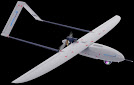
Ottawa, CA: Kongsberg Geospatial announced today that it has been selected by Defence Research and Development Canada (DRDC) to conduct trials of a new long-endurance UAV surveillance system for the Canadian Coast Guard. The MartinUAV V-BAT aircraft was selected to provide the unique ability to combine take off and landing from the small confines aboard ship with the long endurance of a fixed-wing aircraft while carrying multiple sensors.
Combining a unique Vertical Take-off aircraft and new sensor data PED solution allows for rapid collection and analysis of sensor data
The aircraft will communicate with the Kongsberg Geospatial sensor data management system, called MIDAS, which allows a range of sensor data, including full-motion video from unmanned systems to be processed and exploited in near real-time by analysts on board Canadian Coast Guard ships. MIDAS provides the capability to compare historical and live data from the mission area, and to examine sensor data with a variety of tools, including motion and object detection, in near-real time. This near real-time analytical capability can greatly enhance the effectiveness of UAVs for a variety of mission types.
The V-BAT Unmanned Aerial System (UAS) provided by Martin UAV is a fixed-wing vertical take-off and landing (VTOL) aircraft specifically designed to operate from very small spaces on ships, land, and nearly any environment. The V-BAT is a long-endurance aircraft capable of carrying multiple sensors, including land and maritime wide area surveillance.
Kongsberg Geospatial’s MIDAS is derived from technologies created for the NATO Alliance Ground Surveillance project which required the storage and retrieval of vast amounts of intelligence data for Intelligence Analysts. The system directly addresses the problem that the vast majority of UAVs have no standards-compliant capability to process, exploit, and distribute (PED) their sensor data where it is being used. MIDAS provides a fully standards-compliant system that allows intelligence analysts to view, process, and analyze sensor data in near real-time, from where the drone is being operated. MIDAS has packaged these capabilities into a tactical and portable form factor to enables those surveillance capabilities to be deployed as a portable system on board a ship, or in a temporary command post.
CINTIQS Military Technology Consulting will be providing consulting services for the planning and conduct of the flight trials and sensor employment to validate systems performance.
The combination of the Martin UAV V-BAT and the Kongsberg MIDAS sensor data management system will allow Coast Guard vessels to significantly expand their surveillance range for search and rescue missions, and for the surveillance of the movement of icebergs, without requiring the use of manned aircraft.
“UAVs are a useful tool, but they only truly effective if they can collect sensor data that results in actionable intelligence”, said Ranald McGillis, President of Kongsberg Geospatial. “Our MIDAS system allows users to fully exploit raw sensor data, and derive useful intelligence at the tactical edge where the UAV is being used. In a search and rescue context, that could mean using infrared sensors, or near real-time motion detection to locate a subject when visibility or weather conditions are poor.”
About Kongsberg Geospatial: Based in Ottawa, Canada, Kongsberg Geospatial creates precision real-time software for mapping, geospatial visualization, and situational awareness. The Company’s products are primarily deployed in solutions for air-traffic control, Command and Control, and air defense. Over nearly three decades of providing dependable performance under extreme conditions, Kongsberg Geospatial has become the leading geospatial technology provider for mission-critical applications where lives are on the line. Kongsberg Geospatial is a subsidiary of Kongsberg Defence & Aerospace.Media contact:1-800-267-2626 or reach us by email at info@kongsberggeospatial.com
About Martin UAV: Based in Plano, TX, the mission of Martin UAV is to build the world’s most advanced unmanned systems. Our technology team specializes in building tactical systems from the ground up, addressing the vast capability gaps left by legacy technologies and current government programs of record around the world. With decades of research and development, our platforms offer cutting edge applications and engineering feats unmatched in the government or commercial sectors of today.
About CINTIQS: Based in Ottawa, Canada, CINTIQS is a veteran-owned and operated MilTech (Military Technology) business focused on helping Canadian technology companies solve the problems that matter most to those in uniform. CINTIQS represents the highest concentration of tactical, operational, and strategic-level military intelligence expertise in Canada. In combination with their technical and industry/business depth, the company provides the expertise you need to succeed in the ultra-competitive global defence market.
About the Canadian Coast Guard: Headquartered in Ottawa, the Canadian Coast Guard is the coast guard of Canada. Founded in 1962, the coast guard is tasked with marine search and rescue, communication, navigation and transportation issues in Canadian waters, such as navigation aids and icebreaking, marine pollution response and providing support for other Canadian government initiatives. The coast guard operates 119 vessels of varying sizes and 22 helicopters, along with a variety of smaller craft.
About DRDC: Based in Ottawa, Canada, Defence Research and Development Canada is the Department of National Defence’s and Canadian Armed Forces’ science and technology organization. DRDC develops and delivers new technical solutions and advice for not only DND/CAF, but also other federal departments, and the safety and security communities.
By PRESS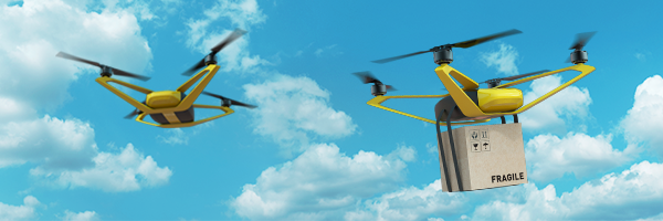
ABOUT THE ICAO DRONE ENABLE WEBINAR SERIES:
This site provides the details and registration information for the ICAO DRONE ENABLE Webinar Series. The intent of this series of webinars is to foster the conversations around several key issues relating to unmanned aircraft system (UAS) and UAS traffic management (UTM). Additional topics applicable to the continued advancement of UAS, UTM systems, and urban/advanced air mobility (UAM/AAM), as well as the presentations selected from this year's request for information (RFI) submissions will be discussed during DRONE ENABLE 2021 being held 13-15 April and 20-21 April 2021.
WEBINAR SERIES TOPICS:
Session 1
New Operating Environment and Flight Rules
25 February 2021, 0900 Montreal (90 minute webinar)
For more information and registration, click here.
Session 2
Road to Higher Autonomy
4 March 2021, 0900 (90 minute webinar)
Information to be posted soon.
Session 3
Aeronautical Information Management for Unmanned Traffic Management (AIM for UTM)
11 March 2021, 0900 Montreal (90 minute webinar)
For more information and registration, click here.
Session 4
Human Dimension in Unmanned Traffic Management
24 March 2021, 0900 (90 minute webinar)
Information to be posted soon.
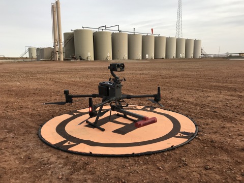
A drone fitted with the SeekOps SeekIR® sensor ready to deliver a fugitive emissions detection service. (Photo: Business Wire)

AUSTIN, Texas--(BUSINESS WIRE)--Sky-Futures, an ICR company, one of the world’s leading drone inspection and survey providers, has signed a global service delivery partnership with SeekOps Inc to provide methane detection, localisation, and quantification services to customers around the world.
“The world is changing fast and there is an increasing market demand for dependable leak detection technologies. SeekOps provides technologies that can be used to detect, locate, and quantify leaks, and the technology is highly accurate, lightweight, and field-proven. ”
With a global footprint in 9 countries and operations in over 33 countries to date, Sky-Futures will deliver a SeekOps-certified service to customers both onshore and offshore. The partnership will enable SeekOps to rapidly scale the delivery of its methane emissions detection services globally to customers across multiple sectors, including the oil and gas and biogas industries.
Established as best-in-class for methane detection and quantification, the drone-mounted SeekIR® sensor enables cost-effective comprehensive emissions inspection in a fraction of the time required by traditional ground surveys, resulting in significant cost savings for operators.
Working together, Sky-Futures and SeekOps will provide customers with an end-to-end service including data capture, data analysis and reporting. The SeekOps drone-based sensors operate in concert with their custom data analytics software, to rapidly localise point source emissions and quantify emissions rates.
Iain Cooper, CEO of SeekOps said, “The world is changing fast and there is an increasing market demand for dependable leak detection technologies. SeekOps provides technologies that can be used to detect, locate, and quantify leaks, and the technology is highly accurate, lightweight, and field-proven.
“We are delighted to be partnering with Sky-Futures, to bring our highly-effective leak detection and quantification abilities into the global marketplace. This partnership enables us to provide rapid, robust, reliable and repeatable quality solutions to our customers’ emissions needs anywhere in the world and in all aspects of oil and gas - upstream, midstream and downstream, as well as to the nascent but rapidly expanding biogas and landfill monitoring markets”.
Sky-Futures delivers a range of services across multiple sectors with significant experience in the onshore and offshore oil and gas market. This experience is a fundamental piece of the partnership between the Sky-Futures and SeekOps and will support the rapid roll out of the technology and service to customers around the world.
Chris Blackford, CEO of Sky-Futures said: “As a company with significant experience using drone technology to provide survey and inspection services to the oil and gas industry, we are always looking to partner with companies providing new, innovative and value adding technology. SeekOps tick all these boxes and more. Their drone-based fugitive emission detection technology is class-leading and meets a need that is ever more important in a world where emission monitoring is becoming more regulated.”
About Sky-Futures
Sky-Futures (an ICR Integrity company) provides drone-based inspection and survey services to the industrial markets. With 10 years of experience in over 33 countries, we are one of the leading drone-based inspection and survey service providers globally.
We support a range of industrial markets including: oil and gas; engineering; bridges; renewables; solar; utilities; telecoms and more. Our solution is powering drone-based inspections globally and changing the way data is collected, analysed and used to make better inspection and maintenance decisions.
About SeekOps Inc.
SeekOps Inc. provides advanced methane emissions solutions for the energy sector to detect, localize, and quantify methane emissions through integrated drone-based systems. SeekOps’ unique SeekIR® sensor design and proprietary algorithms eliminates false positive readings and quantifies emissions sources to provide actionable data to oil and gas and biogas operators globally. SeekOps provides best-in-class technology to meet increasingly stringent environmental, sustainability and governance (ESG) reporting requirements, and enables producers worldwide realize their goal to reduce methane intensity from operations.
BOCA RATON, Fla., Jan. 28, 2021 /PRNewswire/ -- AE Industrial Partners, LP ("AEI"), a private equity firm specializing in Aerospace, Defense & Government Services, Power Generation, and Specialty Industrial markets, announced today that it has acquired UAV Factory, a global leader in the tactical Unmanned Aerial Vehicle (UAV) and Intelligence, Surveillance, Reconnaissance (ISR) technology markets. UAV Factory will be a new standalone unmanned technology platform for AEI, as the firm looks to further invest in this fast growing market. Terms of the transaction were not disclosed.
Founded in 2009, UAV Factory is a global leader in tactical UAV design and manufacturing, having delivered more than 300 aircraft to defense, intelligence, and commercial customers in more than 55 countries. The Company has a unique vertical integration strategy, whereby it designs and produces airframes, engines, stabilized EO/IR ISR payloads and related components in-house for the unmanned and manned aircraft industry. UAV Factory's Penguin C series UAV, which reliably delivers an industry-leading 20 hours of flight time, as well as its proprietary Octopus ISR gyro-stabilized sensors, are widely used by customers globally for a variety of critical ISR missions. UAV Factory is based in Riga, Latvia, with a second location in Bend, Oregon.
"UAV Factory's engineering and technical capabilities, combined with its proven and growing set of technology solutions, are truly differentiated in the market," said Jeffrey Hart, Principal at AEI. "We are excited to partner with the talented UAV Factory team and are confident that our collective strategic vision for an unmanned technology platform will yield powerful results in this fast-growing market."
"The UAV market is growing exponentially, and with the financial and operational support of AEI, UAV Factory is poised for increased growth and market share," said Konstantin Popiks, Co-Founder of UAV Factory, who will remain with the Company in a senior leadership role. "By working closely with the AEI team, we plan to expand our technologies to provide our customers with the best-in-class, end-to-end solutions they need to make critical decisions."
"UAV Factory is at the forefront of the burgeoning global UAV market," said Kirk Konert, Partner at AEI. "Its first mover advantage and unique vertical integration of its proprietary technology solutions well-positions the Company to expand its share of this high growth market."
Kirkland & Ellis served as legal advisor and PricewaterhouseCoopers served as financial advisor to AEI. Blank Rome and Walless served as the legal advisor and Houlihan Lokey was the financial advisor to UAV Factory.
About UAV Factory
UAV Factory, the leader in the small fixed-wing UAV segment, was established in 2009 with the goal of developing the most advanced technology in the small, long-endurance unmanned aircraft market.
The Company develops and produces fixed-wing UAV, UAV subsystems, stabilized EO/IR camera payloads and accessories for the unmanned and manned aircraft industry. UAV Factory heavily invests in research and development and manufactures most of its UAV subsystems in-house. For more information please visit www.uavfactory.com.
About AE Industrial Partners
AE Industrial Partners is a private equity firm specializing in Aerospace, Defense & Government Services, Power Generation, and Specialty Industrial markets. AE Industrial Partners invests in market-leading companies that can benefit from our deep industry knowledge, operating experience, and relationships throughout our target markets. AE Industrial Partners is a signatory to the United Nations Principles for Responsible Investment. Learn more at www.aeroequity.com.
NEWS PROVIDED BY
AE Industrial Partners