User blog: Bruce McPherson
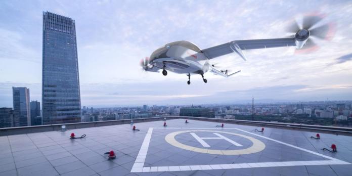
Honeywell (NYSE: HON) has formed a new business unit dedicated to the growing Unmanned Aerial Systems and Urban Air Mobility (UAM) industries. The Unmanned Aerial Systems (UAS) business unit will continue Honeywell’s momentum and leadership in these emerging markets, utilizing Honeywell’s technology, software, services and certification expertise to meet customers’ needs in these markets.
“Urban Air Mobility and Unmanned Aerial Systems will play an increasing role in the future of aerospace, with potential applications in all-electric urban air taxi vehicles, hybrid-electric unmanned cargo drones, optionally piloted airplanes, delivery drones and everything in between,” said Mike Madsen, president and CEO, Honeywell Aerospace. “Honeywell has already contributed many technological advancements to these markets, and is well positioned to continue growing our portfolio to meet customer needs and help shape the future of autonomous aviation and urban transport.”
Equipped with its own engineering and sales resources, the UAS business unit will develop new products and services uniquely required for these markets. It will also act as a systems integrator for all Honeywell products and services that could be used in this industry. These offerings include aircraft systems such as avionics, electric and hybrid-electric propulsion and thermal management, flight services such as unmanned air traffic management, and ground operations services such as predictive aircraft maintenance analytics. Beyond technology development, this business will be a single point of contact for innovative aircraft designers or operators to easily do business with Honeywell.
“We’re seeing the dawn of a new era in aviation, and Honeywell is at the forefront,” said Stéphane Fymat, vice president and general manager of the newly formed business. “By forming this new organization, we will be able to harness the power of our engineering resources and know-how to transform urban air taxis, drone delivery of parcels and all forms of autonomous flight from a future vision into an everyday reality.”
The new organization will further expand Honeywell’s growing portfolio of UAM solutions, and is heavily focused on software development, driving rapid development and testing of new products like:
- A “fly-by-wire” autopilot system that automatically ensures aircraft stability even if the pilot is “hands off” for extended periods of time
- Detect-and-avoid algorithms that automatically fly an aircraft around oncoming traffic
- Artificial intelligence software that tracks landing zones for precise vertical landings every time
Honeywell is a leading provider of systems for urban air taxi and cargo vehicles as well as other types of aircraft, including integrated avionics, flight controls, electric and hybrid-electric propulsion, actuation, and cabin environmental control systems. The company collaborates actively with other industry leaders such as Pipistrel, Vertical Aerospace, Volocopter and Jaunt Air Mobility. Beyond UAM, discussions are also underway with customers pursuing other unmanned flight operations, such as drone package delivery.
To learn more about Honeywell’s advanced solutions for UAM platforms, visit the UAM page on the Honeywell Aerospace website.
By PRESS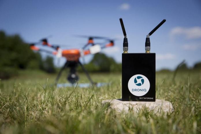
Strategic partnership between Droniq and Sky Drone provides the German drone market with regulated and licensed command & control technology for BVLOS flights of industrial, commercial and governmental use.
Frankfurt-based Droniq and Sky Drone have entered into a strategic partnership that allows Droniq to use Sky Drone’s unique technology for controlling UAS (Unmanned Aerial Systems) remotely in real-time and without any limitation in range. Based on this technology Droniq will offer a complete hardware package for locating, controlling and transmitting data of drones during BVLOS (beyond visual line of sight) flights. This technology is part of the UTM (UAS Traffic Management) system Droniq offers for the German market. That UTM service allows the safe integration of drones into public airspace and provides the basis for broad commercial use of drones over large distances. “Sky Drone perfectly complements the UTM approach of Droniq and is an essential building block for making BVLOS flights reality. We’ve seen the technology being used at several of our customers in Germany and are absolutely convinced of Sky Drone’s technology and their pragmatic mentality.” said Ralph Schepp, COO of Droniq.
As an exclusive partner of Sky Drone in Germany, Droniq is now able to provide real-time communication for drones during their flights. By using the 4G/LTE network of Deutsche Telekom, real-time command and control, video, sensor and telemetry data can be transferred with low latency from the drone to the ground control station and vice versa. This technology complements Droniq’s LTE-tracking module “HOD4track” (Hook-On-Device), which sends its position every second via the mobile network to the UTM system. That device also receives signals from helicopters, gliders and small aircraft in the vicinity and sends those to the UTM as well. That way the drone pilot is always apprised of the situation in his airspace. Furthermore, the HOD4track broadcasts its own position so that other aircraft in the vicinity see the drone right in their cockpit.
The CE-conform product “HOD4command” extends Droniq’s offering by adding real-time communication with the drone over unlimited distances. It can be mounted onto any aircraft and integrates seamlessly into all supported autopilots. The drone therefore becomes controllable over long distances. The data communication is end-to-end encrypted and therefore protected from unauthorized access. The Sky Drone technology the HOD4command is based upon, is already in use in Africa and Europe helping deliver medicine and vaccines to hard-to-reach villages. In Germany it is used for intersite logistics of a large pharmaceutical company. The structurally identical product “HOD4stream” is available with a larger data plan that allows real-time transmission of video, sensor and telemetry data. In industrial applications like maintenance and inspection of pipes and routes as well as in industrial facilities, data can be transferred and analyzed in real-time. First responders already use this technology for remote situational awareness.
“Droniq is the ideal partner for our real-time communication system for drones that’s already being used across the globe. Their reach in Germany and Europe allows the efficient use as well as safe integration of drones into the public airspace.” said Boris Boege, CEO of Sky Drone.
About SKY DRONE: Sky Drone was established in 2012 as the UAV division of Skylab Mobilesystems Ltd. to create real-time communication technology for drones. Their latest Sky Drone FPV 3, Link 3 and 4G/LTE Upgrade for Yuneec H520 products provide a bi-directional low latency data link for command & control as well as a real-time Full-HD video link to a ground control station. Sky Drone’s customers include Intel, Vodafone, Amazon, Wingcopter, European Space Agency, NASA, the Fraunhofer Institute, Federal Criminal Police Office (BKA) as well as many others. www.skydrone.aero
By PRESS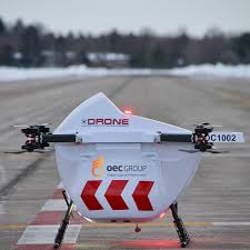
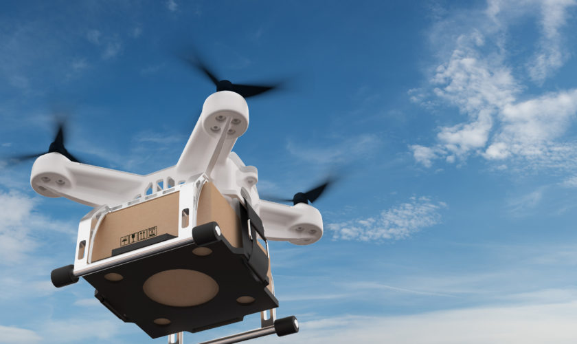
Toronto-based Drone Delivery Canada is partnering with a non-profit to deploy COVID-related drone delivery to a First Nation community.
The company announced a collaboration with GlobalMedic and Air Canada to carry needed cargo to Christian Island, a remote territory governed by the Beausoleil First Nation Community in Ontario. Using Sparrow drones and DDC’s DroneSpot takeoff and landing zones as well as additional drone flight infrastructure, flights will be remotely monitored by the company from its new commercial operations center located in Vaughan, Ont.
Company officials expect the program will launch in the third quarter of this year. The program will work in partnership with logistics firm, the OEC Group.
The Beausoleil First Nation Community is expected to use DDC’s Sparrow drone solution to limit person-to-person contact on its island ferry service by transporting COVID-related cargo such as personal protection equipment, hygiene kits, test kits and test swabs.
“We are pleased to announce GlobalMedic as another paid commercial drone logistics customer,” DDC CEO Michael Zahra said.
He added:
“The Beausoleil First Nation community will benefit from our drone delivery solution during the COVID-19 pandemic by limiting person-to-person contact between the mainland and Christian Island, while keeping their supply chain open. Our solution is ideal for this application and we look forward to seeing the benefits for the Community. To our knowledge this is the first announced [COVID-related drone delivery] logistics project working with a humanitarian aid agency in Canada. We are grateful to GlobalMedic, OEC Group and other generous donors for their sincere concern for First Nations communities, involvement in this project and embracing our drone technology as a solution.”
“GlobalMedic is proud to be part of this [COVID-related drone delivery] program to deliver desperately needed aid to an isolated First Nations Community,” GlobalMedic executive director Rahul Singh said.
“Through consultation with the Community, we understand that supply chain issues exist and have been exacerbated by COVID19. We are excited to use drones as part of the solution to overcome these challenges. We have a well-known history of using drones to respond to crisis zones having deployed our drone teams to dozens of countries using our award winning RescUAV program. We thank the OEC group and other donors to help fund this project and look forward to seeing DDC drones in the air delivering lifesaving aid to our friends in Beausoleil First Nation.”
Last year, DDC partnered with Air Canada and the Edmonton International Airport to launch the world’s first airport-based, drone-delivery hub. Edmonton Regional Airports Authority and DDC plan to build flight routes from EIA using the drone firm’s DroneSpot takeoff and landing zones utilizing DDC’s drone flight infrastructure
By Jason Reagan, Drone Life
There was likely a lively debrief after a Royal Canadian Mounted Police (RCMP) AS350 B3 helicopter and an RCMP SkyRanger R60 surveillance drone collided while on a joint mission over a rural area of British Columbia in February. Although the incident happened in February, it didn’t make it to the Civil Aviation Daily Occurrence Reporting System (CADORS), Transport Canada’s daily list of tragedies, mishaps and oopsies, until June 3. This one rated five on a scale of six by Canada’s Transportation Safety Board in terms of seriousness and was classified as a “midair collision” that resulted in a “forced landing.” The details are perhaps a little more mundane but they do possibly paint a picture of the perils of putting manned and unmanned aircraft in close proximity even when they’re playing for the same team.
The drone was one of two involved in a “policing activities” with the helicopter about 15 miles from the small city of Houston in central B.C. The nature of the operation wasn’t described in the typically clipped CADORS report. The helicopter and drone came together at about 300 feet AGL. After obliterating the drone, the helicopter exhibited a brief vibration and the pilot headed for a clear spot on a road below. The precautionary landing was uneventful and none of the three people onboard was hurt.
Whatever caused the miscue, it was an expensive lesson according to the CADORS report. “Maintenance staff found damage primarily to the main rotor blades along with superficial damage on the tail boom and tail rotor,” the report said. “The [a]ffected components were removed as per the maintenance manual for repairs or overhaul as required. The RPAS was destroyed.” The drone is popular among police departments and was made by Aeryon Systems. List price is about $100,000. The CADORS report said it weighed about six pounds but the manufacturer says it’s more like 10 pounds.
By Russ Niles, Aviation News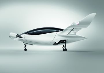
The Lilium Jet
Source: LiliumA German startup that’s making an all-electric vertical takeoff and landing passenger jet became a billion-dollar “unicorn” after raising $35 million from Baillie Gifford & Co., the largest investor in Tesla Inc. after its billionaire owner Elon Musk.
Lilium’s new funding came with a post-money valuation of more than a billion dollars, according a person familiar with the situation, who asked not to be identified as the details are private.
The new money brings the startup’s total investment to date to more than $375 million, the company said in a statement Tuesday.
“The funds raised during this round give us the security to weather the challenging economic landscape we see around us and we’re grateful to be able to stay fully focused on our mission,” Lilium Chief Financial Officer Christopher Delbrueck said.
Co-founded in 2015 by four engineers, Daniel Wiegand, Sebastian Born, Matthias Meiner and Patrick Nathen, Munich-based Lilium employs more than 450 people and will continue to grow with additional hires, said Wiegand, who’s also the firm’s chief executive officer.
He added that the company’s mission since inception has been to create a transportation system that’s accessible to everyone and not just to be used as a toy for the rich.
Existing investors in Lilium include Atomico, Tencent Holdings Ltd and Freigeist.
By Sarah Syed
The US Air Force will pit an advanced autonomous aircraft against a piloted plane in a challenge set for July 2021.
The project could eventually lead to unpiloted fighter aircraft that use artificial intelligence (AI).
Lt Gen Jack Shanahan, head of the Pentagon's Joint Artificial Intelligence Center , called the test a "bold, bold idea".
Air Force Magazine also described the development of autonomous fighter jets as a "big Moonshot" for the military.
At a briefing organised by the Mitchell Institute for Aerospace Studies, Lt Gen Shanahan said he had exchanged emails last weekend with the team leader on the project, Dr Steve Rogers of the Air Force Research Laboratory (AFRL).
He said the AFRL team would attempt to field "an autonomous system to go up against a human, manned system in some sort of air-to-air".
Shanahan said that, at this stage, it may not use "a lot of AI", but in time, humans and machines working together would make a "big difference".
'Swarm' of drones
When announced in 2018, the project envisioned the development of an unpiloted fighter jet.
Asked by Air Force Magazine whether this was still the objective, Lt Gen Shanahan said he did not know but added that AI-enabled systems could be used in other ways.
"Maybe I shouldn't be thinking about a 65ft-wingspan, maybe it is a small autonomous swarming capability," he explained.
Such swarms of drone aircraft could be deployed under a pilot's control or operate autonomously. A US military project called Skyborg will explore how the pilot of a fighter jet could control other drone aircraft - which would act as airborne sidekicks.

These projects feed into an ongoing effort to explore ways of using artificial intelligence (AI) to enhance the American military's capabilities.
But Shahahan said legacy systems would not "go away overnight" and that it was a question of finding a balance and using AI where it could make things more efficient.
"The last thing I would claim is that carriers and fighters and satellites are going away in the next couple of years," he said.
Earlier this year, Elon Musk also entered the discussion, telling the audience at a military conference in Orlando, Florida, that the "fighter-jet era has passed".
Mr Musk said the F-35 fighter jet's competition should be a drone, remotely-controlled by a human with manoeuvres augmented by autonomy.
"The F-35 would have no chance against it," he tweeted.
Lt Gen Shanahan said that the military should be absorbing the best lessons from work on autonomous cars in the commercial sector.
But he warned that among manufacturers, 10 companies spending $13-17bn on research over the last decade had still not developed a Level 4 autonomous vehicle.
Level 4 vehicles are those that no longer require a human driver's attention for safety.
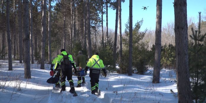
Ottawa, CA: Kongsberg Geospatial, developer of the TerraLens Geospatial SDK, and Larus Technologies of Ottawa, Canada, and the Civil Air Search and Rescue Association of Canada (CASARA), announced today that they have been selected by Public Safety Canada to integrate geospatial software, artificial intelligence, and machine vision software to help develop new methods for the use of drones in search and rescue operations in remote communities in Canada.
Kongsberg Geospatial, Larus Technologies and CASARA are working on a new project funded by Public Safety Canada to develop new procedures for using UAS to assist Search and Rescue efforts in remote communities in Canada
The project will be funded by the Search and Rescue New Initiatives Fund (SARNIF), and has been dubbed OVERSEE – an acronym for “Optical Vision Enhancement and Refinement of Sensor Exploitation Effectiveness”. The OVERSEE project is intended to help address the unique challenges of conducting search and rescue operations in remote areas (such as indigenous communities in the Arctic and their immediate surrounding area) with UAS platforms.
OVERSEE will initially employ available search and rescue statistics from the Department of National Defence, CASARA, Transport Canada and other agencies and execute simulations driven by Artificial Intelligence. The AI will use Deep Learning techniques to investigate how BVLOS regulation effects SAR efforts that make use of drones, and how drones have been integrated most effectively in search and rescue operations, particularly for isolated indigenous communities in Canada’s North that don’t have quick access to Aeronautical search and rescue assets.
Ultimately the goal of this research is to help CASARA members and GSAR (Ground Search and Rescue) workers use BVLOS drones more effectively in search and rescue operations.
Kongsberg Geospatial will be leading the project, contributing their expertise in precision mapping, Air Traffic Management, and the development of multi-vehicle UAS control stations for BVLOS missions to help develop tools and procedures for the safe, effective use of drones for search and rescue missions in remote areas. They will also be contributing tools and training for machine vision techniques.
Larus Technologies specializes in Intelligence Surveillance and Reconnaissance (ISR) systems for defence applications, and will be contributing their Total::Perception™ simulation engine and Total::Vision™ computer vision technology to the project.
CASARA will be helping to gather drone video from training exercises throughout Canada in cooperation with its volunteers, as well as search and rescue event statistics from community organizations. Upon completion of the project, CASARA membership will help to circulate the SOPs derived from the project to their membership of Civil Air Search and Rescue workers and volunteers across Canada to ensure that everyone has access to the improved UAS SAR guidance.
While the project is primarily funded through Public Safety Canada’s SARNIF fund, all three partners will be making in-kind contributions in software licenses, technology, and professional services.
“I feel that this initiative by Kongsberg Geospatial has the potential to enhance our organization’s ability to provide timely and effective SAR (Search and Rescue) assistance”, said Frank Schuurmans, President of CASARA. “We look forward to working closely with Kongsberg Geospatial, Larus Technologies and DND on this project by providing SAR consultation for all requested phases, providing information and research dissemination through our existing communication channels, and by seeking volunteers from within our organization to participate in Computer Vision training activities.”
Kongsberg Geospatial president, Ranald McGillis, said that the project team hopes to help make a meaningful contribution to search and rescue operations in remote and aboriginal communities. “We and our partners believe that this project can help search and rescue volunteers save lives in isolated communities by using inexpensive, off-the-shelf drones to conduct searches until the Canadian Air Force or other aeronautical assets can join the search. We also hope to increase survival rates by showcasing how drone systems can be augmented with Computer Vision systems for improved performance.”
The OVERSEE project is expected to be completed some time in 2021.
About Kongsberg Geospatial: Based in Ottawa, Canada, Kongsberg Geospatial creates precision real-time software for mapping, geospatial visualization, and situational awareness. The Company’s products are primarily deployed in solutions for air-traffic control, Command and Control, and air defense. Over nearly three decades of providing dependable performance under extreme conditions, Kongsberg Geospatial has become the leading geospatial technology provider for mission-critical applications where lives are on the line. Kongsberg Geospatial is a subsidiary of Kongsberg Defence & Aerospace.
By PRESS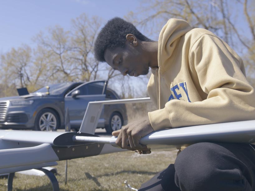
Electrical engineering student Alex Coutu has been part of the Ryerson Unmanned Aerial Vehicles team, external link (RUAV) for three years and is now team captain. When COVID-19 ground everything to a halt, Coutu and the team knew they had an opportunity to take initiative and use their resources to help with relief efforts.
The team is developing a long-range drone that has the capability to travel up to 200 kilometres and carry a load of 15 pounds. The goal is to use the drone to provide vital COVID-19 supplies, test kits and medical necessities to remote communities who are currently underserved.
“We have the knowledge and skillset to build these different vehicles at an industry standard,” said Coutu. “Given our position, and what we’re able to do, it’s really important for us to have as much of a social impact as we possibly can. It’s fulfilling for us as a team to serve communities that are in need.”
The drone designed by the RUAV team was refined over the past year, while Coutu worked out of the Design Fabrication Zone. While the design is in the early stages of testing, the team hopes to get approval from Transport Canada to fly the drone. It will be considered an aircraft with a pilot in control, who acts remotely, flying necessities to communities in Northern Canada, for example, from as far away as Toronto. Coutu and the RUAV team have been safely testing the capabilities of their aircraft design during COVID-19 by making short test flights.
“We really believe that we can help those who lack access to necessary goods in the best possible manner,” said Coutu, who is graduating this spring with a degree in electrical engineering and will continue working in the Design Fabrication Zone this fall.
The RUAV team is made up of students across multiple faculties. Team members are currently in business and engineering streams like marketing, commerce, mechatronics, aerospace, and electrical.
The coronavirus pandemic has caused a significant increase in the number of drone delivery programmes that have been implemented and trialled across the UK and beyond.
Goldman Sachs recently reported that the global drone market could hit £80 billion if uses such as takeaway food delivery, border patrol and infrastructure surveillance are to continue their growth and become widespread.
In particular during the outbreak of COVID-19, drones have been used for the delivering of food and medical supplies to vulnerable persons in remote locations
The technology is also being utilised by the healthcare industry to transport test samples and medical supplies between facilities.
The Isle of Mull became the latest location in the UK to trial such a system, with Argyll and Bute Health and Social Care Partnership bringing in Thales and Skyports to provide the delivery of urgent medical cargo, including PPE.
Data-drive drone insurance provider flock insured the project, with CEO Ed Leon Klinger commenting: “A few years ago drone deliveries were no more than science fiction. Today they’re taking place around the world, helping to transport critical equipment like PPE and medication.”
Outside of the UK, drone deliveries for both medical and commercial purposes in Ireland, Canada, the United States and the rest of the world have grown in frequency in recent months, both before and since the coronavirus pandemic took hold.
By SAM LEWIS
Racing to beat the clock, first responders in Minot, North Dakota, tap one of the world’s top drone providers in successful rescue effort.
When a child goes missing, the first 48 hours are critical—but they are also the most stressful and chaotic.
Family members often start the clock ticking by looking in spaces where a child may typically crawl or hide: in a closet or pile of laundry, under a bed or inside a vehicle. By the time law enforcement is notified, there’s not a minute to spare. Search teams must be assembled and cover a wide area as quickly as possible.
That’s why, when a small child was reported missing in Minot, N.D. on April 26, 2020, the City of Minot Police Chief John Klug turned to SkySkopes headquartered nearby in Grand Forks and named one of the top five Drone Service Providers (DSP) in the world by Frost & Sullivan.
“We’ve conducted numerous training scenarios to use drones to find missing people, and these agencies were familiar with our search-and-rescue capabilities,” said SkySkopes CEO Matt Dunlevy. “While our drones were extremely useful, it was all due to the swift actions taken by the Minot Police Department and the Minot Fire Department that the child was found safe within just a few hours.”
Locating a missing child by process of elimination
SkySkopes has long been a trusted DSP for clients in industries such as energy, utilities, transportation and oil & gas. An innovator testing state-of-the-art drone technology and services, SkySkopes was the first company to operate under FAA (Federal Aviation Administration) waivers to fly both beyond visual line of sight and over people, which allowed them to operate in a populated area where the search took place.
Within 20 minutes of receiving the call, SkySkopes had teams on site and ready to take flight.
“When Chief Klug contacted us, we knew what to do to rapidly secure airspace permissions,” said Dunlevy. “We also had the personal protective equipment necessary to ensure our pilots and teams met COVID-19 standards, as the pandemic was happening simultaneously.”
Equipped with the most advanced, commercially available cameras, optical gas imaging (OGI) and thermal sensors, SkySkopes provided an aerial view that, through process of elimination, could show in real time where the child was or was not. This ultimately aided first responders in quickly narrowing the search and pinpointing the child’s exact location, which in this case was a neighbor’s house where the child was peacefully napping.

Responding to an emergency within an emergency—with Skyward
Since 2014, SkySkopes has been relying on Skyward, a Verizon company that’s developing the future of drone connectivity. Skyward helps SkySkopes manage its entire unmanned aerial services (UAS) program, from teams and equipment to projects, flights and aviation regulations.
“We have complete confidence in Skyward’s ability to help mitigate many of the operational challenges of search-and-rescue emergency response operations,” added Dunlevy. “In addition to rapid airspace access, Skyward offers situational awareness of our crews and assets. It also helps reduce time and cost of operations, making sure we are as efficient as possible—and that we’re socially responsible in ensuring our drone pilots are operating safely, even in the middle of a pandemic.”
Supporting our nation’s efforts to find missing children
Helping the National Center for Missing and Exploited Children (NCMEC), Verizon proudly provides donated media to support NCMEC’s essential work fighting online child exploitation, aiding victims and finding missing kids. In this year alone, Verizon will donate more than $1 million in online advertising that will be used by NCMEC to help find critically endangered, missing children.
By PRESS