User blog: Bruce McPherson
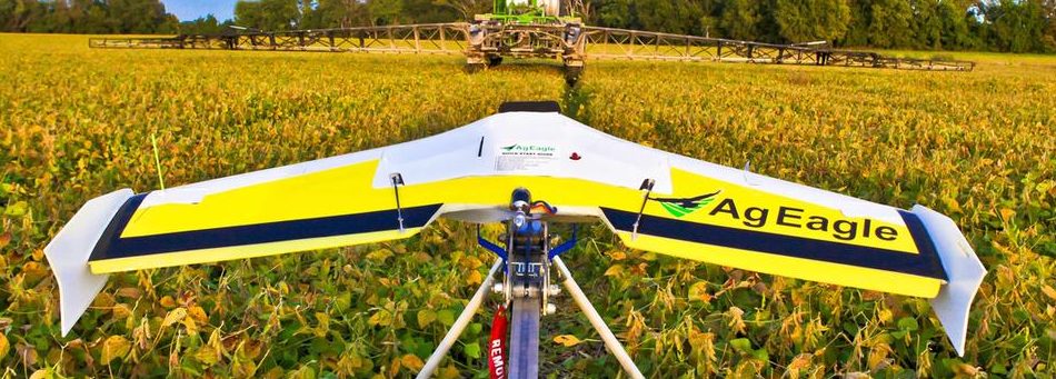
AgEagle Aerial Systems Inc. (NYSE American: UAVS) (“AgEagle” or the “Company”), an industry-leading provider of drones, sensors and software, today announced its financial results for the second quarter reporting period ended June 30, 2021.
Commenting on the results, Brandon Torres Declet, AgEagle’s Chief Executive Officer, stated, “Our strong second quarter results reflect our successful execution and emboldens our resolve to build enduring, long-term shareholder value by remaining focused on research and development, building internal talent and collaboration across our brands, and driving the implementation of growth strategies aimed at bringing innovative new solutions to global enterprises. Delivering high performance, full stack, drone solutions to a broad range of industries, including energy, construction, agriculture and government, it is our firm belief that AgEagle can positively disrupt and help to transform how businesses within these verticals operate.”
Financial Highlights for the Three-Months Ended June 30, 2021, and 2020
- Revenues rose significantly to $1.94 million from approximately $16,000 due primarily to new revenue contribution from MicaSense, acquired by AgEagle in late January 2021, and Measure Global (“Measure”), acquired by the Company in mid-April 2021. Revenue growth was also positively impacted by increased sales of our HempOverview platform to the State of Iowa and Florida.
- Second quarter revenues by segment were as follows: sensor sales totaled $1.71 million, software subscription sales totaled $173,000 and drone and custom manufacturing sales totaled $60,000.
- Gross profit margin improved to 50% from 8% largely because of the Company’s strategy to expand its mix of product offerings through the acquisitions of MicaSense and Measure.
- Net loss declined to $4.68 million, or $0.07 loss per share, for the second quarter of 2021. This compared to a net loss – after factoring non-cash charges of $9.07 million associated with the Company’s financing activities in the second quarter of 2020 – of $10.33 million, or $0.31 loss per share.
Financial Highlights for the Six-Months Ended June 30, 2021, and 2020
- For the first six months of 2021, revenues climbed nearly 800% to $3.64 million, up from revenues of $408,000 for the comparable six months in 2020. The increase was attributable to strong sensor sales by MicaSense, coupled with new revenue contribution from Measure. Revenue was also positively impacted by increased sales of the Company’s HempOverview™ platform.
- Revenues by segment for the six months ended June 30, 2021, were as follows: sensor sales totaled $3.38 million, software subscription sales were $196,000 and drone and custom manufacturing sales totaled $60,000.
- Gross profit margin remained unchanged at 54% on compared to prior year period,
- Net loss declined to $7.61 million, or $0.21 loss per share, for the first half of 2021, compared to a net loss of $10.77 million, or $0.44 loss per share, for the first six months of 2020.
- As of June 30, 2021, the Company’s cash position was $39.21 million, compared to $23.94 million cash on hand as of December 31, 2020.
Second Quarter 2021 Operational Highlights
- In mid-April, AgEagle completed its acquisition of Measure, an award-winning aerial intelligence solutions company, in a cash and stock transaction valued at approximately $45 million. Shortly thereafter, Measure co-founder and CEO, Brandon Torres Declet, was named as Chief Operating Officer of AgEagle and appointed as an executive member of the Company’s Board of Directors. In late May, the Board named Declet as AgEagle’s new Chief Executive Officer, replacing the Company’s former CEO.
- In late May, AgEagle entered into an at-the-market sales agreement with Stifel, Nicolaus & Company and Raymond James, under which the Company may sell its common stock, from time to time, for up to $100 million in aggregate sales proceeds in “at the market” transactions. During the month of June, the Company sold 5,271,100 shares of common stock at a stock price between $5.02 and $6.30 per share, raising net proceeds of $28.65 million.
- AgEagle announced the integration of Measure’s Ground Control software with Parrot’s ANAFI, ANAFI USA and ANAFI Thermal drone platforms, thereby providing enterprise customers with a world-class, end-to-end solution for readily managing and scaling drone fleet operation workflows.
- In June, AgEagle was added to the Russell 2000® Index following the conclusion of the 2021 Russell Indexes annual reconstitution.
- Measure’s Ground Control was certified SOC2 compliant by Lindford & Company after an extensive audit, allowing the software to be sold to the largest companies in the world with the strictest cybersecurity requirements.
- The Florida Department of Agriculture and Consumer Services (FDACS) expanded its licensing of AgEagle’s HempOverview™ SaaS platform, enabling FDACS to leverage the full breadth and power of HempOverview to manage hemp farming registration, real-time best management practices, oversight and enforcement and reporting functions. In addition, FDACS contracted with AgEagle to develop a custom registration software platform to enhance communications, licensing and general compliance relating to the oversight and protection of more than 500 endangered and commercially exploited wild plants native to the state of Florida.
- MicaSense launched a comprehensive outreach effort to its value-added-resellers (VARs) worldwide in an effort to garner increased sales and support for its proprietary sensors, including the Altum™, RedEdge-MX™ and RedEdge-MX™ Blue. MicaSense has global distribution in over 70 countries.
Continuing, Declet said, “We have made significant strides operationally over the past several months, increasing our confidence in our plan to continue investing in the design and development of true leading-edge drones, sensors and software solutions capable of providing our customers with material cost-saving efficiencies, data-backed actionable intelligence and enhanced safety and security for their workforces and worksites. We’ve also recently added key leadership roles to our growing team and are actively seeking many more talented and motivated professionals to join our organization and purpose-driven culture.”
“Looking ahead, we intend to continue to invest in our own innovations, pioneering new and enhanced products and solutions that enable us to exceed the expectations of our customers and support our ecosystem of partners and, most specifically, our value-added-resellers (VARs). Moreover, through our active advocacy efforts and direct involvement with government- and industry-sponsored agencies and organizations, we believe our Company will remain at the forefront of shaping the rulemaking guidelines and regulations that will help to make autonomous flight of unmanned aerial systems safe, reliable, and accessible to more businesses worldwide,” concluded Declet.
For more detailed information on AgEagle’s second quarter financial results, please view the related Quarterly Report on Form 10-Q filed with the U.S. Securities and Exchange Commission and available at www.sec.gov.
Corporate Update Conference Call and Webcast:
As a reminder, AgEagle’s leadership team will host a live conference call and webcast today, beginning at 11:00 AM Eastern Time. The corporate update will be broadcast live and available for replay here or via AgEagle’s website at https://ageagle.com/events/ shortly after the call concludes.
About AgEagle Aerial Systems Inc.
Founded in 2010, AgEagle is one of the nation’s leading commercial drone technology providers. AgEagle’s mission is to empower The Drone Age™ by providing American-made drone solutions to the world. The Company is leveraging its reputation as one of the industry’s premium technology solutions and aerial data intelligence providers to deliver high performance, end-to-end drone solutions for commercial use worldwide. AgEagle products are proudly manufactured and assembled in the United States. For additional information, please visit our websites at www.ageagle.com, www.measure.com and www.micasense.com.
By PRESS
UK Research and Innovation (UKRI), the UK’s research and innovation agency, has set out its vision for the future of air travel in Britain.
Compiled by leading experts from industry, academia and government, the Future Flight Vision and Roadmap sets out how zero emission air travel within and between British cities could be commonplace within a decade.
UKRI’s Future Flight Deputy Challenge Director Simon Masters said,
“Achieving accessible, safe, sustainable transport will be a key element in the fight against climate change. That’s why in the year of COP26, UKRI is setting out what it thinks air travel should look like in 2030.
“Some of the concepts in this roadmap might seem a little further away than 2030, but the future is closer than you think. We’re already seeing some these ideas put into practice, with the UK’s first vertical takeoff airport months from opening and a hybrid air travel trial taking place in Scotland at this very moment.”
LOWER CONGESTION, LOWER EMISSIONS
One of the key elements of the roadmap is the use of hydrogen or electrically powered aircraft to provide short journeys for up to 10 people. These vertical-takeoff air taxis would eliminate carbon emissions, ease congestion in British cities and reduce journey times for travelers.
The same is true of the increased use of drones by emergency services and for delivering goods. These will provide rapid and convenient access to everyday goods and services, while also supporting emergency services in undertaking complex inspections and operations.
Also in the roadmap are sustainably powered small aircraft to provide short regional flights, providing transportation between towns and cities and serving more remote communities. These would then link in with other transport modes within a city, allowing for a seamless, end to end travel experience.
CURRENT DEVELOPMENTS
The publication of the roadmap comes as aviation company Ampaire launches a week of hybrid electric light aircraft flight trials. The company, who are part of the UKRI-funded Sustainable Aviation Test Environment (SATE) project, recently undertook a demonstration flight where one of their hybrid electric EEL aircrafts completed a 30-minute journey from Kirkwall in the Orkney Isles to Wick airport in the North of Scotland.
Over in Coventry as part of its 2021 City of Culture programme the Air-One project, led by Urban-Air Port and supported by Coventry City Council is working on setting up the world’s smallest airport. Specifically designed to support electric vertical take off and landing aircraft this pop-up airport can be deployed in days, in an area 60% smaller than a standard helipad and with minimal impact on the environment.
FURTHER INFORMATION
About the Future Flight Challenge
The aviation system of the future needs more than just aircraft. The world is shaping up for a third revolution in aviation, one that sees greener, more flexible ways to fly. The Future Flight Challenge is a £300 million programme designed to secure the UK’s position at the front of the revolution.
The Challenge aims to transform how we connect people, deliver goods and provide services by speeding up the acceptance of these innovative ways and bringing them into use safely and practically. By combining control and regulation with infrastructure and aircraft systems to create new operating models the Challenge is creating the aviation system of the future.
For more information, go to Future flight challenge – UKRI.
About UK Research and Innovation
UK Research and Innovation (UKRI) is the largest public funder of research and innovation in the UK, with a budget of around £8bn. It is composed of seven disciplinary research councils, Innovate UK and Research England.
We operate across the whole country and work with our many partners in higher education, research organisations businesses, government, and charities.
Our vision is for an outstanding research and innovation system in the UK that gives everyone the opportunity to contribute and to benefit, enriching lives locally, nationally and internationally.
Our mission is to convene, catalyse and invest in close collaboration with others to build a thriving, inclusive research and innovation system that connects discovery to prosperity and public good.
About Industrial Strategy Challenge Fund
The Industrial Strategy Challenge Fund aims to bring together the UK’s world leading research with business to meet the major industrial and societal challenges of our time.
The fund was created to provide funding and support to UK businesses and researchers, part of the government’s £4.7 billion increase in research and development over the next 4 years.
It was designed to ensure that research and innovation takes centre stage in the Government’s modern Industrial Strategy. It is run by UK Research and Innovation.
About SATE
SATE is the UK’s first operationally based aviation test centre based at Kirkwall Airport in Orkney. Launched as part of UKRI’s Future Flight Challenge which supports the development of greener ways to fly, the project will test different types of low-carbon aircraft to identify the next generation of air services as well as the operational airport infrastructure necessary to support sustainable aviation.
SATE will also address the challenge to improve UK regional air connectivity and helping to decarbonise the Highlands and Islands region, the innovative project will stimulate job creation and use local renewable energy, supporting Orkney’s net-zero ambitions.
Led by Highlands and Islands Airports Limited, the SATE project brings together an international consortium of 13 partners including aviation industry specialists, local Orkney and Caithness businesses, public sector bodies and academia.
About Ampaire
Ampaire Inc. is leading the charge in aircraft electrification. The Los Angeles-based company’s mission is to be the world’s most trusted developer of practical and compelling electric aircraft. To start, the company is upgrading existing passenger aircraft to electric power—the quickest and most capital efficient approach to making commercial electric air travel a reality. Ampaire Ltd. is the subsidiary company. For more information, visit www.ampaire.com.
By PRESS
Residents of a remote Alaska coastal community will fly unmanned aircraft systems to support the Coast Guard’s oil spill response, fuel tank inspection, and search and rescue efforts.
The project, supported by the University of Alaska Fairbanks, will also provide data to enhance local decision-making on environmental and community issues.
Seven residents of Unalakleet, about 150 miles across Norton Sound from Nome, are participating in the program run by Jessica Garron, an affiliated researcher with the Alaska Center for Unmanned Aircraft Systems Integration at the UAF Geophysical Institute. Garron is a research assistant professor in the International Arctic Research Center at UAF.
“There is a disconnect between what the Coast Guard can do in Alaska in a spill response type of environment,” Garron said. “One of those problems is a 24- to 48-hour lag time in getting response teams into rural Alaska.
“This project is working to train a workforce to provide situational awareness during emergency response events,” she said, “as well as to support the Coast Guard’s mission of performing bulk fuel storage inspections while simultaneously providing workforce development opportunities in support of localized, science-based decision-making.”
The unmanned aircraft systems, or UAS, project runs through April 2022 and is funded by the Arctic Domain Awareness Center, a Center of Excellence in the U.S. Department of Homeland Security.
The UAS project was born from a program initiated by the Native Village of Unalakleet. In 2018 the group received funding from the Bureau of Indian Affairs’ Tribal Resilience and Ocean and Coastal Management and Planning Program to assess the use of unmanned aircraft systems and online tools to improve local decision-making.
That program was led by John Henry Jr., deputy director of the Native Village of Unalakleet; Margaret Hall, associate director of the national nonprofit Model Forest Policy Program; and Garron. Henry, who is joining six other Unalakleet residents in the training, and Hall are co-investigators in the project.
Henry said the BIA grant funding had two elements.
“One was to address future climate-related ocean and coastal management planning challenges that tribes may incur, and the second is to build long-term resilience through the establishment of a self-sustaining, localized and ongoing data collection and analysis program.”
To do so, the project team chose nine scientific study areas to assess based on Henry’s local insight: coastal erosion, river and sea flood preparation, infrastructure, water quality, air quality, cultural and historical site identification, extractable resources, wildlife, and plant community.
Unmanned aircraft were seen as useful for supporting local decision making in several of those areas.
“The unmanned aircraft systems might be able to offer the ability to build on the traditional ecological knowledge that is passed on by elders and other members of the community,” Hall said.
“This project is also hopefully an economic development opportunity for some of the members of the Norton Sound area, especially Unalakleet at this time,” she said. She noted that other Native villages in the region such as Elim, Shaktoolik and Golovin could eventually choose to pursue their own program or participate in this current one, if expanded in the future.
One major area in which the program can benefit the region is the detection and response to an oil spill, Hall said. The Norton Bay Intertribal Watershed Council has expressed concerns about heightened potential for spills as marine traffic increases year-round due to continuing declines in annual sea ice and about the emergency response time to an incident. Oil spills in the Bering Strait are also of increasing concern to the Coast Guard and other government entities that would be called upon to respond to an oil spill.
The UAS program launched in February, and the participants were selected in March. Each has a background that will prove helpful in the array of potential UAS uses, including environmental monitoring, hazardous materials handling, tank inspection, information technology and repair work.
The first virtual FAA training for UAS operation occurred in April; the final session occurred in early June. The participants will be taking their Federal Aviation Administration Part 107 certification exam in Anchorage. One participant has already been certified.
Flight protocols for various mission scenarios will be developed over the summer by the Unalakleet pilots, UAF researchers and Coast Guard personnel.
Smaller training aircraft have been procured for initial hands-on work with Garron’s team this fall. Operational aircraft for the program will be purchased in August or September and will be used for data collection flights after completion of hands-on training.
The program’s leaders hope the Unalakleet project can serve as a model and be replicated elsewhere in Alaska and in Coast Guard sectors in the Lower 48.
By PRESS
© Provided by The Canadian Press
TISDALE, Sask. — Mounties say a man is in hot water for landing a helicopter to pick up a cool treat in a Saskatchewan town.
RCMP said in a news release Tuesday that they received a complaint on July 31 that a helicopter had landed in a high-traffic parking lot in Tisdale, which is about 215 kilometres east of Saskatoon.
They said the helicopter blew up dust and debris through the area that includes schools and an aquatic centre.
An investigation determined the landing was not an emergency.
Police said a passenger left the helicopter and went into a nearby Dairy Queen restaurant to buy an ice cream cake.
Officers said the pilot, who is a 34-year-old man from Leroy, Sask., had a licence to fly the helicopter but landed in an illegal spot.
The man, who has not been named, was charged with dangerous operation of an aircraft and is to appear in court next month.
Kiara Broeckel, who works at the Dairy Queen, said store employees didn’t know the customer had arrived by helicopter until the RCMP news release.
Since then, she said town residents have visited to ask if there is going to be another fly by and if the ice cream cakes are really worth a helicopter trip.
“Apparently they are,” said Broeckel. “I wouldn’t think you would take a helicopter to go get ice cream, but I guess some people do."
This report by The Canadian Press was first published on Aug. 11, 2021.
The Canadian Press
Drone Delivery Canada is partnering with the University of British Columbia to deploy delivery drones to the Stellat’en First Nation.
The agreement is part of UBC’s Remote Communities Drone Transportation Initiative and will enable defined-route deliveries using DDC’s Sparrow drone and its DroneSpot takeoff and landing zones to transport cargo to the Stellat’en Village of Fraser Lake, located in Central Northern British Columbia.
A DDC spokesperson said site infrastructure installation would begin later this summer with drone delivery services slated for the second half of this year. The deployment will be DDC’s fourth First Nations project and its first in British Columbia.
“As we transition into a new phase of the COVID-19 pandemic, and with the risk of wildfires, we are looking forward to learning about how this innovative transportation technology can be used to meet community needs and help address inequities in access to health-care supplies and services,” said Dr. Michael Allard, Vice Dean, Health Engagement, UBC Faculty of Medicine.
“Based on the isolated location of our community and the needs of our residents, drone transport may enhance our access to COVID-19 testing and medication without traveling and endangering other members of our community,” said Chief Robert Michell of the Stellat’en First Nation, located about 62 miles west of Prince George. “The futuristic potential of this initiative is exciting. With drone technology, there is so much you can do.”
“The UBC Faculty of Medicine is a recognized global leader and we applaud their initiative to embrace drone delivery to benefit First Nations communities,” DDC CEO Michael Zara said. He added that laboratory diagnostic information and digital health connectivity provider LifeLabs will be supporting the project to ensure an end-to-end solution by participating in data evaluations, sample logistics and training.
Lifesaving drone solutions amid the pandemic
Last year, DDC announced a collaboration with GlobalMedic and Air Canada to deliver COVID-treatment cargo to Christian Island, a remote territory governed by the Beausoleil First Nation Community in Ontario.
The company also launched a partnership with the Georgina Island First Nation to provide delivery services to the Ontario community. A two-way delivery flight route to the First Nation’s mainland community deploys a Sparrow drone and DroneSpot takeoff-and-landing zones.
DDC has also finalized a research agreement with the University of Toronto Institute of Aerospace Studies in cooperation with automaker Ford. The group will test an automated drone as it tracks and lands on a moving ground vehicle within the flight arena. In 2019, DDC signed an agreement brokered by Air Canada to work with Kenyan startup Astral Aerial Solutions Limited to grow the African nation’s drone delivery market.
Just over one month ago, on 24th June 2021, residents in the densely populated area of South Moravia, Czech Republic, had their lives uprooted. They were hit by a natural disaster uncommon on this scale in Europe, a tornado with winds of at least 219km/h (136 mph).
The devastation it caused left thousands of damaged homes behind, and in some cases, destroyed whole city quarters. It flipped cars over, lifting them and throwing them into trees that had managed to stay in place. It created an apocalyptic scene that was unimaginable in a region known for its wine production and unique culture.
When the incident was first reported at 7.23pm, firefighters were immediately dispatched, and from that moment on thousands of professionals and volunteers were on hand to deal with an area of wreckage approximately 26 square kilometers (10 square miles), the equivalent of more than 4,800 football pitches. A total of 2,000 professional firefighters from all over the Czech Republic and approximately the same number of volunteer firefighters, alongside many locals and people offering help, took turns to do their utmost in the affected area. The Fire Rescue Services of the Czech Republic deployed approximately 550 pieces of equipment at the scene.
This was also the very first time that Czech Fire Rescue Services had combined DJI’s drone technology with aerial mapping GINA software.
We asked Col. David Jirous, the head of KOPIS (Operational and Information Centre) of South Moravia, to tell us more…
-Can you describe the scene in your own words?
“It was something unimaginable because tornadoes are very rare in our area. Houses were destroyed, trees uprooted, and debris was left everywhere.”
“In the first phase it was very difficult, there was a lack of forces and resources, but above all, we had very little idea of the size of the affected area. Therefore, drones were subsequently used to map the terrain and create a real-time digital map of the devastated area.”
-What time did you first start using the drone and mapping software?
“The DJI Mavic 2 Enterprise DUAL took off shortly after dawn the following day, when the light conditions allowed us to take images of the devastated landscape.”
-How long have you been using drone technology and GINA software?
“Fire rescue services in the South Moravian Region have been using GINA technology since 2012 and drones since 2018.”
-What benefits do drone technology and GINA software give you that you wouldn’t usually have access to?
“Thanks to the use of drones, we have almost immediately an aerial perspective and digital map of the affected area which is distributed to the GINA app. This is accessed by firefighters in the field and the local command center for an accurate picture of the scene and location tracking. We had an up-to-date overview of the affected area, the amount of damage and the force and resource requirements. Thanks to technology we can react flexibly to altering situations in the field.”
“In general, GINA significantly improves the efficiency of both routine and special operations, reduces arrival time, provides real-time information support, and increases the level of cooperation among all responding units.”
-If you didn’t use aerial technology and GINA software, how long would it usually take you to map an area of this size and how would you do it?
“Considering the size of the affected area (over 26 km), which includes difficult to reach isolated areas, it would be very time-consuming to map by purely ground-based means. We’re talking about days rather than the hours it actually took. If we didn’t use drones, we would have to rely on people reporting back from the area where they were working.”
-Is there any additional information you’d like to give?
“Thanks to the experience gained from mapping areas damaged by tornadoes, we want to apply this knowledge to the project we are currently working on, which focuses on automatic mapping of the marked area in GIS or in GINA Tablet. A unique feature of this project will be the time it takes for the digital map to get to first responders in the field. We would like to distribute the data from the drone to GINA apps in near real time using a fast mobile connection such as 5G and LTE networks, or on a local network.”
By Matt Bailey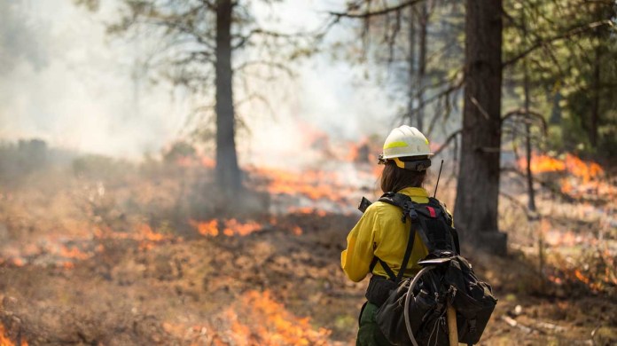
- In the deployment of Verizon Frontline technologies, the Verizon Response Team (VRT) is in the process of certifying 18 drone pilots nationwide, adding aerial search-and-rescue and awareness capabilities.
- Verizon Frontline is the advanced network and technology built for first responders, developed over three decades of partnership with the public safety community.
BASKING RIDGE, N.J. – Verizon Frontline recently announced the launch of a first-of-its-kind unmanned aerial system (UAS), or drone, training program designed to enable members of the Verizon Response Team to support first responders with missions ranging from risk or damage assessment to search and rescue operations.
The program, designed by a Verizon response manager and former U.S. Army air traffic controller, consists of 30 separate blocks of training focused on bringing someone with almost no UAS experience to the point where they can deploy a professional drone in support of active response efforts.
This VRT-specific curriculum goes beyond that required by the Federal Aviation Administration to fly a drone under the FAA’s Small UAS Rule (Part 107). While the VRT program builds on the foundational elements of the FAA’s requirements, prior to being able to deploy their drones, VRT members must first be FAA (Part 107) certified and obtain a Remote Pilot Certificate. This certificate demonstrates an understanding of the regulations, operating requirements, and procedures for safely flying drones.
Currently, 15 out of the 18 members of the VRT have obtained their remote pilot certificate. Nearly a third of the team has completed the additional requirements necessary to be certified through the VRT’s internal training program.
Following completion of the training, Verizon response managers located throughout the country will be able to deploy their drones to help meet the evolving needs of public safety officials and assist in the capture and aggregation of data to help first responders make safe and informed decisions as they respond to events such as hurricanes, wildfires, earthquakes and floods.
This VRT training program, developed with the current needs of public safety professionals in mind, is a continuation of Verizon Public Sector’s commitment to working alongside our partners in public safety and government.
Verizon Frontline is the advanced network and technology built for first responders – developed over nearly three decades of partnership with public safety officials and agencies – to meet their unique needs. From network priority and preemption and a commitment to real interoperability, to developing and delivering the most innovative product roadmap, Verizon Frontline is built on America’s most reliable network1, and will be able to harness the transformative power of 5G.
The VRT provides on-demand, emergency assistance during crisis situations to government agencies, emergency responders, nonprofits and communities on a 24/7/365 basis. VRT members set up portable cell sites, WiFi hotspots, free charging stations and other devices and solutions that enable communications and/or boost network performance.
1 Rankings based on the RootMetrics® US, state, and metro RootScore® Reports: 2H 2013-1H 2021. Tested with best commercially available smartphones on 3 national mobile networks across all available network types. Your experiences may vary. The RootMetrics award is not an endorsement of Verizon.
By PRESS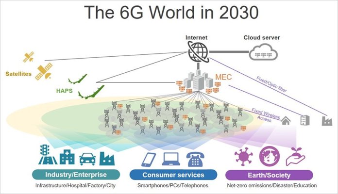
SoftBank Corp. (“SoftBank”) announced its 6G (known as “Beyond 5G” in Japan) concept, as well as the challenges that need to be overcome to make the concept a reality.
On top of enhancing 5G’s features that include ultra-high-speeds, ultra-low latency, and massive device connectivity, 6G is expected to bring new technological innovations, including high reliability and improved energy efficiency. To provide a network infrastructure needed for the 6G era society, SoftBank is taking up the challenge of resolving numerous issues in different areas. Working toward that goal, SoftBank’s current initiatives include expanding into areas where wireless technologies can be utilized for purposes other than telecommunications such as, evolving network architectures where AI can function, ensuring high levels of resiliency so that all businesses can utilize these advancements with peace of mind, and contributing to the realization of a carbon-free society.
Ryuji Wakikawa, SoftBank Corp. Vice President and Head of the Advanced Technology Division, commented as follows:
- -Up to 4G, mobile networks were designed for smartphone usage. After 5G, the advent of 6G will transform mobile networks into network infrastructure that will support the digitalization of all industries. With 6G, every business across Japan will be built on the foundation of mobile networks, just as the Internet became the sole common basic infrastructure for online communications around the world.
- -The Internet will be utilized to build a virtual digital space, with mobile networks connecting base stations and devices. In this way, digital and physical spaces will be connected in real time. What is predicted and judged in the virtual space using AI will be fed back to the physical space with ultra-low latency. Not only will 6G networks serve as communication networks; they will also evolve into computers that support an AI society. Edge computers will be deployed everywhere in Japan, and these computers will be capable of AI and other types of server processing to disperse computing. These computers will establish a high-quality, end-to-end communications environment connected to networks in highly sophisticated ways. If AI is the trigger for the next Industrial Revolution, 6G will be the telecommunications infrastructure that makes it happen.
- -SoftBank started research and development of potential 6G technologies such as High Altitude Platform Stations (HAPS) and terahertz communication back in 2017. By flying base stations in the stratosphere, HAPS systems are capable of receiving and transmitting radio waves over an area stretching as far as 200km in diameter, as well as into the airspace above. As such, HAPS is expected to be a key technology for expanding communication area coverage. We have already successfully completed a communications test in the stratosphere, spearheaded initiatives to standardize HAPS frequency bands, established a global industry alliance, among other achievements. Furthermore, as part of our efforts to expand frequency usage, we are working on the terahertz range beyond millimeter-wave with the aim of applying these frequencies for telecommunications. New possibilities will open for wireless networks to be used at data centers, such as wireless communications between racks and servers, when we achieve telecommunications faster than fiber-optic cables and reach communication speeds in excess of several hundreds of gigabytes per second.
- -We have been working on various research and development projects, always taking the application of mobile communications into consideration while doing so. We are now unveiling some of these technologies for the first time. 6G is playing a key role in SoftBank’s digital platform strategy, and it will support a variety of businesses as a common basic infrastructure, help AI technologies to blossom through the creation of “digital twins,” and make it possible to realize fully customizable communications networks and computer resources. Guided by our corporate philosophy, “Information Revolution – Happiness for everyone,” SoftBank is taking on the challenges to make 6G a reality with the aim of realizing the complete digitalization in Japan.
(1) SLA VS. “BEST-EFFORT”
Until now, services provided on mobile networks that connect smartphones to the Internet have been on a “best-effort” basis because of the nature of the Internet protocol (IP). For example, small network delays or packet loss were unlikely to inconvenience people’s daily lives such as online shopping and video streaming. In the future, however, 6G mobile networks will underpin network infrastructure that supports a variety of industries. SoftBank will accommodate complete end-to-end communication for customers with appropriate Service Level Agreements (SLA) in its network by leveraging Mobile Edge Computing (MEC) and network slicing.
(2) API-DRIVEN NETWORK CUSTOMIZATION
There is no doubt that the Internet has continued to evolve systems and protocols because of its openness. On the other hand, the evolution of mobile networks was limited due to proprietary technologies and a closed culture for a long time. For mobile networks to be a fundamental infrastructure for various industries, they need to be capable of supporting customization and dynamic configuration on the fly. SoftBank will provide more convenient services for customers by incorporating RESTful (Representational State Transfer) application programming interfaces (APIs) to customize and configure its network for customer needs.
(3) AI NETWORKS
AI technologies are now applied to more areas than before, including for the detection of objects using image-recognition technologies, voice recognition/translation, and network optimization/automation operations. However, AI engines require a lot of data and computational resources. The AI engines could be deployed over networks with various rich data handling and unlimited computational resources, instead of having them in devices. To maximize the power of network-based AI, high-speed and low-latency networks are required. By distributing GPUs as well as servers across mobile networks, it will be possible to provide low-cost, high-quality networks and AI services. These GPU resources could also be used to automate SoftBank’s network operations with AI intelligence as well. SoftBank has been conducting technological verifications of virtual base stations equipped with GPUs since 2019. SoftBank’s network will be adjusted to network traffic patterns, customer behavior and network demands automatically by AI.
(4) 100% COVERAGE
6G networks will require the elimination of dead spots where people live and total coverage around the globe. SoftBank aims to solve these challenges by offering Non-Terrestrial Network (NTN) solutions that utilize HAPS and Low Earth Orbit (LEO) and Geosynchronous Earth Orbiting (GEO) satellites. This will enable SoftBank to offer Internet services to more than three billion people around the world who are currently unable to access the Internet. It will also allow mobile network access at sea, in mountainous areas and the upper atmosphere, where the installation of base stations has been impossible to date. As the underlying infrastructure, 6G networks will pave the way for new industries that enable autonomous driving, flying taxis and drone-based delivery services, among others.
(5) AREA EXPANSION BY HAPS
HAPSMobile Inc., a subsidiary of SoftBank, has been developing stratospheric telecommunication platform systems since 2017. In 2020, the company successfully demonstrated a stratospheric flight and long-term evolution (LTE) communications from the stratosphere in New Mexico, USA. “Sunglider,” an unmanned aircraft system equipped with solar panels, was used as the stratospheric communications platform for the test. The successfully test proved the feasibility of SoftBank’s High Altitude Platform Station (HAPS) technology. Utilizing the large amount of data obtained from the test flight, SoftBank is developing aircraft systems and wireless equipment with a view to commercialization and preparing to meet regulatory requirements.
(6) BEYOND MILLIMETER-WAVE: TERAHERTZ AND OPTICAL COMMUNICATION
5G technologies made it possible to use millimeter-wave frequencies that had remained an untapped resource in mobile communications previously. For 6G, the terahertz range, frequencies higher than millimeter-wave, such as terahertz and optical range, will be exploited to construct networks that operate at ten times the speed of their 5G counterparts. Frequencies ranging from 100GHz to 10THz are generally regarded as being in the terahertz range. The World Radiocommunication Conference 2019 (WRC-19) set aside a total of 137GHz for telecommunications use among frequencies above 275GHz that had never been allocated previously. By exploiting this vast range of frequencies for mobile communications, SoftBank’s aim is to achieve even-faster speeds and ever-larger volume communications.
(7) SENSING AND POSITIONING
Mobile operators have utilized radio spectrum just for telecommunications purposes until now. However, 6G can be used not only for communication but also for sensing and positioning simultaneously. For example, a technology using Wi-Fi to identify the location of a person indoors is already in practical use. In addition, Bluetooth® is now being used to track positional data. In the coming 6G era, in addition to communications, SoftBank will look to offer communication, sensing and tracking services with its base stations.
(8) CHARGING / POWER SUPPLY
For devices such as smartphones, Qi-standard contactless charging technologies are widely used. However, this method has a drawback, which is its inability to charge or supply power when the device is placed even a short distance from the charger or power source. 6G will drastically change ways of charging batteries and daily charging routines. To realize that future, SoftBank’s R&D efforts will focus on wireless charging/power-supply technologies for battery-powered devices such as IoT sensors, smart meters, audio headset, mouse and keyboards.
(9) MAXIMUM FREQUENCY UTILIZATION AND EFFICIENCY
Until now, frequencies have been allocated based on the purposes of the applications that each service provider used them exclusively. However, by applying Internet protocol (IP) technologies to wireless zones, multiple providers should be able to share bandwidths available at certain times and in certain places. Multiplexing technologies, including massive multiple input/multiple-output (MIMO) and dynamic spectrum sharing (DSS), are already established. By further advancing these technologies and others, our aim is to utilize frequencies more effectively.
(10) NETWORK SECURITY
As their development gathers momentum, it is said that quantum computers may enter practical use by 2030. When this happens, it will become possible to decipher the RSA codes*1 currently used for Internet encryption, which could make networks vulnerable to communication content theft. In order to protect all businesses built on communications infrastructure, SoftBank is working on the technological verification of various systems, such as post-quantum cryptography (PQC) and quantum key distribution (QKD). By advancing these technologies, our aim is to build ultra-safe networks.
(11) RESILIENCE, REDUNDANCY, RECOVERY
With the rollout of 5G, mobile networks will play an ever-increasing role in network infrastructure. Accordingly, networks need to continue to function, even under circumstances where a communications failure occurs. To this end, SoftBank is reviewing traditional network architectures and working to build fault-resistant networks. At the same time SoftBank is developing technologies that will enable networks to maintain services during anytime a failure occurs.
(12) CARBON-FREE AND NET-ZERO
Large-volume data obtained from sensors and devices, as well as data processing by all types of computers, will enable the 24/7 monitoring and observation of CO2 emissions. This will make a significant contribution to achieving net-zero greenhouse gas emissions. On the other hand, constant monitoring using sensors could raise privacy issues that need to be solved, including the handling of personal information and data security. In parallel, SoftBank is aiming to achieve carbon-neutral operation of base stations. At present, laws require the installation of batteries for emergency power supply at base stations to sustain network services at the time of a disaster. It is possible to curb greenhouse gas emissions by utilizing these batteries on a routine basis, as well as by operating the base stations at night using electricity that was generated and stored during daytime hours. Furthermore, by controlling the operation of base stations in real time in accordance with communications volume, power consumption can be minimized. SoftBank is carrying out R&D to realize carbon-free base stations.
SoftBank also unveiled two initiatives as specific examples of its undertakings to realize 6G services.
This first one is an R&D project involving “Moving Terahertz” for smartphones. This initiative focuses on expanding frequency ranges that will enable SoftBank to provide commercial services using the terahertz band for mobile communications. The exhibit introduces a system based on the concept of moving terahertz, publicly demonstrating its application via real-time video transmission utilizing OFDM*2 in a mobile communications system.
The second involves SoftBank’s initiatives to establish HAPS technologies, where communications equipment (a payload) that was used in a stratospheric flight test is displayed. Also on display is a cylinder antenna currently under development and a demonstration of rotating connector technology. Both technologies are essential for realizing footprint fixation technologies to control communications areas, which will be necessary to provide stable communication services with HAPS.[Notes]
- *1Rivest-Shamir-Adleman (RSA) codes are public key encryption based on prime factor decomposition problems that are difficult to decipher and currently used widely on the Internet.
- *2Orthogonal frequency division multiplexing (OFDM) is a modulation technique used in terrestrial digital broadcasting and other applications.
- Bluetooth is a trademark of US Bluetooth SIG, Inc.
- Wi-Fi is a trademark of Wi-Fi Alliance.
- SoftBank, the SoftBank name and logo are registered trademarks or trademarks of SoftBank Group Corp. in Japan and other countries.
- Other company, product and service names in this press release are registered trademarks or trademarks of the respective companies.
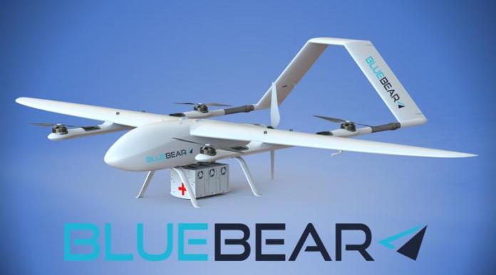
Blue Bear Systems announces the successful completion and flight demonstration of its Air Druids medical delivery programme. This exciting programme has been enabled by funding through the governments Future Flight programme.
We were lucky enough to be joined for our demonstration by Dave Hodgson – Mayor of Bedford, Patrick Lyons – Acting Manager for Economic Growth & Development and Vicki Murdie – Innovation Lead (Future Flight Challenge) for UK Research and Innovation.
The Air Druids programme built upon Blue Bears existing proven CenturionTM C2 swarming drone control system, and drone logistics technologies.
The Airdruids programme demonstrated the seamless integration of the medical payload into Blue Bears existing modular open architecture. This provided the ability to have a real time, fully monitored, temperature-controlled payload tightly coupled to the broader command and control system. The payload is monitored for vibration, temperature, and anti tamper/exposure to light.
Linking the payload data directly into the UAS as opposed to having a separate system such as LTE allows for operation where there is no mobile phone coverage with no data black outs. This enables real time tracking for the entire flight path. This is particularly important for disaster relief where phone networks might have gone down, or for simply flying at higher altitudes where there is no mobile coverage.
Blue Bears open architecture, coupled with their SmartConnectTM technology allows for a fully scalable solution for routine and emergency medical logistics. SmartConnectTM technology enables multi domain unmanned systems including UAVs, UGVs and USVs to all work together collaboratively and be simultaneously tasked from a single location/operator.
Blue Bear also recently demonstrated the scalability of this same technology and how it can be utilised on swarms of larger logistics drones carrying up 60kg of payload for the Royal Marines.
The flexible system design allows drones from any manufacture to be utilised, as the technology is agnostic to the airframe. Thus, the swarming control system will be able to run a logistics flight control hub, tasking, scheduling and monitoring large numbers of drones in real time.
Ian Williams-Wynn, MD said, we have been working on the swarming drone control and logistics systems for several years, and it is now flight proven with up to 20 different drones. We are currently working on further medical logistics projects with more to come in the near future. We welcome opportunities for collaboration to accelerate the swarming drone logistics market.
By PRESS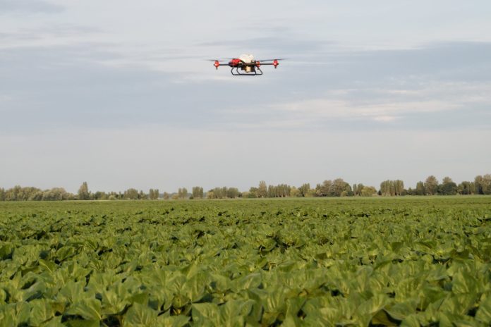
To ensure that sunflower crops will thrive under abnormal weather patterns, fleets of XAG Agricultural Drones have been conducting urgent, timely crop spraying operations in multiple regions of Ukraine. As heavy rains pour in, drone technology can top up the domestic under-equipped agricultural sector facing decline in sunflower crop yield and tight seed availability. This is expected to help safeguard a sufficient global supply of sunflower oil, as well as strengthening Ukraine’s lead as the “breadbasket of Europe”.
Since capturing the Ukraine market at the end of 2020, XAG has rapidly expanded its agricultural drones into varied sustainable farming practices that cover oilseed, corn, wheat, barley, and other grain crops. The spray drones are widely used in cultivated sunflower crops which account for over 20% of Ukraine’s arable land area. Ukraine is known as the world’s largest sunflower oil producer and exporter.
Cultivating Climate-resilience on Farm
During this wet season in July, Ukraine’s sunflower cultivation makes its way into the vegetative stage, with growers on the outlook for foliar diseases such as sunflower rust. Through a nationwide sales and service networks, XAG agricultural drones have been deployed for fungicide applications with high precision, which are urgent and arduous to prevent large-scale yield loss. The autonomous drone operations to spray fungicide was led by ZigZag Solutions and AgroCopter as XAG sub-dealers in Ukraine.
As adverse weather conditions become more frequent due to climate change, significant precipitation could lead to an outbreak of infectious crop diseases caused by fungi, bacteria, and viruses. It also brings out incapability of traditional ground machinery that is difficult to enter the wetland. In the past, agronomists had no other option but to delay operation and later increase pesticide doses as a result of skipping the optimal time to spray.
When classic self-propelled tractors are declined to help, drones can be nimble emergency helpers for Ukrainian farmers. They react much faster and are able to perform spraying right after rains in the inaccessible sunflower wetlands, with less chemical use and zero damage on soils. Having flight speed, height, and droplet size all set up on mobile app, the pilot instructed XAG agricultural drones to spray from 4 metres above the canopy on the pre-programmed path. One drone can cover up to 18 hectares of sunflower farmlands in only one hour.
Sunflower is one of the most important cash crops that offer the best profitability to Ukrainian farmers. It can be used to produce seeds, animal feed and oil with many health benefits as it is low in saturated fat and high in essential fatty acids. However, the 2020/21 sunflower yields in Ukraine decreased by 15% because of a prolonged drought, while the sunflower seed stocks fell to five-year low this February following the second highest levels of crushing activity on record.
Farmers in Ukraine are now turning to drones for closing the yield gap in sunflower harvest while reducing production costs and fossil fuel consumption. “Drones can work on long-stalk crops without damaging them. This creates a huge opportunity for farmers and a high return of investments,” said Valerii Iakovenko, Co-founder of Drone UA who is XAG’s official partner in Ukraine.
“We have totally positive feedback from farmers, during this rainy season drones were the only solutions in many cases. It is a revolutionary new and effective instrument, and more farmers understand that spraying drones are the real tools and XAG is the best of them.”
A Yellow Bumper Harvest Ahead
Ukraine is one of the largest global grain and forage crop producer which plays a major role in feeding the world’s growing population. However, farmers have been incurring relatively rising production costs and higher levels of yield loss, while bearing the brunt of climate impacts. According to World Data Center Ukraine, farm managers estimate that 10 to 20 percent of the standing crops are typically lost due to outdated, inefficient machinery.
As Ukraine is marching its way into a global agricultural powerhouse, the demand for high-tech farming equipment witnesses a continuous high growth now and in the future. Specifically, when farmers have problems entering the field due to crop height and heavy rainfalls, XAG’s AI-controlled agricultural drones can be applied to various stages of sunflower cultivation. This April, after the sunflower seeds were sown until they germinated, drones were sent to remove herbicides on the field to prevent weeds from competing nutrients, water, and sunlight with the seedlings.
At the upcoming flowering and pre-harvest season, XAG drones will fly into the blooming bulk of sunflowers for fungicide spraying and desiccation. The sunflower plant height can reach over 2 meters at this stage, when it was mostly impossible to spray in the past because of the lack of high-clearance machinery.
It is anticipated that Ukrainian farmers can reap an additional up to 10% of harvest using drones that do not cause any damage to crop. Getting the sunflower harvested several weeks early can result in higher yields and lower drying costs. Drones can be the ideal helpers to spray harvest-aid desiccant for speeding up the dry-down process and decreasing crop losses due to inclement weather, lodging, diseases, and bird depredation.
Besides its trademark yellow flower, a bumper sunflower harvest can contribute to brightening the future of global edible oil supply. Drones can be the optimal solution on sustainably boosting sunflower yield and making farming more resilient to climate change.
About XAG
Founded in 2007, XAG is a world-leading robotics and AI company, as well as the world’s largest agricultural drone maker. With the mission of advancing agriculture, it focuses on using technology to empower agriculture and help create a food-secure future. Up to December 2020, XAG’s smart agriculture technologies and solutions have reached 42 countries and regions, serving 9.31 million farmers and 52 million hectares of farmlands.