User blog: Bruce McPherson
- Start of production confirmed for the world’s first electric flying racing car
- 0-62 mph in 2.8s. Thrust-to-weight ratio exceeds F-15 Strike Eagle fighter jet
- First uncrewed races to be announced in the Summer of 2021
“Some of the very first Mercedes, Bentleys and Renaults were racing cars. The pioneers of these marques knew that in order to advance a mobility revolution, they must build their machines for racing. At Airspeeder, we proudly echo that philosophy. To accelerate the arrival of advanced air mobility technology we must leverage sporting competition. The Airspeeder Mk3 is the result of years of engineering, testing and development with the pure purpose of creating the ultimate performance electric flying car.”
Matthew Pearson, Founder, Airspeeder and Alauda Aeronautics
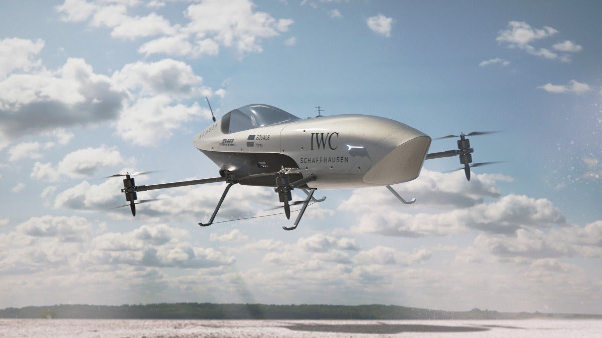
At Goodwood Speed Week, Airspeeder unveiled to the world the Mk3 racing prototype. This remotely-piloted craft showed the form of the world’s first full-scale and functional electric flying racing car. Today, the production version of this revolutionary vehicle is being created at the sport’s technical headquarters in Adelaide, South Australia. Airspeeder is proud to confirm the technical specifications of these craft before they participate in remotely piloted races throughout the second half of 2021.
Airspeeder’s mission is to accelerate a zero-emissions, advanced air-mobility revolution through intense sporting competition. This approach reflects the work of pioneers such as C.S Rolls, W.O Bentley and Karl Benz who built acceptance for what was then a revolutionary new technology, and accelerated their development, by going racing.
Alauda Aeronautics, sister-company to Airspeeder, is currently building ten of these vehicles for races set to take place on three continents in the coming months.
The eVTOL (electric vertical take-off and landing) sector, which is predicted by Morgan Stanley to be worth $1.5 trillion by 2040, is already transforming logistics and even providing medical supplies to remote regions. However, the passenger transport side of the industry has been very much focused on what is termed ‘electric flying taxis’. These promise to transform urban environments and free them from congestion with safe and sustainable transport.
To realise the potential of this technology, a space and place must be created to rapidly accelerate the key elements that will underpin global mass-adoption of advanced air mobility for passenger applications. Racing, as it was for the motorcar and aeroplane, is the answer.
Airspeeder will pioneer a suite of technologies that will refine and demonstrate safety requirements, build acceptance for eVTOL and, as a form of future transport, answer key questions around battery technology, noise and regulation.
The Mk3 remotely-piloted electric flying racing car is at its heart a performance machine. At maximum power it delivers 320kW, equalling an Audi SQ7 performance SUV. The Audi weighs 2,500kg while an Airspeeder racing craft (without pilot) weighs just 130kg. It can lift a weight of more than 80kg, proving the viability of the powertrain for piloted races. Acceleration from 0-62mph takes 2.8 seconds and the Speeder can climb to 500 meters.
A Speeder can turn with extraordinary speed when compared to a traditional fixed wing aircraft or helicopter. The Mk3 vehicle has a thrust-to-weight ratio of 3.5, which exceeds that of an F-15E Strike Eagle (thrust-to-weight ratio of 1.2), one of the most advanced fighter aircraft in the world. The thrust-to-weight ratio, along with other powertrain characteristics, has been verified as part of the exhaustive testing and development programme that preceded the start of full production. Indeed, the rapid hairpin turning potential achieved through an octocopter format has been compared to that of a Formula 1 car, generating up to 5Gs, with the added capability to manoeuvre vertically.
The Airspeeder engineering and technical team is drawn from some of the leading names in performance and racing vehicle engineering including Mclaren, Tom Walkinshaw Racing and Brabham. On the aviation side of the garage, members of the team have led major projects in both civil and military aviation, including Project Lead Brett Hill’s experience as a flight dynamics specialist on the Boeing 747-8 programme.
Together they have developed an advanced carbon fibre structure, carrying strength and weight-saving benefits. Indeed, there is an obsession at Alauda with shedding grams to gain critical seconds in performance. An Airspeeder vehicle consists of a chassis and carbon fibre moulded ‘tub’-style skin. This ensures overall strength to maintain the structural integrity of the vehicle under extreme racing conditions and manoeuvres.
Batteries have been re-designed versus the previous iteration of the Airspeeder to have 90% more capacity with only a 50% increase in weight. The specification of these cells also delivers an exciting strategic layer. Power delivery profiles can be changed by ground-crews to respond to the different requirements of the electronically governed sky-tracks that Airspeeder pilots will follow. For example, a lay-out that demands rapid maneuvers through sharp turns and ascents will require a different power delivery curve from those that demand outright straight-line speed. Ground crews will have to make instant decisions around sacrificing raw power for outright range.
Every Airspeeder includes rapid pit stops. To facilitate this, Alauda’s engineers have developed an innovative ‘slide and lock’ system for the rapid removal and replacement of batteries when on the ground. This technology debuts on the Mk3. Intense internal competition between inhouse pit-crews has driven the pitstop time down to just 14 seconds, which is entirely compatible with any form of ground-based legacy motorsport. This is expected to continue to fall. For context, a Formula 1 pitstop used to take more than a minute.
Airspeeder employs a systems-based approach to safety. This is a recognised methodology from military, civilian and performance aviation. This means that no single operational failure can lead to loss of the primary function of the vehicle, which is controlled flight.
In the early stages of the Mk3’s development simulation, bench testing and integration testing techniques were employed to fully map out these systems. Ahead of live testing, this gave engineers confidence that in the event of a systems failure, vehicles will remain in the air but at reduced performance to ensure the pilot, whether operating remotely in the case of the Mk3, or in the cockpit in future iterations, will be able to safely return to the ground.
During flights, all systems are monitored on the ground through state-of-the-art telemetry. This means that groundcrew are immediately aware of issues and can take appropriate action to bring the craft to ground under control.
Prioritising safety is also inherent to the architecture of the vehicle. The octocopter layout ensures stability in the event of rotor failure or breakage, while the carbon fibre structure of the Speeder has been engineered for overall structural integrity.
The Mk3, which will be operated by an expert remote operator from the ground, features a suite of technologies and engineering elements never before seen on an eVTOL craft. These innovations will be validated in this key uncrewed proving phase and include LiDAR and Radar collision avoidance systems that create a ‘virtual forcefield’ around the craft to ensure close but ultimately safe racing.
THE AIRSPEEDER Mk3 | DRIVEN BY DATA:
Terabytes of data from sensors within every area of the Speeder’s architecture is drawn over any testing or racing cycle. This means on-the-ground pit crews are able to constantly analyse and react to even the smallest variance in performance. From a racing perspective this dictates strategy and pilot approach, and in overall technical terms allows engineers to understand details like aerodynamic performance and even adjust propeller settings in accordance with Speeder behaviour in a multitude of conditions.
Airspeeder works with global cyber protection leader Acronis and their delivery partner Teknov8 to secure this data.
By PRESS
FILE - RCMP use a camera mounted drone as they investigate at the scene of a single vehicle accident along the Queen Elizabeth II Highway, north of Panoka Alta., on Monday Sept. 22, 2014. A plan from the province to use drones to monitor campers has been scrapped after a public outcry. PHOTO BY DAVID BLOOM /David Bloom/Edmonton Sun/QMI Age
The UCP government has grounded a proposal to use aerial drones to monitor campers and outdoor enthusiasts on public lands.
Four days after a request for proposals (RFP) was posted by Alberta Environment and Parks seeking private contractors’ bids to operate a program that would provide surveillance on holidays and long weekends in the summer and fall, Environment Minister Jason Nixon said the plan has been shot down.
“As soon as I became aware of the request for suppliers related to Long Range Remotely Piloted Aircraft Systems (drones) I instructed my department to suspend it,” Nixon said in a statement.
While he said the use of drones for obvious emergency and safety purposes could take place, they’re too intrusive when monitoring camping activities.
“I have been clear with my department that while drones are an effective and cost-effective tool for wildfire monitoring and search-and-rescue assistance, they must never be used to encroach on privacy,” said Nixon.
Later, in an interview, Nixon said he only noticed the RFP on Monday morning, adding the process of drawing them up will be changed.
“Lots of RFPs are going out all the time,” he said.
The now-scrapped RFP had stated the province was seeking “live electro-optical and infrared video to support safety, co-ordination and situational awareness for ground personnel.”
Activities would include detection of campfires and off-highway vehicles operating in restricted areas, along with search-and-rescue assistance and detection of environmental damage, and to detect “gatherings of 10 or more individuals and officer safety support.”
“Operators must possess the ability to provide aerial surveillance both day and night, using heat signature capturing imagery or similar technology,” states the 31-page RFP.
“Operators must have the ability to detect individuals, vehicles and infrastructure such as cabins or fishing huts in remote locations and provide real-time imagery and geographic positional data to an Incident Commander or Operations Officer.”
A public policy think-tank critical of the proposal said it had collected 3,000 signatures within three hours on Monday demanding it be cancelled.
It cited concerns over violation of privacy.
“We have no problems using these to combat wildfires but to spy on Alberta for a weekend of camping is beyond the pale,” said Peter McCaffrey, president of the Alberta Institute.
“My hope would be that this is the work of some rogue bureaucrat and as soon as more senior people become aware of it, it’s canned.”
Nixon said the province already uses drones for search-and-rescue and wildfire suppression purposes, and could use them to supplement helicopters in instances of law enforcement activities.
As spring takes hold and the first long weekend of the summer approaches, there have been a number of citizen reports of off-road vehicles and reckless camping behaviour damaging wilderness areas west of Calgary, such as McLean Creek and Waiparous.
And critics of the UCP government say the $90 annual and $15 daily fee for Kananaskis Country that’ll be required starting June 1 has overlooked areas such as McLean Creek.
The province has beefed up its on-the-ground enforcement with 20 new conservation officers, while all-terrain vehicle fees are on the way along with a random camping levy, said Nixon.
“We take that seriously — it’s primarily a small group of bad actors, and Albertans will see more enforcement on the landscape this season,” he said.
By Bill Kaufmann
|
|

|

Ottawa, ON – The Canadian Owners and Pilots Association (COPA) – the largest aviation association in Canada – introduces new membership options to include the growing drone community.
Drones are profoundly changing the world of aviation, and as this new technology evolves, so too will its role in society. The remotely piloted aircraft are transforming Canadian businesses, enabling new insights and capabilities in disaster management, search and rescue, infrastructure, and countless other industries.
As a trusted leader in advancing and promoting aviation safety, and as a long-recognized voice for General Aviation in Canada, COPA is uniquely positioned to represent both traditional and remote aircraft pilots. A key objective in uniting these communities together is to support COPA’s ongoing efforts for safe integration of all airspace users. Traditional and remote aircraft pilots share common interests in safety and in protecting their freedom to fly.
COPA has been involved with drones and related matters for several years. The association has contributed to the development of popular RPAS tools, including the National Research Council of Canada’s drone site selection tool and has partnered with Canada’s aviation regulator to support education awareness initiatives.
In recognizing the importance of safe integration of remotely piloted aircraft systems (RPAS) into Canadian airspace, COPA is focusing its attention on the following areas: RPAS pilot training and certification; RPAS Traffic Management (RTM); Beyond Visual Line of Sight (BVLOS) Operations; RPAS airworthiness; detect and avoid; search and rescue; and the emergence of the next generation of RPAS.
“As RPAS pilots continue to carve out their place in aviation, COPA will support by providing the resources and community all pilots need to enhance their flying experience,” says Christine Gervais, COPA’s President and CEO. “This is an ideal time to embrace innovation within aviation, especially as many in traditional aviation have been affected by the impacts of COVID-19.”
“Welcoming the drone community will strengthen the aviation sector. And while fear of these new airspace users does exist, there are more benefits to finding common purpose between traditional and remote aviation. These newcomers to our skies are just getting started, and COPA will help unlock the immense potential of this maturing aviation technology.”
COPA RPAS Membership Benefits
COPA RPAS members can look to COPA for regular updates on the regulations or issues that affect their operations, for education and safety programs, insurance coverage, and significant training discounts.
• Through Magnes and Coverdrone, COPA is offering its members an exclusive insurance program, for both recreational and commercial RPAS pilots. This insurance program, available nationwide, includes physical damage coverage, public and products liability; as well as professional and privacy breach liability coverage for commercial drone operations.
• To support pilot development, COPA will be launching an RPAS scholarship. The scholarship targets pilots who have been affected by the COVID-19 pandemic, an initiative to help retain the skills and talents of aviation within the sector.
• Through involvement in industry and government working groups – including Transport Canada’s new Canadian Drone Advisory Committee (CanaDAC), COPA will advocate for enhancements to the current Canadian regulatory framework governing RPAS operations as well as other necessary policy development.
• COPA will be launching several education materials, including guides, webinars and other resources to support pilot development. The organization is hosting RPAS panels, pilot recurrent training and other drone-related workshops at its upcoming Virtual National Fly-In and Aviation Exhibition.
To learn more about COPA’s new membership options, visit
https://www.copanational.org/rpas today.
About COPA
COPA represents over 15,000 pilots and aircraft owners across Canada and is the national voice for General Aviation in Canada. Through the mission of advancing, promoting, and preserving the Canadian freedom to fly, COPA is at the forefront on issues that affect pilots, aircraft and airports; and is an active partner with all levels of government in ensuring a bright future for General Aviation.
For more information on COPA, visit copanational.org
By PRESS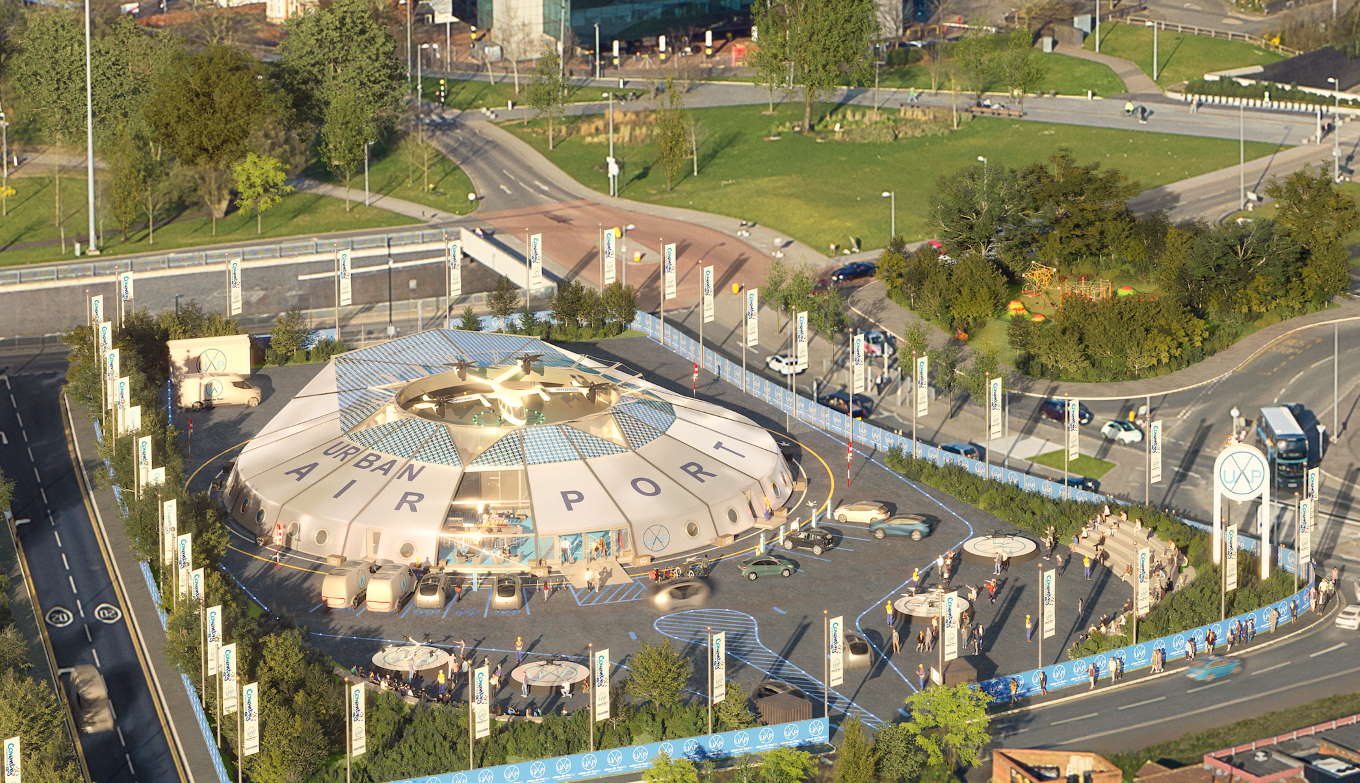
· Coalition of industry and government, led by Urban-Air Port®, to create safe, clean and connected air corridors and ground infrastructure for future flying taxis and drones.
· UK pioneers, Urban-Air Port®, Altitude Angel and Safeguard Vertiports, to deliver the technologies to build the future Air Architecture™ across the UK.
· UK Government championing the Urban-Air Port® programme to strengthen UK leadership in the growing urban air mobility sector.
· Urban-Air Port® and the Air Architecture™ will employ and support sustainable green technology in the fight against climate change.
· First of more than 200 Urban-Air Port® hubs worldwide launching in Coventry in 2021 will demonstrate operational air corridors and ground infrastructure.
· Urban-Air Port® will connect urban centres and under-served communities across the world – from vast modern cities to small towns and even off-grid villages.
· Urban-Air Port® will provide multi-modal transport hubs of the future using net zero emissions and connecting air, road and rail to help unify transport networks, cut congestion and pollution.
Industry leaders Urban-Air Port® have announced a partnership with Altitude Angel and Safeguard Vertiports to design safe, clean and connected Air Architecture™ for future electric air taxis and autonomous logistics drones.
These ‘air roads’ will enable people and cargo to travel by manned and unmanned electric vertical take-off and landing (eVTOL) aircraft. This world-first infrastructure programme, being demonstrated in Coventry later this year, is supported by the UK government as a significant step towards unlocking a future of clean urban air mobility for the UK and will provide a model for other countries to follow.
The Rt Hon Kwasi Kwarteng, Secretary of State for the Department of Business, Energy and Industrial Strategy, said: “Cleaner, inter-city flight technology is vital not only to reducing emissions, but to better connecting remote communities, from small towns in the UK to isolated settlements all around the world. As we build back greener from the pandemic, initiatives like the government-backed Air-One® project will help us develop the infrastructure needed to make our dreams of flying taxis a reality.”
The Government is supporting the development of urban air mobility to provide improved zero-carbon transport connectivity across the UK and reap the benefits from exporting these technologies to support this rapidly advancing global sector.
The global VTOL and drone market is estimated to be up to $2.9trn (£2.17trn) by 2040, according to Morgan Stanley.[i] In the US, NASA predicts urban air mobility could be worth up to $500bn (£375bn) in the near-term.[ii] eVTOLs and drones could enable doctors or medicine to get to patients in record time, urgent deliveries to arrive quickly without causing congestion or pollution and travellers and packages to reach remote communities that don’t have reliable road or rail.
However, NASA estimates that more than 70% of the potential urban air mobility market value is dependent on infrastructure[iii] – this value is what Urban-Air Port® is working to unlock. The company develops scalable, zero emission infrastructure for high frequency air mobility. Its Air-One® project is a world-first hub for future air taxis, drones and ground-based electric transport, such as cars, e-bikes and e-scooters, which will open in central Coventry later this year.
The urban air mobility market is growing fast. The first eVTOLs are expected to be commercialised in the next three to five years.[iv] Hyundai, a key partner of Urban-Air Port®, is one of several companies developing an eVTOL passenger vehicle. Hyundai’s will be commercialised by 2028.[v] Joby Aviation, the US-based aerospace start-up, plans to launch a commercial air taxi service in 2024.[vi] In April, UPS, the global logistics giant, announced a deal to purchase 150 eVTOL vehicles, for delivery in 2024, to cut delivery times and access smaller markets, demonstrating the growing maturity of the sector.[vii]
The challenge now is to design the Air Architecture™ that allows these passenger vehicles to fly within and between cities and towns and to manage the thousands of delivery drones anticipated in the future, with Amazon already planning to launch a UK drone delivery service.[viii]
Ricky Sandhu, Founder of Urban-Air Port®, said: “Our global transport systems are broken. Inner-city transport is congested, inefficient and polluted. In remote locations, it is either non-existent or over-priced, leaving many isolated and increasing economic disparity. But to fix this, we still look to siloed and ancient road and rail infrastructure.
“New innovations mean we can now reimagine transport to perfectly meet the needs of people and provide a cohesive, sustainable and reliable experience. Our Air Architecture™ can unlock clean and beautiful cities and connect the world in new ways – in the air and on the ground – bringing economic prosperity, cutting emissions and improving quality of life. This is a real British innovation success story – the UK can lead the world in accelerating this transport revolution.”
To create ‘air roads’ in which drones and eVTOLs will fly, Urban-Air Port® has formed a memorandum of understanding with fellow British innovators Altitude Angel and Safeguard Vertiports. Altitude Angel has developed an intuitive, cost-effective platform to digitally support the local Urban-Air Port® air traffic zone, enabling it to enhance and provide unified traffic management (UTM) Services. Safeguard Vertiports will develop a certification programme that will meet Civil Aviation Authority (CAA) regulations for safe operational turnarounds. The partners will work together to design, develop and demonstrate operational Air Architecture™ at the Urban-Air Port® Air-One® site later this year.
Altitude Angel provides the world’s leading UTM platform which enables unmanned aerial vehicles (UAVs) and manned eVTOL aviation, to fly between locations safely and securely. Urban-Air Port® is developing a MOU with the CAA and offering support alongside Safeguard Vertiports, a CAA registered member, to define and develop the certification process for future UTM Air Architecture™ and Urban-Air Port® operational requirements.
Richard Ellis, Chief Business Officer at Altitude Angel, said: “We are proud to be part of Air Architecture™. By enabling eVTOL operators to safely transit through ‘air roads’ and integrate their operations into and around these urban airports, we will unlock the future potential of the national airspace infrastructure. Our platform will allow all users of the sky, from air-taxis and drone operators to general aviation and emergency service helicopters to share the airspace safely and securely.”
Chris Wood, Operations Manager at Safeguard Vertiports, said: “We are proud to be part of this developing transport infrastructure, providing critical analysis and support for the development of certifications and standards that will ensure the safe design and use of the platforms in Air Architecture™.”
Air roads: a new Air Architecture™
Similar to existing air corridors for commercial aircraft, air roads will be approved and regulated routes for future eVTOLs that will enable safe and efficient travel between Urban-Air Port® hubs and other sites. In the initial phase, each corridor will provide segregated airspace at defined altitudes for individual manned and unmanned eVTOLs. Similar to traditional air traffic control, the process will initially be managed by people. As the systems mature, traffic monitoring will be conducted by intelligent autonomous systems and supervised by people.
The air roads will initially be separate from existing aircraft corridors, operating at a much lower altitude when unmanned. They will be created between strategic locations, away from buildings and roads. Once the safety and environmental benefits are demonstrated, the airspace will become increasingly unified and will gradually expand to more locations to meet rising demand.
Altitude Angel’s award-winning UTM platform enables manned and unmanned aircraft to be tracked, monitored, communicated with and controlled in unsegregated airspace in real-time. The company has already launched the world’s first commercial drone ‘test corridor’ in open and unrestricted airspace in the Thames Valley, west of London.
Case study: Delivering vaccines in record time
Urban-Air Port® has also partnered with SkyFarer, the drone logistics operations and software company, and Coventry University, to demonstrate medical drone deliveries on the Air Architecture™. The project will take place at the Air-One® site in Coventry later this year. The project partners will demonstrate the technologies that could fly vaccines or medicines to healthcare professionals and patients in record time.
Elliot Parnham, Founder and CEO at SkyFarer, said: “Healthcare is a sector where drones can make a significant impact. Medical drones are an environmentally-friendly, fast and intelligent way of getting the necessary supplies to those that need it most. Building the necessary Air Architecture™ is a significant step towards cutting wait times and improving access to vital vaccines and medicines.”
Urban-Air Port®: the transport hubs of the future
Urban-Air Port® will provide the transport hubs of the future, connecting air, road and rail to improve connectivity, reduce congestion, cut pollution and help achieve zero carbon. The company recently partnered with a global EV charging leader to provide chargers at Air-One® powered by clean hydrogen fuel cells.
eVTOL air taxis and logistics drones have highly accurate vertical take-off and landing capabilities so do not need any runways or large landing areas, allowing Urban-Air Port® sites to be positioned in the areas of greatest demand and close to connecting infrastructure such as rail hubs. eVTOL aircraft are also up to 100 times quieter than conventional aircraft.[ix]
The Urban Air Mobility Division of Hyundai Motor Group has chosen Urban-Air Port® as its priority infrastructure partner to support the global growth of this new sector. In January 2021, Urban-Air Port® was selected as a winner of the UK government’s Future Flight Challenge to develop aviation infrastructure, systems and architecture that enable the next generation of electric and autonomous air vehicles.
Urban-Air Port® plans to develop more than 200 sites around the world in the next five years to meet global demand. Having secured funding for Air-One®, Urban-Air Port® is now in advanced discussions with investors to support its rapid commercialisation and global growth.
About Urban-Air Port® Limited
Urban-Air Port® designs, develops and operates urban-air ground infrastructure through a subscription based service to enable urban air mobility. It is scalable, innovative zero emission infrastructure for future air mobility – such as cargo drones and air taxis but that also supports ground e-mobility systems including EVs, bikes, scooters and cargo vehicles.
The company will be represented by the UK Government Department for International Trade at the UN Climate Change Conference (COP26) in Glasgow later this year.
The Founder of Urban-Air Port®, Ricky Sandhu, will be speaking alongside Kwasi Kwarteng, the UK Secretary of State for Business, Energy and Industrial Strategy, at the Invest Midlands conference on 26 May 2021.
For more information, see: https://www.urbanairport.co.uk/.
About Altitude Angel
Altitude Angel is an award-winning provider of UTM (Unified Traffic Management) software, enabling those planning to operate, or develop UTM/U-Space solutions, to quickly integrate robust data and services with minimum effort. A growing portfolio of enhanced capabilities help our customers to comply with current and future regulations and interface with changing national systems with only minimal effort.
Altitude Angel’s first party solutions also power some of the world’s leading ANSPs, aviation authorities and Enterprises, including LVNL (Netherlands) and Avinor (Norway), empowering them with new capabilities to safely manage and integrate drone traffic into national operations.
Altitude Angel is headquartered in Reading, UK. Altitude Angel’s developer platform is open and available to all at: https://developers.altitudeangel.com/.
About Safeguard Vertiports
Safeguard Vertiports is a subsidiary of Safeguard Engineering Ltd (SEL). SEL is a leading safety management consultancy which incorporates Safeguard Helideck Certification, a fully accredited Aviation Inspection Body (AIB).
Safeguard Vertiports provide specialist advice and support on the design, development and use of vertiport platform areas. This specialist team is working with the regulators to develop an assessment and certification process that can be applied to all future vertiports worldwide, ensuring that each platform area is designed, built and managed to the safest possible standards.
For more information visit: https://www.safeguardvertiports.co.uk
By PRESS
The Massachusetts senator representing Cape Cod will undoubtedly hear from his well-heeled constituents over his proposed bill to charge a $1,000 fee for every landing of private, corporate and charter aircraft in the state. Julian Cyr, one of 37 (of 40) Democrats in the state Senate, has filed a petition to have the body adopt “an Act to mitigate the climate impact of private and corporate air travel.” And although the bill might get an especially prickly reception in the toney seaside Shangri La that he represents, it would similarly apply to virtually every aircraft that doesn’t fly for hire that uses a publicly operated runway anywhere in the state. It actually specifically exempts “public aircraft, scheduled commercial passenger air transportation, freight or cargo aircraft.”
If adopted (the State House is also overwhelmingly Democrat) the new law would order every “airport commission governing a municipal or county owned airport or the board of directors of the Massachusetts port authority shall assess a climate impact landing fee of not less than one thousand dollars on personal aircraft, corporate owned aircraft and charter rental aircraft each time that any such an aircraft is to land at an airport in the commonwealth.” The airports and the state would split the money. The petition was filed in February but came to light last week.
By Russ Niles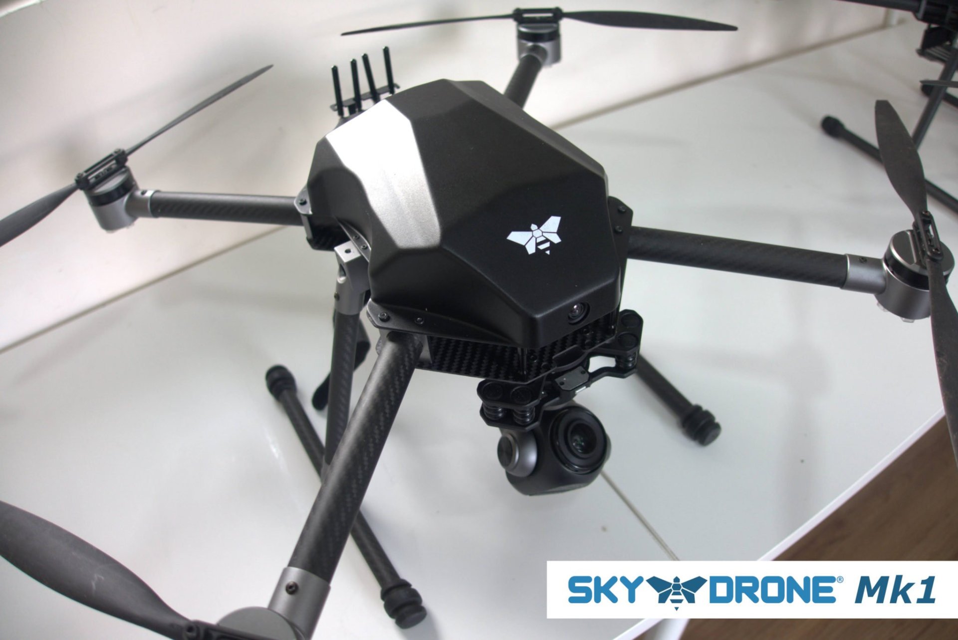
Sky Drone Mk1 is the world’s 1st RTF drone that is exclusively connected by a 5G mobile network connection and it can be pre-ordered now.
HONG KONG, 7th MAY 2021 – Sky Drone announces their latest connected drone product, the Sky Drone Mk1. It is a ready-to-fly drone that is exclusively connected through the 5G cellphone network and has therefore an unlimited control range.
“Sky Drone Mk1 is a major milestone in the evolution of autonomously flying drones. It is now possible to order a ready-to-fly drone from us; off-the-shelf; which can be controlled from anywhere in the world,” said Boris Boege, CEO of Sky Drone.
Sky Drone specializes in drone connectivity technology and has been the leader of 4G/LTE connection devices for drones for the past few years. Now this has progressed to 5G connection devices. Its recent partnership with Germany’s Droniq (joint venture of German Air Traffic control and Deutsche Telekom) is proof of the importance of connected drones in the public airspace –especially when they are flying beyond visual line of sight (BVLOS). Upgrading that connectivity technology to 5G brings new possibilities to the world of connected drones.
Sky Drone Mk1 has an endurance of 45 minutes. With a maximum takeoff weight (MTOM) of 3.4kg, it classifies as UAV Class 2 according to the latest EU Drone regulation. Sky Drone Mk1 is being controlled from a PC or tablet-based ground station with an optional Joystick/Gamepad controller.
To get connected the drone requires a data-enabled SIM-card. Sky Drone Mk1 has global mobile network compatibility, which includes major carriers in all countries across the globe. The drone has already been dispatched to international pre-order customers for industrial, commercial and governmental use.
Sky Drone Mk1 ships worldwide and can be ordered through the Sky Drone website at www.skydrone.aero
By PRESS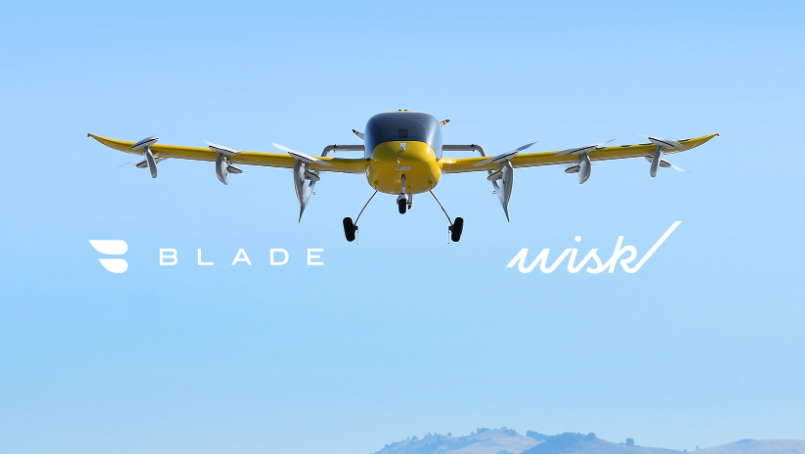
- Wisk, a joint venture between Boeing and Kitty Hawk, to own, operate and maintain up to 30 Electric Vertical Aircraft to be deployed on Blade’s U.S. network
- Blade and Wisk to form a working group to engage with regulators and municipalities and pursue charging infrastructure and next generation air traffic control systems
May 5, 2021—NEW YORK, NY AND MOUNTAIN VIEW, CA—Blade Urban Air Mobility, Inc. and Wisk Aero LLC today announced an arrangement for Wisk to provide Blade with up to 30 Electric Vertical Aircraft (“EVA” or “eVTOL”).
Wisk is an Urban Air Mobility (“UAM”) company dedicated to delivering safe, everyday flight for everyone and is the company behind the first all-electric, autonomous eVTOL aircraft in the U.S. Following FAA certification, Blade and Wisk intend to deploy the aircraft on short-distance routes between Blade’s network of dedicated terminals throughout the U.S., with Wisk aircraft being chartered by Blade at an hourly rate on those routes. Wisk will be compensated based on Blade flight time utilized on the aircraft, which will be owned, operated, and maintained by Wisk for Blade’s use. Blade expects to leverage its existing flight volumes to provide minimum flight hour guarantees to Wisk. Wisk’s deployment of its aircraft on Blade routes is subject to the parties entering into definitive agreements.
Blade and Wisk will also form a working group to assist in the deployment of technologies necessary for aircraft charging and next-generation air traffic management. The working group will also leverage Blade’s six years of experience with UAM services in the most congested markets to inform future Wisk design principles. Wisk currently operates autonomous eVTOL aircraft pursuant to experimental type certificates and plans to begin initial test flights in Blade’s key service areas when possible.
“We look forward to working with Wisk to help accelerate Blade’s transition from conventional rotorcraft to safe, quiet, emission-free Electric Vertical Aircraft,” said Rob Wiesenthal, CEO of Blade.
“This arrangement validates that UAM is the future of mobility,” said Gary Gysin, CEO of Wisk. “To date, we have been focused on developing an aircraft and customer experience that is efficient, accessible, and — most importantly — safe. The combination of our expertise as an autonomous eVTOL aircraft manufacturer and operator, with the operational expertise of Blade, will help usher in an even greater level of safety and service.”
“The Wisk-Blade arrangement is a perfect fit for our asset light model,” said Will Heyburn, CFO and Head of Corporate Development for Blade. “Backed by Boeing’s deep aerospace experience, Wisk will own, operate and maintain their aircraft as part of our network, allowing Blade to focus on delivering a great experience to our fliers.”
Blade and Wisk are both committed to an open-network approach to Urban Air Mobility. Wisk intends to provide aircraft to multiple customer-facing platforms while Blade expects to utilize a variety of EVA, based on mission requirements, and recently announced that it secured 20 piloted EVA from a third-party manufacturer, scheduled for deployment starting in late 2024.
About Blade
Blade is a technology-powered urban air mobility platform committed to reducing travel friction by providing cost-effective air transportation alternatives to some of the most congested ground routes in the U.S. and abroad. Today, the company predominantly uses helicopters and amphibious aircraft. Its asset-light model, coupled with its exclusive passenger terminal infrastructure, is designed to facilitate a seamless transition to Electric Vertical Aircraft (“EVA” or “eVTOL”), enabling lower cost air mobility to the public that is both quiet and zero emissions.
On December 15, 2020, Blade announced it would become a public company through a merger with a special purpose acquisition company, Experience Investment Corp. (NASDAQ: EXPC). Closing of the merger is subject to approval by the stockholders of both Blade and Experience Investment Corp. and the satisfaction or waiver of certain other conditions.
For more information, visit blade.com/investors.
About Wisk
Wisk is an urban air mobility company dedicated to delivering safe, everyday flight for everyone. Wisk’s self-flying, eVTOL (electric vertical takeoff and landing) air taxi, will make it possible for passengers to skip the traffic and get to their destination faster. Based in the San Francisco Bay Area and New Zealand, Wisk is an independent company backed by The Boeing Company and Kitty Hawk Corporation. With a decade of experience and approximately 1500 test flights, Wisk is shaping the future of daily commutes and urban travel, safely and sustainably.
By PRESS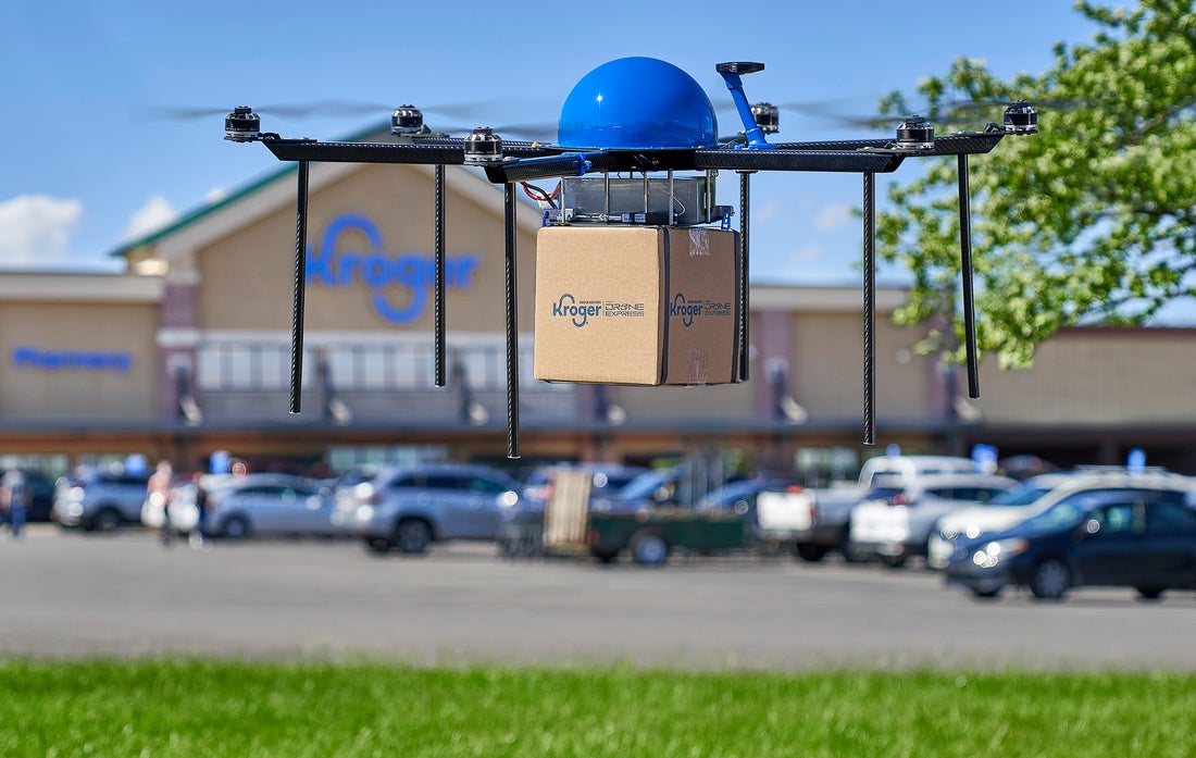
The Kroger Co. (NYSE: KR) and Drone Express, a division of TELEGRID Technologies, Inc., today announced a pilot to offer grocery delivery via autonomous drones, expanding the retailer’s seamless ecosystem and providing customers with anything, anytime, anywhere.
“Kroger’s new drone delivery pilot is part of the evolution of our rapidly growing and innovative e-commerce business – which includes pickup, delivery, and ship and reached more than $10 billion in sales in 2020,” said Kroger’s Jody Kalmbach, group vice president of product experience. “The pilot reinforces the importance of flexibility and immediacy to customers, powered by modern, cost-effective, and efficient last-mile solutions. We’re excited to test drone delivery and gain insights that will inform expansion plans as well as future customer solutions.”
How the Drone Grocery Delivery Pilot Works
The pilot will offer customers unparalleled flexibility as Drone Express technology allows package delivery to the location of a customer’s smartphone not only to a street address, simply meaning a customer will be able to order delivery of picnic supplies to a park, sunscreen to the beach, or condiments to a backyard cookout, for instance.
Kroger is designing bundled product offerings ideal for meeting customer needs within the current weight limits for drone delivery, which is about five pounds. As an illustration, Kroger will offer a baby care bundle with wipes and formula, a child wellness bundle with over-the-counter medications and fluids, and a S’mores bundle with graham crackers, marshmallows, and chocolate. Using Kroger.com/DroneDelivery, customers can place orders and have eligible orders delivered within as little as 15 minutes.
“Autonomous drones have unlimited potential to improve everyday life, and our technology opens the way to safe, secure, environmentally friendly deliveries for Kroger customers,” said Beth Flippo, Chief Technology Officer, TELEGRID. “The possibilities for customers are endless – we can enable Kroger customers to send chicken soup to a sick friend or get fast delivery of olive oil if they run out while cooking dinner.”
Drone Express will commence test flights this week near the Kroger Marketplace in Centerville, Ohio (1095 South Main Street). The flights will be managed by licensed Drone Express pilots from an on-site trailer with additional off-site monitoring. Customer deliveries are scheduled to begin later this spring, and a second pilot is scheduled to launch this summer at a Ralphs store in California.
“The launch of the pilot in Centerville is the culmination of months of meticulous research and development by Kroger and Drone Express to better serve and meet the needs of our customers,” said Ethan Grob, Kroger’s director of last mile strategy and product. “We look forward to progressing from test flights to customer deliveries this spring, introducing one more way for our customers to experience Kroger.”
“Kroger and Drone Express made a great choice in piloting this program in Centerville – a community with a robust business network focused on progress and stability near the birthplace of aviation,” said Centerville Mayor Brooks Compton. “Families here have the power to transform grocery delivery around the nation and the globe. We look forward to placing our first order.”
By PRESS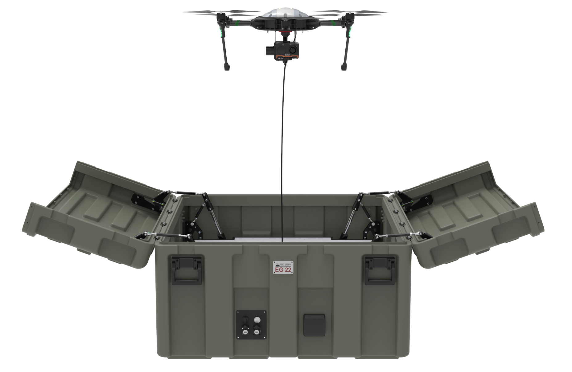
Easy Aerial, a leading provider of autonomous drone-in-a-box based inspection, monitoring, and surveillance solutions, announced today that its Easy Guard ground station has received its certification of Military Standard Specification MIL-STD 810G. Easy Guard is a smart, independent aircraft hangar for takeoff, landing and charging. It features an automated roof opening and closing system and is made from military-grade materials, rendering it mobile, rugged and weather resilient. Easy Guard’s size and weight allow it to be rapidly mobilized and deployed from stationary and mobile launch sites, such as a standard pickup truck or other vehicle configuration, traveling up to 25 miles per hour. The ground station comes equipped with numerous sensors and four external cameras for situational awareness of the deployment site.
Established by the United States Air Force after World War II, MIL-STD-810 certification provides a formal methodology for testing equipment under simulated environmental conditions to ensure that all equipment used by the military can fully operate in a variety of harsh conditions including extreme temperatures, pressures, shocks, and radiation. MIL-STD-810 Revision G is the latest and most rigorous evolution of the standard to date.
To achieve its certification, an Easy Guard was subjected to a range of independent field tests running from October 2020 through January 2021. Conducted by E-Labs Inc., a full-service climate testing laboratory specializing in aerospace and military equipment, the simulations tested the Easy Guard’s ability to withstand radiation (1,100 W/m2), long-term sun exposure (temperatures of over 130F), humidity (50% RH), and hurricane and sandstorm force winds (40 MPH). Multiple test cycles were conducted in both operating and storage/ transportation, non-operating conditions. Not only did Easy Guard pass all these tests, it did so with zero abnormal findings – surpassing all expectations.
“In an era where safety and reliability are non-negotiable, we take great pride in the fact that not only do we offer state-of-the-art security technologies but that this technology is backed by hardware with a proven track record for withstanding even the harshest environments,” said Easy Aerial CTO Ivan Stamatovski.
Easy Aerial has experienced a dramatic increase in demand for its expanding line of ISO9001-certified free-flight, tethered, and hybrid drone systems. The company expects this trend to continue with the addition of Easy Guard MIL-STD-810G certification.
“With this superb achievement, Easy Aerial continues to revolutionize and set the standard for the drone-in-a-box industry by delivering robust and reliable products that fulfill an increasing demand for high endurance autonomous, drone-based, monitoring and surveillance systems for military and commercial customers around the world,” said Ido Gur, CEO of Easy Aerial.
About Easy Aerial
Easy Aerial is a leading provider of autonomous drone-based monitoring solutions for commercial, government, and military applications. Developed, patented and manufactured in the United States, Easy Aerial’s unique free-flight, tethered and hybrid drone-in-a-box systems are fully autonomous, modular, portable, and rugged, with the ability to operate in the most adverse weather conditions. They can be deployed anywhere for many mission-critical applications such as perimeter and border security, event monitoring, first responder support, agriculture monitoring, and industrial inspection without the need for a human operator. The company’s customer base includes military, government, aerospace, transportation and commercial organizations, with systems operating worldwide. Easy Aerial was founded in 2015 and headquartered in Brooklyn, New York, with regional offices in Tel-Aviv, Israel, and Belgrade, Serbia. Learn more at www.easyaerial.com
By PRESS