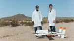
User blog: Bruce McPherson
Benedict Mason
We are committed to enabling drone technology and demonstrating its potential, whilst supporting a sustainable future where drones change the way we view, interact with, and move around our world.
There is an ever-increasing need for a real-time drone transponder and e-Identification to increase airspace safety, to enable a future where drones can share the skies with manned aviation, and with each other.
Recognising this need, governments and aviation authorities around the world have recommended that all drones, including existing ones, should be electronically conspicuous by law.
We have today released AeroPing, a small and lightweight electronic device that easily attaches to existing drones. It provides e-Identification and location, with a very high degree accuracy, in real time.
When drone pilots use AeroPing, authorities and air traffic managers can visualise and track drone flights alongside manned aircraft on our AeroTracker interface, which is available on a wide range of devices and is set to be released shortly.
On this interface, airspace managers and drone users can set customised geographical warning zones. When an aircraft is detected inside a designated area, real-time alerts and notifications are displayed on the interface and can be sent to a device of the user’s choice – including mobile phones and smart watches.
Full and comprehensive flight logs are also stored on the AeroTracker interface, which can replay previous flights in full.
Combined with the AeroTracker interface, AeroPing provides a complete solution for authorities and air traffic managers to identify and track drones alongside other forms of aviation in their area of responsibility, whilst providing reassurance, real-time information, and flight logs for drone operators.
AeroPing has many real world uses for drone operator too, including:
• Increasing airspace safety by improving awareness
• Automatic flight log recording for pilots.
• Increasing accountability.
• Unlocking restricted airspace.
• Enabling operations alongside manned aviation.
• Supporting insurance claims with an independent source of data.
• Aiding in drone fleet management.
• Tracking assets in real-time.
• Acting as a defence if accused of breaking drone regulations.
Richard Gill, our CEO and Founder, said:
“We believe that by tracking all aircraft, we can unlock the skies. AeroPing, alongside the AeroTracker interface, is designed to do just that”.
“It has the potential to be game changing; it will enable drones to be integrated into our skies alongside manned aircraft, with data that can be assessed in real-time by relevant authorities and drone pilots”.
“Our AeroTracker interface makes the process simple, and is available on a variety of platforms, with the ability to send zone alerts sent directly to smart watches or to mobile phones”.
“We are proud that our work here at Drone Defence has the potential to enable the future of drone technology, and believe AeroPing, alongside the AeroTracker platform, will be a true game changer”.
 AeroPing is lightweight, durable, and easy to use
AeroPing devices operate completely independently. They have their own power source and sensors for position, altitude, temperature, pressure, speed and direction. A drone operator simply attaches AeroPing to a drone, and it is ready for use – it’s that simple.
For more information, contact us.
By PRESS
PHOENIX, April, 2021 – Honeywell (NYSE: HON) has successfully demonstrated multiple alternative navigation technologies for military aircraft. These new products are intended to help ensure seamless navigation, even when GPS signals are blocked, interrupted or unavailable.
Since GPS technology was developed decades ago, it has become commonplace in everything from cars to mobile phones to aircraft. Though GPS is widely used, access to GPS signals isn’t always guaranteed, even with the most modern systems. In the case of military operations, GPS-jamming, whether intentional or not, can block vital signals from conveying critical information regarding positioning, navigation and timing. In these instances, it’s important for military vehicles and aircraft to be equipped with alternative navigation technologies, like celestial or vision navigation, to maintain operational readiness.
“Most of us have experienced some level of GPS unavailability, perhaps on our mobile phones or car navigation systems. It’s a minor inconvenience for us, but for military operations, not having access to critical positioning and timing information can make or break a mission,” said Matt Picchetti, vice president and general manager, Navigation & Sensors, Honeywell Aerospace. “We’re very excited to roll out this robust lineup of alternative navigation solutions, which are specifically designed to address the needs of our military customers and give them the added layers of redundancy needed to successfully carry out their operations, even if they lose access to GPS signals.”
Alternative navigation technologies provide a different means of measuring position, velocity and heading when GPS is disrupted. These technologies include the following:
- Vision-Aided Navigation: This technology uses a live optical or infra-red camera feed and compares it with maps to provide a passive, not jammable, highly accurate alternative position, navigation and timing solution that provides GPS-like accuracy in GPS-denied or jammed conditions.
- Celestial-Aided Navigation: Honeywell’s celestial-aided navigation technology observes stars and “reference objects” orbiting the earth such as satellites, which have known positions and velocities. This technology compares those reference objects to stars and can determine position and velocity, the same way a GPS could.
- Magnetic Anomaly-Aided Navigation: Navigation technology that measures magnetic strength using sensors and compares this data with known geographical magnetic maps to accurately identify the position of the aircraft relative to the Earth.
Alternative navigation prototype systems will be available in 2022 with initial deliveries expected to start in 2023.
Honeywell navigation systems are used by nearly every aircraft flying today to guide millions of passengers to their destinations. Since 1914 when the first autopilot used Honeywell gyroscopes to hold the plane stable during flight, Honeywell has delivered more than 500,000 high-performance inertial sensors across several platforms on land, in the air and at sea.
For more information on Honeywell’s alternative navigation solutions, visit the product page.
About Honeywell
Honeywell Aerospace products and services are found on virtually every commercial, defense and space aircraft. The Aerospace business unit builds aircraft engines, cockpit and cabin electronics, wireless connectivity systems, mechanical components and more. Its hardware and software solutions create more fuel-efficient aircraft, more direct and on-time flights and safer skies and airports. For more information, visit www.honeywell.com or follow us at @Honeywell_Aero.
Honeywell is a Fortune 100 technology company that delivers industry-specific solutions that include aerospace products and services; control technologies for buildings and industry; and performance materials globally. Our technologies help aircraft, buildings, manufacturing plants, supply chains, and workers become more connected to make our world smarter, safer, and more sustainable. For more news and information on Honeywell, please visit www.honeywell.com/newsroom.
By PRESS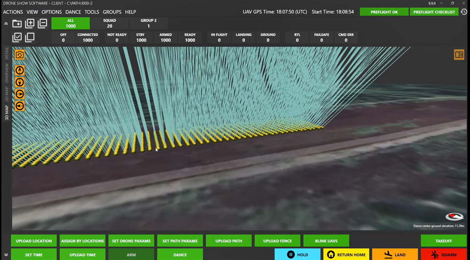
Riga, Latvia; Seattle, Washington USA – SPH Engineering, a multiproduct drone software company, has released a Drone Show Software update which allows users to run a drone swarm show with up to 1,000 UVify IFO light show drones.
The technology was upgraded in partnership with UVify and is only available with UVify IFO swarm light show drones.
The software was developed from managing from 500 to 1,000 UVify IFO swarm light show drones, with performance being upgraded to improve the ability to control large scale fleets. While scaling a fleet, the software allows preflight checks to guarantee safety during the show based on a dual geofence principle.
“2020 was a turning point in outdoor entertainment history as drone light shows were almost the only activity that could be safely enjoyed by the public from a distance. Options varied from small 20-50 drone shows performed by SMEs, 100-500 drone shows used mainly for marketing in the sky, and large-scale shows of thousands of drones organised by governments around the world to thank pandemic frontliners.
The Drone Show Software team has been developing technology to meet growing
customer demands, and is now proud to offer a solution that makes it possible to light the sky with up to 1,000 drones,” Alexey Dobrovolskiy, CTO at SPH Engineering, says.
“Humanity has always looked towards used the wide-open sky to deliver and receive messages. With the help of 21st-century satellite and drone technology drone light shows are introduced and the idea that we can utilize unused space in the sky for something more has become a vivid reality. UVify’s IFO drone technology in conjunction with SPH Engineering’s DSS, is transforming the way in which we
connect and communicate with one another,” Hyon Lim, CEO at UVify, comments.
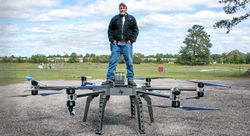
The SCORPION XL UAS is the first of its type super heavy lift drone. With its large frame, the UAS is capable of transporting a broad variety of payloads weighing up to 1000 pounds. Both top and bottom mounting options allow for unparalleled versatility.
The existing prototype is an impressive size, 18 feet from prop tip to prop tip.
Six booms hold twelve motors creating 2,694 pounds of thrust.
*MSRP $1.7M
- Maximum cargo weight: 1,000 lbs (454 kg)
- Empty weight: 180 lbs (82 kg)
- Flight time: Up to 6 hours (using fuel cells for the power source)
- Maximum speed: 43 knots (49 mph, 80 km/h)
- Maximum altitude: 1,000 feet MSL
- Propellers: 12
- Electric Motors: 12
- Power source: Electric batteries or fuel cells
- Airframe material: 7075 aircraft aluminum, outer skin is carbon fiber/Kevlar hybrid panels
- Propeller booms: Titanium tubing
- Landing gear: 4 landing legs (cargo attaches to the bottom of the landing legs)
- Airframe size: 28 inches H X 44 inches W X 72 inches L (711 mm H X 1,118 mm W X 1828 mm L)
- Safety Features: Distributed Electric Propulsion (DEP), provides safety through redundancy for its passengers and/or cargo. DEP means having multiple propellers and motors on the aircraft so if one or more motors or propellers fail, the other working motors and propellers can safely land the aircraft. If one or more motors fail, the drone will go into recovery mode. If all motors shut down, a parachute will land the drone to safety.
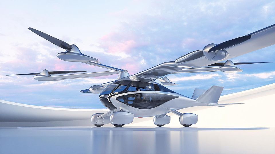
NFT Inc, today announced it is now taking pre-orders for the ASKA™, the first electric vertical take-off and landing (eVTOL) vehicle designed for consumers.
The company has also opened the world’s first consumer flying car showroom. Located in Los Altos, the heart of Silicon Valley, the sales showroom features demonstration models of the ASKA™ and also functions as a learning center about urban air mobility.
ASKA™ is a new door-to-door mobility option offering the freedom to choose to travel on the road or in the air. The four-seater ASKA™ drives on the road like a car, capable of vertical takeoff and landing (VTOL), as well as short takeoff and landing (STOL), and flies like an aircraft. This private commuter vehicle enables people to live in a quality environment outside urban areas and to quickly and easily commute to the city center – door to door.
Pre-orders and Pricing
A special limited edition of ASKA™ is now available for preorder and priced at $789,000. Interested buyers can register at ASKA’s website www.askafly.com to start the sales process and to place a $5000.00 deposit to secure their place on the preorder list. The deposit will be held in an escrow account and is fully refundable. Customers placing pre-orders will also be granted 1 option of share equity if eligibility requirements are met to comply with securities laws. VIP services included in pricing are Pilot License training, Customized interior/exterior design, and a Personalized license plate. The ASKA™ is targeted for delivery in 2026, pending standard regulatory approval and certification.
Revolutionary aerodynamic design
ASKA™ represents a new dimension of innovation that delivers optimal structural performance and integrity. The revolutionary aerodynamic design (patent pending) enables ASKA™ to provide an excellent driving experience on the road and fly safely and efficiently in the air. The initial limited model of ASKA™ has a flight range of up to 250 miles powered by electric motors, and is equipped with a range extender as a redundant safety system. Full electric system architecture of ASKA enables future models to convert range extenders to any other energy source such as hydrogen.
People can board ASKA™ at their home, on the street or in a parking lot, and drive it like a regular car. The size of a large SUV in drive mode, the ASKA™ is a performant road vehicle. To easily transition to flight mode, ASKA™ lifts off vertically in a designated vertipad launch space – no need to travel to a special air terminal or wait in line with other travelers. As the wings open, ASKA™ transitions to smooth flight, programmed to the driver’s destination. After safely transitioning to a vertical landing in a vertipad, ASKA™ can be driven as a car, or be parked in a standard parking lot, on the street, or in a garage. Flying the vehicle will be made simple through semi-autonomous technologies, although pilot training will still be needed to operate ASKA in the air.
Designed for the highest level of safety
The FAA and EASA have moved ahead to certify street-legal conventional aircraft. ASKA™’s development and flight testing are being conducted in accordance with FAA and National Highway Traffic Safety Administration (NHTSA) guidelines for certification.
Dual type of power supply sources exist for optimal safety: each rotor has an independent battery power source plus a range extender power to ensure continued flight and a safe landing in the event of an emergency.
ASKA’s full scale flight demonstrations will be taking place in 2022, and the company is part of NASA’s Advanced Air Mobility National Campaign, along with Boeing, Bell, and others; ASKA is the only consumer-oriented company in this group.
“We have focused significantly on ASKA’s safety elements, which include dual energy sources, large wings, large propellers, 6 pack of batteries to ensure ASKA™ is as safe in the air as it is on the ground. We anticipate that flying cars that are accessible to the general public will be as instrumental in re-defining how and where we live, as the original automobile was to the foundation of our country’s highway and road systems.” said Guy Kaplinsky, Co-founder & CEO, NFT, Inc. “To build a better society and a better economy, we need better transportation solutions, and flying cars will be a part of that equation,” said Maki Kaplinsky, Co-founder & Chair/COO, NFT Inc.
To learn more about ASKA™ and for preordering information, please visit www.askafly.com
The site also provides opening hours and directions to visit the ASKA™ showroom.
ABOUT NFT Inc
NFT Inc was founded in 2018 by serial entrepreneurs Guy Kaplinsky and Maki Kaplinsky. Headquartered in Los Altos, CA, the company bridges aviation and automotive and focuses on air mobility transportation solutions. The team includes aerospace engineers, automotive engineers, aerodynamics experts, flight control experts, who share a vision of reshaping the future of transportation with a real, semi-autonomous and autonomous flying car. The ASKA™ drive and fly electric vertical takeoff and landing vehicle (eVTOL) is now available for preordering as a first limited edition. Follow us on Twitter at @ASKAFLY and on Instagram at ASKA.FLY
According to the new market research report “Drone Package Delivery Market by Solution (Platform, Infrastructure, Software, Service), Type (Fixed-Wing, Multirotor, Hybrid) Range (Short <25 km, Long>25 km), Package Size (< 2Kg, 2–5 Kg, > 5Kg), Duration, End Use, Region- Global Forecast to 2030”, published by MarketsandMarkets™, the Drone Package Delivery Market is projected to grow from USD 528 million in 2020 to USD 39,013 million by 2030, at a CAGR of 53.8% from 2020 to 2030. The growth of the market across the globe can be attributed to growing demand for fast delivery, rising amendments in regulatory frameworks to encourage drone package delivery, and increasing demand for lowering carbon emission.
Ask for PDF Brochure: https://www.marketsandmarkets.com/pdfdownloadNew.asp?id=10580366
Based on solution, the service segment is projected to lead the drone package delivery market during the forecast period.
Based on solution, the drone package delivery market has been classified into platform, software, infrastructure, and service. Drones are becoming accessible to smaller logistics operations for running a warehouse and are increasingly adopted in the delivery of food items, product packages, and medical supplies, among others. The growing use of delivery drones leads to the requirement for proper software and infrastructure that support them. Combined with good logistics software, drones can drastically improve the efficiency. Online retail service providers and logistic companies are focusing on developing innovative drones which can carry heavy payload to deliver packages at customer’s doorstep. In the industries such as healthcare, logistics, and food, multirotor drone has the capability to fly autonomously to delivery package at the location provided by customer of the respective company. Thus, the benefits of serial delivery drones in the service industry is driving the demand for drone services in the drone package delivery market.
Based on package size, the <2 kilograms segment is projected to lead the drone package delivery market from 2020 to 2030.
Based on package size, the drone package delivery platform market has been segmented into <2 kilograms, 2–5 kilograms, and >5 kilograms. The <2 kilograms package size segment is anticipated to lead the drone package delivery platform market in 2020, owing to a rise in demand for lightweight retail good packages across the globe.
Based on type, the hybrid segment is projected to grow at the highest CAGR during the forecast period.
Based on type, the drone package delivery platform market has been segmented into fixed-wing, multirotor, and hybrid. The hybrid segment is estimated to register the highest CAGR during the forecast period. Drone manufacturers across the globe are focusing on the development of drones for use in the delivery of packages within the city limits and also on the advancements of the drone technologies. The hybrid type segment is projected to witness the highest CAGR. Features such as vertical landing and AI-based collision avoidance will increase the market for hybrid drones. For instance, in June 2019, Amazon.com, Inc. launched its Prime Air delivery drone, a hybrid drone capable of delivering packages weighing up to 3 kilograms within 30 minutes to customers residing within a 25-kilometer range.
Based on end-use, the medical aids delivery is projected to lead the drone package delivery market from 2020 to 2030.
Based on end-use, the drone package delivery service market has been segmented into food delivery, retail goods delivery, postal delivery, medical aids delivery, precision agriculture delivery, industrial delivery, and weapon & ammunition delivery. The medical aids delivery segment is projected to lead the market during the forecast period. The medical and healthcare sector has adopted drones to carry out effective delivery of medicines and medicinal equipment within and outside the hospital premises. These drones are used for pharmacy and laboratory pickups and deliveries, thereby optimizing labour productivity in hospitals. The coronavirus outbreak has put increased pressure on healthcare services across the world. The virus has caused greater demand for laboratory testing a well as an urgent need for personal protective equipment and devices to enable remote monitoring of patients with milder symptoms. Drone delivery has proved to be a useful solution in the wake of COVID-19 pandemic providing contactless deliveries and driving the market for medical aids delivery segment.
Browse in-depth TOC on “Drone Package Delivery Market“
341 – Tables
54 – Figures
359 – Pages
Inquiry Before Buying: https://www.marketsandmarkets.com/Enquiry_Before_BuyingNew.asp?id=10580366
The North American and Asia Pacific regions are projected to be high growth potential markets for the drone package delivery during the forecast period.
The drone package delivery market in the North American region is expected to witness substantial growth and register the highest CAGR during the forecast period. The region’s growth is attributed to the increasing trend of online shopping on e-commerce platforms and favorable FAA regulations in the US. The rise in investments from key players to support start-up companies for establishing parcel service platforms in the region will contribute towards the growth of region during the forecast period.
The market in Asia Pacific is expected to exhibit highest market share due to the increasing demand for online food purchases among the huge population. The rising trend of online grocery purchases in emerging economies such as India, China, South Korea, and Malaysia among others will drive the regional market growth in the upcoming years. In May 2020, India’s Ministry of Civil Aviation (MoCA) launched a new portal, GARUD, to provide conditional exemptions to drone companies. Such initiatives will open new expansion avenues for drone service providers.
Major players in the drone package delivery market are Amazon.com, Inc. (US), DHL International GmbH (Germany), United Parcel Service of America, Inc. (US), Zipline (US), Matternet Inc., (US), Airbus S.A.S. (Netherlands) FedEx (US), Matternet (US), EHang (China), and Wing Aviation (US), and Boeing (US). These companies have strong distribution networks in the logistics business across North America, Europe, Asia Pacific and other regions in turn driving the demand for last mile deliveries and drone package deliveries.
Related Reports:
Autonomous Last Mile Delivery Market by Platform (Aerial Delivery Drones, Ground Delivery Vehicles (Delivery Bots, Self-driving Vans & Trucks)), Solution, Application, Type, Payload Weight, Range, and Region – Global Forecast to 2030
Drone Logistics and Transportation Market by Solution (Warehousing, Shipping, Infrastructure, Software), Sector (Commercial, Military), Drone (Freight Drones, Passenger Drones, Ambulance Drones), and Region – Global Forecast to 2027

Despite the majority of the aviation industry continuing to feel the impacts of COVID-19, a growing number of drone pilots and operators are taking to the skies in Canada. From June to December 2020, NAV CANADA received nearly 16,000 Remotely Piloted Aircraft System (RPAS) flight authorization requests, a 54 per cent increase over the same period in 2019.
This represents a small fraction of Canada’s drone traffic, as NAV CANADA only reviews requests from drone pilots and operators who wish to fly in airspace where the company provides air traffic services, also known as controlled airspace. These flight authorization requests are reviewed to ensure the safety of every aircraft sharing Canada’s airspace.

Panoramic photo of Calgary, Alberta captured by videographer and drone pilot Eric González in April 2020.
“Many drone pilots and operators work in industries that haven’t slowed down during the pandemic,” says Alan Chapman, Director of RPAS Traffic Management at NAV CANADA. “Everyone from aerial real estate photographers, first responders, journalists, drone hobbyists and professionals in many other industries rely on NAV CANADA to ensure they are able to safely operate their drones away from other aircraft flying in Canada’s skies.”
Chapman also credits drone pilots and operators’ growing awareness of Transport Canada’s RPAS rules and regulations for the increase in RPAS flight authorization requests. Transport Canada’s RPAS regulations came into effect on June 1, 2019 and apply to everyone who pilots and operates drones in Canada.
Cleared for takeoff
Eric González, a Transport Canada certified drone pilot and videographer based in Calgary, Alberta, captured some of his hometown’s stillness towards the beginning of the pandemic with his DJI Mavic 2 Pro drone. In a video he titled Voicemail 2020: A visual love letter to Calgary, González shared footage filmed at some of Cowtown’s most iconic locations.
González says at the beginning of the pandemic, as lockdowns were happening across the country, the places we call home began to look very different. “Our entire way of life changed in a matter of weeks,” González explains, “with all these empty businesses and streets, I came up with the idea for a visual voicemail for all those who stepped away from their daily routine. The video is meant to be a message of hope and reassurance.”
To ensure he was able to capture video footage safely and legally, González obtained permission from private property owners to fly his drone over their land. He then submitted RPAS Flight Authorization Requests to NAV CANADA and discussed the details of his proposed flights with his local NAV CANADA RPAS coordination office.
“The RPAS coordination office helped me time my flights to capture epic sunsets,” adds González. “Without the use of the drone and its ability to get unique angles, the video would not have had the same impact.”
This past summer in Montreal, Quebec, Radio-Canada drone videographer Vianney Leudière captured footage of a humpback whale swimming in the St. Lawrence River in front of Montreal’s Old Port.
A Radio-Canada newsroom editor received a tip that a whale was swimming close to the Old Port and asked Leudière to try to document the unique event. Unfortunately, high winds and rain made him doubtful he would be able to film the whale’s visit, so he checked the weather forecast and decided to return to the river later that evening when the rain and wind was expected to stop.
After dinner with his family, Leudière went to the river with his children and spouse by his side to help him search for the whale. And sure enough, as the rain clouds blew away, the whale emerged from the water to perform for Leudière, his family and a small group of onlookers.
“The whale gave us an amazing show,” says Leudière. “My family stood petrified in admiration, eyes sparkling, as we watched the whale emerge from the water.”
Leudière says he used a micro drone, weighing less than 250 grams, to capture the footage. “The hardest part was trying to figure out where the whale was going to emerge from the water,” adds Leudière. “For a few moments, happiness from this rare sighting eclipsed the weight we were feeling from pandemic.”
CBC/Radio-Canada’s drone team captured some incredible footage of the humpback whale hanging out in the St. Lawrence River in front of Montreal’s Old Port.
As always, the team acquired all necessary permissions to film and followed all safety protocols when operating the drone. pic.twitter.com/wIni6mvGmY
— CBC Montreal (@CBCMontreal) June 2, 2020
In June 2020, researchers at the Ward of the 21st Century, University of Calgary (U of C), Southern Alberta Institute of Technology (SAIT), Alberta Health Services (AHS), Provincial Laboratory for Public Health (ProvLab) and the Stoney Nakoda Nation partnered to assess the effectiveness of delivering personal protective equipment, COVID-19 tests and other medical supplies to remote communities with drones.
“One of our goals with this project is to develop a comprehensive set of standard operating procedures, so this delivery system can be used safely around the world,” says Wade Hawkins, principal investigator at SAIT’s Centre for Innovation and Research in Unmanned Systems. “We hope to create a scalable fleet of drones that includes everything from small remotely piloted aircraft that can carry light payloads a few kilometers to larger fixed wing aircraft that can travel up to 800 kilometers and potentially drop supplies by parachute.”
The pilot project has already caught the attention of the World Health Organization, who is exploring the possibility of using drones to assist with the fight against COVID-19 in remote parts of Africa.
“Some of the communities involved with our study are very secluded and are only accessible by 4×4 vehicles,” adds Hawkins. “In addition to delivering potentially life-saving medical supplies, we hope to change people’s perceptions of being isolated.”
Preparing for growing demand
In anticipation of the continued growth in drone traffic in Canada, in spring 2021, NAV CANADA will release NAV Drone, NAV CANADA’s official drone fight authorization application. Available on desktop and mobile devices, NAV Drone will help equip drone pilots and operators with tools they need to safely operate their drones in Canadian airspace.
Pilots and operators will be able to plan and schedule drone flights, receive authorization responses from NAV CANADA, discover where they can and can’t fly and review important information about Canada’s airspace.
Currently, all drone flight authorization requests for flights in controlled airspace are approved manually by NAV CANADA employees and based on their complexity, can each take upwards of 48 hours to complete. With NAV Drone, NAV CANADA anticipates approximately 70 per cent of the requests will be approved automatically in the app, reducing the wait time for drone pilots and operators, and allowing NAV CANADA employees to focus on the increasing number of requests for access to fly in controlled airspaces that require detailed reviews.
“The drone flight authorization data tells a very fascinating story,” says Chapman. “The drone industry and demands on NAV CANADA’s services are evolving rapidly, so we’re innovating to meet the needs of drone pilots and operators today and well into the future.”
NAV Drone will be available on the Apple and Google Play app stores. A web version will be available on the NAV CANADA website.
Feature image: SAIT’s test flight team executes a successful flight at Stoney Nakoda Nations Morley reserve on June 25, 2020. Photos by Riley Brandt, photographer, University of Calgary.
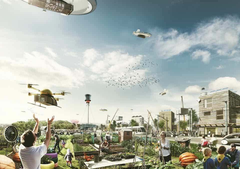
Drones, personal flying vehicles and air taxis may be part of our everyday life in the very near future. Drones and air taxis will create new means of mobility and transport routes. Drones will be used for surveillance, delivery and in the construction sector as it moves towards automation.
The introduction of these aerial craft into cities will require the built environment to change dramatically. Drones and other new aerial vehicles will require landing pads, charging points, and drone ports. They could usher in new styles of building, and lead to more sustainable design.
My research explores the impact of aerial vehicles on urban design, mapping out possible future trajectories.
An aerial age
Already, civilian drones can vary widely in size and complexity. They can carry a range of items from high resolution cameras, delivery mechanisms and thermal image technology to speakers and scanners. In the public sector, drones are used in disaster response and by the fire service to tackle fires which could endanger firefighters.
During the coronavirus pandemic, drones have been used by the police to enforce lockdown. Drones normally used in agriculture have sprayed disinfectant over cities. In the UK, drone delivery trials are taking place to carry medical items to the Isle of Wight.
Alongside drones, our future cities could also be populated by vertical takeoff and landing craft (VTOL), used as private vehicles and air taxis.
 Travelling in vertical takeoff and landing craft (VTOL) could become commonplace in the future. Chesky/Shutterstock
These vehicles are familiar to sci-fi fans – the late Syd Mead’s illustrations of the Spinner VTOL craft in the film Blade Runner captured the popular imagination, and the screens for the Spinners in Blade Runner 2049 created by Territory Studio provided a careful design fiction of the experience of piloting these types of vehicle.
Now, though, these flying vehicles are reality. A number of companies are developing eVTOL with electric multi-rotor jets, and a whole new motorsport is being established around them.
These aircraft have the potential to change our cities. However, they need to be tested extensively in urban airspace. A study conducted by Airbus found that public concerns about VTOL use focused on the safety of those on the ground and noise emissions.
New cities
The widespread adoption of drones and VTOL will lead to new architecture and infrastructure. Existing buildings will require adaptations: landing pads, solar photovoltaic panels for energy efficiency, charging points for delivery drones, and landscaping to mitigate noise emissions.
A number of companies are already trialling drone delivery services. Existing buildings will need to be adapted to accommodate these new networks, and new design principles will have to be implemented in future ones.
The architect Saúl Ajuria Fernández has developed a design for a delivery drone port hub. This drone port acts like a beehive where drones recharge and collect parcels for distribution. Architectural firm Humphreys & Partners’ Pier 2, a design for a modular apartment building of the future, includes a cantilevered drone port for delivery services.
The Norman Foster Foundation has designed a drone port for delivery of medical supplies and other items for rural communities in Rwanda. The structure is also intended to function as a space for the public to congregate, as well as to receive training in robotics.
Drones may also help the urban environment become more sustainable. Researchers at the University of Stuttgart have developed a re-configurable architectural roof canopy system deployed by drones. By adjusting to follow the direction of the sun, the canopy provides shade and reduces reliance on ventilation systems.

Cyber Physical Macro Materials, University of Stuttgart. ICD/ITKE University of Stuttgart. M Aflalo, J Chen, B Tahanzadeh.
Demand for air taxis and personal flying vehicles will develop where failures in other transport systems take place. The Airbus research found that of the cities surveyed, highest demand for VTOLs was in Los Angeles and Mexico City, urban areas famous for traffic pollution. To accommodate these aerial vehicles, urban space will need to transform to include landing pads, airport-like infrastructure and recharge points.
Furthermore, this whole logistics system in lower airspace (below 500ft), or what I term “hover space”, will need an urban traffic management system. One great example of how this hover space could work can be seen in a speculative project from design studio Superflux in their Drone Aviary project. A number of drones with different functions move around an urban area in a network, following different paths at varying heights.
We are at a critical period in urban history, faced by climatic breakdown and pandemic. Drones and aerial vehicles can be part of a profound rethink of the urban environment.
By Paul Cureton, Lancaster University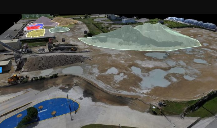
Guillaume Delepine
Aeronyde uses Skydio drones to perform accurate volumetric stockpile analysis on complex sites, enabling construction project managers to track materials usage more effectively. With Skydio 2, Aeronyde can perform stockpile scans faster, and in more complex environments, with less pilot stress.
One of the best parts of my job is talking to customers and listening to their stories about the way that Skydio 2 is changing the way they fly and in some cases, the way they fundamentally do business. Today I’m excited to share with you the story of Aeronyde Corporation, a diversified Drone Services Provider (DSP) serving various enterprise and public safety clients across the Southeastern United States. After rigorously testing over 1,000 automated missions comparing the Skydio 2, DJI Mavic 2 Pro and Enterprise, and DJI Inspire series UAVs, the Skydio 2 outperformed DJI and has supplanted its enterprise workload.
After rigorously testing thousands of automated missions across the DJI Mavic 2 and Inspire series, the Skydio 2 outperformed the manual UAVs by nearly every quantifiable metric.”- Edgar Muñoz, CEO of Aeronyde
Challenge: Manual DJI drones were inefficient, generated poor scans, and had limited applications
Manual DJI drones were hampering Aeronyde’s operations, despite having a focused team of full-time, Part 107 certified drone pilots. While a well trained pilot makes a huge difference, the shortcomings of manual drone technology fundamentally limit the effectiveness of even the most skilled operator. Aeronyde’s analysis found that 82% of inspection costs were associated with pilot spend. Manual drones were limiting Aeronyde’s growth by making jobs take longer, hurting the quality of customer deliverables, and limiting the types of jobs that the company could perform for their clients.
Solution: A next-generation workhorse
After a short period of side-by-side testing, Aeronyde has moved into a full deployment phase of the Skydio 2, permanently replacing the legacy manual systems the team previously flew. Aeronyde’s fleet has grown to eight Skydio 2 Pro Kits, and the team plans to implement the Skydio Autonomy Enterprise Foundation software package on its existing aircraft to further enhance its inspection capabilities.
Flying more advanced grid pattern flights than ever before thanks to Skydio’s partnership with DroneDeploy, Aeronyde is able to capitalize on Skydio Autonomy, which provides 360º Obstacle Avoidance, reliable GPS-denied operations, and elevated workflow automation.
“We are realizing tremendous value for our clients by using Skydio’s autonomous drones, and are looking forward to staying on the cutting edge with the Autonomy Enterprise Foundation software and upcoming X2E.” – Edgar Muñoz, CEO of Aeronyde
Results: More efficient operations, higher quality outputs, new revenue streams
Switching to Skydio has enabled Aeronyde to equip its growing team with AI-enabled tools that better help them serve enterprise customers. Their upgrade to autonomy has resulted in faster scanning, better data quality, and entire new categories of business.
- Up to 60% reduction in required flight time per job
- 8-10x improvement in image quality
- Opened new categories of indoor and low-altitude business
Aeronyde is a diversified Drone Services Provider serving various enterprise and public safety clients across the Southeastern United States
To learn how Aeronyde is generating this incredible value for their own operation and their customers, please come check out the full case study, available for download on Skydio.com. And to hear from Aeronyde directly, please check out Chief Real Estate Officer, Trevor Ragno’s, recent appearance on our Recent Webinar: Accelerating your Part 107 Business with Skydio.
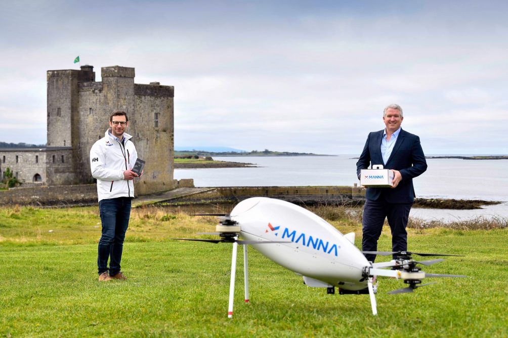
Autonomous drones are now delivering Samsung products in Ireland via the start-up, Manna. The partnership is the first of its kind.
Alan Hicks, CTO, Manna and Eamonn Grant, Head of Online, Samsung Ireland. (Credit: Andrew Downes/ Xposure)
Move over couriers, drone delivery is here. The Ireland-based start-up, Manna, will now be using their delivery drones to bring Samsung mobile phones and tablets to residents in the town of Oranmore, Ireland, in as little as three minutes.
Based out of the University College Dublin’s NovaUCD research and innovations unit, Manna has been not-so-quietly testing drone delivery capabilities in Irish towns since March of 2020. They have so far focused on food and pharmaceutical deliveries – and have specifically tested the delivery of drugs during Corona-19 lockdowns. However, the delivery of technology signifies the entry into a new frontier.
“This partnership with Samsung marks the first of its kind in the world,” says Alan Hicks, CTO at Manna. “We recognize that the potential for the application of drone delivery is enormous.”
Three-minute delivery
The delivery drones fly at an altitude of 50-80 meters and a speed of over 60 km per hour. This means that deliveries can go from a business to someone’s front door in about three minutes, assuming they are within a two-kilometer distance from it. They are also autonomous, though Manna employees are currently monitoring deliveries closely by going to the recipient’s house in person during deliveries while they continue to test the drones.
Manna customers can order their products online and then wait for the drone to arrive, typically, in their gardens. It signals the recipient that it has arrived and then descends to about a 15-meter height before lowering the product down with the help of a biodegradable string.
A work in progress
 Screenshot taken from Manna website.
As of now, the weight limit for a package is two kilograms. This works well for lighter products such as phones, food delivery, and pharmaceuticals, but would be difficult to use for anything much larger.
What is particularly relevant for people who live in areas that suffer more from rain and wind, is that the delivery services seem to stop working outside of very mild weather conditions.
At the time of writing, the website is unable to take deliveries due to forecasts of “bad weather.” It is unclear whether it is the weather or the technical limitations of the drones that is causing the delivery stoppages. However, AccuWeather is forecasting “a little rain” and 37 km winds on the dates in question, which, according to the Beaufort scale is between a moderate and strong breeze -enough to make small trees sway.
By Alex Davidson