Blog entry by Bruce McPherson
Anyone in the world

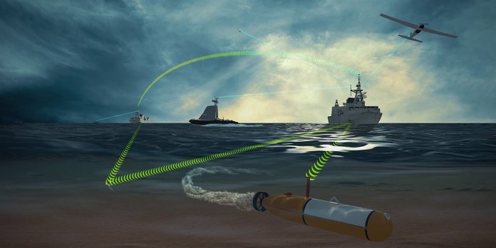
| A team of autonomous industry experts lead by Kongsberg Geospatial along with Four DRobotics Corp and SeeByte have been contracted by Weir Marine Engineering to develop and test a Maritime Multi-Domain Control System (MMDCS).Ottawa, ON – Team Cohort, a team of autonomous industry experts comprising Kongsberg Geospatial, Four DRobotics Corp and SeeByte, have been awarded a contract from Weir Marine Engineering to develop and test a Maritime Multi-Domain Control System (MMDCS). The system will allow operators to simultaneously operate multiple autonomous vehicles in the air, on the water, and underwater – all from a single shipboard control station. The system could allow Royal Canadian Navy (RCN) warships to effectively extend their sensor range using autonomous vehicles, while providing protection from seaborne threats such as mines or hostile unmanned craft. The MMDCS is a challenging project that requires experience with the deployment of autonomous unmanned vehicles, and operations of maritime control stations, as well as existing and emerging NATO standards including Stanag 4586 and 4817. This specialized knowledge and expertise is provided by the team of Kongsberg Geospatial and Four DRobotics Corp of Ottawa, Canada, and SeeByte of Edinburgh, Scotland. For this project, Kongsberg Geospatial will provide operator control stations based on its IRIS UxS vehicle command and control software product – which provides an overall real-time picture of the terrain, airspace, and underwater environment where the ships and their supporting UxV (Unmanned [X] Vehicle) teams are operating. Four DRobotics Corp and SeeByte will provide goal-based mission planning and reasoning (AI-supported) software systems to support autonomous mission development and execution for a UxV team consisting of an Unmanned Aerial Vehicle (UAV), an Unmanned Surface Vehicle (USV), and an Unmanned Underwater Vehicle (UUV). The MMDCS will provide a tactical capability for the command and control and information management required to simultaneously support unmanned vehicles in all three naval operations domains, including air, surface, and sub-surface. The final objective of the project is to provide real-time or near-real-time situational awareness for warships in all three domains: underwater, on the water, and in the air – allowing improved threat assessment and target engagement. The development and testing of the prototype MMDCS is expected to be completed by mid 2021. |
| Background Maritime Multi-Domain Control Station (MMDCS) The MMDCS will provide a tactical/force level capability for the command, control and information management to support marine vehicle types in all three naval operation domains air, surface, and sub-surface. Primary purpose of the contract is to establish the requirements for an MMDCS advanced development model (ADM) to Technology Readiness Level 5-6 for the Halifax and Kingston-class but also considering the RCN future fleet such as the: Harry DeWolf-class, Protecteur-class, and the Canadian Surface Combatant. The focus of the ADM is on operations. Ideally, all major vessels of the RCN could employ the MMDCS. The objective is near real-time generation of situational awareness in the maritime domain battlespace as well as decision support tools for mission-planning, data exploitation, real-time platform and sensor deployment, threat assessment, and target engagement using automated processes to assist human decision-making across all three maritime domains: underwater (UUV), on-the-water (USV), and well above the water (UAV). NATO Stanag 4817 Multi-Domain Control Station NATO Stanag 4817 is a protocol that is in development by NATO member countries Partners for Peace (PfP), and Israel. The purpose of 4817 is to support common interoperability between a Ground Control Stations and unmanned vehicles in all domains including: air, sea, underwater, and ground. 4817 is a successor to NIAG studies NIAG SG-157 and NIAG SG-202 and is compatible with NATO Stanag 4586. About Kongsberg Geospatial: Based in Ottawa, Canada, Kongsberg Geospatial (http://www.kongsberggeospatial.com) creates precision real-time software for mapping, geospatial visualization, and situational awareness. The Company’s products are primarily deployed in solutions for air-traffic control, Command and Control, and air defense. Over nearly three decades of providing dependable performance under extreme conditions, Kongsberg Geospatial has become the leading geospatial technology provider for mission-critical applications where lives are on the line. Kongsberg Geospatial is a subsidiary of Kongsberg Defence Systems. Media contact: 1-800-267-2626 or reach us by email at info@kongsberggeospatial.com About Four DRobotics Corp: Formerly known as Cohort Systems Inc., Four DRobotics Corp is based in Ottawa, Canada. Four DRobotics Corp https://www.fourdrobotics.com/ is a Canadian owned small medium enterprise with business development offices in Ottawa and Beloeil, Quebec. The company develops autonomous vehicles that employ Goal Based Reasoning and Deep Learning for the Autonomous Vehicles as a Service business model. The company is focused on the application of this business model to the physical security of critical infrastructure. Media contact: (613) 806-8007 or email Clinton Joseph at clinton.joseph@fourdrobotics.com, or info@fourdrobotics.com. About SeeByte: Headquartered in Edinburgh, Scotland, SeeByte (http://www.seebyte.com) has achieved a position of leadership in the development of smart software for underwater vehicles, sensors and systems in both the Military and Oil & Gas sectors. SeeByte provides products and services to major government and commercial clients around the world. SeeByte is a subsidiary of Battelle. Battelle is a leader in maritime technologies; enabling rapid development and deployment of solutions for government and industry. |