Map large projects at centimeter accuracy with an Aeromapper Talon and Reach M2 PPK UAV Mapping Kit
Multiply your productivity and save money and time on large projects by adding the Reach M2 UAV PPK Mapping kit on your next order of an Aeromapper Talon!
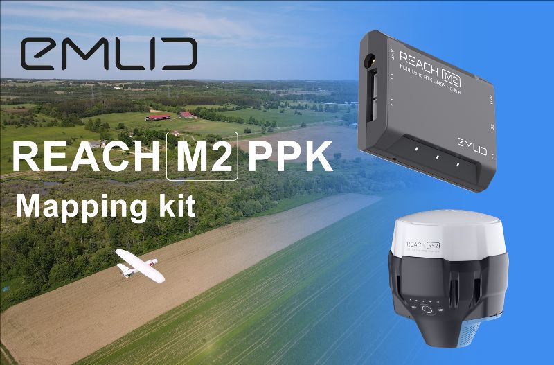
The Reach M2 PPK UAV Mapping kit consist of the Reach M2 Multi-band GNSS receiver onboard the aircraft that records the location of each photo at a frequency of 20 Hz. It is combined with the Reach RS2 GNSS multi-band receiver on the ground, drastically reducing the number of ground control points (GCPs) and simplifying the setup process on-site, while maximizing the accuracy to centimeter levels even in remote areas. The M2 tracks GPS/QZSS (L1, L2), GLONASS (L1, L2), BeiDou (B1, B2), Galileo (E1, E5) and SBAS (L1C/A) and gets fixed solution almost instantly. Reach M2 allows working over longer baselines of up to 100 km in PPK mode.
Reach RS2
The Reach RS2 is a multi-band RTK GNSS receiver designed for surveying, mapping and navigation. Reach RS2 gets fix in seconds and provides positional accuracy down to a few millimeters. The receiver tracks GPS/QZSS (L1, L2), GLONASS (L1, L2), BeiDou (B1, B2), Galileo (E1, E5) and reliably works in RTK mode on distances up to 60 km, and 100 km in PPK mode. Multi-feed antenna with multipath rejection offers robust performance even in challenging conditions.
RINEX raw data logs are compatible with OPUS, CSRS-PPP, AUSPOS, and other PPP services so you can now get centimeter-precise results in any place on Earth.
Designed for tough conditions
Reach RS2 is engineered to be waterproof and impact-resistant. The body is manufactured in a two-step injection process and is made out of shockproof polycarbonate covered in a special elastomer for extra protection. The receiver has an industry-standard 5/8’’ mounting thread.
The LiFePO4 battery is designed for 16 hours work as a 3.5G RTK rover on one charge regardless of weather conditions. No need to carry spare batteries. Reach RS2 can charge from a USB wall charger or a power bank over USB-C. An RS232 interface allows to you to connect Reach RS2 directly to external hardware and output positioning in NMEA.
Aeromapper Talon
The Aeromapper Talon is a Transport Canada Compliant - fixed wing survey unmanned vehicle that allows data collection of large areas (of approx. 7-8 km2 per flight) @ 2.4cm per pixel, and combined with the Reach M2 PPK UAV Mapping kit makes the ultimate tool for gathering quality data for large projects where maximum accuracy is king.
BVLOS ready and ADS-B equipped
Since its initial release in 2014, the Aeromapper Talon has evolved as a dependable piece of equipment that is aimed to keep the user’s operational costs as low as possible while maximizing its productivity. With this philosophy in mind, this drone has been used quite often for BVLOS capabilities by many clients around the globe. It provides a solid long-range communications link and its is now equipped with ADS-B capabilities which allows the operator to receive flight information from manned aircraft within a 100km radius.
Several payload options are offered including all Micasense sensors, a 36 Mp RGB camera, Thermal and video downlink for monitoring.
To learn more click here
Explore other variants of this fixed wing drone:
Aeromapper Talon LITE
Aeromapper Talon Amphibious
|
|