User blog: Bruce McPherson

MVT Geo-solutions, in partnership with Iris Automation, has been granted the first Beyond-Visual-Line-of-Sight (BVLOS) Special Flight Operations Certificate (SFOC) by Transport Canada using only onboard Detect-and-Avoid (DAA). The approval was granted based on the utilization of Iris Automation’s DAA system, called Casia, which provides commercial drones with automated collision avoidance maneuvers.
The waiver permits flights within the Unmanned Aircraft Systems (UAS) Center of Excellence’s controlled airspace Remotely Piloted Aircraft System (RPAS) test range in Alma, Quebec. This is the first BVLOS flight at the location leveraging only onboard DAA for air risk mitigation, and does not require ground-based observers or radar.
BVLOS flights unlock autonomous drone use for economically beneficial commercial applications including infrastructure inspection, mining, mapping, agriculture, emergency response, and package delivery. “Achieving the first BVLOS approval in Canada further validates our technology alongside multiple permissions we have already received from regulators in the U.S. and South Africa,” said Iris Automation CEO Alexander Harmsen.
”This technology is critical to safely integrate drones into the airspace along with manned-aircraft, and we look forward to unlocking commercial operations for our customers in Canada.” Iris Automation’s onboard computer-vision DAA system is the most effective, scalable, and cost-effective technology to enable commercial BVLOS operations.
“The UAS Center of Excellence is looking forward to leveraging Iris Automation’s industry-leading DAA system and existing flight expertise within our network to conduct BVLOS flights with MVT Geo-solutions,” said UAS Center of Excellence Director William de Keiser. “We will continue to develop our partnership with Iris Automation to provide training to local operators and enable BVLOS flights in Canada.”
The first BVLOS flights are scheduled to take place within weeks. The resulting data will inform more complex BVLOS operations in the future.
About Iris Automation:
Iris Automation is building a computer-vision-based avoidance system that helps drones see the world how pilots do. Founded in Canada, the company is based in San Francisco and is led by a team with experience at NASA, Boeing, and Nvidia, including PhDs in computer vision. Iris is a key partner on multiple U.S. FAA UAS Integration Pilot Programs, a participant of NASA’s Unmanned Traffic Management program and a participant of Transport Canada’s BVLOS Technology Demonstration Program.
Learn more at www.irisonboard.com
By Press
RangePro X8P (Pixhawk), the follow-up to the RangePro X8, is proudly designed and manufactured in the USA, with U.S.-made flight control system (FCS) components and highly secure radio options
Valencia, CA ( March 24, 2020 ) — TerraView, a California-based unmanned aircraft system (UAS) development and manufacturing company, today unveiled the RangePro X8P – Pixhawk, a follow-up model to last year’s RangePro X8, now with system components and options that meet federal government and Department of Defense (DoD) guidelines. Like its predecessor, the RangePro X8P is an enterprise unmanned aerial vehicle (UAV) designed to fly for more than 70 minutes in real-world conditions with a standard sensor payload. Proudly engineered and manufactured in the USA, the RangePro X8P is designed specifically for industrial, first responder, and government enterprise data capture.
“We designed the RangePro X8P based on U.S. market and federal government demand, aligning with the pending U.S. Senate bill, S.2502, the American Security Drone Act of 2019. If this bill is passed it will ban federal departments and agencies from purchasing any commercial off-the-shelf drone or unmanned aircraft system manufactured or assembled in China or other countries identified for national security concerns,” said Bruce Myers, president of TerraView. “We have been working with suppliers in the U.S. and other U.S. partner countries to provide best-in-class technical solutions and components that allow us to manufacture one of the highest-performing commercial drones in the market today.”
“As a follow-up to the RangePro X8 that we launched last year, the RangePro X8P still employs the same airframe and military-grade technologies that provide for its extended flight time but now with a US made flight control system (FCS) and other non-Chinese system components and data capture options,” added Myers. “The new model includes a ground control station (GCS) option with encrypted radio/data, US made FLIR, non-Chinese RGB and mapping camera options at this time. The RangePro X8P ensures the competitive advantages of extended flight time with the reassurance of complete safety and security of valuable data.”
Compared with competitors, RangePro X8P offers:
Customization Options: The unique capabilities of the RangePro Pixhawk can be customized to work in industries such as energy, agriculture, construction, first responders, mining, and government, to name a few.
- Longer Flight Times: Its highly efficient design coupled with higher power density batteries result in flight times that are on average two and a half times longer than the competition, allowing users to accomplish more work with fewer batteries and less time spent on battery swaps and maintenance.
- Longer Service Life: Not only does the RangePro Pixhawk fly longer, each battery can support over 500 charging cycles over its useful lifespan.
- Lower Total Cost of Ownership: Longer flight times, longer service life, and efficient design combine to provide the lowest cost per flight hour, keeping a low total cost of ownership and increasing overall ROI.
The RangePro Pixhawk has data capture capabilities that include:
- Structural Integrity Surveys
- Terrain Mapping and Modeling
- Construction Site Planning
- Solar Panel Inspections
- Pipeline Inspection
- Tower Inspections
- Power Line Inspections
For more information on TerraView, visit https://terraview.com
By Press
At present, 170 countries are affected by the pandemic, COVID-19. The rate of infection continues to rise fivefold on a daily basis across the world, and the data continues to highlight the transnational force of contagion. To date, there is no unifying or effective method to treat the disease or its spread, which would need the capacity to reach and save an estimated 5.3 billion people who are expected to contract the illness in the coming months.
The COVID- 19 pandemic we face currently is an important reminder of the power of infectious diseases.
But, in the midst of all this doom and gloom, the COVID-19 pandemic has highlighted some important lessons for the global health sector. It offers a critical insight into how innovation and advanced technology may better equip and support us as we tackle this global pandemic and handle public health emergencies to contain, mitigate and eradicate the spread of infectious diseases globally.
A tailored global response to COVID–19
Yesterday, Swoop Aero took a leading role in global health transformation. We became the first drone logistics company globally to operate a fleet of aircraft from outside the country of operation. We have deployed this capability in order to support the Malawian national government’s health system as they commence their response to the pandemic. With the backing of the College of Medicine and the Malawian Department of Civil Aviation, our ground operations teams, staffed by local Malawians that have been trained over the last few months, made this possible. There were no members of the Australian flight operations team present, as they have all returned to Australia to comply with the government’s travel strict restrictions. The goal of this remotely piloted operation is to support the government’s COVID-19 response following reports of an acceleration of reported cases across the country. It means that our local Malawian ground operations teams are not losing their jobs at a difficult time for the economy. In addition, at a time when normality has been suspended for most, this means that we can continue routine flight operations in our network, delivering essential healthcare supplies for pre-existing communicable diseases, such as HIV/AIDS, malaria and TB.
This unprecedented step forward in the aeromedical drone logistics sector is a testament to the incredible technology of the Swoop Aero system; and, the reality of being able to execute this safely is a testament to years of hard work in ensuring the system meets the highest aviation standards. The Swoop Aero Control Platform remains the primary interface for the coordination, management and automation of the physical aircraft. In addition to piloting the flights, the software also manages the coordinated efforts of local Malawian team members and Australian staff to conduct flights safely, in accordance with industry regulatory standards. The Control Platform ensures that all flights can be safely piloted from anywhere in the world to ensure the aircraft safely follows the correct flight route, with speed, precision and reliability, and thus, reaches the specified location on time to deliver essential supplies. Furthermore, this system gives Swoop Aero team members an ‘eye in the sky’, an Air Traffic Management platform, to oversee the local airspace and manage multiple flights at any one time, in order to safely achieve the best possible outcomes for the health system. . Our continued efforts in this challenging period will have sustained benefits for the Malawian population and have demonstrated the sustainability, longevity and adaptability of the network to operate in a host of challenging and unforeseen circumstances.
Why is this necessary? Africa’s vulnerability to infectious diseases
THERE IS “REAL FEAR THAT HEALTH SYSTEMS BECOME SWAMPED AND UNABLE TO MANAGE THEIR ONGOING HEALTH CARE, THEREBY PRESENTING AN EVEN GREATER THREAT THAN THE VIRUS”.
Trudie Lang, Director of the Global Health Network at Oxford University
The significance of this pandemic is increased by the challenges faced by the global health system to cope with a new disease outbreak. Malawi is identified within the geographical region termed the “disease hot spot belt”. As identified by Trudie Lang, Director of the Global Health Network at Oxford University, there is “real fear that health systems become swamped and unable to manage their ongoing health care, thereby presenting an even greater threat than the virus”. The continuation of the Swoop Aero air transportation service to assist the government and alleviate some of this burden, has allowed routine and emergency measures to remain in place. The intention is to scale up the size of the drone network to facilitate more flights per day. Each flight undertaken carries a cargo payload of 3kgs, which represents between eight and ten COVID-19 testing kits per flight which are able to be delivered easily into a remote village, without risk of infection. The integration of COVID-19 tests and samples, alongside our continued medical commodity transportation services, helps to strengthen the local health supply chain effectively during a period of increased demand for the health sector and associated resources.
Air transport using drones will increasingly become integral in maintaining open health supply chains to transport essential medical commodities, which can effectively service vulnerable populations forced into isolation. The aeromedical logistics solution that Swoop Aero has developed eradicates the need for human-to-human contact within the delivery process as the flights and operational procedures of the aircraft are coordinated and managed remotely. We also have a range of proven procedures designed to address decontamination in a time of crisis such as the present. The multi-network fleet of Swoop Aero aircraft offers the most viable and effective solution to administer a mass number of COVID-19 tests, transport essential healthcare supplies to remote and elderly populations that are running low on routine products, and facilitate the continued operation of the global health sector to minimize the additional strain of preventable illnesses on an already stressed global health workforce and resource pool. From Africa to Australia, this solution remains cost-effective, viable and proven to deliver.
By Press
The fight against Covid-19 is much more in the air than you actually think
My grandfather fought the Second World War. He was part of the Italian resistance movement but he was not a soldier, he was just one of many regular people. Still, he was imprisoned in an internment camp, but he made it home at last.
Second World War was the fight of the regular people of his generation. The fight of my generation’s regular people consists of avoiding contagion by staying on the couch, watching as much Netflix as possible and resisting the impulse of compulsively buying toilet paper. Also, we are getting fat. Extra-fat. Pretty nice fight, huh?
I hate this situation, because I want to do something but actually, “doing nothing” is the real good thing to do. But still, I can’t watch indifferently many grandparents of Italy dying defenselessly, grandparents that fought for our country, while I binge watch for the fourth time Breaking Bad. I know I am talking a lot about Italy, but this applies to any other country living the Covid-19 emergency.
In this fight against such a powerful invisible enemy, there is still so much we can do. The only way “non-medical” people have to support who is fighting this war on the front line is having effective confinement: “Stay home!”
While technology is perfectly entertaining us at home, there is still so much it can do to help us win.
Drone delivery could improve substantially the situation, by providing medicines, goods and so on to the people that cannot or should not move from their home. The exchange of viruses and thus the propagation of Covid-19 could be strongly limited. Remember, our enemy acts “exponentially”: we need great means to fight it. Any.
Drone delivery tech is already available today, but, there is still a big blockage point that doesn’t allow its usage: regulation.
Civil aviation regulators around the world have not figured out yet completely the legal framework to integrate drones into the air traffic. They claim that drones have the potential of being very dangerous for the current air traffic. True, I know. In the meantime, drones are not anymore an unknown technology, including for regulators. Drones are here to stay, and that is a fact. Also, the industry has already brought on the table all technology to safely integrate them into the air traffic (UTM, U-Space, deconfliction, and so on). There have been several technical demonstrations around the world, also companies that are already providing drone delivery commercially, saving lives today (Zipline, Matternet, and so on…), thanks to regulators that have demonstrated more flexibility (Switzerland, Rwanda, and so on…).
Unfortunately, these remain exceptions. We can all agree that drone delivery is not yet here today because of the speed of our regulators, for the too much talking, for the not converging, for the lack of flexibility, for the willingness of doing “the same law in every country from day zero”, for the hopeless research of a “technology that will solve all the problems”. Compromises have to be done.
Interestingly, regulators can also be extremely fast and reactive. Every time there is a major commercial aircraft crash, for a cause that was not foreseen, regulators can run and change laws “almost instantaneously”, worldwide. We all remember how fast measures were taken after 9/11, or after the crash of the Germanwings, or after the crash of the two 737 MAX, to cite some examples.
Maybe this is the key to speed up things?
So let’s see things this way. Today is the 21st of March 2020. Below, a graph showing the death toll in Italy in the last week due to Covid-19, but in “number of commercial aircraft” (I’m considering, for example, a standard commercial aircraft with 180 passengers), instead of number of people:

From the beginning of the epidemic, we have today 4.035 deaths, corresponding to 22 commercial aircraft, only in Italy. I am scared while I am writing this down. It is huge.
Drone delivery together with confinement has enormous potential to decrease the spreading of the virus. Remember this fight is exponential. Infected people are both victims and the virus’s army. Every non-infected counts.
So regulators, please,
- if you are worried about the danger drones could bring to other air traffic, just don’t, the sky is way less busy today.
- If you are worried about the danger of flying drones over people, just don’t, everybody is safe at home.
- If you are worried about noise complaints due to drone flights, just don’t, everybody is on their balcony doing a lot of noise too. Noise means we are still alive.
The potential of this technology is so massive and the situation is so bad, that even in the remote possibility that a drone hurts somebody, the balance is still totally in favor of using it.
I feel so bad that this tech is not available for everybody already today, and even if drone delivery is unblocked now, we will need some time to set things up.
The time to act is now, do it for all the grandpas of Italy and all over the world, that fought for us.
Manu Lubrano, Ph.D.
CEO and Co-Founder, INVOLI AG
By Manu Lubrano as found in sUASNews
The use of drones on construction sites increased by 239 per cent from 2017 to 2018, according to DroneDeploy, a leading drone software platform. This rapid growth is part of a global commercial drone market that Goldman Sachs estimates will be worth $100 billion this year.
Drone usage is exploding for the simple reason that it can provide more detailed information, job tracking and communications at costs that can’t be met on the ground. DroneDeploy cites the example of Rogers-O’Brien Construction, a leading general contractor in Texas. The company reportedly saved thousands of man-hours, increased efficiency, avoided costly budget overruns, and reduced inspection costs by 99 per cent.
Yet, moving drone integration from concept to execution is a multi-step process requiring commitment. Many companies remain parked on the sidelines because they lack a plan for moving forward.
Joao Antunes, writing on behalf of the AEC-NEXT Technology and Apps Conference (June 3 to 5, 2020), says any consideration to initiate a corporate drone program relies on several factors. It begins with a detailed assessment to determine whether drones are, in fact, the right tool to solve the company’s data-gathering problem.
Skyward, a Verizon company offering drone consultancy to various industries, suggests that company insiders proposing the adoption of drones first need to secure a buy-in at the executive level. This is best achieved by finding what Skyward calls “an initial use case” — a pilot project — that can measure the benefits drones could provide.
Management’s decision whether to then move forward, and on what basis, will be based on a thorough examination of costs versus benefits. Many questions need to be asked:
- Would drone technology result in a competitive advantage?
- What would the standardized procedures accompanying the use of drones look like?
- How would the data gathered by the drones be analyzed?
- Can that data be shared among various project team members and partners without severe disruption of current protocols?
- What are the potential project risk reductions?
- What are the costs of postponing the decision to adopt drones until next year?
- Most importantly, should the company invest in its own program or outsource its aerial monitoring needs?
Outsourcing to third party providers makes sense in specific circumstances, says Antunes. “These types of companies can be leveraged for their existing infrastructure or expertise, which can contribute to cost savings. They may be especially useful for unique or one-time projects that would benefit from drone use but may not (yet) be worth investing in a suite of new technology for the construction company to own.”
If the company chooses instead to bring a drone program in-house, the “suite of new technology” referred to by Antunes requires a significant investment of resources and strict adherence to government regulations.
First, drone pilots working on or near construction sites must pass Transport Canada examinations in order to hold a Pilot Certificate for Advanced Operations. Several independent facilities offer the required pilot training courses should current unlicensed employees be interested. Alternately, community colleges that provide drone training programs might be a source for hiring pre-qualified pilots.
Secondly, a decision must be made regarding which of the many types of drones to purchase — multi-rotor, single rotor, or fixed-wing. Which type of sensors best meet company needs and budgets? Are cost-effective photogrammetry sensors enough, despite limitations due to flight visibility? Or do project needs call for more expensive Lidar sensors, capable of creating highly accurate 3D maps in all weather conditions and no matter what ground cover conditions exist? Whatever hardware choices are made, the drone software must integrate smoothly with the company’s workflow processes and BIM platforms.
Today’s drone mapping and monitoring technologies are revolutionizing the industry. They offer construction companies powerful ways to increase productivity through enhanced project communications, time and cost efficiencies, and improved site safety. The question is not just whether to buy or hire; it’s “How long can you hold out?”
By John Bleasby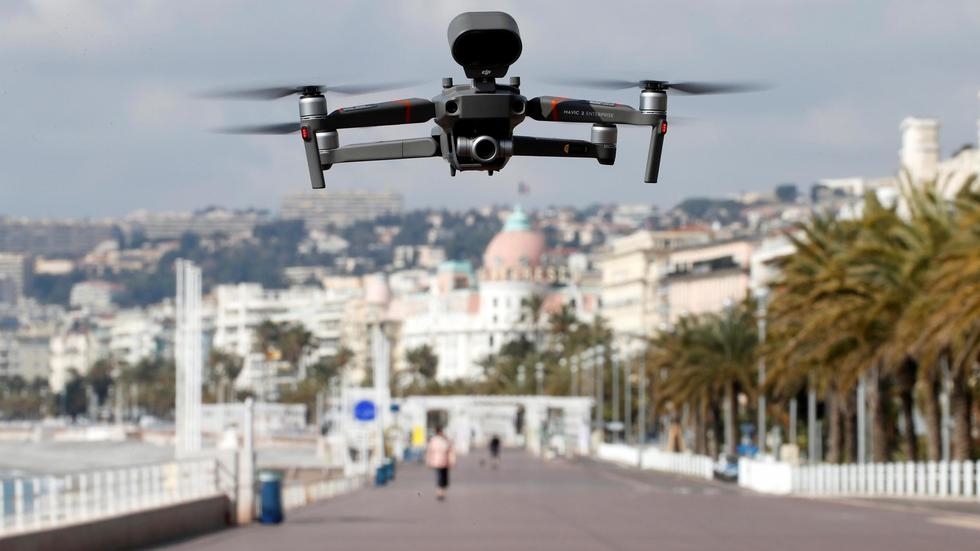
A drone used by police in action in Nice, France Foto: REUTERS/Eric Gaillard
Police in France are using the latest drone technology, as well as helicopters, to ensure that residents are staying indoors during the lockdown to stem the spread of the coronavirus.
“Helicopters will give us a larger view of the situation in real time to help guide patrols on the ground,” the National Police said.
Police helicopters have been seen throughout Paris, including near the Eiffel Tower and around parks to make sure people are not leaving their homes for non-essential trips.
France has imposed a two-week confinement order to combat the coronavirus pandemic, with a view to expanding the lockdown if necessary.
Residents are only allowed to leave their homes for grocery shopping, to go to the pharmacy, or light exercise within a two-kilometre radius of their home.
The order has affected all businesses, with people are required to work from home unless they are essential staff, including hospital workers, petrol station attendants, or grocery store employees.
Nice already under drone patrol
Police in Nice have already deployed drones to accompany police and serve as warning loudspeakers to enforce the coronavirus lockdown.
"A reminder of the instructions relating to the Covid-19 epidemic: all travel outside the home is prohibited unless exempted. Please respect a safety distance of at least one meter between each person," says the drone repeatedly, piloted by the company Drone06, owned by former police officer Sabri ben Hassen.
The police drone packs a punch: the speaker delivers the power of 100 decibels, says ben Hassen.
"By comparison, an Airbus taking off produces 120 decibels,” he adds.
Nice Mayor Christian Estrosi has already used his municipal powers to impose a 11pm - 7am curfew on the city, an initiative not yet seen in Paris or other parts of France.
France’s scientific council will make an announcement on Monday on whether to extend or expand emergency measures throughout the country, according to Health Minister Olivier Véran.
By RFI France
Agencies’ use of foreign-made drones may get harder as the Trump administration looks to ban the U.S. government from buying drones made in China or with Chinese parts. The Interior Department grounded such drones in October, and on March 11, TechCrunch reported that an executive order is in the works that would ban federal departments and agencies from buying or using foreign-made drones because of national security concerns. Additionally, lawmakers have introduced legislation that would bar agencies from buying drones made in China.
Some federal agencies are concerned about what that will mean for their operations. The Chinese firm DJI is the leading manufacturer, with 70% of the market share. “The Agriculture Department, which uses drones to survey farmland, for example, said [the ban] could limit the ability ‘to carry out our mission-crucial work’ and ‘halt’ the Forest Service’s use of drones altogether,” according to a New York Times article.
State and local government agencies are also increasingly dependent on drones. Since 2014, the number of U.S. public-safety agencies with drones has risen from almost none to more than 1,500, the vast majority of which deploy devices made by DJI, according to a new report.
The majority of drones that public-safety agencies operate are consumer or prosumer models, with the most common type being Chinese-made DJI Phantom models, which 336 agencies use. Three other DJI models -- Inspire, Mavic and Matrice -- follow at 291, 246 and 226 agencies, respectively. After that, the numbers fall considerably. For instance, the Yuneec Typhoon is the fifth-most-used model but is at only 34 agencies, according to the report, “Public Safety Drones, 3rd Edition.”
Specifically, 1,578 state and local police, sheriff, fire and emergency services agencies are believed to have acquired drones, according to a March report from the Public Safety Drones project at the Center for the Study of the Drone at Bard College. The total number of drones at these agencies is 2,826, and the average number of drones per agency is 3.9, based on those agencies with more than one drone recorded, states the report. Twenty agencies have 10 or more drones.
Seventy percent of disclosed public-safety agencies with drones are in law enforcement, the report states. On average, state law enforcement agencies have 10.6 drones per agency, county sheriff’s offices have four, municipal police departments have 3.2, and fire and rescue have three.
The states with the most drones are California, with 140, and Texas, with 115. Illinois rounds out the top three with 76.
Since the center published its last study in May 2018, the total number of counties with at least one agency that has drones has risen 45% to 899. Counties with two or more agencies that own drones is 289, up 90% from 2018. Overall, more than 500 disclosed public-safety agencies acquired drones in the past two years.
The drone center report found that at agencies for which data was available, 118 acquired their drones through donations, 80 through grants, and 53 through seizures, forfeits or other funds. Only 32 had budgeted for them.
Founded in 2012, the center hosts an initiative to track local, state and federal public-safety agencies that own drones for operational use. It says its database is the only comprehensive open-access tally of publicly disclosed public-safety agencies that are reported to own at least one drone. The database does not include agencies with undisclosed drone programs or federal agencies and therefore does not reflect the total number of U.S. public-safety agencies with drones in the U.S. Additionally, it does not include agencies that use drones owned by other entities or private citizens.
BY STEPHANIE KANOWITZ
The speakers can be heard blaring messages like: "Travel is prohibited unless there are exceptional circumstances." or "Please respect the safety distances." Business Insider France / Pixabay
In February, videos of drones flying over Chinese cities and giving orders out to citizens about staying at home or wearing masks flooded the internet.
China, then in a state of emergency, was hit hard by the first wave of the coronavirus epidemic.
A month later, several European countries declared public health emergencies and started imposing lockdowns to limit the spread of the virus.
After Spain began to employ manned loudspeaker drones on March 15, France has been quick to follow.
On Thursday March 19, a drone was seen flying over Nice's city center and main roads at around 2:30 pm, urging people to comply with containment measures.
The speakers can be heard blaring messages like: "Travel is prohibited unless there are exceptional circumstances." or "Please respect the safety distances."
The company responsible for the drones, Drone 06, explains on its website that it specializes in aerial photography using civilian drones.
The private company, based in Nice, offered its services to the region's law enforcement, so there are now small drones flying over the city.
Each drone weighs in at 800 grams (about 1.7 lbs) and measures 30 centimeters (about a foot) in diameter, a company spokesperson told Le Parisien.
According to local publication, Nice Matin, the devices are being trialed in Nice and will then go on to be tested in other towns in the region.
Authorities in the region Nice is situated, Alpes-Maritimes, suggest that lockdown measures have been taken far too lightly in the area.
The use of drones comes with a view to aid law enforcement implement lockdown measures more stringently in days to come.
Access to the beaches in the region will also be restricted, according to a regional announcement made on Thursday, March 19.
The mayor of Nice, Christian Estrosi, said: "I am even considering curfew measures."
Megan Bourdon and Ruqayyah Moynihan, Business Insider France
Hacked drones are breaching physical and cyberdefenses to cause disruption and steal data, experts warn.
Drones are a growing threat for law enforcement and business security officers. In the run-up to Christmas 2018, rogue drones grounded planes at London Gatwick, the UK’s second-busiest airport. But, increasingly it’s not just the air traffic controllers sounding the alarms over drones, it’s also the cybersecurity community.
Drones are already being used as one component of cyberattacks, Tony Reeves, a director at consulting and training company Level 7 Expertise, and a former officer in the UK’s Royal Air Force.
With drones costing from as little as $30 to $10,000 or more for specialist professional models, Reeves said, they can be used for any number of different style attacks.
Low cost and easy to use, drones can deliver a “payload” to carry out surveillance, to capture data, or to disrupt networks. Making matters worse, drones are hard to detect and defeat, he said at the recent CRESTCon ethical-hacking conference in London.
Reeves’ firm is unusual in combining cyberdefense work with expertise in intelligence gathering and unmanned aerial vehicles, and plans to use drones as part of an ethical penetration testing program.
“Drones are disruptive, not least because they bring a rapid reduction in the skills operators need,” he said. “You would crash an old-style remote control plane in 30 seconds, if you had no training. But kids can fly today’s drones.”
Law-enforcement agencies and aviation regulators are increasingly concerned about the risks posed by drones. They poses an unacceptable risk to jetliners. The heavy lithium-ion batteries in drones could puncture the skin of an aircraft wing, or smash the blades in an engine. Groups in Syria and Iraq have used modified remote control aircraft as flying bombs.
Cutting Holes in Geofences
In the case of the Gatwick airport incident, UK authorities responded by deploying military antidrone defense systems. The details have not been made public, but essentially it extends the no-fly area around airfields. One way authorities inforce these no-fly drone zones is with geofences, a type of software-level device programing that restricts where a drone can fly.
Off-the-shelf drones are being fitted with geofencing software, so that owners cannot fly them over airports or other restricted areas. DJI, the market leader, has geofencing for airports, prisons and nuclear power plants. Parrot, the No. 2 manufacturer, also has geofencing in its ANAFI software, but pilots can turn it off.
Rogue operators could, of course, build a drone themselves without any geofencing hardware or software. Or they could turn to basic hacks.
“We are seeing some leakage of tactics and information from Islamic State operations in Syria, where they defeated geofencing by denying the drone a GPS signal by wrapping it in tinfoil, and flying manually,” explained Reeves.
“There is a Russian website – on the open internet, not the dark web – that offers hacks for all DJI products. This apparently removes geofencing, altitude and speed limitations. If the Russians can do it, then it’s a fair call to believe that a committed Western hacker could do the same.”
“Equipment is now available to hack drones so they can bypass technology controls,” warned James Dale, a cybersecurity expert at PA Consulting, a firm with both aviation and cyber practices.
“There are now regulatory controls, in some regions, to force drone operators to use geofencing systems,” Dale said. “Yet, there are examples of online vendors selling software and hardware modifications for drones, which are designed to disable these ‘No Fly Zones’ limitations.” The threat from these hacks will only grow as regulators make more use of geofencing-based no-fly zones. Large sporting events or protests are just two occasions where regulators already restrict drone flights. They are likely to automate the restrictions if they can.
Some drone owners will view this as a challenge. Reeves categorizes these users as “disruptive enthusiasts”: drone owners willing to break the rules to obtain a cool shot or video footage. Other motives are more sinister and include crime, terrorism or nation-state actors such as intelligence services.
Spy in the Sky
Using drones is a low cost and simple way to gather information. Intelligence services can call on satellites and other high-end tools, but an off-the-shelf drone can capture video, photos and audio right out of the box. With a few modifications, a drone becomes an electronic surveillance tool, too.

“There are plenty of reports to be found of individuals or organizations building or modifying drones to carry RF-based payloads including Wi-Fi tracking, capture and access capabilities – predominantly using Raspberry Pi and Wifi Pineapple devices, but also 2/3/4G network devices,” explained Reeves. Bluetooth sniffing is also possible.
Putting a Wi-Fi access point on top of a building, or inside its perimeter, could allow hackers to listen in to data traffic. Drone operators could also drop a sophisticated microphone into a restricted area for eavesdropping, if technicians can overcome issues of power, weight and range. “Our judgment is that this is more the province of a corporate espionage operative than the average hacker,” said Reeves.
Security teams need to develop new techniques to monitor drones, and to keep sensitive information safe. Good IT security practice, including scanning for unauthorized access points, will help. But organizations will also need to look at everything from keeping window blinds closed, to how to detect and disrupt drones.
“The main security risk from drones is still their ability to bypass traditional physical controls by breaching fences or accessing the top floor of an office,” said PA Consulting’s Dale.
Down to Earth
Unfortunately for the defenders, drones are hard to spot, and even harder to disrupt. Drone features that appeal to consumer and professional operators make them a difficult target: They are smaller and quiet, and designed to overcome radio frequency interference.
“Drones have low acoustic and thermal signatures, and low-power RF transmitters,” explained Reeves. “On a radar, they look like birds, and air traffic control radars are designed to ignore birds.”
Drones are also fast, and their transmission systems use a range of frequency-hopping techniques to maintain a good link to the controller. This makes the data link between the operator and drone user hard to detect, and even harder to disrupt.
For now, law-enforcement agencies and businesses are unable to take over and capture or land rogue drones. Jamming the signal is possible but illegal in much of the West, including the UK and the US, with a few exceptions for government and military agencies. (Palm Beach, Florida–based lawyer Jonathan Rupprecht has compiled a comprehensive study of US federal counterdrone lawU).
That leaves more forceful countermeasures.

Rheinmetall Defence’s anti-drone laser. Image courtesy Rheinmetall Defence
Both manufacturers and law enforcement agencies have experimented with techniques involving drones or guns deploying nets, and even birds of prey. At the other end of the spectrum, German company Rheinmetall Defence has developed antidrone lasers that can be mounted on a truck or an armored vehicle.
But lasers, jamming or even lower-tech measures such as using a sniper to bring down a drone raise other issues, especially over populated areas and airports.
For now, the best defense against drones – for law enforcement and corporate security teams – remains to find and deter rogue drone operators.
“Organizations should conduct threat-modeling exercises to identify and understand the potential threats. They should consider ‘what-if’ scenarios involving drones such as a rogue access point being dropped on the roof, or the CFO’s laptop screen being filmed through the window. They then need to work out how to protect themselves from these events and how to react,” said PA Consulting’s Dale.
“As with the internet and cybersecurity, the positive and negative use of drones are two sides of the same coin and as such, you can’t have one without the other,” added Reeves. “What is certain though, is that security planning will by necessity have to include the dimension of altitude. That will have far-reaching effects.”
Manual rebar tying tasks can now give way to a more modern solution: Drones that automate the process for concrete flatwork and other slabs.
The SkyTy solution from SkyMul consists of a control station and a swarm of drones. The swarm size can be varied with the size of the jobs and the schedule for completion. The operator identifies the rebar installation
Each drone can land, tie and take off independently. Source: SkyMularea that needs tying and a divided section of the work area is then assigned to each drone. After the percentage of ties (50%, 75%, 100%) and the pattern for tying is selected, multiple drones are deployed.
The drones fly over the rebar and identify rebar intersections without using CAD files or programming utilizing computer vision technology. They identify the untied intersection, land, tie and take off toward the next intersection, and each return to the landing station for spool and battery replacement.
After tying completion, the SkyTy control station generates a report of the successful ties for quality control. One trained technician performs the tying job done by multiple rodbusters, freeing up personnel to do other critical tasks for rebar installation.