Site blog
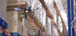
The idea of using robots for inventory isn’t new – and drones are becoming increasingly common in warehouses. Singapore’s Dexion Infinium Scan System claims to be the world’s first practical autonomous drone stocktaking system, successfully deployed since 2017.
In the midst of the COVID-19 crisis, however, inventory drones and autonomous systems for stocktaking and warehouse management have become more critical. In an effort to maintain continuity with fewer onsite staff – and less contact between them – Chevron Oronite, Asia’s largest producer of lubricant additives, has deployed Infinium Robotics‘ inventory drone solution.
Chevron Oronite has “just inked a three-year contract with Dexion -Infinium Scan System deploying an autonomous drone and a ground robot to conduct safe and cost-effective automation of inventory counts,” says an Infinium release. “The Dexion Infinium Scan™ Inventory Management Robotics System, as it is called, is an ideal solution during this unprecedented crisis where warehouses are working with limited manpower and yet having to abide by safety distancing and business continuity protocols.”
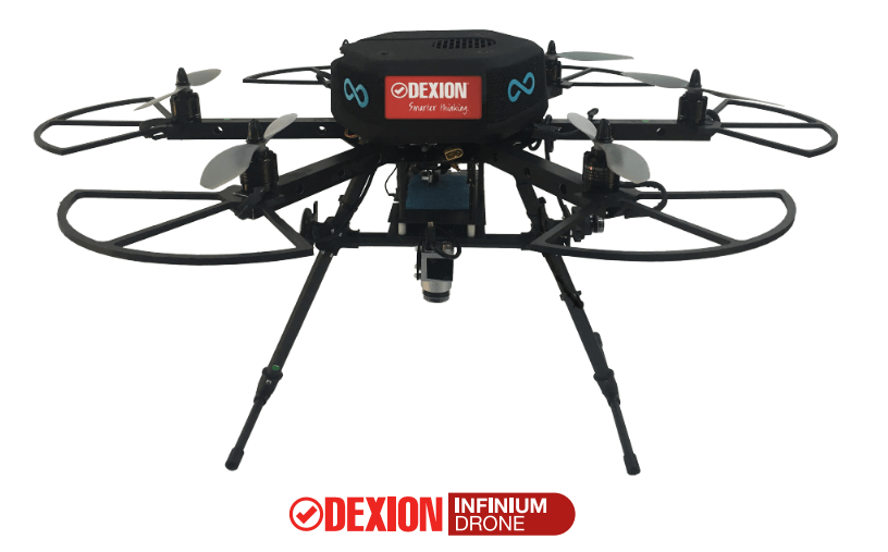 Wong Su Leong, Team Lead, Procurement Operations of Chevron Oronite Singapore, said: “With the Infinium Scan Inventory system, we have drastically reduced our costs and time in stocktaking. What could take days to complete, can be completed in hours with the automated drone stocktaking system.”
As warehouses face a new normal of stocktaking with reduced manpower, companies are increasingly turning to automated solutions. Inventory drones and robots were always a great idea: but the current crisis is forcing companies to explore technology in order to maintain efficiency and worker safety.
Infinium Robotics CEO Woon Junyang said: “We’ve seen an uptick in demand as more warehouse operators look towards automation to meet the Covid-19 challenges and ensure a healthier and sustainable New Normal for their businesses.”
Operationally, Junyang pointed out, the case for robotics in inventory management was clear-cut — inventory accuracy of up to 99.99 % and full stocktaking (wall-to-wall) during off-peak hours or closed-hours, thus not disrupting operations nor suffering any operational downtime for the company during the stock-take periods.
The inventory can also be archived in videos and images that are recorded in real time for review by inventory owners and auditors. Stocktaking time can be reduced from one week (with thousands of man-hours) to less than a day.
Junyang stresses that higher inventory accuracy leads to more optimized inventory levels: which can eventually lower the cost of goods (COG) sold. Inventory accuracy is an expensive issue, says Infinium: according to market researcher IHL Group, the value of overstocking was $470 Billion, while the understocking cost was $630 Billion worldwide in 2015.
Dexion Asia general manager, Damian Cross said, “In today’s warehouses, the effective use of time, space and manpower affect the bottom-line of a business directly. Having a fully automated drone system take over the function of the manual stock taker will achieve much higher efficiency, and considerable cost savings for the warehouses.”
By: Miriam McNabb
Summer is here and with it comes the challenge of creating accurate topographic maps under tree canopies. The adoption of drone based, 3D light detection and ranging – or LiDAR– is emerging as the “go-to” sensing technique to meet this challenge consistently, safely, and cost effectively.
The RedTail Lidar System’s team recently partnered with the West Virginia Department of Environmental Protection (WVDEP) Division of Mining and Reclamation to demonstrate the RTL-400’s ability to generate an accurate digital terrain model (DTM) under “leaf on” conditions, which is challenging as pulsed laser light needs to reach the ground to generate laser light ground returns.
RTL-400 flight specifications; Speed -18 mph, Flight Time -12 minutes, Acreage -20.
One mission of the WVDEP Division of Mining and Reclamation is to assure compliance with the West Virginia Surface Mining and Reclamation Act and other applicable state laws. This is a task requiring ongoing monitoring, mapping, and assessment of sites across the state that are actively being reclaimed.
Currently utilizing photogrammetry to generate point clouds, the WVDEP was unable to create the accurate, under canopy DTMs that they desired. Looking for an alternate method, they began to consider LiDAR. The RedTail LiDAR team met up with WVDEP representatives at a mine reclamation site in a remote area of south-central West Virginia. The terrain was a mixture of rolling hillside covered with grasses, brush and tree stands.
The RTL-400 demonstration flight mapped approximately 20 acres of the reclamation site in 12 minutes, flying at an altitude of 196 ft and a speed of 18 mph. Once the data was collected, a DTM was created revealing the RTL-400’s ability to generate the high-resolution, high-density point cloud needed to accurately map the terrain beneath the tree.
Digital Terrain Model (DTM) generated from RTL-400 point cloud.
The RTL-400 delivered all 3 key elements needed to provide DTMs in foliated areas: a small beam divergence of 0.5 milliradians (.03 degrees) with a spot size of just 2” diameter at the canopy cover; the ability to analyze up to five returns from every transmitted pulse so that returns from the ground can be received and processed, and for the WVDEP flight, a pulse density of 800 pulses in every square meter of the canopy.
RTL-400 generated digital terrain model overlaid with contour map.
Designed specifically for use on small drones, the RTL-400 was developed with technology licensed from the U.S. Army Research Laboratory (ARL) and designed to provide high-resolution 3D images of objects on the ground, flying at an altitude of up to 400 ft.
About RedTail LiDAR Systems: RedTail LiDAR Systems is a division of 4D Tech Solutions, Inc., a company focused on providing innovative technology-based solutions to address government and commercial customer needs. RedTail LiDAR System’s in-house technical expertise – coupled with a full suite of software and hardware design and manufacturing tools – allows us to develop custom LiDAR solutions for manned and unmanned vehicle applications. 4D Tech Solutions, Inc. is a Service-Disabled Veteran-Owned, HUBZone-certified small business.
By PRESS
By Gary Mortimer
For first responders and the most demanding professional users, rapid drone deployment is a necessity during missions. ANAFI USA is operational in less than 55 seconds: it takes less than 55 seconds to unfold the drone, turn it on, establish the secure radio link and take off.
ANAFI USA works indoors without GPS, allowing operators to take off inside a house, pilot the drone through a window to fly outside, and then come back.
ANAFI USA can also launch from the palm of the hand like a paper plane, further expanding its ease of use.
With no built-in limitations for no-fly zones, ANAFI USA gives first responders the freedom to fly responsibly at a moment’s notice and wherever their missions may take them.
ANAFI USA is the quietest drone in its class, with a sound level of just 79 dB when it is at 50cm off the ground.
It uses a standard USB-C type charger for hassle-free convenience.
Weighing in at just 500 g (1.1 lbs), the compact ANAFI USA folds easily for maximum portability. Despite its compact design, ANAFI USA boasts a 32-minute flight time — also best in class for a drone of its size.
Trusted and secure
ANAFI USA puts security first for professional users.
Photos and videos are encrypted on its SD card, using an AES-XTS algorithm with a 512-bit key length. ANAFI USA’s Secure Digital (SD) card encryption feature ensures that saved data cannot be read if the drone or SD card is lost or stolen. Once encrypted, data can only be read with the decryption key.
ANAFI USA also includes a secure WPA2 Wi-Fi connection. WPA2 provides authentication and encryption of the link between the remote controller and ANAFI USA.
Signed firmware prevents any malicious modification of the drone software.
Parrot uses trusted standards and open protocols (such as Wi-Fi, WPA2, RTP/RTSP, H.264, and GUTMA) to ensure the utmost interoperability and security for all recorded data.
Users can choose to share data by opting in via the FreeFlight 6 app. No data is shared by default without the consent of the user. After opting-in to the feature, flight data and logs are stored on secure servers in Europe in addition to local copies of the data on the drone. The drone’s features are fully compliant with the European Union General Data Protection Regulation (GDPR).
Ruggedized
ANAFI USA has passed the IP53 qualification, making it suitable to fly in rainy conditions. It’s built for missions in the toughest flight conditions, offering weatherproofing with water and dust resistance.
ANAFI USA’s stabilized imaging ensures high-quality footage even at 15 m/s wind conditions.
New flight features
ANAFI USA’s advanced flight features are designed to meet the unique needs of enterprise drone users. Powered by Parrot’s acclaimed FreeFlight 6 piloting software, pilots have multiple easy-to-use flight options. ANAFI USA’s flight routes can be set by coordinates in assisted framing or executed autonomously.
The ability to create a flight plan with pre-set automatic flights and target-tracking make it easy for the entire team to carry out missions.
Featuring an editable “Return to Home” (RTH) feature, the drone allows users to program a specified “home” location for easy mission wrap-up. This RTH feature automatically occurs when the drone disconnects or is running low on battery to help protect your organization’s investment.
ANAFI USA captures the precise GPS coordinates of the drone and the point of interest, offering detailed location information to help operation leaders on the ground quickly locate targets such as missing persons or hazardous materials.
FreeFlight 6, a valuable assistant for pilots and their teams
Software ecosystem
Compatible with the industry-leading mapping software Pix4Dreact, ANAFI USA allows first responders to quickly transform images into precise 2D maps on a laptop.

Through its open-source SDK and use of industry-standard protocols, ANAFI USA supports a growing ecosystem of professional applications and services, such as Survae (smart searching and visualization platform connecting video, images, and sensor data to interactive maps and timelines), DroneLogbook (compliance and fleet management), Kittyhawk (compliance and security for enterprise UAS fleet and airspace management.), DroneSense (comprehensive drone management platform enabling public safety organizations to build, manage, and scale their unmanned aircraft programs), Planck AeroSystems (autonomous landing on a moving vehicle), and Skyward, A Verizon company (aviation management platform, including airspace, LAANC access, as well as training, hardware, and connectivity for enterprise drone fleet deployments).
Other partners are working hard to join the ecosystem in the coming months, making ANAFI USA a reference platform for professional use.
Pricing and availability
ANAFI USA will be available for pre-order starting July 27th. Priced at $7,000, availability will begin in August through the following Parrot Drone Enterprise Partners: Drone Nerds, RMUS and leading Enterprise Drone Resellers.
For more information visit www.parrot.com
Transport Canada is proposing to permit Beyond Visual Line of Sight (BVLOS) operations for certain classes of RPAS (Remotely Piloted Aircraft Systems) deemed to be of lower risk.
The Notice of Proposed Amendment (NPA) would amend CARs Part 9, which was implemented in June of 2019 to regulate RPAS operation in Canada, by loosening flight restrictions in a category that TC refers to as ‘Lower-risk BVLOS Framework’. This means:
- For drones in the 250 gram to 25 kilogram range:
BVLOS operations in ‘Isolated Areas’, meaning within one kilometre of an area with a population density of greater than 25 people per square kilometre; over an area with a population density of more than 25 people per km2; and in controlled airspace.
- For drones in the 25 kg to 250 kg range:
BVLOS operations in Isolated Areas, and within one km of an area with a population of more than 25 people per km2.
- For drones in the 150 kg to 650 kg range:
BVLOS operations in Isolated Areas with a max altitude of 400 feet (122 metres) above ground level (AGL).
Also proposed are amendments to the existing Visual Line of Sight (VLOS) framework, including:
- For drones in the 250 g to 25 kg range, VLOS operations in uncontrolled airspace above 400 ft AGL (currently restricted to under 400 ft AGL).
- For drones in the 25 kg to 250 kg range, VLOS in Basic Operations ‘Near People’ and ‘Over People’ with increased standoff distances in controlled airspace, and over 400 ft AGL in uncontrolled airspace.
- For drones in the 150 kg to 650 kg range, VLOS in Basic Operations above 400 ft AGL.
Much of the push for regulatory change has come from industry, especially in the heavier RPAS categories. However, recreational RPAS users, as well as commercial users who fall into the 250 g to 25 kg range of RPAS, have also been complaining that the existing regulations, considered by many to be among the most restrictive among developed nations, do not take into account advances in drone technology.
COPA is taking a position against the proposed amendments on safety grounds. Appended below are a copy of the NPA and a copy of a letter from COPA’s president and CEO Bernard Gervais to the Canadian Aviation Regulations Advisory Council (CARAC, whose composition includes representatives from government, industry and labour).
Image credit: Goh Rhy Yan
By Steve Drinkwater
Nano drone allows soldiers to obtain valuable recon intel while still remaining in a covert position
It’s extremely light, about the size of a cellphone, nearly silent and can fly up to 25 minutes — but most importantly, it can locate the enemy and provide a distinct military advantage in combat.
We’re speaking, of course, about the FLIR Black Hornet 3 Personal Reconnaissance System is a nano-sized unmanned aerial vehicle (UAV) — so small, you can hardly see it, but oh so big when it comes to surveillance.
The US Army awarded FLIR Systems a second contract worth US$20.6 million to provide the service with additional miniature recon drones as part of the ongoing soldier-borne sensor program, Mandy Mayfield of National Defense reported.
What’s great about the Hornet 3 is its ultimate portability for soldiers at the platoon and small unit levels, said Roger Wells, the company’s vice president and general manager for unmanned systems and integrated solutions.
“The system’s performance capabilities with its integrated sensors are providing soldiers with immediate situational awareness that’s tactically relevant,” Wells said. “This allows them to provide [intelligence surveillance and reconnaissance] while still remaining in a covert position.”
The Army’s soldier-borne sensor is a small situational awareness tool that will assist in providing real-time video feeds and images of operating environments, National Defense reported.
FLIR Systems was originally awarded a US$39.7 million contract with the service in January 2019 to supply the Black Hornet 3s, Wells said. The company is currently delivering those systems for fielding.
The drone’s sensors allow it to transmit live video and high-definition images back to an operator across a secure data link, National Defense reported.
The drone weighs approximately 33 grams and is about the size of a cellphone, Wells said.
“It’s almost pocket portable as opposed to rucksack portable and [it] really doesn’t add a load burden to the soldiers and servicemen and women that are out there using it,” he said.
The company will begin delivering systems from the new contract later this year, National Defense reported.
“We anticipate this to be a multi-year program where capability is being provided to the Army through … multiple tranches,” he said.
To date, FLIR Systems has delivered more than 12,000 Black Hornet nano-UAVs to more than 40 nations including the British, French and Australian armies, he added.
By DAVE MAKICHUK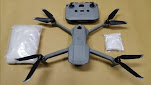
SINGAPORE: Four Singaporeans have been arrested after the authorities seized a drone carrying drugs at Kranji Reservoir Park, said the Singapore Police Force (SPF) and Central Narcotics Bureau (CNB) in a joint news release on Saturday (Jun 20).
According to the release, the police detected "unusual unmanned aircraft activity" in the vicinity of the park at about 5.45pm on Wednesday.
Officers from the Woodlands Police Division were dispatched to investigate and they observed a drone, with a bag attached to it, hovering in the air.
The police subsequently found and arrested two men, aged 29 and 34, believed to be operating the drone. The drone and a black bag attached to it were retrieved.
Investigations showed the bag contained substances suspected to be controlled drugs - about 278g of Ice. CNB officers searched one of the men's car parked in the area and found an assortment of controlled drugs - about 35g of Ice, 8g of heroin and 195 Ecstasy tablets.
"The two men were suspected to have operated the unmanned aircraft from Singapore, to import drugs from Malaysia. The flight data retrieved from one of the suspects' phone showed that the unmanned aircraft had flown from Kranji to Johor Bahru and back again to Kranji that day," the release stated.
Both men were charged on Friday with trafficking Class A controlled drugs.
TWO MORE ARRESTED
A follow-up operation on Jun 18 led to the arrest of another man and a woman. The 24-year-old woman, a suspected drug abuser, was arrested in the vicinity of a private housing estate at Marne Road. The 40-year-old man, a suspected drug abuser, was arrested shortly after in a unit within the housing estate.
As the man "refused to heed the lawful orders of the CNB officers to open the door", forced entry was effected, the release said. A total of about 76g of Ice, a small amount of heroin, two Erimin-5 tablets and cash amounting to S$13,230 were found in the unit.
The total value of the drugs seized in both operations is estimated to be at least S$44,000.
The 389g of Ice seized in total is enough to feed the addiction of about 220 drug abusers for one week, the authorities said.
Investigations are ongoing.
Source: CNA/dv(hs)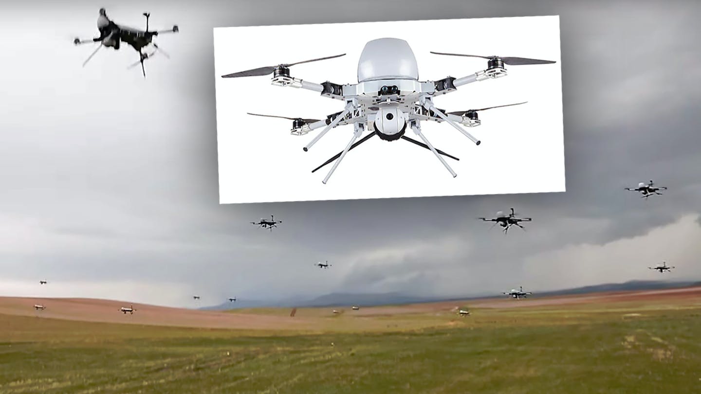
This is yet another wake-up call to the threat that low-end weaponized hobby-like drones pose and how widespread they will become.
The Turkish military reportedly plans to buy more than 500 quad-copter-type Kargu series loitering munitions, or suicide drones, in the near term. The Kargus, at present, can operate in semi-autonomous or manually-controlled modes, but work is underway to give up to 20 of them the ability to carry out mass attacks as a swarm, which could give Turkey's troops a potentially game-changing new capability.
Turkey's state-run Anadolu Agency news outlet first reported that Defense Technologies Engineering and Trade Inc., also known by its Turkish acronym STM, was expecting to deliver the hundreds of drones to the Turkish armed forces on June 15, 2020. It's not clear if this total order for "over 500" of the drones includes or is in addition to a purchase agreement for 356 Kargus that the Turkish government itself announced in January.
STM introduced the first generation Kargu in 2017 and the Turkish military first began receiving small numbers of the improved Kargu-2 variant last year. Turkish forces have reportedly at least deployed, if not employed, the drones during operations along the country's border with Syria last year.
The manufacturer says that Kargu, a name that literally translates as "hawk" in Turkish, and which is also used to refer to small mountain watchtowers, "has been engineered specifically for anti-terror and asymmetric warfare scenarios." The 15-pound Kargu-2 can fly at up to 90 miles per hour and can remain airborne for up to 30 minutes. It has a line-of-sight control link with a range of around six miles.
The Kargu-2 can also fly higher, has a longer range, and has the ability to remain in a designated area for a longer period of time compared to the earlier models. It also has updated targeting capabilities and improvements to reduce its auditory signature, the latter of which helps reduce the chance that an opponent will spot the drone before it's too late.
An operator on the ground can manually control any of the Kargu series drones and use their onboard sensors, which includes electro-optical and infrared video cameras and a laser imaging system, or LIDAR, to conduct general surveillance and identify and track targets. They can then direct the quad-copters to attack a designated threat, even if it's on the move. The loitering munitions can also safely return to their operators for re-use if no targets are found.
The drones can carry one of three different types of warheads, including a high-explosive fragmentation one for engaging personnel and other unarmored targets in the open, a thermobaric type good for targets in confined spaces such as buildings or caves, and a shaped charge for attacking lightly armored threats. Each one weighs around three pounds. The drone's warhead can also be set to function on impact or airburst above the target, the latter being a feature particularly useful for the fragmentation and thermobaric types.

A Kargu-2 drone. Its warhead is seen on top in the center.
The operator can also employ the Kargus as a traditional missile against fixed targets. In this method of attack, the drone would use its GPS navigation system to strike the desired location.
The Kargu series of drones can also operate in a semi-autonomous mode, wherein the operator directs the quad-copter to fly to a certain area and then detect and engage targets on its own. As long as the line-of-sight control link remains unbroke, the operator remains in-the-loop throughout the process and can redirect the drone or abort its attack, if necessary. Israel has long been a pioneer of these kinds of man-in-the-loop control systems, which are now the default for most suicide drones and have become increasingly popular on other types of munitions, as well.
Most importantly, however, last year, STM announced it was working to give the Kargu family of drones additional autonomy and the ability to work together in large swarms. The swarming technology is in development as part of a larger Turkish government program known as Kerkes, which is also looking to develop systems to improve the ability of drones to operate in GPS-denied environments, something that is increasingly a very real threat.
It's not clear how heavily networked together the company is expecting to make the armed quad-copters, but even being able to launch more rudimentary massed attacks with up to 20 of them at a time would offer a significant boost in capability.
Tests have shown that a single Kargu with the air-bursting high-explosive fragmentation warhead can effectively engage clusters of personnel within a circle around 20 feet in diameter. More than one working together could evenly engage threats across a relatively wide area. Beyond just being devastating to concentrations of personnel, this could enable quick large scale attacks against other soft targets, including convoys of light vehicles, parked aircraft, radar dishes and sensor systems, ammunition and fuel dumps, and much more. With a mixture of the different warhead options presently available for Kargu, a group of the drones might be able to carry out more complex attacks, as well.
If the swarming Kargus have the ability to operate in a fully-autonomous mode, within pre-set parameters, they could become even more capable. Swarms by their very nature can confuse and overwhelm an opponent's defenses, even those belonging to major militaries, causing havoc even if a significant number of them get shot down before they can reach their targets. This is a very real threat that War Zone has explored in detail on multiple occasions in the past.
Based on its general size and configuration, the Kargus appear to be a relatively low-cost option for providing this capability, which also underscores how low the barrier to entry for this kind of swarming technology is becoming. Beyond more robust military developments with regards to swarming, small quad-copter-type drones flying in large coordinated formations have been employed in the commercial sector for years now, as well.
The swarming technology STM is developing may also be applicable to other drones and loitering munitions it is developing now. Among its other products, the company also offers a fixed-wing tube-launched loitering munition, called Alpagu, which is very similar in form and function to AeroVironment's Switchblade and is now also in Turkish service.
It seems very possible that, in addition to providing these improved Kargus to the Turkish armed forces, STM could also seek to export them, proliferating this capability further around the world. STM has already said that it has received serious inquires about the Kargu series from at least three unnamed potential foreign customers. Turkey, as a whole, has become a powerhouse of drone development and production, employing larger types to great effect in Syria and Libya just this year.
This is precisely the type of weapon we have been warning about for years now. The fact that it is already here and potentially exportable should be yet another wake-up call to the level of threat low-end drones pose to U.S. and allied forces, as well as domestic infrastructure and VIPs.
"I argue all the time with my Air Force friends that the future of flight is vertical and it's unmanned," U.S. Marine General Kenneth McKenzie, head of U.S. Central Command, said at an event hosted by the Middle East Institute last week. "I'm not talking about large unmanned platforms, which are the size of a conventional fighter jet that we can see and deal with, as we would any other platform."
"I'm talking about the one you can go out and buy at Costco right now in the United States for a thousand dollars, four quad, rotorcraft or something like that that can be launched and flown," he continued. "And with very simple modifications, it can make made into something that can drop a weapon like a hand grenade or something else."
The Kargus, and their future swarming capabilities, could very well become the next major Turkish drone success story, for better or worse.
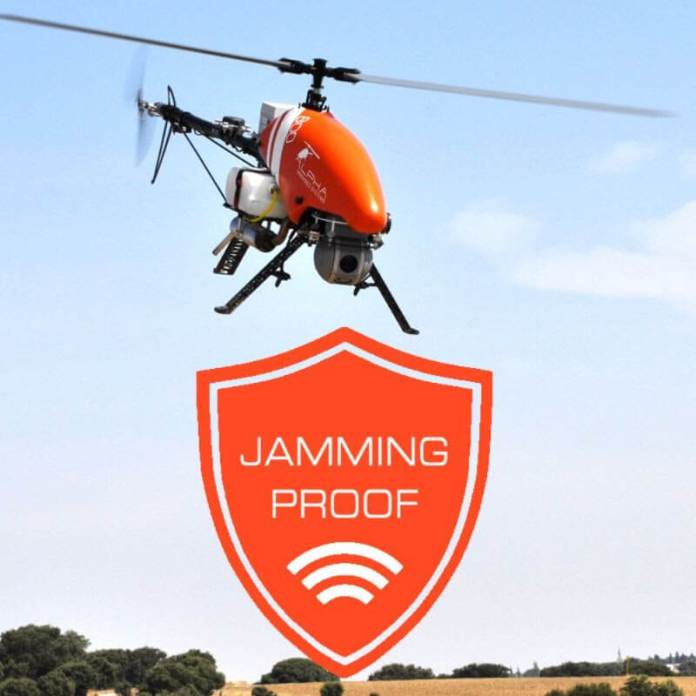
Meaconing, Intrusion, jamming, and Interference are of primary importance when it comes to UAV operations. MIJI refers to the interception and rebroadcast of signals that are more powerful than those used to navigate an aircraft. Although attacks of this nature are possible on any type of signal, the GNSS is the most affected.
The UAV Helicopter Alpha 800 equipped with the UAV Navigation Autopilot rejects interference from a range of anti-drone jamming guns, and continues operating with no major issues.
Interception is resisted due to the non-dependence of GNSS for critical system loops, allowing for continued operation without multiple cross supervisory logics. When jammed, the Alpha 800 will continue flying without GNSS, escaping the jamming range to enable GPS and finish its mission.
By PRESS
Latvian drone startup Aerones has announced a $1.6 million seed investment and a whole new direction for the business: the funding will go toward a ground-based robotics system for wind turbine maintenance and inspection. The round was backed by Change Ventures, YCombinator and the Sensum Group, as well as angels Paul Buchheit and Janis Krums.
The new ground-based system is based on a patented technology, wherein a computerised winch allows a robotic arm to perform many tasks, such as close-up photography, laser scanning, lightning conductivity tests, blade cleaning, and coating protective materials.
“Technicians who would otherwise hang hundreds of meters in the air manually working on each turbine blade, where safety concerns and weather limit operations, can now operate these inspection and maintenance services from the safety of a van, with controls that are as easy to use as a kid’s gaming console,” says Janis Putrams, the startup’s CEO.
Based in Riga, the Baltic business previously developed heavy-lift industrial drones, participating in YCombinator W18, finishing in the top three of Slush’s 100 Pitch Competition in 2018, and securing €2.7 million in funding just last August.
“In Aerones we see a company that has spent the last two years understanding in detail the challenges faced by the wind energy industry,” says Andris K. Berzins, managing partner of Change Ventures. “Using these insights, they re-invented their initial drone technology to tailor a robot & winch system that is so elegant that it will take the industry by storm.”
Some Aerones robots are already deployed in the US and Europe after completing successful pilots last year. The fresh funding will help increase commercial adoption and expand the company into the US
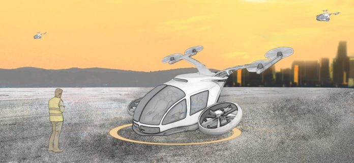
The growth of the Air-taxi and eVTOL industry in the last decade and the deep study of its potential has originated a wide diversity of aircraft, demanding the existence of different regulations to correctly cover the appropriate security requirements in each case.
This is the case of VTOL aircraft, whose characteristic is vertical takeoff and landing. These manned drones have specific characteristics that make it complicated to cover its functionalities with the existing certification specifications for aircrafts such as fixed-wing or gyroplanes (i.e. CS-23). The VTOLs differ from fixed-wing aircraft in vertical takeoff and landing capability. And from conventional gyroplanes in the distributed use of propulsion. For this reason, specific regulations are required for VTOL type certifications.
AESA SPECIAL CONDITIONS FOR VTOL
After detecting this need, the European Aviation Safety Agency (EASA) published on July 9, 2019 a regulation with a complete set of technical specifications dedicated to VTOLs, SC-VTOL-01. These specifications apply to certifications for aircraft with people transport (9 or less), takeoff and vertical landing with several propulsion units used for lifting and control, whose takeoff weight is less than 3175Kg, including most of the eVTOL system for UAM (Urban Air Mobility).
CERTIFICATION CATEGORIES
The regulations establish two categories of certification:
- The “Basic” category in which it is ensured that the aircraft is capable of making a controlled emergency landing.
- The “Enhanced” category, more restrictive than the previous one, which guarantees a safe flight mode for emergencies, also including landing. The aircrafts dedicated to operating over populated areas or commercial passenger transport must be certified in this category.

AUTOPILOT REQUIREMENTS FOR EVTOL CERTIFICATION
The autopilot system within the eVTOL is, in most cases, a critical component as it may lead to a catastrophic failure in case of a flight controller malfunction. For this reason, it must attend to the highest safety levels required by the Standard Condition for VTOL. It means that for Enhanced Category the autopilot must prove a failure rate below 10-9 and FDAL A, considering the Design Assurance Level for Aircraft Functions. Being this the maximum applicable safety requirement, each eVTOL may have different requirements according to system architecture and safety means included.
The certification regulations are the passport that this new type of aircraft needs to enter into the Urban Air Transport market, ensuring the viability and safety of their coexistence in current society. There are many advantages that lead us to work to make this possible. At Embention, we are carrying out different projects with this objective, developing our products based on current regulations to reaffirm the reliability of these systems for the new generation of people transport.
By PRESS