Site blog
The following is a summary of the newly updated regulations. Please note that these Regulations do not come into effect until June 1 2019
You will require an SFOC up until June 1 2019
Single weight class from 250g -25kg for VLOS operations
Single set of regulations for recreational and commercial use, does not matter if you use your drone for fun or for work
The updated Canadian Gazette 2 document is here for download
The Knowledge Requirements for drone pilots is here for download.
Operations fall into two type of operations
- Basic - Uncontrolled airspace (Usually away from cities and towns, out in the country)
- Advanced - Controlled airspace (Usually found where ever there is an airport, or hospital heli pad)
We offer an online course that will help you pass either of these Transport Canada exams
Advanced Knowledge Requirements for Pilots of RPAS 250g up to 25 kg VLOS
Basic Operations and Basic Pilot Permit
- Class G airspace only (uncontrolled airspace)
- 1 nautical mile from heliports, 3 nautical miles from airports
- Aircraft must be registered and marked with registration number from Transport Canada
- Basic online Transport Canada test passed
- Minimum 14 years old or adult supervised
- Operations within built-up areas permitted
- No operations over people, must be minimum 30M distance from anyone
- Maximum altitude 400 feet
- Night operations permitted
- Must be flown within Visual Line of Sight (VLOS)
- No liability insurance required
Advanced Operations and Advanced Pilot Permit
- Class G, C-F airspace (controlled airspace)
- Operations near airports with Air Traffic Control (ATC) approval
- Manufacturers must declare their drone has a Safety Assurance (This can be found when you log into your Transport Canada online drone portal account and register your drone. The site will tell you if your specific drone is Safe Assured and wether it can be used in Controlled Airpsace)
- Aircraft must be registered and marked with registration number from Transport Canada
- Advanced online very comprehensive Transport Canada test must be passed
- Flight Review must be taken and passed
- Minimum 16 years old
- Operations within built-up areas permitted
- Operations over people with proper safety protocols in place with Safe Assured drone, 0-30M from people
- Maximum altitude 400 feet
- Night operations permitted
- Must be flown within Visual Line of Sight (VLOS)
- No liability insurance required
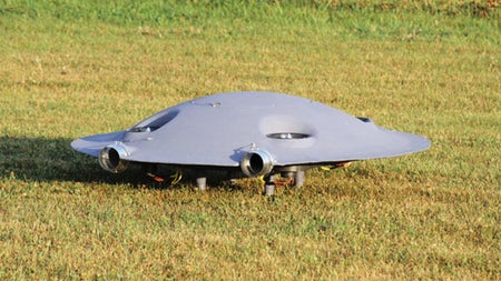
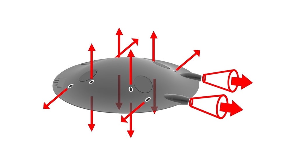
At low speed, it operates like a quadcopter, at high speed, it's a jet-propelled, highly efficient supersonic aircraft whose entire body acts as a low-drag wing. Those are the claims of the Romanian creators of this flying saucer that's designed to offer unprecedented aerial agility across a broad range of speeds.
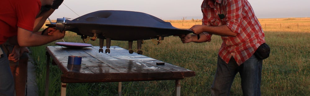
ADIFO, or the All-DIrectional Flying Object, is a flying machine designed "to change the actual paradigm of flight," according to engineer and inventor Razvan Sabie. Sabie worked with accomplished aerodynamicist Iosif Taposu (Senior Scientist at Romania's National Institute for Aerospatial Research, and former Head of Theoretical Aerodynamics at the National Aviation Institute) to develop the concept, and has built a working prototype with a 1.2-meter (3.9-ft) diameter for testing.
Simply put, ADIFO is a disc-shaped aircraft whose entire surface is a wing. Specifically, it's shaped to mimic the back half of a dolphin airfoil, radiating out in all directions from the center. The outer edge tapers to a thin ring, making it extremely slippery in horizontal flight.
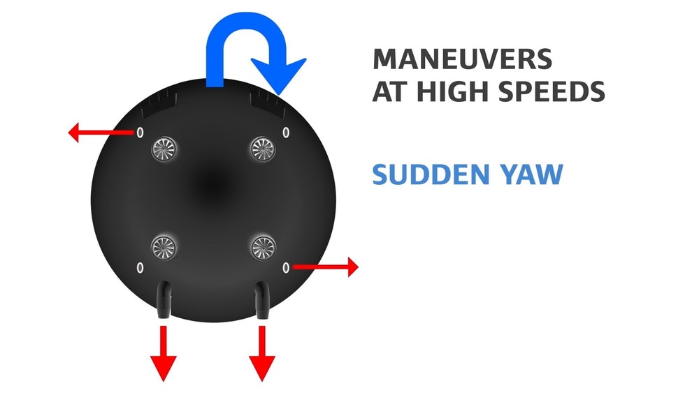
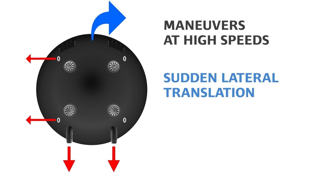
VTOL and slow speed maneuvers are handled by four ducted fans, letting the ADIFO operate like a regular quadcopter drone. There are also two jets on the back (replaced by additional electric fans on the prototype) that provide horizontal thrust, and which can also vector individually to achieve a high degree of agility in level flight. At high speeds, small discs can come out and cover over the quadcopter fans for an even smoother profile, and likewise the legs can retract.
The final propulsive touch is a set of two lateral thrust nozzles pointed out to each side, which operate like the reaction control system thrusters on a spacecraft. In horizontal flight, these allow the ADIFO to rapidly push itself sideways in either direction, or to rotate extremely quickly as it flies. That, according to Sabie, gives it maneuvering capabilities unmatched by anything else in the air, without the need for separate wings, ailerons, rudders or flaps.
There's more: it'll fly upside down, either in quad mode or in horizontal flight, with the right jets it'll be extremely efficient as it goes transonic and supersonic, and Sabie says the team's modeling suggests there will be no traditional sonic boom created when it does.
While the prototype is obviously unmanned and radio controlled, the ADIFO team claims it has the potential to democratize supersonic flight if it gets built into a single or multi-seat manned aircraft with a hybrid electric/jet propulsion system. It'll be interesting to see how the team builds pilot visibility into the mix, and what sort of control scheme you'll need to handle the flying saucer's variety of flight modes and control options.
It's a fascinating idea, and could clearly offer some mind-bending acrobatic flight capabilities once the wrinkles are ironed out. There's certainly nothing else out there that can hover and dart about like a drone, while also offering extreme high-speed performance as well as the ability to spin wildly or suddenly produce thrust in five different directions at speed – not to mention potentially employing the main ducted fans to tilt or even flip the aircraft in horizontal flight. The mind boggles just thinking about what this could do in the hands of a well-trained pilot – as well as how treacherous it could be for the ham-fisted.
At the same time, it doesn't seem like a ludicrously far-fetched thing to get built. There are plenty of manned electric multirotors in development, with more or less the same kinds of capabilities ADIFO promises in low-speed flight. Those things are happening, nobody is in any doubt. The vectored thrusters on the back end are far from new, jet propulsion is more common and reliable than ever, and there's nothing about the tapered body shape that looks impossible or even super difficult to build. ADIFO might need to consider additional ducted fans, or contra-rotating coaxial props, for redundancy, but it certainly doesn't look impossible.
Sabie and Taposu are looking for partners to take ADIFO into the next stages of development. Check the aircraft out in the video below.
Source: ADIFO Aircraft

By Mike Koshmrl Jackson Hole News&Guide Via Wyoming News Exchange JACKSON — A California-based drone manufacturer is being investigated for promoting its “true follow-me” technology with footage of a Rollerblader kicking it along a West Thumb Geyser Basin boardwalk.
Flying drones is illegal in Yellowstone and all other national parks, as is in-line skating on boardwalks. The drone company involved, named Skydio, geo-tagged the Wyoming video as shot in Iceland.
“Thermal tour a la rollerblade,” the company posted in a caption alongside the video, which was viewed over 10,000 times in its one week up on Instagram.
The video has since been removed.
Skydio representatives initially responded to the News&Guide’s request for an interview over email, but their willingness to talk withered when the story’s topic was disclosed.
Based in the Bay Area, Skydio pitches itself as a startup created by former Google engineers that got off the ground with $28 million in venture capital raised through the fall of 2017.
The “pre-eminent investors” the company lists on its website include Justin Timberlake and Magic Johnson.
Yellowstone National Park law enforcement rangers learned of the video’s existence last week and, as of Tuesday morning, had not made any determinations, park spokeswoman Morgan Warthin said.
“They are aware, and they will investigate it,” Warthin said. “What’s important to recognize is that there are so many incidents of drone use that we deal with. Visitors using drones in Yellowstone is a problem.”
During 2018 there were about 40 drone flights that Yellowstone rangers became aware of. A chunk of those resulted in citations, some of which resulted in mandatory court appearances for pilots, who paid over $1,000 to square up on fines, Warthin said.
The Greater Yellowstone Ecosystem’s two national parks have been home to a number of infamous illegal drone flights since the National Park Service banned the emerging technology from its 419 properties in 2014. The Park Service director at the time, Jon Jarvis, said the policy was necessary because drones were interfering with rescues, causing excessive noise, ruining views and disturbing wildlife.
Perhaps the most notorious illegal Yellowstone drone took flight five years ago. The aircraft never made it back to its owner, Dutch tourist Theodorus Van Vliet, who crashed his drone into Grand Prismatic Spring and was fined more than $3,000. His DJI Phantom quad-copter was never recovered, and its remnants stew today in Grand Prismatic’s depths. Scientists have worried that the sunken drone could clog one of Grand Prismatic’s vents or melt and forever alter the microbial mats that make the famously photographed spring so brilliant.
In Jackson Hole a drone in 2017 illegally buzzed world-famous grizzly bear No. 399, who eyewitnesses said wasn’t too bothered. But earlier that year some 1,500 elk gathered on the National Elk Refuge had the opposite response, stampeding a half-mile away from Highway 89 toward Miller Butte after a Washington, D.C., man’s drone spooked them.
Problems with drone use in Grand Teton National Park have persisted, too. All told there have been 45 drone flights since 2015 that resulted in a citation or warning from a Teton park ranger, spokeswoman Denise Germann said.
Though the West Thumb rollerblading scene Skydio shared on Instagram drew oohs and ahs from most followers who weighed in on the social media site, some weren’t too enamored.
When Instagram user @matdifference inquired on a comment thread where in Iceland the footage was shot, fellow Instagrammer @javier.g.roeth set the record straight.
“It’s not Iceland,” he wrote. “It’s Yellowstone National Park, and it’s illegal to fly drones in national parks. Shady and irresponsible marketing!”
Social media’s faithful mob mentality quickly took over, and other commenters piled on.
“Super dishonest,” Instagrammer user and avid drone photographer @justin_mcvideo posted.
“I was following this account, but no more. Shame.”
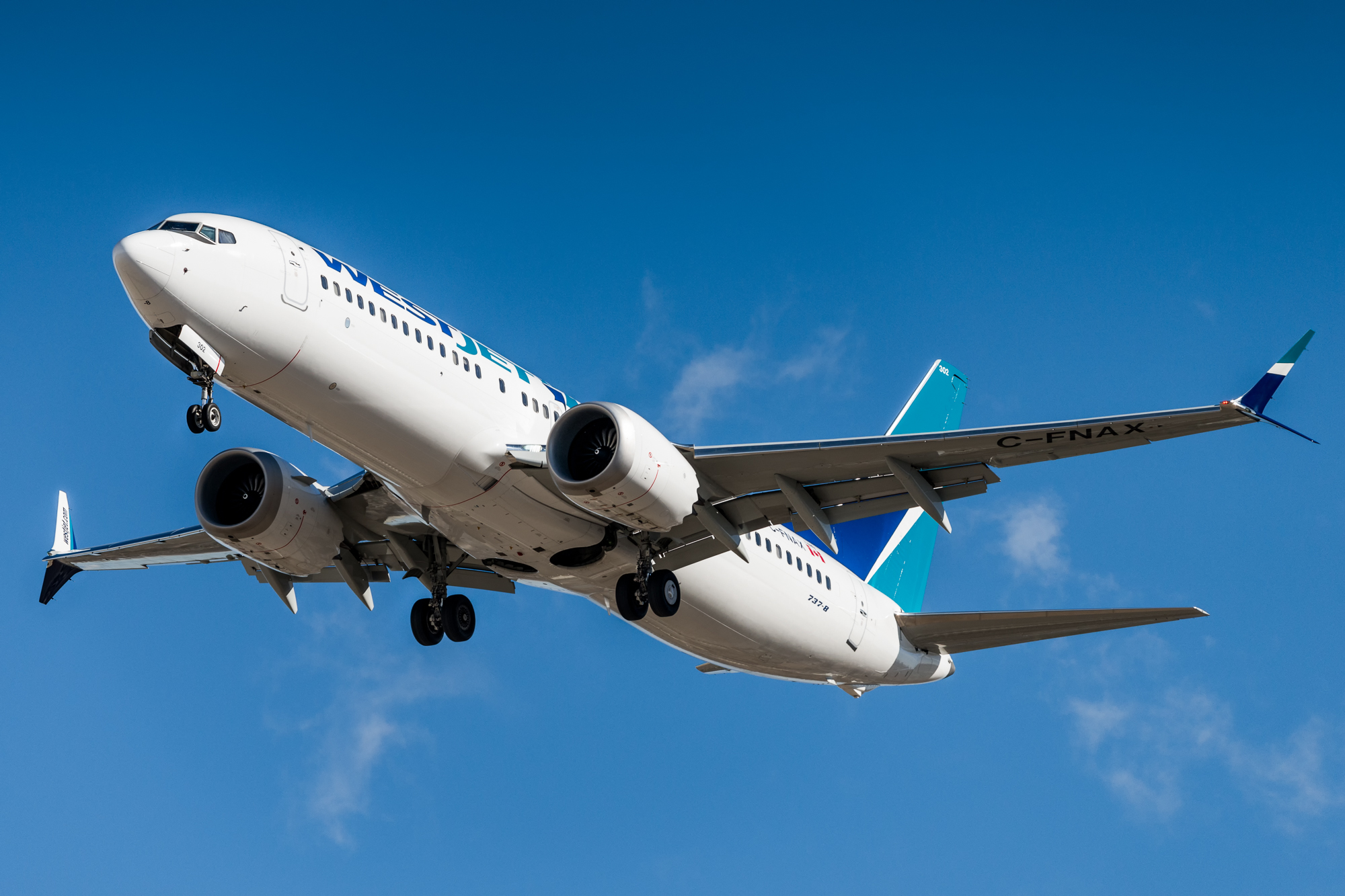
By Alan Levin . The first concrete evidence of a possible link between two deadly Boeing 737 Max crashes came from space. A new satellite network capable of tracking planes in high fidelity across the globe captured the flight path of the Boeing Co. 737 Max that crashed Sunday. The data was critical in persuading the U.S. to join the rest of the world in grounding the jet, according to industry and regulatory officials.
The erratic, six-minute flight of the Ethiopian Airlines plane convinced the Federal Aviation Administration that it was close enough to what preceded the Oct. 29 crash of another Max off the coast of Indonesia to warrant concern.
After reviewing the data “it became clear -- to all parties, actually -- that the track of the Ethiopian Airlines flight was very close and behaved very similarly to the Lion Air flight,” agency Acting Administrator Daniel Elwell said Wednesday.
Canada’s Transport Minister Marc Garneau also cited satellite tracking on Wednesday as the reason his country joined more than 50 other nations in grounding the 737 Max models.
The data was provided by Aireon LLC, which was formed in 2012 by Iridium Communications Inc. and Nav Canada, a nonprofit company that guides air traffic in Canada. After years of development and the launches of 66 satellites into orbit, Aireon will introduce a new commercial flight-tracking service in coming weeks.
The company shared the information with the U.S. National Transportation Safety Board and Federal Aviation Administration, as well as “several European aviation authorities and various African aviation authorities,” said Jessie Hillenbrand, an Aireon spokeswoman.
Elwell said that initial tracks of the plane available immediately after the accident by a separate company with a ground station in Ethiopia weren’t consistent with how aircraft fly and weren’t credible. However, when agency experts reviewed a refined track provided by Aireon, it raised concerns.
The Lion Air plane experienced more than two dozen sharp dips shortly after takeoff. Indonesian investigators said in a preliminary report that the plane was automatically commanded to dive because software known as Maneuvering Characteristics Augmentation System, or MCAS, thought the plane was in danger of losing lift on the wings.
Aerodynamic Stall
Boeing had added the MCAS as protection against an aerodynamic stall. However, in the case of the Lion Air flight, a malfunctioning sensor signaled that the plane was in danger when it wasn’t and it commanded unnecessary dives.
Rather than switching off the motor triggering the dives -- a procedure pilots on all models of the 737 are taught to memorize -- the Lion Air crew continued counteracting it with their controls until it dove into the sea.
While Elwell and Canada’s Garneau didn’t detail the Ethiopian plane’s flight path, it apparently made the same highly unusual descents followed by climbs. Normally, a jet climbs steadily after takeoff.
“It certainly puts a magnifying glass on the MCAS system,” said Peter Goelz, a former managing director at the NTSB who is now senior vice president at O’Neill & Associates, a Washington lobbying and public relations firm. “There’s an implication that there were two similar accidents and that it likely involved the interaction of the MCAS system with the flight of the aircraft.”
Kevin Durkin, an aviation lawyer, said the connection could be important in any court cases. If Boeing knew of a defect in the 737 Max fleet, the plane manufacturer could face extra damages in lawsuits. The company’s knowledge might be demonstrated by its statements that it was making software changes after the Lion Air crash, he said.
“If you have a defective product and it turns out Boeing knew about it, this could easily expose them to punitive damages,” said Durkin, a partner at Clifford Law Offices in Chicago. The standard is whether the company engaged in conduct with a “conscious indifference to the safety of others,” he said.
Boeing has said that following longstanding procedures should prevent accidents involving MCAS failures.
On Wednesday, the Chicago-based manufacturer issued a statement saying it still has “full confidence” in the plane.
“We are supporting this proactive step out of an abundance of caution,” Boeing Chief Executive Dennis Muilenburg said in the statement, referring to the FAA action. “We are doing everything we can to understand the cause of the accidents in partnership with the investigators, deploy safety enhancements and help ensure this does not happen again.”
Elwell cautioned that there is still no definitive evidence suggesting that the two accidents are related.
The Indonesian accident investigation isn’t complete. In addition to MCAS, the preliminary report cited repeated maintenance failures and pilot performance issues. For example, the Lion Air plane suffered the same MCAS malfunction on a previous flight but it wasn’t repaired.
The Ethiopian pilots had received notice about MCAS and additional training suggested by Boeing after the Lion Air accident, Tewolde Gebre Mariam, chief executive of Ethiopian Airlines told reporters in a broadcast on state-controlled ETV.
The tracking of aircraft from space was made possible by technology designed to move away from traditional radar tracking as the U.S., Europe and other regions introduce more modern technology to their air-traffic systems. By the end of 2020, most aircraft in the U.S. will have to be equipped with devices that use GPS to calculate a plane’s position and then broadcast that and other information about the flight.
The U.S. invested more than $1 billion in building a network of ground stations that track the signals as it attempts to move to the tracking technology, known as Automatic Dependent Surveillance-Broadcast or ADS-B. That network is operated by Harris Corp., which is also a partner with Aireon.
The same data transmissions reach space only a small fraction of a second after the ground antennas and it’s what Aireon relied on to track the Ethiopian Airlines flight. A ground station operated by tracking firm FlightRadar24 captured only data from the first two minutes of the flight before the plane went out of range.
Aireon has agreements to sell its data to countries including Canada and the U.K. to track flights over the ocean, where ground-based radar doesn’t reach and planes must be kept far apart.
In addition to helping air-traffic agencies monitor flights over oceans and in countries without radar, Aireon has said the data may also assist accident investigations and help locate aircraft that crash in remote areas.
It took about two years to find an Air France plane that went down in the Atlantic in 2009, but Aireon’s data would have limited the search area to a mile or less.
“We now have a global picture of all aircraft,” Don Thoma, Aireon’s chief executive officer, said in an interview last month. “It’s finally real. It’s finally here.”
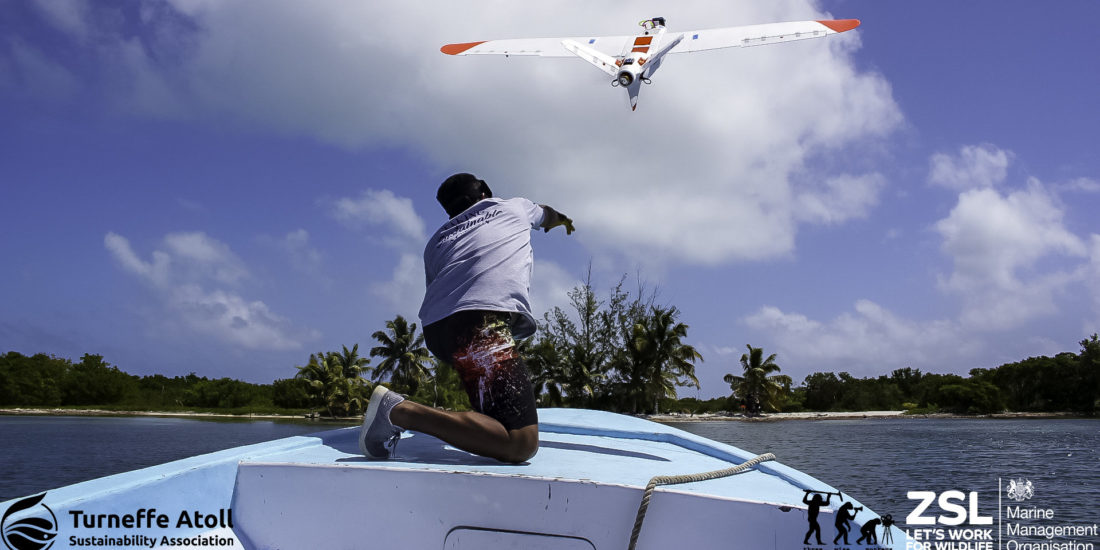
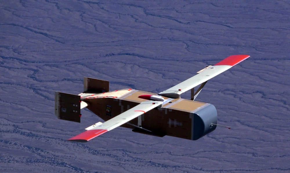
The Aeromapper Talon Amphibious is the only truly affordable fixed wing UAV system that can be used for inspection and mapping in marine environments. The UAV system delivers high resolution georeferenced imagery as well as video feed from up to 30 kms from the operators. After completing its mission the UAV later returns and safely lands on the water, adequately serving maritime Beyond Visual Line of Sight (BVLOS) operations.
But how to ensure proper waterproofing for repeated landings on the water?
By design, the UAV can stay indefinitely afloat on the water, and even sustain full immersion without any damage or water intrusion, even in salt water.
To reach this level of dependability the engineers at Aeromao spent more than a year of lab work and field testing, experimenting with different materials, solutions & compounds, techniques and components to ensure a very high level of reliability. The base model is the well-known Aeromapper Talon, which has been the flagship for the company since 2014. The UAV is designed to fully survive and float even if fully filled with water, because internal components have been carefully waterproofed individually.
Some of the industries that can benefit from this technology are:
- Coastal & river mapping/surveying
- Fisheries
- Inspection of infrastructure or wildlife
- Ecology & conservation
- Surveillance
- Marine management
Flying on remote atolls
As of this writing, a couple of Amphibious Talon units have been successfully operating during a 4 week expedition by a worldwide renowned British conservation institution. The location is on an undisclosed remote atoll in Belize, as part of a series of very important efforts for conservation & ecology and enforcement and control of illegal fishing activities over protected areas.
The type of terrain offers little or no land to operate from, therefore only truly amphibious drones are usable. The drones have been successfully launched from both beaches or small boats and then landed autonomously landed on the water after each flight is completed.
The expedition team required a drone capable of be launched from a boat, record high resolution video and stills, send live video feed to the Ground Station at very long ranges, be able to fly in 40km/h winds, return and land on water, and repeat several times daily and for several weeks. The Aeromapper Talon demonstrated to be the only suitable solution for the challenge. More information on the expedition to come soon.
More information about the Aeromapper Talon Amphibious can be found here:
https://www.aeromao.com/aeromapper_talon_uav/aeromapper-talon-amphibious/
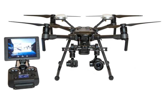
By Press . The CAA has received six Mandatory Occurrence Reports in the last three months affecting the DJI Matrice 210 series drone. The reports have indicated that on each occasion the DJI M210 has malfunctioned resulting in uncontrolled descent and consequent damage to the airframe upon impact with the ground. Reports suggest the issue may lie with one of the airframe’s motors. We are working with the manufacturer and monitoring the situation.
All users of the DJI M210 series are advised to consider their obligations under Art. 241 of the ANO and avoid flying over people or property until further notice.
Drone technology is being developed with the aim of making logistics supply chain in war zones more efficient. Aviation Week & Space Technology reports that the wooden aircraft the LG-1K developed by Logistic Gliders Inc under contract with DARPA and the U.S. Marine Corps War-fighting Laboratory is undergoing trials in the California skies.
With the aim to meet the requirements of being inexpensive and expendable the LG-1K drone is made from plywood and aluminium and is designed to be released from fixed-wing aircraft or helicopter. It is made up of plywood and aluminium, is 10.4 feet long and has a 23 foot wingspan. The LG-1K has the capacity of carrying up to 700 lbs. of supplies. LG-1K has already flown twelve missions demonstrating its ability to glide—in some cases autonomously to a landing zone with GPS precision.

The functioning mechanism involves the drone either being pushed out the back of an aircraft or being released from a sling load. Initially its wings are folded back during transport but they pop out once the drone is airborne. The LG-1K can fly at speeds of up to 135 knots. For ease of navigation around rough terrain it can also be programmed to fly to specific waypoints. On approach to the target, it pops a parachute at 200 feet and comes in for a landing.

The gliding feature itself is extremely low-tech however; the drone incorporates electronics and control systems that allow it to fly by remote control or autonomously to a set of pre-programmed GPS coordinates.
The company expects the drone to be compatible with MV-22 and CV-22 Osprey tilt rotor aircraft, KC-130, C-130, and C-17 transports, and MH-60, UH-60, CH-53, and CH-47 helicopters. In fact the MV-22 Osprey could carry up to three of the drones, and as per Aviation Week & Space Technology a C-130 could carry as many as 18, potentially resupplying many units with a single fly over sortie.
The drone could prove to be very helpful in terms of providing support to ground troops in wars such as Afghanistan and against the Islamic State, by delivering supplies to friendly columns patrolling miles from a forward operating base for instance. It would also prove useful to the US forces against near-peer threats such as those from Russian or Chinese advanced air defences. In a scenario where ground forces, particularly those operating on small islands, finding themselves close enough to the enemy to be cut off by air, for example, a resupply aircraft could fly right up to the edge of enemy air defences and release supply drones that could fly the rest of the way on their own without placing human beings at risk. Aviation Week & Space Technology reports that Logistics Gliders anticipates the cost of each drone could be from $4,500 to $11,000 roughly.
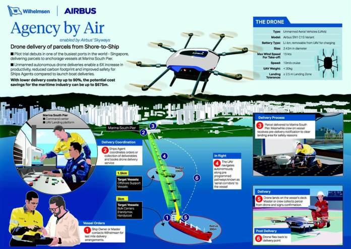
By Press. Singapore, Airbus has begun shore-to-ship trials in Singapore with its Skyways parcel delivery drone. This marks the first time drone technology has been deployed in real port conditions, to deliver a variety of small, time-critical maritime essentials to working vessels at anchorage.
The maiden shore-to-ship delivery flight was made to the Swire Pacific Offshore’s Anchor Handling Tug Supply vessel ‘M/V Pacific Centurion’, 1.5km from the shoreline of Singapore’s Marina South Pier, carrying 1.5kg of 3D printed consumables. Landing safely on the ship deck and depositing its cargo to the shipmaster, the Skyways unmanned air vehicle swiftly returned to its base, with the entire flight taking within ten minutes.
The trials are being undertaken in conjunction with partner Wilhelmsen Ships Services, one of the world’s leading maritime logistics and port services company. During the trials, Airbus’ Skyways drone will lift off from the pier with a payload capability of up to 4kg, and navigate autonomously along pre-determined ‘aerial corridors’ to vessels as far as 3km from the coast.
Airbus’ Skyways lead, Leo Jeoh shared his excitement at the milestone flight: “We are thrilled to launch the first trial of its kind in the maritime world. Today’s accomplishment is a culmination of months of intense preparation by our dedicated team, and the strong collaboration with our partner, as we pursue a new terrain in the maritime industry.”
“We are also happy to be taking a step forward for Airbus’ urban air mobility endeavour, as we continue to explore and seek better understanding of what it takes to fly safe and reliable autonomous flying vehicles safely,” he added.
“The now proven, seamless operation of drone deliveries from shore to ship, in one of the world’s busiest ports proves the hard work, investment and faith we, and indeed our partners, placed in the Agency by Air project over the past two years was not misplaced,” said Marius Johansen, Vice President Commercial, Ships Agency at Wilhelmsen Ships Services.
Airbus’s Skyways drone
“Delivery of essential spares, medical supplies and cash to master via launch boat, is an established part of our portfolio of husbandry services, which we provide day in and day out, in ports all over the world. Modern technology such as the unmanned aircraft systems, are just a new tool, albeit a very cool one, with which we can push our industry ever forward and improve how we serve our customers,” he added.
The use of unmanned aircraft systems in the maritime industry paves the way for possible enlargement of existing ship agency services’ portfolio, speeding up deliveries by up to six times, lowering delivery costs by up to 90%, reducing carbon footprint, and significantly mitigating risks of accidents associated with launch-boat deliveries.
Airbus and Wilhelmsen Ships Services signed an agreement in June 2018 to drive the development of an end-to-end unmanned aircraft system for safe shore-to-ship deliveries. The collaboration marries Airbus’ extensive expertise in aeronautical vertical lift solutions and Wilhelmsen’s wealth of experience in ship agency services. A landing platform and control centre were set up at the Marina South Pier in November 2018, through the facilitation of the Maritime and Port Authority of Singapore. The maritime agency also designated anchorages for vessels to anchor off the pier for the trials, while the Civil Aviation Authority of Singapore worked with Airbus and Wilhelmsen to ensure safety of the trials.
Skyways is an experimental project aimed at establishing seamless multi-modal transportation networks in smart cities. Through Skyways, Airbus aims to develop an unmanned airborne infrastructure solution and address the sustainability and efficiency of unmanned aircraft in large urban and maritime environments.
Having demonstrated the ability to deliver parcels safely and reliably to vessels anchored off the coast of Singapore, Skyways will soon be commencing another trial phase delivering air parcels autonomously in an urban environment, at the National University of Singapore.
About Airbus
Airbus is a global leader in aeronautics, space and related services. In 2018 it generated revenues of €64 and employed a workforce of around 134,000. Airbus offers the most comprehensive range of passenger airliners.
Airbus is also a European leader providing tanker, combat, transport and mission aircraft, as well as one of the world’s leading space companies. In helicopters, Airbus provides the most efficient civil and military rotorcraft solutions worldwide.