Site blog
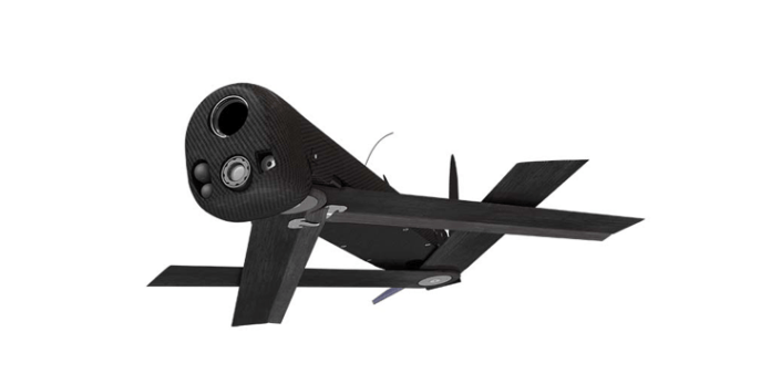
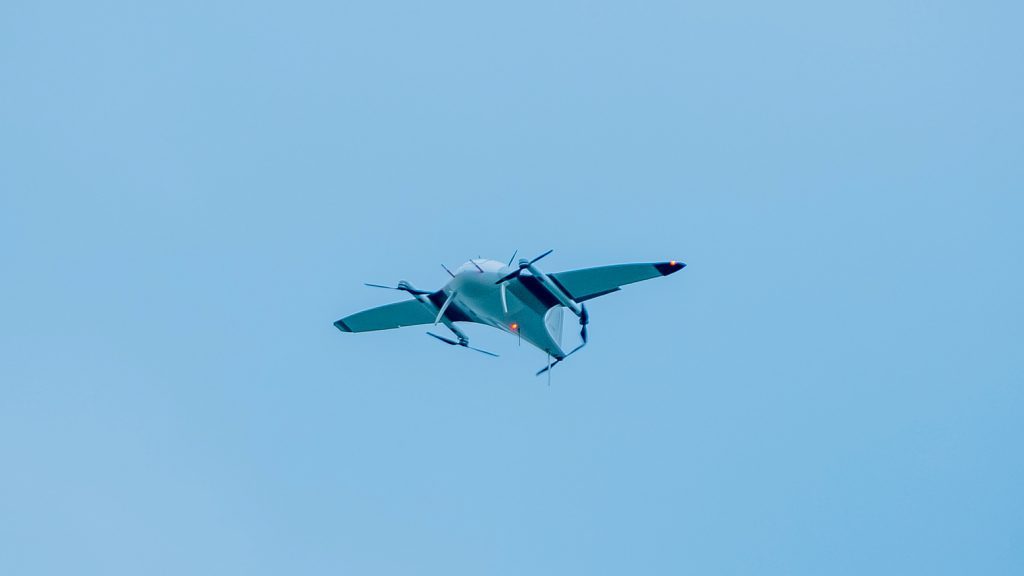
AeroVironment, Inc. (NASDAQ: AVAV), a global leader in unmanned aircraft systems (UAS), announced the receipt of a one-year, $75,930,901 funded contract award on April 30, 2020 from the United States Army for procurement of the company’s Switchblade® loitering missile system. The contract award was funded for the first year of procurement through a Joint Urgent Operational Need Statement from the United States Army Tactical Aviation and Ground Munitions (TAGM) project office. Start of deliveries is anticipated by September 2020. Two additional one-year options, currently unfunded, would extend the period of performance through April 2023 on a sole-source basis.
“For nearly a decade, AeroVironment’s Switchblade has delivered unmatched force protection and precision strike capabilities at the battlefield edge to the U.S. Army,” said Brett Hush, AeroVironment senior product line general manager of Tactical Missile Systems. “We will continue to enhance the capabilities of this battle-proven product, and stand ready with a proven supply chain and customer support system in order to respond effectively to U.S. and allied customers’ needs.”
AeroVironment’s combat proven Switchblade is back-packable and rapidly deployable from ground platforms including a 6-pack launcher, providing warfighters with rapid-response force protection and precision strike capabilities up to 10 kilometers (6 miles) from its launch location. Its high precision, combined with specialized effects and patented wave-off feature, results in Switchblade’s ability to minimize or even eliminate collateral damage.
Northrop Grumman is a key partner on the Switchblade system, providing single purpose and multimode warheads for the program.
Learn more about Switchblade at the AeroVironment, Industry Showcase at vSOFIC https://www.sofic.org/vsofic or at www.avinc.com/switchblade.
About AeroVironment Tactical Missile Systems
Switchblade® and Blackwing™ form the basis of AeroVironment’s emerging family of Tactical Missile Systems. Switchblade is a back-packable, rapidly deployable, precision strike loitering missile for beyond line-of-sight targets that minimizes collateral damage and can be tube-launched from land, sea or air platforms. Blackwing is a variant of Switchblade, designed to provide rapid-response intelligence, surveillance and reconnaissance capabilities and can be launched from surface vessels, submerged submarines and unmanned underwater vehicles. Switchblade and Blackwing are compatible with AeroVironment’s Multipack Launcher (MPL), an all-weather remotely operated launch battery that can be integrated into land, shipboard or mobile operations.
About AeroVironment, Inc.
AeroVironment (NASDAQ: AVAV) provides customers with more actionable intelligence so they can proceed with certainty. Based in California, AeroVironment is a global leader in unmanned aircraft systems and tactical missile systems, and serves defense, government, and commercial customers. For more information visit www.avinc.com
By PRESS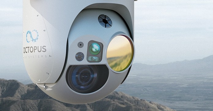
Octopus ISR Systems announced today that it has released the Epsilon 180, a more technologically advanced Full HD electro-optical, Mid-wave infrared, Laser Range Finder and Laser Pointer (EO/MWIR/LRF/LP) ISR payload providing exceptional daylight imaging, improved MWIR performance and extended LRF range.
The newly launched imaging technology includes a Full HD 30x optical zoom, global shutter EO sensor, a state-of-the-art 15x optical zoom MWIR sensor, laser range finder with up to 20km measuring range, and a laser pointer, making this airborne surveillance camera system an ideal choice for unmanned aerial vehicles (UAV) and small manned aviation platforms used for border control, military purposes, and a variety of civil applications.
The multi-mission Epsilon 180 surveillance system features the most powerful onboard processor in its class, with a variety of software features including software image stabilization in three axes, automatic target tracking, and moving target indicator.
The Epsilon 180 offers superior image quality with outstanding image stabilization performance of less than <50 uRad RMS. The ISR payload also integrates high-performance Inertial Navigation System (INS), a high-precision, fully-integrated solution for geopointing and real-time target geolocation.
The Epsilon 180’s rugged and lightweight design is optimized for demanding applications. The system features a sealed structure filled with dry gas, enabling it to operate in any weather conditions. The Epsilon 180’s advanced magnesium structure without any 3D parts is optimized to handle harsh conditions including shock and rapid acceleration.
The payload can be installed in either nose- or belly-mounted positions, offering installation design flexibility for the integrators.
The new Epsilon 180 is available for purchase today.
To learn more, please visit www.octopus-isr.com
About Octopus ISR Systems
Octopus ISR Systems is a trustworthy, well-known brand from UAV Factory, specializing in the design and manufacture of cutting-edge non-ITAR surveillance solutions for both the manned and unmanned industries. Octopus ISR Systems offers airborne surveillance systems of the highest quality for a variety of platforms, providing an efficient solution for situational awareness applications including border and maritime patrol, search and rescue, security, and others.
For more information, visit www.octopus-isr.com
By PRESS
Avril McKeever, owner of McKeever's Bar and Lounge, told The Guardian, “We had a bottle of wine and a bag of Tayto crisps ready to go last night but it didn’t take off because of the wind.” (iStock)
Drones and drinks are a match made in Ireland.
A pub in Ireland is using a drone to deliver drinks to locals during the coronavirus pandemic. This is just one way that many of the country’s famous bars and pubs are trying to stay connected with customers during the shutdown.
Avril McKeever, owner of McKeever's Bar and Lounge, told The Guardian, “We had a bottle of wine and a bag of Tayto crisps ready to go last night but it didn’t take off because of the wind.” (iStock)
McKeever’s Bar and Lounge uses the drone to make deliveries in its local community, The Guardian reports. The pub has been in business for 152 years and serves a rural community about 30 miles north of Dublin.
According to the news outlet, the drone will carry bottles or cans of beer, wine and occasionally even a bag of chips dangling from a string. While other establishments in the area have started making home deliveries with vans (with some even installing kegs in the vehicles), McKeever’s is flying their product directly to the customers.
Of course, using a drone does come with some issues.
GERMAN BREWERY GIVES AWAY BEER THAT COULDN'T BE SOLD DUE TO CORONAVIRUS RESTRICTIONS
Avril McKeever, owner of the pub, told The Guardian, “We had a bottle of wine and a bag of Tayto crisps ready to go last night but it didn’t take off because of the wind.”
Pubs, a popular part of Irish culture, were one of the first businesses closed in the country by the coronavirus pandemic. The shutdown has left 50,000 workers without jobs, The Guardian reports.
This isn’t the only way that drinks are being delivered to people during the pandemic.
A woman in Ohio was recently surprised to find a couple of mysterious care packages (which included beer) appearing on her doorstep. When she checked her doorbell camera to find out who dropped off the gifts, she saw a masked person dropping off the package, which carried a note saying that it was from the beer fairy.
Speaking with Fox News, she revealed that it’s a local custom that recently started and if you receive a package, you’re supposed to pay it forward to someone else.By Michael Hollan
The Spike Firefly loitering munition is a flying grenade with drone parts.
(RAFAEL ADVANCED DEFENSE SYSTEMS)A loitering munition is a hybrid offspring of cruise missiles and drones. It is a grenade with rotors, a bomb with wings, and a bad day for somebody down the line. This week, the Israel Defense Forces announced a purchase of Spike Firefly Loitering Munitions, a six-and-a-half pound flying bomb built into a weird drone.
In terms of size and function, the Firefly is essentially a longer-range, more accurate grenade.
Like a grenade, the point of the Firefly is to put an explosion somewhere immediately useful but far from the person launching it. The flying bomb can travel up to 1,600 feet in an urban setting and almost 3,300 feet in open terrain, traveling at a speed of 36 mph. The Firefly’s explosive payload, a 350 gram “omnidirectional fragmentation warhead,” contains almost twice as much explosive as the standard M67 Fragmentation Grenade used by the U.S. military.
That puts the Firefly on the smaller end of loitering munitions, in part thanks to the advances in compact electronics over the past several decades. The first loitering munition, revealed in 1990, was the Israel Aerospace Industries (IAI) Harpy, a winged missile designed to hunt anti-aircraft radar stations, and then finding one, arm itself and dive down, destroying it.
Innovation and iteration on all scales of remotely piloted bombs exists today, with a special and new predominance in infantry-portable loitering munitions. Designed to be carried on the backs of soldiers or marines and operated by just one or two people, these weapons lean on drone controls and sensors to let human pilots steer and find the people or vehicles to destroy.
Or, as the factsheet from Rafael Advanced Defense Systems describes it, the Spike Firefly offers “lethal effect on stationary and moving targets with or without line-of-sight to operator.”
The actual device, which resembles nothing so much as an oversized electronic vape pen, includes a set of cameras suspended beneath the explosive payload, which sits beneath the two coaxial rotors. It features retractable landing gear, and can be disarmed remotely by the human operator, allowing the drone to fly as a scout, ready to blow a person up, or return safely for recharging if no suitable targets are found. Should the mission need scouting more than explosions, a second battery can replace the explosive payload and double the Firefly’s flight time, from 15 minutes to 30 minutes.
Besides direct human control, Rafael says the drone can fly autonomously by pre-set waypoints, though it is unclear if the Firefly will detonate without human direction.
Like other small drones, there’s a possibility that the Firefly can be mounted, launched, and operated from other vehicles, essentially giving armored personnel carriers robotic scouts that can explode on contact with the enemy.
It’s a collection of novel features in a tight, deadly package.
Rafael promises that the Firefly has revolutionary potential, saying in a promotional PDF it will “make obsolete the old infantry tactic of firing and maneuvering to eliminate an enemy hiding behind cover.”
Such predictions have been made countless times in the sales pitches for new weapons. One even dates as far back as the Kettering Bug, the 1918 aerial torpedo ancestor to both cruise missiles and drones. The impact is there, but unless loitering missiles become as abundant as buildings and boulders, don’t expect cover to lose any value anytime soon.
By Kelsey D. Atherton
image courtesy African Drone Forum
The African Drone Forum held a virtual awards ceremony this morning to name the winners of the Lake Kivu Challenge. All of the participants are winners in the African drone industry, having had the opportunity to demonstrate cutting edge technology in real world scenarios before a large audience of global stakeholders.
The Lake Kivu Challenge
The African drone industry is a critical global market, as governments and NGO’s invest in new technologies with the potential to help solve supply chain problems and boost local economies. The Lake Kivu Challenge gave 10 participants from around the world the opportunity to showcase cutting edge technologies in 3 different real world scenarios.
- Emergency Delivery: Teams delivered packages to remote island and returned to base on shore;
- Sample Collection: Teams picked up sample packages from identified spots on a the island, returning to base on shore;
- Find and Assess: Teams surveyed a remote island and identified GPS positions in order to enable a rescue in the case of a natural disaster. Additionally, teams were required to locate and accurately track boats in the water.
Drones were visible to air traffic control at all times: and all flights performed were beyond visual line of sight (BVLOS.)
The Hon. Paula Ingabire, Rwandan Minister of ICT and Innovation, says that the Challenge itself was a significant step for the African drone ecosystem. The challenge “allowed us to understand how these applications can help us to build supply chains and resilience,” said Ingabire. “This is just the beginning: the Lake Kivu Challenge is not just about a competition, but about bringing attention and focus of the international drone industry to Rwanda.”
The Winners
Competitors were chosen after strict screening from over 70 applications – and all participants deserve recognition. (Read more about them here). The winners, however, receive a significant cash prize provided by the World Bank and the U.K. DFID. The World Bank’s Regional Director, Franz Drees-Gross, said that the competition was set up to replicate unique issues and problems of terrain. “Lake Kivu is a setting that is not only beautiful, but one that represents the real challenges that we find in Africa,” said Drees-Gross.

Image courtesy Wingcopter
German drone delivery company Wingcopter won the Emergency Delivery category, taking home a prize of £60,000. Wingcopter’s VTOL hybrid scored the highest for the amount of weight they could carry, the time for accurate delivery, as well as airspace safety and the safe preservation of the sample to be delivered.
Wingcopter and Netherlands-based humanitarian drone company Avy also won the competition’s safety award, partly sponsored by on-board detect and avoid company Iris Automation. The prize for the safety award was £5,000 and Iris’ CASIA system.
Another German startup, Phoenix Wings, won the Sample Pickup part of the competition, flying their unique Manta Ray drone. Competitors were judged on speed, accuracy, safety, and preservation of the samples. Phoenix-Wing’s Jian Wang said the prize is a chance for the startup to demonstrate their capabilities. “This is much more than a competition,” said Wang. “It’s a once in a lifetime opportunity for us.”
Phoenix Wings won an additional £5,000 prize for the Innovation Award, a major achievement in a field of cutting edge technologies.

Image courtesy African Drone Forum
South Korean company Hojung Solutions took home the prize in the Find and Assess category, one that challenge design consultant Jonty Slater says represented a complex problem. “Teams had to find targets on land and in water – and see how accurately they can do that,” said Slater. Andrew Cho of Hojung said that their company and region are ready to do business in Africa. “This is truly an amazing occasion, it’s a great honor for Hojung to be part of this event,” said Cho. “We really believe that [the African Drone Forum] is not just a stage – but a way for all of us to pave the way for Africa to take a first place in the drone industry.”
Hojung flew the unique South Korean Remo drone – a hand-launched aircraft requiring minimal land infrastructure, with the sophistication to accurately track moving watercraft from the air, a potentially life-saving application around the world.
Two additional £5,000 prizes were awarded for excellence in the Challenge: Rwanda’s LEAPR Labs was granted a prize for data analysis, a critical element of drone missions. The unique delivery drone company Volansi won an airmanship special prize.
Olivier Defawe, Director Health Systems at Village Reach, says that the African Drone Forum and the Lake Kivu Challenge were instrumental in bringing the industry to Africa. “The Lake Kivu Challenge gave companies the opportunity to experience the real life challenges in Africa – this is an event that is helping to accelerate the use of drone technology in Africa.”
By Miriam McNabb
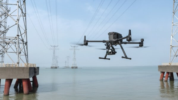
New Matrice 300 RTK and Zenmuse H20 Series Extend Airborne Intelligence to a New Generation of Work Ready to Embrace Digitalisation and AI
DJI, the world leader in civilian drones and aerial imaging technology, today unveiled its most advanced commercial drone platform, the Matrice 300 RTK (M300 RTK), and the Zenmuse H20 Series – a hybrid, multi-sensor camera. DJI engineered this all-in-one, high-tech solution to expand possibilities and exploit areas of work never explored before, for precise aerial inspections and data collection missions.
“With the M300 RTK flying platform and the Zenmuse H20 camera series, we are providing a safer and smarter solution to our enterprise customers” said Christina Zhang, Senior Director, Corporate Strategy at DJI. “This solution sets an entirely new standard for industrial UAV solutions, significantly enhancing operations across public safety, law enforcement, energy, surveying and mapping as well as critical infrastructure inspections.”
DJI MATRICE 300 RTK – Rewriting the Standard for the Commercial Drone Industry
The M300 RTK is the first ever DJI product that integrates modern aviation features, advanced AI capabilities, 6 Directional Sensing and Positioning System, a UAV health management system, and an impressive 55 minutes’ flight time[1]. Alongside AES-256 encryption and an IP45 weather resistant enclosure, the drone platform comes built-in with an all-new OcuSync Enterprise transmission system, which provides a triple-channel[2] 1080p video transmission[3] signal reaching up to 15 kmaway[4]. More versatile than ever before, the M300 RTK can support up to 3 payloads simultaneously and has a maximum payload capability of up to 2.7 kg. “For our teams working in the oil & gas industry, performance and safety are not optional. We cannot compromise on our pursuit of utilizing the best and most efficient tools available,” said Adam Serblowski, Robotics Theme Lead at Shell “The DJI Matrice 300 RTK proves to be an ideal upgrade over the existing DJI product line, and it helps us to further enhance the benefits of our drone programs. Our productive partnership with DJI will continue to help elevate safety in the world’s largest industry.“
Advanced Intelligence for More Efficient Data Acquisition
Combined, the M300 RTK and Zenmuse H20 Series solution offers users two intelligent ways to collect data:
Smart Pin & Track[5]: Intelligent functions that enhance synchronization of aerial intelligence in coordinated missions. It includes PinPoint, a function that allows users to mark the subject of interest and instantly share the precise location data to a second operator or if necessary to ground teams via DJI FlightHub; and Smart Track, which allows users to automatically detect and track a moving object, even at extreme distances, while synchronising the subject’s dynamic location in real time.
Smart Inspection: A new set of features developed to optimize routine data collection missions such as power lines, railway and oil and gas inspections. It consists of Live Mission Recording for recording sample automated missions in real time; AI-Spot Check[6] which enables data collection from exactly the same location every time, greatly improving the accuracy of automated missions. After photos from a sample waypoint inspection mission have been recorded, operators are able to mark the subject of interest. During subsequent automated flight missions, AI algorithms perform a comparison between the marked subject and current live view, thus correcting the camera orientation accordingly to deliver accurate and consistent results; and Waypoints 2.0 – an improved mission planning system offering up to 65,535 waypoints, while supporting an array of consecutive actions, 3rd party payloads, and more.
Aviation-Grade Situational Awareness
Inspired by today’s modern aircraft, the M300 RTK features a Primary Flight Display (PFD) that merges real-time flight and navigation data into one integrated display. Besides standard telemetry data like altitude and speed, the M300 RTK PFD provides obstacle data for visualising nearby obstacles during flight, enabling pilots to adjust flight trajectory if needed. These enhancements allow users to keep track of the aircraft while further enhancing the pilot’s situational awareness.
More Power at Your Fingertips
New to DJI’s commercial drone platforms and exclusive to the M300 RTK, is Advanced Dual Operator Mode – multi-pilot control protocols that enable the execution of missions with enhanced safety, reliability and flexibility. The M300 RTK, when controlled by two pilots, gives each pilot equal access to gain flight control priority, the transfer of which is displayed by a series of icons on the DJI Smart Controller Enterprise. Now, if one pilot becomes compromised or their controller loses battery or connection, the other pilot gains full control over the M300 RTK and its payloads. Additionally, when training new pilots, the teacher/main pilot can safely take over flight control – if and whenever necessary.
Improved Safety and Reliability
The M300 RTK comes with new and improved safety and reliability enhancements, including:
AES-256 Encryption: for secure data transmission of the command & control uplink and video transmission downlink.
AirSense (ADS-B technology): for enhanced airspace safety.
Anti-Collision Beacon: for increased aircraft visibility, especially in low-light conditions.
IP45 Protection Rating & Self-Heating Battery: for adverse weather conditions (-20 to 50° C).
6 Directional Sensing and Positioning System: offers a maximum detection range of up to 40 m horizontally, with options to customize the aircraft sensing behavior via DJI Pilot.
As with modern-day jetliners, the M300 RTK offers an integrated UAV Health Management System (UHMS) to optimize fleet maintenance. It records the aircraft’s flight data throughout its entire lifecycle, and utilizes the drone’s hardware and software systems to understand current aircraft performance and determine when it should be serviced. Taking advantage of this new system, users can get a quick overview of all critical aircraft systems, manage firmware updates across an entire fleet, track pilot hours and review flight missions.
DJI Zenmuse H20 Series – All the Sensors You Need – in One
To fit the new standards set by the M300 RTK, DJI has unveiled completely new camera payloads that radically improve mission efficiency. The Zenmuse H20 series offers DJI’s first ever Hybrid multi-sensor solution, allowing to capture any kind of images for industrial applications and public safety missions where efficient time management and immediate access to multiple layers of visions are paramount. The H20 Series is IP44 rated which protects enclosures from splashes of water from any direction.
The H20 series comes in two versions: The H20, a triple sensor with a 20MP, 23x Hybrid Optical Zoom Camera, a 12MP Wide Camera, and a Laser Range Finder covering distances from 3m-1200m; and the H20T, a quad sensor which adds a 640×512 Radiometric Thermal Camera, allowing operators to see what is invisible to the human eye thanks to high thermal sensitivity a 30 fps video definition.
An Integrated User Interface for smooth interactions
To enable pilots to operate so many sensors at once, the accompanying DJI Pilot app interface had to be completely rethought. In just a few taps the new User Interface lets pilots quickly switch between cameras and simplifies the process of zooming in and out by letting pilots preview the zoom FOV on top of the wide angle or thermal camera footage.
Maximum Flexibility with Quick Capture Modes
Thanks to its multi-sensor integrated UI design, the Zenmuse H20 series allows users to smoothly switch between wide, zoom or thermal cameras. Furthermore, it includes features for maximum flexibility when used on time sensitive missions. High-Res Grid Photo captures in one snap detailed imagery of defined subjects with the help of a custom grid. The imagescan be stored for later detailed inspection.
One-Click Capture: Capture videos or photos of up to three cameras simultaneously without having to manually switch between camera views or repeat a mission.
Night Scene: Gain clearer visibility when lighting conditions are not optimal.
Price and AvailabilityThe M300 RTK and Zenmuse H20 series are available for pre-order from official DJI Enterprise dealers and will start shipping in Q2 2020. Pricing details and information on where to buy will be available at your local DJI Enterprise Partners.
DJI Enterprise dealer map:https://www.dji.com/where-to-buy/enterprise-dealers
To find out more about the DJI Matrice 300 RTK: click here
To find out more about the DJI Zenmuse H20 series: click here
To download photos and videos of the M300 RTK and the Zenmuse H20: click here.
Watch the video of the new DJI M300 RTK: here
Join our webinar on May 14 to learn more about key features and new applications now possible for public safety and energy industries. Click here
[1] Actual flight time may vary because of the environment and payload configurations.
[2] Each RC supports two streams. Triple stream channeling is only supported with dual RC.
[3] Subject to payloads fitted on the drone
[4] Unobstructed, free of interference, when FCC compliant. Maximum flight range specification is a proxy for radio link strength and resilience. Always fly your drone within visual line of sight unless otherwise permitted.
[5] This feature is only supported when the aircraft is paired with the Zenmuse H20 Series payloads.
[6] This feature is only supported when the aircraft is paired with the Zenmuse H20 Series payloads.
DJI is a global leader in developing and manufacturing civilian drones and aerial imaging technology for personal and professional use. DJI was founded and is run by people with a passion for remote-controlled helicopters and experts in flight-control technology and camera stabilization. The company is dedicated to making aerial photography and filmmaking equipment and platforms more accessible, reliable and easier to use for creators and innovators around the world. DJI’s global operations currently span across the Americas, Europe and Asia, and its revolutionary products and solutions have been chosen by customers in over 100 countries for applications in filmmaking, construction, emergency response, agriculture, conservation and many other industries.
By PRESS
Award Augments Army’s $40 Million Initial Order for Black Hornets in Early 2019
ARLINGTON, Va., May 7, 2020 ― FLIR Systems, Inc. (NASDAQ: FLIR) announced it has won an additional $20.6 million contract from the U.S. Army to deliver its FLIR Black Hornet® 3 Personal Reconnaissance Systems (PRS). The advanced nano-unmanned aerial vehicles (UAVs) will support platoon- and small unit-level surveillance and reconnaissance capabilities as part of the Army’s Soldier Borne Sensor (SBS) program.
In January 2019, the U.S. Army awarded FLIR an initial $39.7 million contract for Black Hornet 3’s to support the SBS program. The company is currently delivering those systems for fielding across the force.
Extremely light, nearly silent, and with a flight time up to 25 minutes, the combat-proven, pocket-sized Black Hornet PRS transmits live video and HD still images back to the operator. Its information feed provides soldiers with immediate covert situational awareness to help them perform missions more effectively. FLIR has delivered more than 12,000 Black Hornet nano-UAVs to defense and security forces worldwide.
“Black Hornet has proven to be a game-changing technology – a small package that can deliver a big edge on the battlefield,” said Roger Wells, VP and general manager of the Unmanned Systems & Integrated Solutions business line at FLIR. “We’re proud to continue supporting the U.S. Army’s Soldier Borne Sensor program. Enabling warfighters with a full-range of integrated unmanned solutions, both in the air and on the ground, is a strategic objective FLIR shares with the military.”
The award-winning Black Hornet is designed and built by FLIR in Norway. Deliveries will begin in late 2020. To learn more about the FLIR Black Hornet® PRS, visit flir.com/products/black-hornet-prs/
By PRESS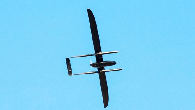
Latvian authorities are hunting a 26kg (57lb) drone that went missing mid-flight, causing air-traffic problems.
The aviation authority has restricted flights below 19,500ft (6,000m) in the region while they search for it.
While officials say it is likely the drone, which took off on Saturday, has landed, it had enough fuel to fly until 19:10 local time on Tuesday (17:10 BST).
Many members of the public reported sightings but none has been confirmed.
The non-military drone is understood to belong to a local unmanned aerial vehicle (UAV) manufacturer.
During a test flight, the company lost communications with the drone and lost track of its location, Latvian media reports.
About 3.5m long and 5.5m wide, with an airspeed of up to 70km/h (43mph), it was last seen flying at about 200m.
 Image copyrightLATVIAN CAAImage captionThe 26kg drone is about 3.5m long and 5.5m wide, with an airspeed of up to 70km/h
On Monday evening, the aviation authority said the possibility the drone was no longer in the air was becoming increasingly likely but multiple planes were still searching.
Despite lower air traffic across Europe due to the coronavirus pandemic, the errant UAV has caused some problems, closing airspace over Riga International Airport and causing the redirection of a flight from China to Tallinn
By BBC NEWS
PowerVision Robot Corporation, a global leader in smart drones, artificial intelligence, virtual reality, and augmented reality, has the ultimate drone to keep customers entertained rain or shine, the PowerEgg X. A first of its kind in the industry, the device features a revolutionary design that can easily be equipped with weatherproof accessories (waterproof case and landing float), allowing it to take off and land on water, as well as fly in heavy rain.
“Until now, if you wanted to fly your drone, you had to wait for ideal weather conditions,” said Wally Zheng, Founder and CEO of PowerVision. “With the introduction of the PowerEgg X, pilots, content creators, and hobbyists can fly without worrying about that small raincloud off in the distance. The device redefines what is possible with a drone by allowing users to capture incredible footage, rain or shine. Plus, it’s packed with incredible features for hobbyists and professionals alike!”
In addition to its game-changing weatherproof features, the PowerEgg X is also a high-performance drone equipped with a 4K/60fps camera and tri-axial mechanical stability augmentation technologies, making it perfect for aerial photography and videography. The drone features a flight time of 30 minutes, automatic obstacle avoidance, precise landing, intelligent flight modes, wind speed resistance up to 29-38 knots, 1080P image transmission within a distance of 3.7 miles, and much more.
Everyone has heard of the saying “April showers bring May flowers.” Now pilots can film all through April’s showers, as well as May’s flowers once it gets nicer out next month – all in 4k HD.
Pricing and Availability
The PowerEgg X is available now with an MSRP of $899 for the Explorer package and $1249 for the weatherproof Wizard package. The device is available at BestBuy.com, B&H Photo, Amazon.com and Powervision.me.
About PowerVision
With a mission to “innovate the future,” the PowerVision Group is a global technology leader focusing on UAV-related products and services, including smart drones, data visualization, and forecasting, virtual reality, and augmented reality. Founded in 2009, PowerVision Group employs around 500 employees globally in China, the U.S., Japan, Australia, Germany, and Finland. For more information, visit: http://www.powervision.me
By PRESS
Transport Canada provided much needed guidance to Canadian drone operators on March 26, 2020 in a new, dedicated drone chapter in the Aeronautical Information Manual (the “AIM”).
What is the AIM?
Generally, the AIM provides pilots and aircraft personnel with a single source document outlining applicable regulations, rules and procedures for Canadian aircraft operations. In addition to restating most of the technical requirements, it breathes life into the text of the applicable regulations and rules to assist pilots in conducting safe operations. The AIM is publicly available to all operators.
While Part IX of the Canadian Aviation Regulations (CARs) continues to contain most regulatory requirements applicable to drones operated within visual-line-of-sight, the drone chapter of the AIM provides clarity and additional, practical information essential for safe and compliant operations in Canada. Most helpfully, Transport Canada has now provided views of the spirit behind the text of Part IX of the CARs.
What does the drone chapter of the AIM cover?
In a detailed manner, the AIM addresses the key operational regulations that permit operators to conduct both basic and advanced operations safely (with helpful references to the CARs). Additionally, the AIM now includes direction from Transport Canada on a number of operational issues not previously addressed in any fulsome way by any regulation or government-issued direction.
While the entire chapter should be reviewed by drone pilots, the most interesting guidance for drone pilots relates to the following areas:
a) General flight safety guidance
The AIM acknowledges that drone pilots are “legitimate airspace users but are new entrants into a complex environment.” 1 Drone pilots are urged to take their role in the aviation environment seriously and to continuously take all “necessary steps” to ensure flight safety risks are mitigated.
The AIM notes that drone pilots should keep a “good safety margin” in all situations, but especially in advanced operations when flying closer to members of the public. If a drone pilot becomes aware of any situation while in flight that compromises aviation or individual safety, he or she must immediately cease operations.2 The AIM reminds drone pilots of the applicable fines should they fail to take such precautions, with individual penalties of up to $1,000 and corporate penalties of up to $5,000.
b) Micro drone rules
There was previously little commentary on the rules applicable to micro drones. Micro drone pilots are not subject to Subpart 1 of Part IX of the CARs and therefore do not need to register or obtain a certificate to fly. Despite the fact that micro drones remain relatively unregulated, the AIM clarifies that operators must adhere to CAR 900.06 to ensure “they do not operate their [drone] in such a reckless or negligent manner as to endanger or be likely to endanger aviation safety or the safety of any person.”3
c) Privacy laws to be respected
Drone operators must abide by Canada’s privacy laws, even though they are not detailed in the CARs. The AIM helpfully includes some instruction on abiding by privacy laws (which are in addition to guidance provided by Transport Canada in its Privacy guidelines for drone users) and the rules and regulations may apply to drones and their operators, including the Privacy Act, the Personal Information Protection and Electronic Documents Act and other applicable provincial privacy legislation. The AIM asks that pilots be “respectful of people’s privacy” and advise any individuals in the surrounding area of the purpose of their operations and clarifies that drone pilots must additionally obtain individual consent for the recording of any private information.4
For more discussion about privacy and drone operations, check out an earlier post here.
d) Radio monitoring by drone operators
The CARs do not require a drone operator to monitor or communicate with other aircraft or air traffic control using a radio (even when conducting advanced operations in controlled airspace). The AIM provides new guidance on the use of radios by drone pilots for the monitoring of nearby manned aircrafts. Drone pilots are now encouraged to access radios for monitoring air traffic frequencies and minimizing risk in non-standard flight operations. Radio access can additionally alert drone pilots to nearby traffic and potential airborne hazards by listening to information obtained from radio calls between other aircraft.
e) When bystanders are considered “part of the operation”
Transport Canada has provided some clarity in the AIM that allows operators to better determine which bystanders can be considered “part of the operation” and who are not (thereby allowing for more accurate observance of horizontal distance requirements during operations).
Individuals will be “part of the operation” if they (1) have been briefed on the drone hazard and (2) have the opportunity to leave the drone operation site should they feel uncomfortable. Such individuals include: construction site or mineworkers, film crews, or wedding guests and others involved in a wedding. People inside vehicles or buildings are not included in the 30-metre horizontal distance rule.6
f) Advertised events
Drone pilots must obtain Special Flight Operations Certificates (SFOC) when operating less than 100 feet away from the boundaries of an advertised event.7 The CARs definition of “advertised event” includes an outdoor event that is advertised to the general public, such as a concert, performance, festival, market, or sporting event.8 The AIM provides important and practical guidance on how to determine the boundaries of advertised events (including those segregated from the public by a fence or where there is no clear fence/boundary, such as firework displays, skiing events and triathlons), making it easier for drone pilots to ensure they are compliant with their safety obligations when operating nearby.
g) Record keeping details
The AIM outlines the applicable record keeping requirements for drone owners, including particulars on potential Ministry of Transportation requests. Drone owners must keep a record of the names of the pilots and crew members involved in each flight and, in respect of the system, the time of each flight or series of flights. Records must also be kept on the particulars of any mandatory action, maintenance, modification or report performed on the system.9
h) Tethered drone usage
Guidance is provided within the AIM on Transport Canada’s interpretation of the applicability of the CARs to tethered drones. As tethered drones are by nature prevented from being maneuvered or navigated, they do not meet the CARs definition of a drone10 and are therefore not subject to regulation under Part IX of the CARs.
Tethered drones must still adhere to the rules and obstruction requirements of CAR Standard 621 Chapter 11, which require, among other things, that tethered objects have markers and lighting when in use.11
Conclusion
Overall, the drone chapter of the AIM acknowledges the interplay between the various rules and regulations applicable to drone use in Canada and provides clear direction from Transport Canada on its interpretation of such provisions. Drone pilots must review the AIM in conjunction with all applicable regulations when implementing their own safety practices and procedures.
Organizations establishing their own drone programs, policies and procedures are well advised to review the AIM to ensure their operations are compliant with both the text and spirit of the CARs.
For more information, please contact Kathryn McCulloch or any other member of Dentons’ Aviation team.
A special thank you to Liz McLellan, articling student, for her assistance with this post.
By Kathryn McCulloch