User blog: Bruce McPherson
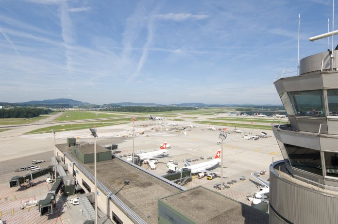
Geneva, 1 April 2021 – The Swiss air navigation services company Skyguide is opening Switzerland’s first centre of competence for UFO (unidentified flying object) activity as of today, 1st of April 2021. The perceived increase in sightings of unidentified flying objects in the airspace controlled by Skyguide has prompted the air navigation service provider to get to the bottom of these phenomena in greater detail.
The UFO Competence Centre is housed in the building of the Area Control Centre in Wangen near Dübendorf (Zurich) and has three staff members who specialise exclusively in UFOs. Furthermore, an additional workplace is being created in the control tower for a specialised air traffic controller who focuses on the observation of unusual flying objects.
Intensive training in preparation for new tasks
The staff of the UFO Competence Centre underwent intensive training a few weeks ago in order to be able to master their future activities. This included simulated UFO activities on the radar and in the tower simulator. They also reviewed documentary material (such as the Roswell crash or UFO video recordings from the US Navy), as well as the study of spaceships and their flight behaviour in well-known science fiction feature films. This all-round training enables Skyguide’s UFO experts to quickly detect and document unidentified flying objects.
Cooperation with governmental and private space organisations
Thanks to existing and future space missions by governmental (e.g. ESA, NASA, etc.) and private (e.g. SpaceX) organisations, Skyguide is expecting an increase in intergalactic traffic.
This opens up completely new fields of activity and cooperation for Switzerland’s air navigation services in the future.
By PRESS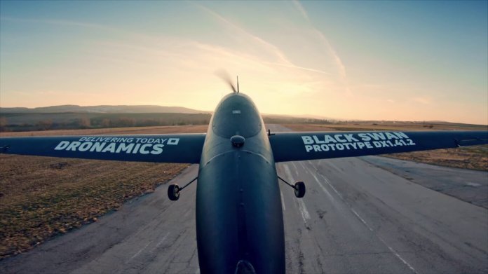
DRONAMICS the world’s leading developer and operator of large cargo drones, announces the launch of DRONAMICS Airlines with companies in Ireland, Australia and Canada that will manage the airfreight operations for same-day delivery services with its proprietary unmanned cargo drone – The Black Swan. As part of its ramp-up for commercial operations, the company appoints the seasoned aviation executive Sergio Oliveira e Silva as the new Chief Operating Officer (COO), a new senior management team position.
Sergio joins the organization from his former position of Managing Director, Asia of a Global aviation services public listed company. Over a 25-year career, Sergio has held executive-level positions with some of the industry’s largest operating companies within different international regions for privately held and publicly listed companies.
The three newly founded subsidiaries are incorporated in the respective countries as they are leaders in drone regulations, but also are the regions of the first customer cases that will be serviced in e-commerce, pharma and spare parts logistics which will be revealed later this year.
Svilen Rangelov, Co-Founder & CEO at DRONAMICS said: “This is an important milestone for us, and we are thrilled by the talent we are attracting to our organization that is embracing our vision to democratize airfreight. We will continue enhancing our experienced management team who will provide additional expertise to deliver our first commercial flight in a near future.”
Sergio Oliveira e Silva, COO at DRONAMICS, said: “I’m very much looking forward to being part of the team that will bring into the market the next-generation logistics networks for e-commerce, pharma, agriculture shipments, special cargo, and spare parts. I am excited to be again involved in another successful pioneer venture within the aviation logistics industry”.
As a COO of DRONAMICS, Sergio will be responsible for the set-up and operations of the airline business, the deployment of the droneport network, and the upcoming operational authorizations under the fast-evolving drone regulations around the globe. The appointment comes as the first step in building up our global structure that will support the roll-out of the same-day delivery service of DRONAMICS.
About DRONAMICS: Based in London (UK) and Sofia (Bulgaria), DRONAMICS is the world’s leading developer and operator of large cargo drones. Its flagship Black Swan unmanned aircraft is able to carry 350 kg of cargo at a distance of up to 2,500 km at up to 80% lower cost than any aircraft in existence, enabling same-day shipping over very long distances for e-commerce, pharma, and time-critical shipments. Founded in 2014 by the Rangelov brothers, an economist and an aerospace engineer, the company’s fast-growing team includes some of the world’s top aerospace and logistics experts and is the winner of numerous awards for innovation, including IATA’s Drone Innovation Award. A private company, DRONAMICS is funded by leading entrepreneurs and executives in aviation, logistics, and technology from the US, Europe, Africa and Asia, as well as by Founders Factory, Speedinvest and Eleven Capital.
DRONAMICS is IATA’s first Strategic Partner for drones worldwide and has been named by the European Commission as a Top 10 EU-Africa startup.
www.dronamics.com
We wrote about DroneUp’s drone delivery of Coke with Coffee to residents in Coffee, GA – but how exactly did that delivery work? The A2Z Rapid Delivery System allowed packages to be delivered without landing the drone – a method that solves a lot of problems in drone delivery.
CA-based A2Z Drone Delivery, LLC, has developed a patented tethered freefall drone delivery mechanism, the Rapid Delivery System (RDS1) used by DroneUp® for the project with Walmart and Coke. The RDS1 system lowers the delivery to the ground by tether – which means that homeowners don’t have to worry about a noisy landing or the potential for a landing drone to hit obstacles on its way down. “The RDS1 was chosen for its rapid delivery capabilities which reduced time-on-station to just 30 seconds per delivery, while minimizing intrusive rotor noise and limiting the window for risk to people on the ground,” says an A2Z press release.
“For our partners at DroneUp to put their trust in our system was the best proof of concept that we could imagine and was a memorable benchmark for our whole team,” said Aaron Zhang, founder of A2Z Drone Delivery, LLC. “The unique capabilities of the RDS1 were tailor-made for this type of residential delivery where our tethered freefall mechanism can accurately and quickly deposit payloads while hovering far from people, homes, trees and utility wires.”
Many of the concerns about the safety of drone delivery – and the impact on communities – is based upon the very end of the mission, when the drone lands.

“By delivering payloads without having to descend from cruising altitude, the A2Z Drone Delivery RDS1 mitigates the safety and privacy concerns often associated with drone delivery by keeping spinning UAV propellers away from people and abating intrusive rotor noise of low-flying drones,” says the press release.
“With the innumerable logistics that go into residential drone delivery, it’s important to have confidence in every aspect of the hardware from the UAV platform to the delivery mechanism,” said John Vernon, the CTO of DroneUp. “The RDS1 allows our pilots to reduce time-on-station to about 30 seconds per delivery. Combined with the ability to make deliveries from cruising altitude, this rapid delivery and the integrated safety features in the tether system itself, help us assuage some of the public concerns over UAV delivery.”
A2Z’s RDS1 is designed to meet the concerns of regulators and consumers, says the company:
To ensure payloads are secure throughout the flight, the RDS1 features extensive integrated safeguards. An automated pre-flight weight check ensures the flight platform is not overloaded before the RDS1’s built-in payload status detection monitors track the payload throughout flight and delivery. Manual delivery control is backed up by intelligent safeguards that calculate the payload freefall and when to slow the descent to the ground, while a passive payload lock protects against package loss in the event of a power fluctuation. Should the UAV experience an emergency, the payload and tether can be abandoned to save the aircraft, and protect the safety of people and property on the ground.
“No matter how many flight hours you have as a UAV pilot, adding the dynamic of delivering packages to the ground is still a new concept, so having the tether controls seamlessly integrated into the pilot software is imperative,” said DroneUp pilot Ethan Burnette, who flew delivery missions with the RDS1. “Also, knowing the redundant safety systems are in place gives you the added peace of mind you need as you become accustomed to flying a drone with a payload slung below it.”
By: Miriam McNabb DroneLife
Are you an experienced remotely piloted aircraft operator who has a passion for aviation and motorsport?
THE COMPANY
Since 2016, Alauda Aeronautics have been developing the world’s first electric flying racing car. Our reason for racing can be found in the simple truth that nothing drives innovation faster than competition. Our racing series – AIRSPEEDER, provides us with a platform for racing which will drive developments of new technology. Once upon a time, people fell in love with flying. We’re bringing that adoration back in the form of a new aerial motorsport that will kickstart a new era of aviation.
To test the developing technologies in the growing electric vertical take-off and lift (eVTOL) industry, Alauda is refining a high-performance version of its unmanned remotely piloted aircraft system (RPAS) to promote its innovative flying displays. With expansion of the team, a full-time opportunity for Chief Remote Pilot is now available, based from company headquarters in Adelaide, South Australia.
THE ROLE
The Chief Remote Pilot provides regulatory and procedural leadership and guidance to the company and its team of Remote Pilots, ensuring compliance, training, and operational goals are achieved. You will oversee flying operations for Alauda, including the assessment of Remote Pilots to ensure readiness, and the safety, coordination and approval of flights during operational events. This role is also instrumental in providing input to the engineering team to refine the aircraft and its handling qualities.
MAIN RESPONSIBILITIES
- Ensuring that operations are conducted in compliance with regulatory requirements
- Maintaining qualification and training records for all Remote Pilots
- Monitoring and maintaining operational standards and supervising Remote Pilots who work under the authority of the Remote Operating Certificate
- Maintaining a complete and up-to-date reference library of manuals and operational documents as required by regulators for the class of operations conducted
- Developing applications for approvals, exemptions and permissions where required to facilitate operations
- Developing checklists and procedures relating to flight operations.
EXPERIENCE AND SKILLS REQUIRED
- A current CASA Remote Pilot Licence (RePL) including the category of multi-rotor and/or helicopter
- Demonstrable experience in flying manual mode or FPV, not just autonomous or GPS-assisted flight (advantageous)
- A CASA-recognised flight crew licence such as CPL/PPL (A) or (H)
- A CASA-recognised instrument rating
- Training & assessment qualifications, such as pilot instructor qualifications or current Certificate IV in Training & Assessment
- Experience working with company Operations Manuals and Procedures Libraries ,and development of documentation for regulatory compliance
- A current Australian car drivers licence
The successful candidate will be rewarded with the opportunity to be part of a great team, great company and to pioneer the way in a new generation of sport, innovation and aircraft technologies.
Airspeeder/Alauda is an Equal Opportunity Employer; employment with us is governed on the basis of merit, competence and qualifications and will not be influenced in any manner by race, colour, religion, gender, national origin/ethnicity, age, sexual orientation, gender identity, marital status, mental or physical disability or any other legally protected status.The application form will include these questions:
- Which of the following statements best describes your right to work in Australia?
- Do you have a current Australian driver’s licence?
- What’s your expected annual base salary?
- How much notice are you required to give your current employer?
- Are you willing to relocate for this role?
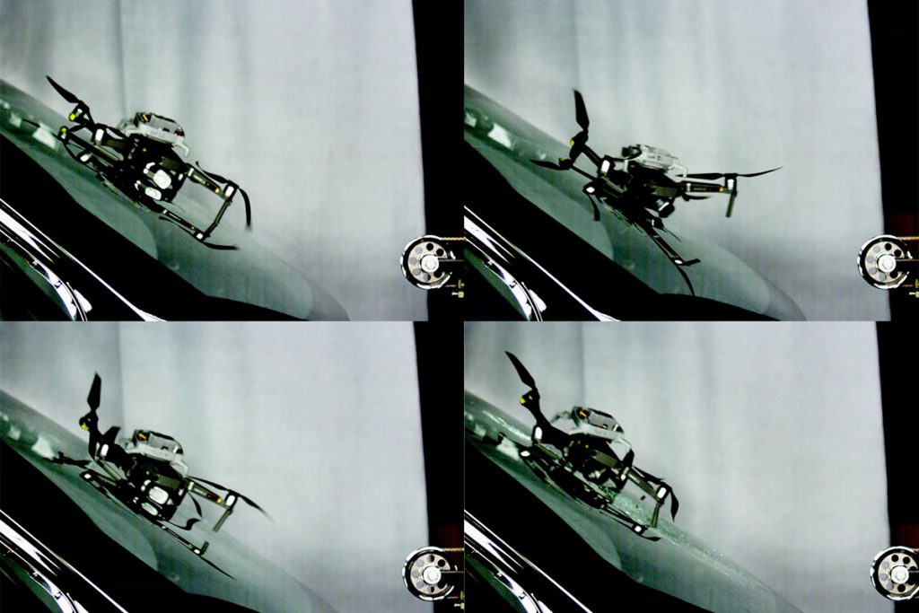
A drone slams into a windshield. The drone's shell cracks, and the windshield shudders. Pieces of a propeller snap off. But the windshield doesn't shatter.
Most safe drone flights aren’t supposed to end in crashes. But this crash is unfolding in one of Virginia Tech’s impact labs, where controlled collisions have been pivotal to producing safer cars, football helmets, and even toys. Here, collisions reveal information about risk and point to ways to reduce it. Now they're helping lead to new ways to use drones.
For years, an important Federal Aviation Administration (FAA) regulation restricted commercial drone use in urban and suburban areas by prohibiting flying over moving vehicles. The concern was that a drone hitting the windshield of a moving car could obliterate the driver’s view of the road or, worse, injure the occupants.
Data demonstrating that a small parachute-equipped drone wouldn’t actually damage a car traveling at typical in-town speed limits provided a counterpoint to those concerns – one convincing enough to the FAA that it granted insurance company State Farm a waiver to operate drones over moving vehicles in 2019.
The data represent the first known example of direct research on drone-automobile collisions – a unique collaboration between drone specialists at the Virginia Tech Mid-Atlantic Aviation Partnership (MAAP), injury biomechanics experts in the university’s College of Engineering, and State Farm.
The waiver provided the company with an additional tool to use in processing homeowners insurance claims.
At the end of 2020, the FAA issued new rules that expanded permissions for drones to fly over moving vehicles. But the more restrictive rules in place when State Farm and MAAP started working on the project would require a drone operator assigned to inspect two houses across a busy street from each other to finish the first inspection, land, walk the drone across the street, and start all over just a few feet away. The waiver allowed the drone to fly from one house to the other instead.
State Farm has been working with MAAP for several years to safely incorporate drones into its business operations. As an FAA-designated drone test site, MAAP is one of a handful of groups leading research that will guide the safe integration of drones in the United States.
“State Farm claims inspections are the kind of operation where drones can offer huge advantages,” said Mark Blanks, MAAP’s director. “They also required a meaningful expansion of the existing regulations. The intersection of those factors — an opportunity to help realize the potential of this technology that will also advance the industry as a whole — is exactly where our mandate lies as a test site.”
In the aftermath of the 2018 hurricane season, the partnership between State Farm and MAAP yielded the first nationwide waiver for drone operations over people. This new waiver was another industry first.
“State Farm is committed to finding innovative opportunities that support safety and efficiency in our claims handling,” said State Farm Manager Todd Binion. “If we look for ways to use data to help overcome regulatory challenges, we can move forward in other ways where drones can be used to benefit consumers across multiple industries.”
Getting a waiver that’s never been granted before, for technology that’s rapidly evolving and being used in new ways, means finding ways to define, quantify, and categorize risks in new and novel ways.
“What the FAA wants to see is a compelling, credible case that the operation is safe,” Blanks explained. “You need extensive data that’s grounded in the context of how the operation will work in the real world. There wasn’t any empirical information on what would happen during an impact between a drone and a car, so in order to craft a strong waiver application, we had to come up with research methods to obtain that information.”
MAAP regularly collaborates with Virginia Tech’s acclaimed injury biomechanics researchers. The group, led by associate biomedical engineering and mechanics professor Steve Rowson, has earned international recognition for experimental methods that precisely recreate real-world collisions. These techniques offer a realistic and, crucially, reproducible way to quantify the risk of various impacts and evaluate the efficacy of safety measures.
The drone the team used was DJI Mavic 2 Pro, a small aircraft that weighs just over 2 pounds. State Farm’s waiver application specified that during operations the drone would be equipped with a parachute from Israeli company ParaZero, technology that has been tested against ASTM standards and has figured in multiple successful applications for waivers to fly over people. The researchers set out to replicate what might happen if, in the unlikely event of a catastrophic failure, the drone under the parachute was blown directly into the path of a moving vehicle.
They mounted the drone to a pneumatic sled that was propelled down a linear track toward a custom-built windshield frame that contained parts of a salvaged Toyota Camry. By varying the impact speed - which would translate to the speed of a moving vehicle in a real-world scenario - and assessing the damage, the team hoped to identify a threshold below which a drone could safely be flown overhead without risking a smashed windshield if something went wrong. (A similar setup, with a crash test dummy at the business end of the track, had supported their earlier research on drone impacts with humans.) They expected the degree of damage to the windshield to increase steadily as the impact speed rose.
Post-impact inspections showed a more interesting result. At impact speeds between 25 and 62.5 mph, the only signs of the collision were streaks of rubber and plastic transferred from the drone as it slid up the glass. When the Mavic hit at 67 miles per hour, a web of cracks shot across the windshield as it bowed inward, spitting shards of glass onto the floor.
The slim margin between a virtually pristine windshield and a destroyed one drew a clear boundary around low-risk scenarios. The waiver application argued that as long as potential relative impact speeds never exceeded 62 mph, flights over moving vehicles presented minimal risk. The FAA agreed.
Using the waiver in the field takes some consideration of the environment. The speed at which a drone would hit a windshield is the sum of the vehicle’s speed and the speed of the wind pushing the drone toward it. In the average suburban neighborhood, with speed limits between 25 and 35 mph, even the maximum wind speed the drone can tolerate — about 23 mph — would still keep potential impact speeds below the 62 mph threshold.
The FAA’s more permissive rules for flights over moving vehicles are slated to take effect this spring. However, Blanks said, research like this will continue to be valuable for companies pursuing the highest standards of safety.
“If you're dedicated to thoroughly understanding and mitigating risk in their operations, having direct, quantitative data about the consequences of an impact is going to remain relevant,” he said. “The fundamental principles and test methods have provided insight for standards development and rulemaking, and they’ll continue to be part of the foundation of safety that’s going to be crucial to this industry as it matures.”
For years, decreasing fuel tax revenues have required state transportation departments and the contractors they partner with to find new and inventive ways to do more with less.
But welcome to the world of construction, right?!
AASHTO estimates a $37 billion decrease in state DOT revenue between 2020 and the end of 2024.
So what are DOTs, contractors, and consultants to do?
Advances in Unmanned Aerial Systems (UAS) have provided several opportunities for doing more with less.

Good, Fast, Cheap, but not all 3… Unless you’re talking about drones.
There’s an old adage that often gets associated with the world of construction…
‘You can have something done well, you can have it done fast, or you can it done cheaper than the next guy — but you can only pick two.’
With the skillful use of drones however – DOTs, contractors, consultants, and surveyors especially – all three advantages can be had.
High ROI Drone Use Cases
Roadway Mapping: Survey costs can be cut by as much as 85% by using drone enabled photogrammetry instead of terrestrial scanning.
What’s more are the economies of scale afforded by UAS supported surveys. The labor saved by making use of drones becomes exponentially greater as the project gets larger.
For example, if a 1.5 mile mapping project that requires roughly 40 labor hours from a UAS supported survey crew were to grow by 5x, the larger project wouldn’t require 200 labor hours. A similarly scoped project 8 miles long might only require 70 hours to complete with the use of drones.
Now, photogrammetry isn’t always a complete substitute for terrestrial scanning, but drone enabled LiDAR often can be. Project scope and needs will always be the deciding factor.
Measuring Quantities: West Virginia’s Department of Transportation found that survey crews could calculate stockpile quantities with 90% less labor when using drones.
Such a task used to require more than 40 surveyors over 2 weeks (3,200 labor hours). The same work can now be done by 7 people in just 1 week (240 labor hours).
Similar labor savings can be seen by civil contractors looking to calculate quantities before, during, and after earthwork operations.
Not only is the data collection more efficient, but the point cloud and surface models generated afford the contractor to make more accurate calculations.
Bridge Inspections: UAS enabled bridge inspections require 80% less labor, than inspections performed by snooper trucks.
A bridge inspection that might normally require 6 people and 48 labor hours using a snooper truck can be done in 4 hours by 2 people (8 labor hours).
Not only does this provide savings to the DOT or the consultants contracted to perform these inspections, but there are additional savings associated with the supporting operations like traffic control and the economic cost associated with disrupting the public’s use of the asset.
These UAS enabled inspections also provide a more thorough record of the asset’s condition at the time of inspection by way of the uniform capture patterns made possible by the UAS flight planning software.
Skynetwest | Mapping & Inspection Data Collection
Skynetwest is a team of qualified data retrieval specialists, experienced in capturing data to support the efforts of registered land surveyors and engineers.
Have Questions?
Call or text Brendan Alan Barrett at 281-857-6543
By PRESS
Pioneering scientists lead the research of marine mammals utilizing drones in the most epic ways.
| ||||||||||||||
|


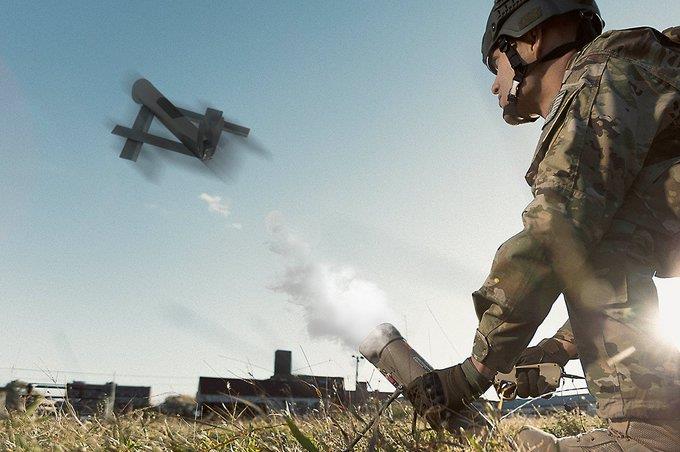
The UK plans to buy the AeroVironment Switchblade loitering munition, in what appears to be the first purchase of the US-made weapon by a foreign country.
The sale was disclosed by the US Department of Defense (DoD) in an online notice on 16 March. The value of the deal, number of munitions sold or type of Switchblade were not disclosed, though the DoD said it was part of “Foreign Military Sales (United Kingdom) funds”. It is not clear what military service within the UK purchased the Switchblade.
AeroVironment declines to comment directly on the sale, but says: “As we discussed in our third quarter earnings conference call on 9 March, we received US government approval for the first export of our Switchblade 300.” The company said in its earnings call that it would not disclose the customer.
“This is an important milestone for us as we market Switchblade’s unique capabilities to international customers,” says Wahid Nawabi, chief executive of AeroVironment. “We believe additional demand from close US allies will also be forthcoming. We expect Switchblade exports to take place within the US government’s Foreign Military Sales programme as opposed to direct commercial sales.”
The 300-variant is the earliest type of the Switchblade. It is smaller and intended as an anti-personnel munition. The loitering munition is man-portable and has a range of 5.4nm (10km).
Last October, AeroVironment unveiled its Switchblade 600, a loitering munition with a larger warhead that is effective against light-amour. That weapon is also man-portable and has a range of 43nm.
By Garrett Reim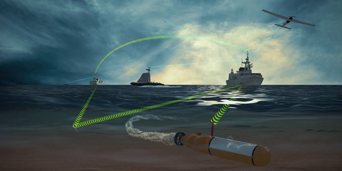
| A team of autonomous industry experts lead by Kongsberg Geospatial along with Four DRobotics Corp and SeeByte have been contracted by Weir Marine Engineering to develop and test a Maritime Multi-Domain Control System (MMDCS).Ottawa, ON – Team Cohort, a team of autonomous industry experts comprising Kongsberg Geospatial, Four DRobotics Corp and SeeByte, have been awarded a contract from Weir Marine Engineering to develop and test a Maritime Multi-Domain Control System (MMDCS). The system will allow operators to simultaneously operate multiple autonomous vehicles in the air, on the water, and underwater – all from a single shipboard control station. The system could allow Royal Canadian Navy (RCN) warships to effectively extend their sensor range using autonomous vehicles, while providing protection from seaborne threats such as mines or hostile unmanned craft. The MMDCS is a challenging project that requires experience with the deployment of autonomous unmanned vehicles, and operations of maritime control stations, as well as existing and emerging NATO standards including Stanag 4586 and 4817. This specialized knowledge and expertise is provided by the team of Kongsberg Geospatial and Four DRobotics Corp of Ottawa, Canada, and SeeByte of Edinburgh, Scotland. For this project, Kongsberg Geospatial will provide operator control stations based on its IRIS UxS vehicle command and control software product – which provides an overall real-time picture of the terrain, airspace, and underwater environment where the ships and their supporting UxV (Unmanned [X] Vehicle) teams are operating. Four DRobotics Corp and SeeByte will provide goal-based mission planning and reasoning (AI-supported) software systems to support autonomous mission development and execution for a UxV team consisting of an Unmanned Aerial Vehicle (UAV), an Unmanned Surface Vehicle (USV), and an Unmanned Underwater Vehicle (UUV). The MMDCS will provide a tactical capability for the command and control and information management required to simultaneously support unmanned vehicles in all three naval operations domains, including air, surface, and sub-surface. The final objective of the project is to provide real-time or near-real-time situational awareness for warships in all three domains: underwater, on the water, and in the air – allowing improved threat assessment and target engagement. The development and testing of the prototype MMDCS is expected to be completed by mid 2021. |
| Background Maritime Multi-Domain Control Station (MMDCS) The MMDCS will provide a tactical/force level capability for the command, control and information management to support marine vehicle types in all three naval operation domains air, surface, and sub-surface. Primary purpose of the contract is to establish the requirements for an MMDCS advanced development model (ADM) to Technology Readiness Level 5-6 for the Halifax and Kingston-class but also considering the RCN future fleet such as the: Harry DeWolf-class, Protecteur-class, and the Canadian Surface Combatant. The focus of the ADM is on operations. Ideally, all major vessels of the RCN could employ the MMDCS. The objective is near real-time generation of situational awareness in the maritime domain battlespace as well as decision support tools for mission-planning, data exploitation, real-time platform and sensor deployment, threat assessment, and target engagement using automated processes to assist human decision-making across all three maritime domains: underwater (UUV), on-the-water (USV), and well above the water (UAV). NATO Stanag 4817 Multi-Domain Control Station NATO Stanag 4817 is a protocol that is in development by NATO member countries Partners for Peace (PfP), and Israel. The purpose of 4817 is to support common interoperability between a Ground Control Stations and unmanned vehicles in all domains including: air, sea, underwater, and ground. 4817 is a successor to NIAG studies NIAG SG-157 and NIAG SG-202 and is compatible with NATO Stanag 4586. About Kongsberg Geospatial: Based in Ottawa, Canada, Kongsberg Geospatial (http://www.kongsberggeospatial.com) creates precision real-time software for mapping, geospatial visualization, and situational awareness. The Company’s products are primarily deployed in solutions for air-traffic control, Command and Control, and air defense. Over nearly three decades of providing dependable performance under extreme conditions, Kongsberg Geospatial has become the leading geospatial technology provider for mission-critical applications where lives are on the line. Kongsberg Geospatial is a subsidiary of Kongsberg Defence Systems. Media contact: 1-800-267-2626 or reach us by email at info@kongsberggeospatial.com About Four DRobotics Corp: Formerly known as Cohort Systems Inc., Four DRobotics Corp is based in Ottawa, Canada. Four DRobotics Corp https://www.fourdrobotics.com/ is a Canadian owned small medium enterprise with business development offices in Ottawa and Beloeil, Quebec. The company develops autonomous vehicles that employ Goal Based Reasoning and Deep Learning for the Autonomous Vehicles as a Service business model. The company is focused on the application of this business model to the physical security of critical infrastructure. Media contact: (613) 806-8007 or email Clinton Joseph at clinton.joseph@fourdrobotics.com, or info@fourdrobotics.com. About SeeByte: Headquartered in Edinburgh, Scotland, SeeByte (http://www.seebyte.com) has achieved a position of leadership in the development of smart software for underwater vehicles, sensors and systems in both the Military and Oil & Gas sectors. SeeByte provides products and services to major government and commercial clients around the world. SeeByte is a subsidiary of Battelle. Battelle is a leader in maritime technologies; enabling rapid development and deployment of solutions for government and industry. |

A scheduled flight from Sudan to Qatar was forced to return to its origin after the cockpit was hijacked by a furry infiltrator. The clawful situation arose after a cat, thought to have stowed away during cleaning, woke up and became terrified by his new surroundings. He attacked the captain, causing the plane to return to Khartoum and giving passengers a hiss-terical story of a flight gone wrong.
Tarco Air flight has an appawling outcome
Some aviation stories are pawsitively unbelievable, but in this case, we’re not kitten around. A Tarco Airlines flight from Khartoum (KRT) to Doha (DOH) had to return to its origin after pilots encountered a fur-midable opponent shortly after takeoff.
The Boeing 737 departed Khartoum on time, and was around 30 minutes into its journey when a cat-astrophe occurred. A feline stowaway appeared unexpectedly in the cockpit, to the great surprise of the Sudanese pilots.
According to reporting in Al-Sudani, the kitty was not a happy passenger, and proceeded to attack the captain. While the crew made every attempt to capture the aggressive stowaway, it proved impossible to get near the furry hijacker. Unable to continue the journey, the pilots set about returning to Khartoum, to the surprise of the passengers onboard.

Crew were surprised to find company in the cockpit. Photo: Tarco Aviation
While you might assume the naughty cat was an escapee from a passenger’s on-board belongings, it seems he was more likely to be a feral feline who sought a comfortable place to rest. Al-Sudani reported that the plane was stationary in the hangar overnight for cleaning and preparations. It is believed that the cat crept onboard and found a comfortable spot to rest in the cockpit.
Of course, the ICAO code for Khartoum – HSSS – is completely coincidental, but beautifully expresses the emotion felt by the cat at finding he was several thousand feet in the air.
Not the first cat-attack in the air
Although this story is somewhat unusual, more surprising is that it’s not the first time this type of incident has occurred in the air. In August 2004, a Brussels Airlines pilot became a victim of a claw-ful experience when an escaped feline ran wild in the cockpit.
The aircraft, an Avro RJ, was traveling from Brussels to Vienna with 62 people onboard when a cat appeared in the cockpit. The animal had apparently escaped from its airline-approved container and began scurrying around the cabin. A member of cabin crew opened the cockpit door to serve refreshments to the flight crew, and the kitty seized the opportunity.

Before their retirement, a Brussels Airlines Avro RJ had a feline incident also. Photo: Brussels Airlines
Probably attempting to escape his flying prison, the cat shot into the cockpit and promptly found he was even more trapped than before. It reportedly became very agitated, and began scrabbling around the flight deck, scratching the co-pilot on the arm. Worried about the damage the creature could do to the cockpit’s sensitive equipment, the pilots took the decision to turn back to Brussels around 20 minutes after takeoff.
The airline described the situation as a ‘freak incident,’ claiming that a lot of coincidences had converged, leading to the unusual occurrence
For Tarco Airlines, this is likely one to chalk down to experience. As we’ve seen in the past, cats can be masters of infiltrating even the most secure of spaces, so they might want to step up their pre-flight checks to avoid a similarly hiss-terical situation in the futurby Joanna Bailey