Site blog
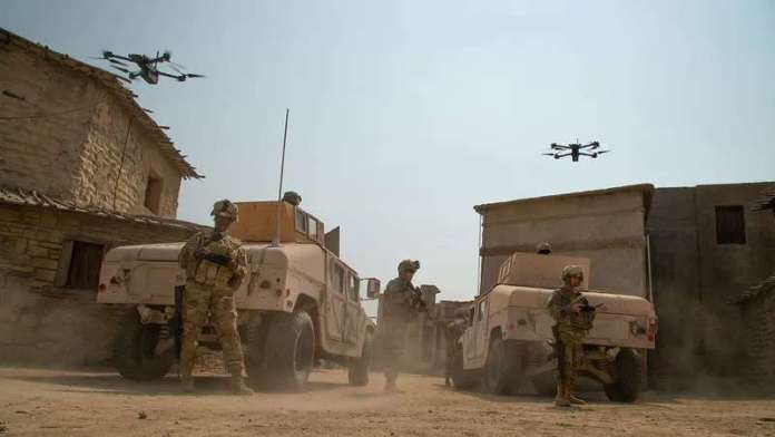
REDWOOD CITY, Calif. – February 8, 2022 – Skydio, the leading U.S. drone manufacturer and world leader in autonomous flight, today announced the U.S. Army has selected the Skydio system for its Short Range Reconnaissance (SRR) Program of Record. This contract has a base year value of $20.2 million, ensuring Soldiers have access to the world’s most advanced autonomous drone technology. The Firm-Fixed-Price Five Year Production Other Transaction (OT) agreement will be worth up to $99.8 million over the period of performance.
Managed by the Program Executive Office for Aviation’s Unmanned Aircraft Systems (PM UAS) Project Management Office, the SRR program aims to equip Soldiers with a rapidly deployable small UAS solution to conduct Reconnaissance and Surveillance (R&S) activities. After evaluating proposals from over 30 small UAS SRR vendors, and rigorous testing of five finalists in partnership with the Defense Innovation Unit, the U.S. Army chose Skydio for final integration based on Soldier feedback and design review packages intended to assess the overall product performance, quality, and production readiness.
“This is an exciting milestone for Skydio, the Army, and most importantly the men and women who serve our country. For drones under 20 pounds, civilian drone technology has raced ahead of traditional defense systems. With the SRR program, our Soldiers will now have access to the most advanced capabilities in the world in this class,” said Skydio CEO, Adam Bry. “Skydio drones deliver unparalleled situational awareness and ease of use in the most demanding situations thanks to Skydio Autonomy. We are proud to work with the Army and look forward to fielding these units, while continuing to pioneer the capabilities that provide our troops with the real-time data needed to successfully and safely complete their missions.”
“The selection of the U.S. Army’s short range reconnaissance provider for tranche 1 is a significant milestone for the Army, our strategic partners and the domestic industrial base. The future for our Soldiers is now,” said Col.Joseph Anderson, Project Manager for Unmanned Aircraft Systems. “The relationships we have formed with industry demonstrate our commitment to compete and our ability to lead and innovate advanced technology in unmanned systems.”
Skydio X2D is the ultimate solution for military and defense customers to perform reconnaissance, search and rescue, and security patrol missions. Skydio X2D pairs Skydio Autonomy, the world’s leading AI-driven flight autonomy software, with a foldable, highly portable airframe that leverages hyper-strength composites to withstand the most demanding environments. X2D features dual color optical thermal sensors, and is equipped with GPS-based night flight and strobe lighting, making it ready for both day and night operations, while providing up to 35 min of flight time on a single battery. Designed, assembled, and supported in the USA, X2D complies with the NDAA’s rigorous supply chain security requirements and offers superior cybersecurity protection.
About Skydio
Skydio is the leading U.S. drone manufacturer and world leader in autonomous flight. Skydio leverages breakthrough AI to create the world’s most intelligent flying machines for use by consumers, enterprises, and government customers. Founded in 2014, Skydio is made up of leading experts in AI, robotics, cameras, and electric vehicles from top companies, research labs, and universities from around the world. Skydio designs, assembles, and supports its products in the U.S. from its headquarters in Redwood City, CA, to offer the highest standards of supply chain and manufacturing security. Skydio is trusted by leading enterprises across a wide range of industry sectors and is backed by top investors and strategic partners including Andreesen Horowitz, Levitate Capital, Next47, IVP, Playground, and NVIDIA.
By PRESS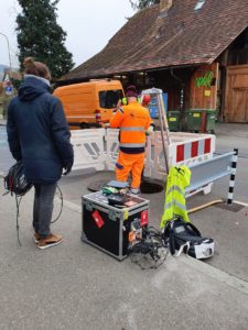
Flyability and WinCan Partner on Wastewater Inspection Solution
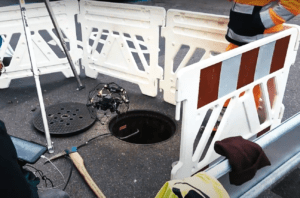
Indoor drone provider Flyability has formed a partnership with sewer inspection software provider WinCan in order to make sewer inspections safer, quicker, and more cost effective.
Wastewater inspection professionals are increasingly employing Flyability’s Elios 2 drone to collect visual data inside sewer pipes. This new partnership will now enable inspectors to import their gathered data directly to WinCan’s sewer inspection software, where they can then process it, analyze it, and create detailed, standards-compliant reports.
Using Flyability Drones for Wastewater Inspection
“This partnership with WinCan will bring to wastewater inspection professionals more than a data acquisition tool, but a full solution to inspect, analyze, store, and share their data in a standards-compliant way,” says Patrick Thévoz, Flyability co-founder and CEO. “The added value is huge in terms of cost and time savings, as well as in terms of safety, since inspectors can collect visual data remotely instead of in person.”

WinCan’s software can be utilized in any wastewater pipe inspection, whether on domestic, commercial, or private properties. As the first company to ever make software for wastewater pipe inspections, WinCan released its software’s first version in 1990. Today, the software is on version 12, and is employed throughout the world, supporting over 50 observation standards for wastewater inspections in more than 50 languages.
WinCan’s software enables inspectors collecting visual data via Flyability’s indoor drones to import POI (Points of Interest) photos and their stationing, receive automatic calculations of observation distances and posture length according to the drone’s trajectory, and upload their data to the cloud to collaborate with colleagues and customers.
“Maintaining sewers starts with understanding sewer conditions, and Flyability’s indoor drones are a powerful tool for collecting data inside sewer systems,” says Roger Roesselet, WinCan IT Sales Manager. “This new integration between Flyability’s drones and our software empowers wastewater inspection professionals to fully harness the power of the data they collect.”
This comprehensive end-to-end solution will make wastewater inspections safer by removing the need for inspectors to enter confined spaces; more affordable by gathering visual data at twice the rate as manual methods; and more effective by granting in-depth analytics, cloud-based collaboration, and standards-compliant reporting.
by DRONELIFE Staff Writer Ian M. Crosby
Weiterstadt, Germany / Lima, Peru, 1 February 2022 – German drone delivery pioneer Wingcopter is partnering with UAV LATAM, a Latin American holding with more than 10 years of experience in the unmanned aerial vehicle space (UAV) and a presence in 7 countries. Through this alliance, Wingcopter will work with UAV del Peru, a subsidiary of UAV LATAM, deploying the Wingcopter 198, Wingcopter’s new flagship Unmanned Aircraft System (UAS), to carry out drone delivery operations for local clients. With the partnership, Wingcopter, UAV LATAM and UAV del Peru become leaders in the drone delivery space in Peru.
UAV LATAM, through UAV del Peru, plans to use Wingcopter’s cargo drones, for example, to provide access to medical products to hard-to-reach communities in the Peruvian Andes, and considers expanding the service to other countries of the region later. Since UAV LATAM’s pilots are already Wingcopter-trained, the company will be one of the first in Latin America to utilize delivery drone technology for commercial and humanitarian applications.
UAV del Perú is part of Peru Flying Labs, a member of the international Flying Labs Network that was initiated by WeRobotics to strengthen local expertise in the use of drones, robotics, data and AI for positive social change and create new job opportunities in more than 30 countries around the world. Wingcopter had joined the Flying Labs Network in early 2021 as a Technology Partner.
Juan Bergelund, CEO of UAV LATAM, comments: “Currently, several Latin American countries have partially deficient infrastructure, especially in the health sector, affecting billions of lives, a situation that has been aggravated by COVID-19. At UAV LATAM, we are convinced that with the deployment of Wingcopter drones in Latin America, we can actively support Wingcopter’s vision of creating efficient and sustainable drone delivery solutions that improve and save lives everywhere.”
Tom Plümmer, CEO of Wingcopter, adds: “By collaborating with UAV LATAM we leverage another great partnership to accelerate our expansion to Latin America. Our goal is to be present on all continents, through our network of Authorized Wingcopter Partners or through own drone-as-a-service operations, and we are on a good track to reach this goal soon. We can’t wait to announce more partnerships and own operations in other parts of the world to further increase our global reach and commercial traction.”
About Wingcopter
Wingcopter is an award-winning German manufacturer and service provider of eVTOL, fixed-wing Unmanned Aircraft Systems (UAS) dedicated to improving and saving the lives of people worldwide through impactful commercial and humanitarian applications. The startup is focused on optimizing medical supply chains. In the future, Wingcopter will also deliver packages, tools and spare parts, as well as food and groceries. Thanks to its patented tilt-rotor mechanism, Wingcopter can take off and land vertically like a multicopter, while flying long distances as efficiently and quickly as a fixed-wing aircraft, even in heavy rain and wind.
In 2020, Wingcopter was named a Technology Pioneer by the World Economic Forum. Wingcopter’s investors include Xplorer Capital, Futury Capital, DRONE FUND, SYNERJET, Expa, Hessen Kapital III, and Corecam Capital Partners.
About UAV del Perú
UAV LATAM, a Latin American holding company with a presence in 7 countries and more than 10 years of experience, offers high technology and artificial intelligence services, through UAV / Drones, integrating robotics and computer science. UAV LATAM’s experts have experience in various areas such as aeronautics, electronics, telecommunications, software and systems, and mechatronics, offering its clients high profitability and low risks for their operations.
By PRESS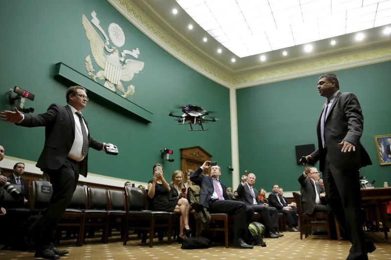
Time to Wake Up to a Growing Domestic Danger
A drone demonstration inside the U.S. Capitol, Washington, D.C., November 2015
On January 17, 2022, Houthi rebels in Yemen sent a group of armed drones on a journey of nearly 1,000 miles. Launched alongside ballistic missiles as part of a coordinated attack, the drones flew into the United Arab Emirates, a member of the Saudi-led coalition the Houthis are fighting. After passing above the Abu Dhabi skyline, some of the drones started a fire at the city’s airport. Others hit a group of oil trucks at a state-owned fuel depot, killing three people and injuring six.
The attack was just the latest reminder of the destructive efficiency of drones, which have become a weapon of choice for militaries, militias, and terrorists. But the strike on Abu Dhabi was also a reminder of something else: that the threat of drones is not confined to remote conflict zones; drones can also jeopardize the safety of those living in developed, seemingly safe cities. For the United States, where the civilian use of drones has grown exponentially, the implications of thousands of drones traversing the nation’s airspace are worrisome. Now that unmanned aerial vehicles are widely available, increasingly affordable, and easily adaptable, the drone threat is about to come home.
That threat is frustratingly multifaceted. Drones have been used in terrorist attacks, assassination attempts, and strikes on critical infrastructure. Like cyberattacks, they are hard to attribute. As the range and accuracy of drones have increased, they have essentially become a weapons delivery system—what one commentator has called a “cheap cruise missile.”
The looming domestic security threat posed by drones has been given far too little consideration by the U.S. government, which has left decisions largely to the Federal Aviation Administration (FAA) and to state governments, resulting in a patchwork of regulations, and neglected to build security into the basic design of the technology. With a threat as complex and dangerous as drones, Washington cannot afford to wait.
THE DRONE AGE
Drones have a distinctly military heritage. The United States first used them in the Vietnam War for reconnaissance. During the 1973 Yom Kippur War, the Israeli military deployed modified U.S. drones for surveillance and as decoys. Only around 2000 did the United States weaponize drones, adding Hellfire anti-tank missiles onto the Predator.
Over time, drones became essential weapons in the modern military arsenal. The United States has been a prominent user, relying heavily on them in its war on terrorism, but it is hardly alone. Today, by one count, 102 countries have active military drone programs. Some are powerful U.S. allies such as the United Kingdom, which conducted 398 drone strikes in Iraq and Syria between 2014 and 2019, whereas others are newer entrants: Azerbaijan, for example, used Turkish-made drones to tip the scales in its favor during its 2020 war with Armenia.
In Syria and Iraq, ISIS launched 60 to 100 drone attacks every month in 2017.
Nonstate actors have also come to rely on drones. Over the first nine months of 2021, Houthi rebels launched 33 missile and drone attacks against Saudi Arabia, many targeting critical infrastructure such as oil pipelines and tankers. Each drone costs the Houthis just a few hundred dollars. The Islamic State (also known as ISIS) had a significant drone program in Syria and Iraq, launching 60 to 100 drone attacks every month in 2017 alone.
In parallel, drones have exploded in popularity among civilians. According to the FAA, as of 2020 there were 1.4 million recreational drones and about 500,000 commercial drones registered in the United States. In a 2020 survey of Americans, eight percent of respondents reported owning a drone, and 15 percent reported having ever flown one. In the United States today, anyone over the age of 13 can buy and register a drone. The uses are diverse: not only can drones capture high-quality photographs and video, but they can also map terrain, monitor crops, forecast weather, and assist with search-and-rescue operations. In Cape Cod, beachgoers are even flying them to spot great white sharks. One market research group has put the value of the global drone market at nearly $30 billion.
Perhaps most revolutionary is the potential effect drones could have on shipping, deliveries, and transportation. In an effort to shorten arrival times, increase geographic coverage, and save money, Amazon, Google, and Uber have all invested heavily in drones that deliver orders. One research firm has predicted that by 2026, one million drones will be conducting commercial deliveries globally.
CHEAP AND EASY
For all the benefits of drones, their pervasiveness in everyday life poses significant security risks. For one thing, drones are easy to weaponize. Take the case of a Connecticut teenager who in 2015 posted videos of homemade drones he had altered to fire a semi-automatic handgun and shoot a flamethrower. Although off-the-shelf drones can generally carry only small payloads, this will soon change, and even today, some commercial drones can carry a 1,000-pound payload. Besides, even low-powered drones can deliver biological weapons or nuclear materials.
Another factor making drones so threatening is their ability to hover, which allows them to stay on target. It was this ability to have a persistent presence that initially made drones so essential for reconnaissance in warfare and for tracking the enemy, but it also makes them a potential privacy and security threat. Before the advent of readily available drones, reconnaissance required surreptitiously installing cameras, personally staking out a given location, or regularly flying over a target. Not so today. In 2017, a diesel-powered drone, the Vanilla Aircraft VA001, conducted a five-day continuous flight—landing with three days of fuel left to spare.
Other characteristics can also make drones dangerous. Drones are cheap and easy to make: in 2018, Syrian rebels fighting Russian forces strapped explosives to drones constructed from little more than a small engine, packing tape, plywood, and plastic. Drones are vulnerable to hacking and espionage as well, especially as their operating systems grow more sophisticated and remotely operable.
Even low-powered drones can deliver biological weapons or nuclear materials.
Finally, drones have a particularly destructive potential when enabled with artificial intelligence. Most salient is the danger from drone swarms: massive numbers of drones communicating and coordinating with one another using artificial intelligence to destroy a preprogrammed target. Drone swarms should be thought of as an emerging arms control challenge, as they are exceedingly difficult to counter or control. In 2020, a Chinese state-owned company released a video showing a Hummer-like vehicle that can launch a swarm of 48 drones, each carrying a high-explosive warhead. The next year, the Indian army staged a demonstration featuring a swarm of 75 drones, with plans to scale it up to 1,000 drones.
These attributes raise a number of risks for the U.S. homeland. The first and perhaps the most straightforward is the use of drones by terrorists and criminals, domestic or foreign, who might wish to transport contraband, attack a crowd, or assassinate a political leader. In 2015, a drone containing radioactive material landed on Japanese Prime Minister Shinzo Abe’s office. In 2018, a pair of drones exploded near Venezuelan President Nicolás Maduro while he was giving a speech outdoors. In November 2021, an explosives-laden drone landed on the residence of Iraqi Prime Minister Mustafa al-Kadhimi, injuring seven of his bodyguards.
Then there is the threat to critical infrastructure. For proof of concept, look no further than Saudi Arabia, where, in 2019, Iranian drones attacked two massive oil-processing facilities. The incident knocked out five percent of global oil supply overnight, causing the biggest sudden disruption in history. American infrastructure is also vulnerable. In 2020, a consumer drone that had been modified with a copper wire trailing behind it tried to land on an electrical substation in Pennsylvania—an attempt that, had it succeeded, could have caused a short circuit and taken down the electric grid. Between 2014 and 2019, there were at least 57 sightings of drones flying above domestic nuclear sites. The FAA receives more than 100 reports a month of drones flying around airports. In 2018, the United Kingdom’s Gatwick Airport shut down for 36 hours after drones were spotted in the sky nearby.
Last, the pervasive presence of drones can threaten Americans’ quality of life. They make a consistent and piercing buzzing noise that can become a constant annoyance; they also pose a physical risk from collision. Perhaps more acute are privacy concerns. In 2011, the Defense Advanced Research Projects Agency unveiled the AeroVironment Nano Hummingbird, a surveillance drone that is 6.5 inches long and lighter than a AA battery. Imagine the risks posed to personal privacy if this technology were adapted for civilian use: a nosy neighbor or a vindictive employer could spy on a person for days at a time, watching every aspect of one’s pattern of life.
READY FOR TAKEOFF
The current challenge from drones is reminiscent of the terrorist threat before 9/11. Drones are still in their infancy in terms of widespread adoption and technological evolution, and there is still time to address their risks, before losing control. If Washington waits, however, the costs of establishing adequate security measures and regulation will far exceed the costs of acting now. Delay also risks allowing the parties that have the most to gain from the mass proliferation of drones—namely, companies that make or intend to use drones—to dominate the rulemaking process.
To address the drone threat, the Biden administration should begin by issuing an executive order that establishes a senior interagency group—including representatives from the FAA, the Pentagon, the Office of the Director of National Intelligence, and the Department of Homeland Security (DHS)—to catalog drones’ security risks and come up with recommendations for mitigating them. Alternatively, the president could set up a public-private commission composed of government officials and industry leaders. In either case, the effort would be designed to counterbalance the legitimate commercial and economic imperatives of drones by focusing on the security side of the ledger.
Any solution should include strengthened public-private collaboration, whereby regulators work with drone manufacturers to build in security measures at the point of construction and provide greater oversight of drone operators. The good news is that the U.S. government has made progress in this direction over the past few years. In 2015, the FAA mandated the registration of all recreational drones, and drones are now required to include a “remote ID” that broadcasts the drone’s identity, location, velocity, and altitude. Three years later, Congress passed a law giving the DHS and the Department of Justice new powers to identify, track, and even shoot down threatening drones.
The challenge from drones is reminiscent of the terrorist threat before 9/11.
One important improvement has been proposed by Senator Chuck Schumer, Democrat of New York, and others: requiring that geofencing, technology that establishes virtual perimeters beyond which a drone cannot fly, be built into every drone, and mandating penalties for disabling the capability. The system could be informed by a government database containing the coordinates of sensitive areas, from airports to power plants. Although geofencing technology exists today and is built into many drone models, it is not required, and users can turn it off.
To protect critical infrastructure, the U.S. government should build what the analyst Zak Kallenborn has called a “national counter-drone network.” As he has argued, this could entail a system of bases at various critical sites across the country, each with defenses that would include remotely operated drones that can take down other drones. Such a network wouldn’t be cheap, but the costs would pale in comparison to those of a successful attack.
Policymakers also need to rethink who regulates drones. Today, the FAA serves as the primary regulator; it is worth considering whether more oversight power might be granted to the DHS. After all, drones originated as military tools. They should fundamentally be treated and regulated as potential weapons or instruments of surveillance, rather than as recreational or commercial objects. To that end, the DHS could be tasked with establishing the counter-drone network, for example, or with coordinating the installation of mandatory geofencing targets in every drone.
Last, the federal government needs a uniform approach to addressing privacy concerns related to drones. To date, the FAA has refrained from acting in this area, leaving regulation to a messy patchwork of state and local laws. California, for example, has passed a law aimed at the paparazzi that bars drone operators from flying over private property and capturing pictures and video, whereas Alabama has no laws specifically related to drone privacy. Although some federal legislation has been introduced, the issue remains unresolved. Congress should pass a law creating uniform standards to protect all Americans from being spied on by commercial or government drones.
NO TIME TO WASTE
The U.S. government’s failure to address the security implications of an emerging technology recalls the mistake it made with the Internet during its infancy in the 1970s and 1980s. Back then, the architects of that network traded encryption and privacy for nimbleness and growth—an error the country is paying the price for today.
Looking back, Steve Crocker, one of the engineers who worked on the design of the Internet, regretted not taking security into consideration. “We could have done more,” he said, “and most of what we did was in response to issues as opposed to in anticipation of issues.”
Drones have the potential to revolutionize life for the better, offering everything from faster deliveries to more efficient farming to smarter weather forecasts. To preserve those benefits while mitigating the costs, Washington needs to take a fundamentally different approach: anticipating the many dangers from drones, rather than responding to them as they arise. Otherwise, as with the Internet, it risks losing control.
By Tom Donilon
The United Arab Emirates (UAE) decided over the weekend to ban the use of recreational drones and light sports aircraft following recent attacks at an oil facility and airport.
As The Verge reports, the ban was confirmed by the UAE Ministry of Interior on Saturday, explaining the decision was made due to "the misuse spotted recently, not limiting the practice of these sports to the areas identified in the user permits and trespassing into areas where these types of activities are prohibited." The ban came into force on Sunday.
The misuse, according to APNews, involved Yemen's Houthi rebels targeting an oil facility in Abu Dhabi using explosives attached to drones. The attack managed to set three transport tankers on fire, killed three men, and injured six more people. A second drone attack occurred at Abu Dhabi International Airport and resulted in a fire, but "no significant damage."
The US is now working with the UAE on a reponse to the attack, with US National Security Advisor Jake Sullivan stating, "we stand beside our Emirati partners against all threats to their territory." Meanwhile, UN Secretary-General Antonio Guterres said the attacks carried out at the two locations were, "prohibited by international law," but is keen for the situation not to escalate.
By Matthew Humphries
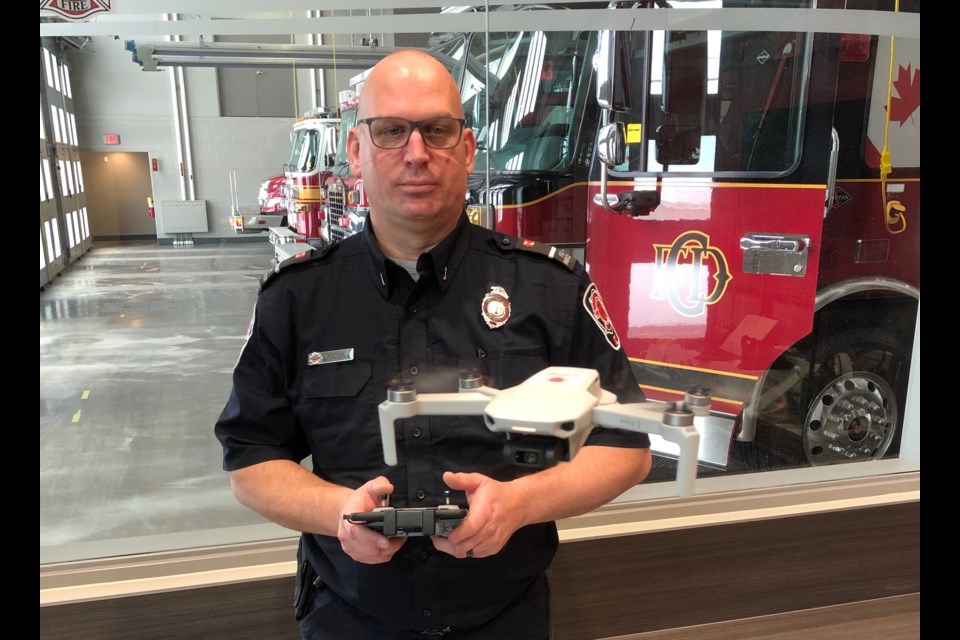
One of the latest recruits to the Collingwood Fire Department can fly over tall buildings, but it’s not a plane or a bird.
The fire prevention staff have added a 249-gram quadcopter drone to their truck to assist with rooftop inspections.
Fire Prevention Inspector Jeff Gage said he uses the drone to reach hard-to-access rooftops for commercial inspections.
Used for outdoor portions of the inspections only, the drone can survey a roof top and get in close for photos of any ventilation or units mounted on the roof. Before the DJI Mini drone became part of the fire department tool box, that would have to be done manually by a person on the ceiling.
Gage said he would sometimes have to ask the fire suppression crew to bring a ladder truck to the site so he could get on the roof for an inspection.
“The biggest thing for us is the health and safety implications,” said Gage. “Not having to access rooftops [in-person] is a plus. Anytime we don’t do that, it’s safer.”
With less dependence on the availability of a ladder truck, which could be called away to a fire, Gage can do more inspections and on his own schedule.
He said it’s a very useful tool for smaller fire departments.
“With few human resources to draw on, if one person can do an entire job safely, that’s the route to go,” he said.
There may be times when photos from the drone will show some red flags requiring an in-person inspection, but the drone photos will also give a more clear picture of what is on top of a roof before Gage or other fire prevention staff have to go up there.
“This helps us understand what’s going on, and rooftops we wouldn’t be able to access normally, we’ll be able to look at,” said Gage.
Outside of rooftop inspections, Gage said they used the drone to pinpoint the location of suspicious barrels dumped in a field. Photos from the drone also help the fire crews identify any materials contained in the barrels.
The tech is readily available in publicly accessible drones. The exact drone can be purchased at Best Buy for about $800. Gage said the drone has already paid for itself because of saving time and resources for the department.
The drone is controlled via smartphone. Gage can put his phone into the controller adapter, plan a route, and send the drone on its way.
The drone is a fairweather tool only, but that works for inspections, which are not emergency situations.
The prevention drone technically makes a fleet for the Collingwood Fire Department, since they have one other drone that’s been in use since late 2019.
The first drone came to the fire department after a rather dramatic rescue of a deer on an ice flow off the shore of Sunset Point.
The concerned citizen who called in the deer in distress was moved by the Collingwood Fire Department’s work to rescue it (with help from The Blue Mountains Fire Department and their Zodiac boat). The citizen made a donation to the Collingwood Fire Department toward a rescue boat of their own as well as for a drone and the training required for each member of the fire department to get licenced to fly it.
Used for the suppression and rescue side of the fire department’s work, the first drone, a Mavic 2 Enterprise, is equipped with an infra-red camera, a regular camera, and attachments such as a spotlight and speaker that can play a recorded message.
The larger of the two drones is also tougher, and can be sent up to capture aerial shots during a structure fire.
Photos from above a fire can help the crew get more information about what’s going on and get a more complete 360 view of the situation.
After the fire is under control, the thermal imaging camera can be used to locate hot spots that have potential to flare up again.
Fast spreading grass fires can be hard for firefighters to size up from the ground. A drone can zoom into the air above it to capture a photo of its spread.
“Start to finish it helps,” said Deputy Fire Chief Dan Thurman. “It’s another tool in the toolbox, another option to help fight the situation.”
Beyond fighting fires, Thurman said the Mavic drone can be used on almost any call.
In a search and rescue situation, fire crews can record a message to let someone know help is on the way and they should stay put. The message can be played through the drone’s speaker as it speeds through a forest trail, or along the ice over Georgian Bay.
Thermal imaging from the infrared camera can also allow the fire department to more quickly locate a person who is stranded on a trail or in the water.
For a hazardous materials call, the drone can be sent in to get photos of any warning labels or spills to give firefighters a better indication of what materials are involved in a spill or fire. They can stand a safe distance away while the drone sends back high-resolution photographs.
The Mavic and all its accessories cost about $3,500 plus the certification (about $1,000 per person).
As a self-proclaimed tech nerd, Gage said he’s excited about the future of drone technology applied to fire suppression, rescue and prevention.
“The technology coming is incredible,” said Gage. “There are drones that will leave the station and fly ahead of the fire truck to the call.”
In the meantime, he’ll be bringing the mini drone to his commercial inspections and keeping up to date on the latest applications for drone tech in the fire prevention field.
By Erika Engel , Collingwood Today
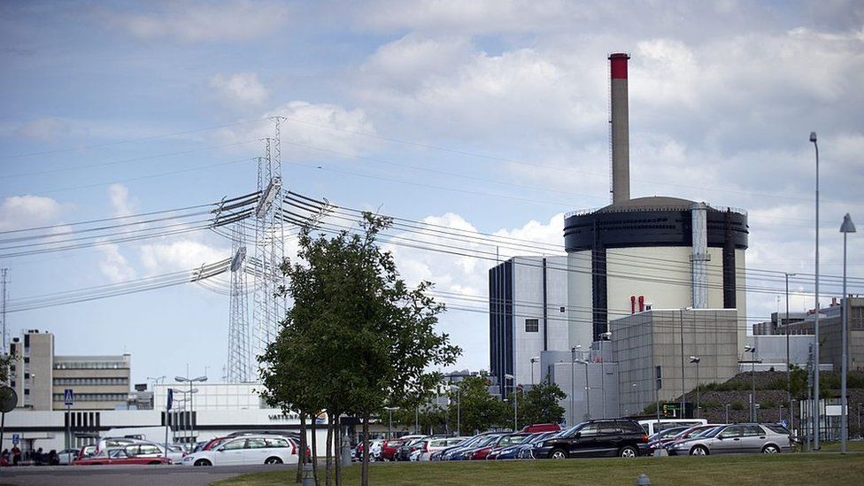
Days of sightings of drones over key Swedish sites including nuclear plants have prompted the country's security service to take the lead in an investigation.
Three nuclear sites have been targeted and sightings have been reported over airports and the royal palace.
Authorities have not speculated on who is behind the mysterious drones.
Police and the coastguard are searching the sea and islands around Stockholm, local media reports say.
The latest sightings on Monday evening involved a drone above the Forsmark nuclear plant, but security agency Sapo said it was also investigating earlier drone flights near the Ringhals and Oskarshamn power plants. Police appealed to the public to come forward with information.
Sapo said the drones were suspected of "grave unauthorised dealing with secret information".
BBC NEWS
"The security service is conducting the investigation regarding the drone flights over our nuclear plants. Regarding other drone observations it's so far a matter for the police," Sapo official Fredrik Hultgren told the BBC.
He refused to give details about the type of drone, but they have been widely described as military-style and as having large wings.
Swedish TV reported that a police helicopter was following a drone flying above it at a height of up to 1,000m (3,280ft) to the south-west and north-west of the capital Stockholm.
According to the Aftonbladet news site, a drone was seen over the weekend circling the parliament and government buildings, as well as the royal palace in Stockholm. Drones were earlier spotted near Kiruna and Lulea airports.
Prosecutors are keeping an open mind over who is behind the drone flights. They come at a time of increased military alert in Sweden because of tensions between Russia and the West over the Russian military build-up near the borders of Ukraine.
Sweden has recently deployed troops to the Baltic island of Gotland in what officials describe as a signal that Sweden's military forces are ready to defend their territory.
Sweden is not a member of the Nato defence alliance but said it was responding to three Russian landing craft moving into the Baltic Sea through Denmark's Great Belt Strait.
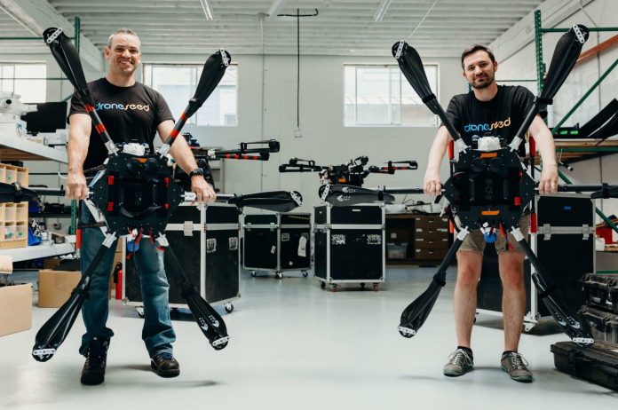
DroneSeed today announced it has raised $36 million in its Series A funding round. The round was led by Social Capital and Seven Seven Six, with participation from new and existing investors. Part of these funds were used to acquire Silvaseed, a 130-year-old forestry company, to expand DroneSeed’s seed collection and seedling cultivation services.
A pioneer in climate tech and post-wildfire reforestation, DroneSeed is the only company approved by the FAA to deploy a fleet of heavy-lift drones to reforest after wildfires, enabling healthy forests to grow back. This year, wildfires across the U.S. have already burned nearly six million acres of land, demonstrating the growing need for a full suite of vertically integrated reforestation services like those DroneSeed offers.
DroneSeed can drop seed vessels within 30 days after a fire, compared to traditional methods which can take years of waiting to replant. After it reforests burned land, DroneSeed sells the resulting carbon credits to organizations looking to go carbon neutral or negative.
“Global reforestation is key to our fight against climate change,” said Jay Zaveri, a partner at Social Capital. “We’ve supported DroneSeed from the very beginning given its promise to terraform our planet for good. Since then, DroneSeed has scaled its effort to reforest land, found a profitable model through carbon markets, and transformed the experience of forest development for landowners.”
“DroneSeed is using technology to restore forests faster and help save our planet. Their team’s mission-driven approach is what made this investment and partnership a natural fit for Seven Seven Six,” said Katelin Holloway, Founding Partner at Seven Seven Six who is joining the board as an observer. “DroneSeed has recruited fantastic talent from diverse communities and disciplines, and we are thrilled to support them as they take on an incredibly important global challenge: climate change.”
DroneSeed has expanded Silvaseed, which grows millions of trees per year, to become the largest private seed bank west of Colorado. The acquisition positions DroneSeed as a one-stop-shop for reforestation services including seed collection, seedling cultivation, aerial drone-based seeding, and financing with carbon credits. DroneSeed plans to further expand, doubling its capacity to address increased demand for reforestation services by the middle of next year.
“Recent data has shown that natural forest regeneration is in significant decline due to the size and severity of fires which destroy seed sources. Fire season is expected to only get worse because of climate change,” said DroneSeed CEO, Grant Canary. “This funding round, coupled with the acquisition of Silvaseed, enables us to scale up the infrastructure needed for reforestation to meet this skyrocketing demand and customer need. That starts with seed.”
In addition to acquiring Silvaseed to expand its seed supply, DroneSeed will use this funding to respond to the 2021 fire season already underway, adding on more reforestation projects, generating carbon credits, and expanding its services geographically in the future.
Along with Social Capital and Seven Seven Six, new investors in this raise include DBL Partners, which was an early investor in Tesla and SpaceX; Tobi Lütke, CEO of Shopify; Resilience Reserve; and Marc Benioff’s TIME Ventures. Existing investor Spero Ventures also participated with Marc Tarpenning, the co-founder of Tesla, continuing his role as a board observer. More than 60 per cent of the capital invested in the round came from investors with a climate and impact fund focus.
Additional investors and syndicates include Gaingels with Flight.vc, HBS Lady Angels, Julia Lipton’s Awesome People Ventures, and the Coalition angels including Ashley Mayer. Four of nine angel list syndicates are LGBTQ+ or female-led. This round includes continued participation from prior investors Massive, Drone.vc, and Rob Ness Syndicate who have supported the company since DroneSeed completed Techstars Seattle in 2016.
About DroneSeed:
DroneSeed is scaling reforestation to mitigate the worst effects of climate change. The company is the first and only FAA approved for heavy-lift drone swarms in all states west of Colorado. After its recent acquisition of Silvaseed, DroneSeed is now the first vertically integrated reforestation company in the industry and one of the largest private seed suppliers in the nation. The company is actively developing projects in California, Washington, Oregon, Idaho, Colorado, British Columbia, and Hawaii. DroneSeed’s current reforestation customer projects include tribal nations, three of five of the largest timber companies, nonprofits such as The Nature Conservancy, government agencies, and family forests. For more information, visit https://droneseed.com/
By PRESS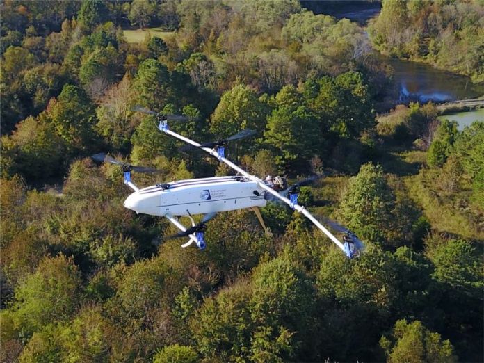
Picture this: A person is lost in the desert. Local first responders initiate a search and rescue operation. As they conduct the search, they’re faced with a problem: loss of broadband signal.
This isn’t a made-up scenario. First responders often work in conditions where communication networks are weak or not available. One possible solution is to use drones to deploy broadband networks, making signals available anywhere. But today’s drones often can’t provide adequate support to first responders. The equipment is too heavy for drones to carry for very long.
To help solve the largest challenges facing the first responder community, NIST often turns to private companies, academic researchers, hobbyists, and others via open innovation prize challenges. This time, the First Responder Unmanned Aircraft System (UAS) Endurance Challenge addressed the obstacle of extending the flight time for drones that carry heavy payloads. The objective for challenge participants was to design, build and fly a UAS that could carry a 10-pound (4.5-kilogram) communications device to deploy broadband coverage for as long as possible to transfer critical data files to the first responders. And as part of the challenge, participants were tasked with overcoming difficult technical requirements including weight restrictions, vertical takeoff and landing, an ignition kill system, and an appropriate fuel system, all while ensuring cost-effectiveness.
Forty-three teams entered the competition, of which five final competitors spent a total of 14 months designing and building lightweight drones that go beyond today’s technical capabilities by flying continuously for 90 minutes or longer with heavy payloads. The prize challenge competitors built their systems with the intention of providing broadband service to boots-on-the-ground first responders when they lack network or bandwidth. This includes servicing areas with a lack of cellular network coverage or where cellular infrastructure has been compromised due to a natural disaster, or areas with limited backhaul connectivity, which links the main network to remote locations.
Investing in Ingenuity: The Winning Competitors
The competition’s top prize went to Team Advanced Aircraft Company (AAC), which received $100K for its six-rotor drone with propellers on each arm. AAC is a veteran-owned company based in Hampton, Virginia, that specializes in building American-made drones that enable longer flights through their hybrid-electric propulsion system. The company builds UAS devices that are quick to set up and easy to use for its customers, including members of the public safety community. Unlike some other prize challenge competitors, AAC’s drone is not a prototype but a product it currently is selling.
The other top teams in the competition included Team Intelligent Energy (IE), which received second place and $40K for its six-rotor drone with a hydrogen fuel system, long-endurance, and lifting capabilities. Team Autonomous Robotics Competition Club (ARCC), from Pennsylvania State University, took third place and received $20K for its multirotor, gas-electric hybrid drone. Team Endure Air also contributed to the UAS competition with its single-rotor helicopter drone.
In addition to the overall prizes, NIST awarded eight Best in Class awards, worth $5K each:
- Endurance: Team AAC had a flight time of 112 minutes and 17 seconds in the “Last Drone Standing” technical flight.
- Innovation: Team AAC received this award for addressing all stage four criteria, taking into account all drone specifications while maintaining a high regard for the public safety mission.
- Weight: Endure Air’s UAS was 29.93 pounds (13.58 kilograms), the lightest of the competition.
- Autonomy: Team ARCC received this award for the success of its preprogrammed flight paths, obstacle avoidance and automatic orbits.
- Ease of Use: Endure Air took only four minutes and 30 seconds to put its UAS into an operational state, from packaging to flight-ready.
- Cost-Effectiveness: Endure Air’s UAS costs less than $5,000 to build.
- First Responder Award: AAC and ARCC were both awarded for their successes in public-safety-focused areas such as responsiveness, special features, and unique design elements.
The solutions developed by the four winners will increase UAS duration, payload, transmission rate and total transmission distances. With these new capabilities, the public safety community and first responders will have access to the tools they need to help save lives in search and rescue situations. “It’s very challenging to build a drone to the required first responder specifications,” said Dereck Orr, chief of NIST’s Public Safety Communications Research division. “Given the circumstances and restrictions, 112 minutes of flight time is extremely impressive.”
NIST regularly uses prize challenges to solve public safety problems. These competitions result in lasting partnerships with companies and academia to leverage for future innovations. And these partnerships help NIST advance critical research and development efforts that create conditions for economic growth and opportunity in the public safety domain.
More information about the UAS Endurance Challenge winners and their drones can be found on the NIST website.
Three New Drone Competitions
The latest UAS prize challenge, the First Responder UAS Triple Challenge, is open now and accepting submissions through Sept. 30. This challenge, also known as UAS 3.0, comprises three separate competitions:
- Challenge 1 — FastFind: UAS Search Optimized
- Challenge 2 — LifeLink: Providing Mobile UAS Data Wherever Lives Are on the Line
- Challenge 3 — Shields Up! Securing Public Safety UAS Navigation & Control
UAS 3.0 will help first responders’ search and rescue missions by improving search capabilities in areas with dense foliage, increasing broadband connectivity to get critical data to first responders, and protecting systems from potential cyberattacks. To learn more about the competition and to enter, visit the UAS 3.0 website.
UAS 4.0 will also be launching soon, but we need your feedback! Are you a first responder or innovator? What UAS technology do you think needs improvement? What public safety problem needs solving? Let us know by writing to us at pscr@nist.gov.NIST PSCR UAS Endurance Challenge Final Results & Recap
The final results and a recap of NIST PSCR’s 2020 UAS Endurance Challenge competition.
By PRESS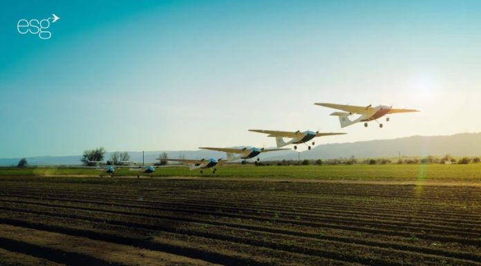
EmbraerX, the disruptive innovation arm of Embraer, and Pyka, an Oakland-based startup working at the forefront of autonomous aviation, today announced a partnership to accelerate the future of autonomous aerial agriculture operations.
The collaboration is focused on technology, certification, operations, and future commercialization of Pyka’s Pelican, a 100% electric and autonomous fixed-wing agricultural aircraft.
By using agile experimentation processes, the companies will work together to accelerate the entry of Pyka’s best-in-class autonomous solutions into service in the precision agriculture sector.
EmbraerX is committed to exploring disruptive products and services that could revolutionize the business, including new market segments for Embraer’s agriculture aviation business.
“EmbraerX is a market accelerator committed to developing solutions that can transform the world and inspire our partners by approaching unprecedented ideas with creativity and grit,” said Daniel Moczydlower, head of EmbraerX.
“Pyka’s innovation and technology capacity is aligned with our strategy to accelerate the creation of innovative business models through partnerships that have the potential for exponential growth.”
Both companies will pursue opportunities to scale commercial services as autonomous aircraft operations in Brazil evolve in the coming years. Pyka’s Pelican is already flying for customers in Central America, aiming for a high level of productivity, cost-efficiency, safety and sustainability.
“We’re incredibly excited to team up with one of the world’s largest aerospace companies to enable our vision of bringing electric aircraft into everyday use,” said Michael Norcia, CEO and co-founder at Pyka.
“We’ve been laser-focused on certifying and delivering a compelling autonomous electric aircraft to serve customers. Now, we are working with an industry-leading aerospace partner in one of the largest agricultural markets in the world to help scale our electric aircraft business. We look forward to working with EmbraerX to further integrate autonomous electric aircraft into the agriculture industry and the broader economy.”
The partnership is backed by Embraer’s more than 50-year history in aircraft development, certification, manufacturing, commercialization and aftermarket services expertise.
About EmbraerX
EmbraerX is a market accelerator committed to developing solutions that transform life’s experiences. This Embraer S.A. disruptive innovation subsidiary is based on Florida’s Space Coast in Melbourne, integrated with the Company’s engineering team in Brazil, and dedicated to collaborating with global innovation communities.
The EmbraerX team of innovators, creators, thought-leaders, and designers combines human-centred design thinking with business-building and engineering expertise to tackle some of the biggest mobility problems facing humanity today. For more information, visit EmbraerX.com About Pyka Pyka is building the future of electric aviation. Pyka’s has developed the world’s first and only commercially certified 100% electric autonomous airplane.
Pyka’s aircraft have flown over 3,000 autonomous agricultural aviation missions – one of the most complex and difficult environments for any aircraft to navigate. Pyka’s proprietary technology includes autonomous flight control software, flight computers, high energy density batteries, high power density motor controllers, and certifiable carbon fiber composite airframes to enable 100% electric aircraft.
The company is headquartered in Oakland, CA.
To learn more, please visit www.flypyka.com
By PRESS