Site blog
Canada’s air navigation service provider, NAV CANADA, launched NAV Drone this week. Designed to help drone pilots and operators safely and legally fly their remotely piloted aircraft systems (RPAS) in Canada, NAV Drone is now available on the Apple App Store and Google Play Store. A web version of NAV Drone is also available on NAV CANADA’s website.
From June to December 2020, NAV CANADA received nearly 16,000 RPAS flight authorization requests, a 54 percent increase over the same period in 2019, and this trend is expected to continue as a growing number of companies and individuals find new uses for drones in Canada.
As Canada’s air navigation service provider, NAV CANADA has an essential role to play in developing an operating environment that supports the innovative potential of the drone industry and ensures safety across Canadian airspace.
NAV Drone enables users to submit drone flight authorization requests from a mobile device and provides information to help users fly drones quickly, safely and legally in Canada’s controlled airspace.
The only app that can provide drone pilots and operators with permission to fly in NAV CANADA controlled airspace, NAV Drone has an intuitive user interface that allows users to:
- gain awareness to better understand Canada’s airspace;
- visualize where basic and advanced drone pilots can fly;
- create an operation, update and manage drone flights; and
- obtain automatic authorizations from NAV CANADA when approved to fly.
This system makes the process of requesting authorization to fly in controlled airspace easier and faster for qualified drone pilots and operators.
Quote
“NAV Drone is creating a safer Canadian airspace for all. The drone industry and demands on NAV CANADA’s services are evolving rapidly, so we are continuing to innovate to meet the needs of drone pilots and operators today and well into the future. The new app is a key component of our national drone strategy and will further our dedication to air traffic safety and technological innovation in Canadian airspace.”
— Mark Cooper, Vice President, Chief Technology and Information Officer, NAV CANADA
About NAV CANADA
NAV CANADA is a private, not-for-profit company, established in 1996, providing air traffic control, airport advisory services, weather briefings and aeronautical information services for more than 18 million square kilometres of Canadian domestic and international airspace. The Company is internationally recognized for its safety record, and technology innovation. Air traffic management systems developed by NAV CANADA are used by air navigation service providers in countries worldwide.
By PRESS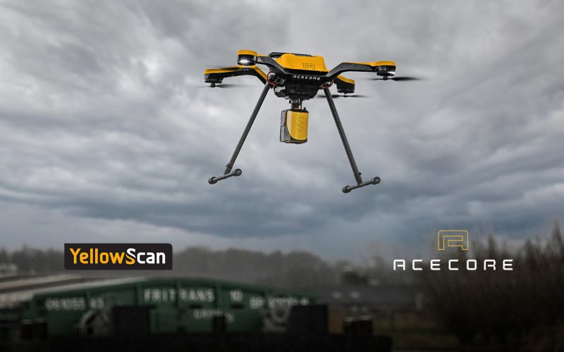
Montpellier, France and Uden, Netherlands – June 2nd, 2021 – YellowScan, a global leader and designer of next generation of Unmanned Aerial Vehicles (UAV) LiDAR solutions, announces a new product collaboration with Acecore Technologies the developer and manufacturer of professional grade UAVs for data collection and surveillance markets. This marks the first time that the two companies have come together to offer the market a completely integrated LiDAR/Drone solution configured to work together.
Unlike other YellowScan solutions, the YellowScan Mapper is a purely aerial LiDAR solution that is ideally flown at 70m above ground level. Although it is designed to fit most professional drones and comes with an integrated camera module, we have worked with Acecore to configure Mapper to take full advantage of the Zoe platform. YellowScan Mapper is ideal for general topography projects and is particularly suited for civil engineering, powerline, forestry and archeology missions. The YellowScan Mapper seamlessly integrates with existing YellowScan software solutions, LiveStation and CloudStation, making it easy to live stream your pointcloud data while the system is flying, and comprehensively post-process, visualize and export survey data right after your flight.
The Acecore Zoe is a highly versatile quadcopter, designed to perform in any circumstance. The hand-made carbon fiber drone will carry the YellowScan Mapper with its RGB camera module for 28 minutes continuously, taking only 90 seconds to ascend to 70 meters AGL and initialize the YellowScan Mapper’s IMU. The optional laser guided terrain following mode keeps Zoe at a constant height, ensuring a quality output throughout the survey area.
“Seeking partnership with YellowScan makes a lot of sense for us, it enables us to supply the worldwide market with true end-to-end LiDAR mapping solutions with an unmatched level of support and after sales service.” said Jorrit Linders, founder and CEO of Acecore Technologies
“Despite the fact that the Mapper is designed to be agnostic to the UAV it is mounted on, the opportunity that Acecore gave us to make sure that their Zoe drone and our Mapper LiDAR solution worked seamlessly together was a chance we could not pass up. Both companies have been around for a long time and that know how translates into a user experience that is second to none”, stated Tristan Allouis, CTO, YellowScan.
For more details on this combined offering including pricing and full list of configuration options please contact Acecore Technologies or YellowScan.
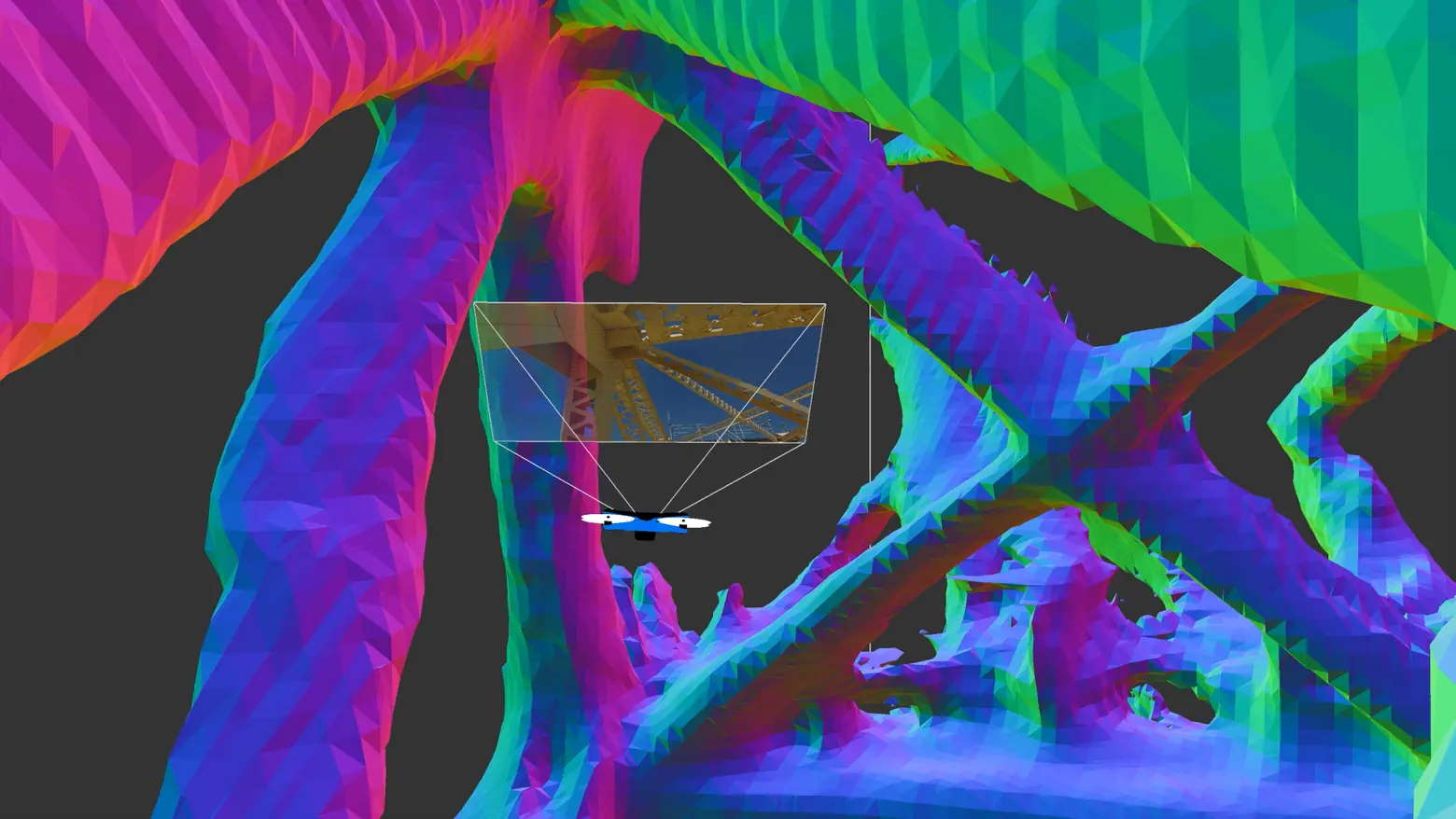
Skydio, the leading U.S. drone manufacturer and world leader in autonomous flight technology, today announced the general availability of its adaptive scanning software, Skydio 3D Scan™. 3D Scan extends Skydio’s groundbreaking autonomous flight engine with advanced artificial intelligence (AI) skills that automate photographic data collection and mapping tasks ranging from infrastructure asset inspection to crime and accident scene reconstruction. In addition, Skydio announced that Bentley Systems, the infrastructure engineering software company, has joined DroneDeploy and RealityCapture in Skydio’s technology partner ecosystem as a preferred photogrammetry solution for 3D Scan datasets. Skydio will provide a closer look at 3D Scan during a special online broadcast event from the U.S. Space and Rocket Center in Huntsville, Alabama today at 9 a.m. PT.
3D Scan makes inspection jobs up to 75% faster
Traditional asset inspections performed by workers using bucket trucks, ropes, and ladders are dangerous, time consuming, inaccurate, and often damaging for the environment. Drones have emerged as a valuable tool to conduct visual inspections and gather critical data without putting operators at risk. Drone inspections can generate useful datasets without putting inspectors at risk. But the complexity, crash risk, and training costs of manual drones have greatly limited their ability to generate useful data. These capture workflows are especially critical as the industry transitions from providing inspection reports consisting of handwritten notes and photographs of structures to fully immersive, annotated 3D models that enable measurements and continuous status tracking. Manual drones require cumbersome mission planning, constant access to GPS, and intense focus from an elite pilot to avoid collisions–when inspection teams should be focused on how to capture the best data instead.
3D Scan automates data capture for asset inspection and scene reconstruction, allowing any inspector, surveyor, or first responder to efficiently capture a complete photographic dataset that documents every angle of a scene, ensuring accurate coverage with sub-millimeter precision in a fraction of the time while greatly reducing risk. This revolutionary technology ushers in a new age of autonomous inspection. Specifically, 3D Scan will improve:
- Rapid Field Assessment. Generates photosets in minutes and enables intelligent photo browsing in the field for real-time inspection and decision-making.
- Digital Twin Generation. Provides data for 3D models of key assets and scenes that can enable up-to-date status tracking and integration in VR, game engines, and cultural heritage sites.
- Inspection Reporting. Inspections performed by Drone Service Providers can standardize to the highest standard of quality and coverage.
- Crime and Accident Scene Reconstruction. More rapid and complete documentation clears scenes faster while generating complete virtual records.
“We are extremely excited about the value that 3D Scan delivers. Manual drones lack the ability to see and understand the 3D nature of the world and, as a result, can’t provide a scalable solution to replace traditional methods of inspection. With 3D Scan we are turning Skydio drones into intelligent scanning robots that can build real-time flight plans optimized to each scene, and generate the best possible photographic datasets.” – Hayk Martiros, VP of Autonomy, Skydio
3D Scan is adaptive mapping software that extends Skydio’s flight autonomy engine to generate tailored inspection flight paths in real time for digitization of any asset or scene. The technology comes to market battle-tested after months of trials with leading organizations, including Sundt Construction, North Carolina Department of Transportation (NCDOT), and the Boston Police Department. Early access participants have reported up to 75% faster data capture, 50% greater inspection team output, and 30% lower reinspection rates (needing to refly the structure due to incomplete data on the first attempt) during the trial period.
“We have been amazed by the results we achieved using 3D Scan during the Early Access Program. Our teams will be able to get in the field faster and better serve our clients through the business development, operations, and close-out processes.” – Dean Miller, Virtual Construction Engineer, Sundt Construction
First responders will soon be able to store and manage chain of custody for their 3D Scan datasets using Skydio’s integration with Axon Evidence.com . This workflow gives public safety operators new tools for presenting full evidence of crime and accident scenes.
3D Scan is available for Skydio 2 now, with Skydio X2 availability coming soon. The software can be purchased as an optional add-on to any Skydio 2, starting at $2,999 per drone per year, or as part of new vehicle and software bundles.
Bentley Systems joins Skydio’s technology partner ecosystem as a preferred partner for photogrammetry
Skydio 3D Scan datasets can be used to generate 3D models through a growing ecosystem of 3D reconstruction engines, including Dronedeploy, RealityCapture, Bentley’s ContextCapture. The high-quality and accurate imagery from Skydio 3D Scan generates better 3D models than current manual drone workflows, which limit the performance of reconstruction engines.
“We are excited to partner with Skydio to help our users safely, reliably, and repeatedly generate the photo datasets required to create amazing 3D models and digital twins. Infrastructure assets like roads and bridges, rail and transit systems, utilities, and buildings and industrial facilities are very complicated and capturing them accurately and precisely is hard to do manually. Combining the Skydio drone automation with the high-performance and highly scalable 3D reconstruction capabilities of Bentley’s ContextCapture will enable our users to create great models, more frequently, and more cost effectively than before.” – Robert Mankowski, SVP of Digital Cities at Bentley
3D Scan Launch Event Details and Registration
Skydio has shared some of the unprecedented results that beta customers have achieved, garnering praise from drone industry publications. At today’s event, Skydio CEO, Adam Bry, will share additional details about 3D Scan and the company’s vision for autonomous drone inspection. Details about the event and registration can be found here.
About Skydio
Skydio is the leading U.S. drone manufacturer and world leader in autonomous flight. Skydio leverages breakthrough AI to create the world’s most intelligent flying machines for use by consumers, enterprises, and government customers. Founded in 2014, Skydio is made up of leading experts in AI, robotics, cameras, and electric vehicles from top companies, research labs, and universities from around the world. Skydio designs, assembles, and supports its products in the U.S. from its headquarters in Redwood City, CA, to offer the highest standards of supply chain and manufacturing security. Skydio is trusted by leading enterprises across a wide range of industry sectors and is backed by top investors and strategic partners including Andreessen Horowitz, Levitate Capital, Next47, IVP, Playground, and NVIDIA.
About Bentley Systems
Bentley Systems (Nasdaq: BSY) is the infrastructure engineering software company. We provide innovative software to advance the world’s infrastructure – sustaining both the global economy and environment. Our industry-leading software solutions are used by professionals, and organizations of every size, for the design, construction, and operations of roads and bridges, rail and transit, water and wastewater, public works and utilities, buildings and campuses, and industrial facilities. Our offerings include MicroStation-based applications for modeling and simulation, ProjectWise for project delivery, AssetWise for asset and network performance, and the iTwin platform for infrastructure digital twins. Bentley Systems employs more than 4,000 colleagues and generates annual revenues of more than $800 million, in 172 countries.
By PRESS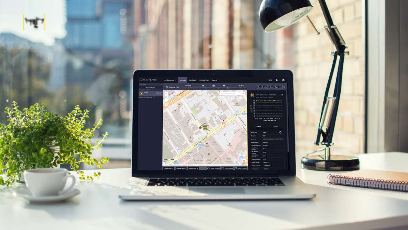
SAN LUIS OBISPO, Calif., 2021, WhiteFox, the global leader in airspace security, has launched STRATUS, the world’s first cloud-based system to detect and track drones. WhiteFox has adapted its core technology that stops drones from operating unsafely or illegally, such as smuggling drugs into prisons and surveilling nuclear power
plants.
STRATUS is available in a cloud-based application, enabling every industry to benefit from drone detection technology. Within 24 hours of launching, STRATUS has already been featured on FOX Business News and named the #1 Drone Detection System by Airwards.
While drones offer many benefits for the commercial industry, in the wrong hands, they are equally dangerous.
The U.S. federal government has repeatedly warned that the risk of a drone attack is steadily increasing in the U.S. due to drones’ widespread availability and ease of use. Small drones have been used to smuggle drugs into prisons, attempt the assassination of Venezuelan President Nicolas Maduro, drop explosives on U.S. soldiers, commit corporate espionage, and shut down airports— costing airlines $64M in a single shutdown. Tim Bennett, who oversees counter-drone technologies at the Department of Homeland Security told NBC News, “One of the biggest problems is that we don’t have a true understanding of the complete air picture.” Traditionally to detect drones, expensive equipment would have to be installed at each facility that required protection.
However, STRATUS instantly creates a virtual bubble of protection to track drones and perform risk assessment in real-time. The system enables users to define geofences and notification criteria. Users can track, report, and log drone activity as it occurs with instant text or email notification. Users can also access historical drone traffic over their facilities and produce reports showing exactly what has happened.
WhiteFox sensors provide coverage in major metropolitan cities across North America. Customers simply need a computer or phone connected to the Internet to use STRATUS and instantly track drones intruding in their airspace.
As the future of drones is developing, WhiteFox provides this solution as an accessible way to make drone flight information available to increase the safety and security of our airspace.
“STRATUS is a giant leap towards trusted autonomy. But in the wrong hands, drones can fly with near impunity— doing whatever they want with those on the ground often helpless to stop a reckless or malicious drone. WhiteFox envisions a future where drones benefit our lives much like cars. Many drones are authorized and provide substantial benefits to society. But just as when a car breaks the law, people can see that, and the proper authorities can respond. STRATUS is the first-ever technology to create that kind of transparency and accountability of drone activity. After thousands of hours of customer feedback and testing, we are proud to
publicly launch the technology that will save lives and help unlock the immense potential of the commercial industry.” says WhiteFox Founder and CEO Luke Fox.
For customers who have the legal authority to mitigate drones, STRATUS can be paired with other WhiteFox products to provide to enable the safe, surgical mitigation of dangerous drones by safely landing them. As more and more drones fill the skies, knowing where drones are operating and what they are doing will lead to more
responsible and beneficial drone use.
From celebrities and business executives in Los Angeles to data centers in the South to skyscrapers in New York City, STRATUS is now providing drone airspace security real-time, coast to coast.
About WhiteFox: WhiteFox is the global leader in drone airspace security. Pioneering drones’ safe integration into society and unlocking the commercial drone industry, WhiteFox’s internationally award-winning, scalable solutions protect nuclear power plants, royalty, celebrities, international airports, Fortune 100 companies, data centers, prisons, and venues around the world from reckless and malicious drones.
By PRESS
World’s first remotely operated offshore search and rescue service is among 38 robotics and automation projects receiving £7 million of government investment.
UK offshore wind workers could soon be kept safe using a remotely operated search and rescue service, thanks to a pioneering project backed by £7 million of government support.
This project is one of 38 business-led projects which will receive funding to accelerate their robotics and AI technologies as part of a drive to build back better from the coronavirus (COVID-19) pandemic.
Science Minister Amanda Solloway announced the winning projects, which include a paint applicator robot and a healthcare drone pad control centre, today (Tuesday 25 May) at the 2021 Robotics and Artificial Intelligence Industry Showcase.
Located across the UK, the projects will help to transform key UK industries and sectors – from life sciences to offshore energy – by making them safer and more productive. The funding forms part of the government’s commitment to invest in ground-breaking research and raise economy-wide investment in research and development to 2.4% by 2027.
Science Minister Amanda Solloway said:
We are throwing our weight behind the most transformative technologies because innovation is at the very core of our plans to build back better from the pandemic, drive productivity and grow the economy.
From a first of its kind automated rescue service for UK offshore energy workers, to drone technology delivering for our NHS, these robotics technologies could be game changing as part of our continued efforts to tackle global challenges – from pandemic preparedness to climate change – all while cementing the UK’s status as a science superpower.
Offshore Survival Systems in Edinburgh is being backed to develop a first of its kind search and rescue service which will use a network of semi-autonomous unmanned rescue vessels (URVs) to save lives at sea. It will be aimed primarily at supporting UK workers in the offshore energy industry who must deal with increased wind speeds and wave heights, while working far from shore.
Digital & Future Technologies, an electronics firm in Colchester, Essex, will also receive funding to help NHS and healthcare workers to tackle COVID-19 and future pandemics. The business will be building an automated drone system which will load and unload its own cargo, ensuring that vital healthcare equipment such as personal protective equipment (PPE) can be delivered to UK hospitals at speed and without the need for human assistance.
Meanwhile, University of Liverpool spin-out Mobotix will use its funding to develop an automated ‘back-up lab’, which can be operated remotely. This lab will mean that pioneering research can be done during periods of lockdown or social distancing, without risk of infection. The project will help build operational resilience for the UK’s leading life sciences laboratories so that they can maintain the scientific excellence demonstrated in combating COVID-19 over the past year.
Andrew Tyrer, Challenge Director for the Robots for a Safer World challenge, said:
The funding is crucial to widening the scope of our work and reach out to innovative designers not captured by our previous competitions. With net zero ambitions underlying industrial plans in every sector, and the chance to rebuild new industries after the pandemic, robotics, AI and automation are vital ingredients for the future.
Other projects receiving grant funding include:
- Motion Robotics in Southampton, developing a smart drone pad control centre to deal with a future increase in levels of drone transport for healthcare. The control centre will help coordinate drone flights between hospitals and suppliers or laboratories, ensuring a smooth and uninterrupted supply chain
- Crover Ltd, an Edinburgh based technology company developing the world’s first small robotic device that can ‘swim’ through grains stored in bulk, for example wheat and barley, highlighting their condition and identifying grain spoilage. This will enable farmers to intervene at an early stage, reduce wastage and protect their revenues
- HausBots Limited, a Birmingham based small and medium-sized enterprise (SME), developing a wall-climbing robot that paints and protects walls from damp. Painting is the 5th most dangerous job in the UK, with painters at risk of accidents and health conditions, including repetitive strain injury. This project aims to deliver safety and productivity to painters, contractors and clients, in a cost-effective way
The investment is being delivered through UK Research and Innovation’s flagship Robots for a Safer World Challenge, a £112 million programme to develop research and innovation in advanced robotics and autonomous systems.
By PRESS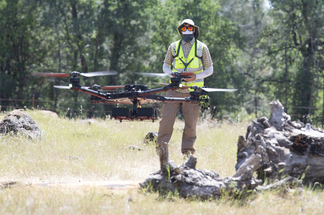
Helping make the battle against wildfires faster, safer, and more targeted, a NASA project recently tested its tools in a realistic wildland firefighting exercise. The Scalable Traffic Management for Emergency Response Operations project, or STEReO, aims to create a system that can be deployed during emergencies to coordinate multiple elements of disaster response. These may include aircraft, teams on the ground, and data collected from the air. Pictured here is NASA drone pilot Jonas Jonsson, flying an uncrewed aircraft during a flight demonstration in Redding, California, on May 5, 2021. STEReO’s partners at the California Department of Forestry and Fire Protection, or CAL FIRE, and the U.S. Forest Service flew wildfire-fighting aircraft in coordination with NASA drones like this one, using STEReO’s system to keep all parties informed of the ongoing operations.
Dialogue with the wildfire management community continued on May 13, with a workshop hosted by NASA’s Aeronautics Research Mission Directorate, in collaboration with the Space Technology and Science Mission Directorates. More than 150 attendees worked to identify specific challenges facing stakeholders, from prediction and detection of wildfire, to mitigation and remediation efforts after a fire. Participants identified the need for persistent surveillance of wildfire-prone areas, a common operating picture for all responders, and near real-time data streams in support of actions. Better coordination and data sharing across all levels of government, along with artificial intelligence and machine learning tools, were also considered necessary to the effort. This input will inform potential NASA contributions and collaborations to improve the state of the art in wildfire management.
The workshop followed and built upon a meeting of the Tactical Fire Remote Sensing Advisory Committee, a group composed of the larger wildfire management community that aims to prioritize development of technologies to fill information gaps. The NASA event attracted a diverse group involved in wildfire management, including government organizations, such as the U.S. Air Force, U.S. Forest Service, U.S. Geological Survey, National Guard, and CAL FIRE, the firefighter community, industry, and academia.
Editor: Abigail Tabor
By
Gary Mortimer

Kyiv – For the first time in Ukraine, agricultural drones developed by leading global robotics & AI company XAG was recorded the highest level of spray drone performance. As Ukraine becomes the second largest grain exporter, XAG has actively introduced drone and ground robot into this emerging agricultural superpower, which helps smooth its transition to autonomous farming.
Since hitting the Ukraine market at the end of 2020, XAG Agricultural Drones have been rapidly scaling up to help Ukrainian farmers reap better harvest and reduce chemical usage. Ukraine holds soft regulation over spray drones flying over the fields, which makes it become one of the favourable markets in Europe to embrace large-scale agricultural drone use.
XAG has collaborated with DroneUA, one of the top 20 innovative companies in Ukraine, to distribute its agricultural drones and robots that can sow seeds, spray crops, and spread fertilisers. It is anticipated that this would tap the under-equipped agricultural sector of Ukraine which plays a key role in fulfilling the increasing global food demand.
Promising tools for the fertile black soil
In cooperation with Agro-Region, one of Ukraine’s largest agricultural holdings, the DroneUA team hosted a practical demonstration this April to evaluate the effectiveness of XAG Agricultural Drones on winter barley fields near the village of Velyka Oleksandrivka, Kyiv region.
The test showed that one XAG drone, when equipped with atomised sprayers and a 20L smart liquid tank, could operate at an efficiency of over 16 hectares per hour. The result was confirmed by the Ukrainian Club of Agriculture Business (UCAB), setting a record high spraying performance of drones on the real world of farm work in Ukraine.
In particular, one operator, along with two outside observers, controlled three XAG Agricultural Drones to apply crop protection products on the swarm flight mode. 43 hectares of barley were treated fully autonomously by this small fleet of drones in 53 minutes. They are more precise and flexible than the large trailed and self-propelled tractors, which means that drones can get into hard-to-reach areas, reduce the use of pesticides and avoid mechanical damage on crops.

Operator switched battery and liquid tank
The demonstration greatly changes the perception or attitude of people in Ukraine towards agricultural drones now as an innovative and promising sprayer equipment. “I have never evaluated drone as an industrial tool for spraying. But after this test which shows strong productivity, the introduction of agricultural drones has been hugely rationalised,” said by Volodymyr Kravtsov, Operational Director of Agro-Region.
Under the intensive farming model, many Ukrainian farmers and agribusinesses still rely on outdated farm machinery that has restricted the potential of production and export. However, there is a prospect of boom in agricultural automation technologies for Ukraine, which sets out to become a worldwide breadbasket. According to International Trade Administration, the operational need for agricultural machinery and equipment of Ukraine is estimated at $20 billion by 2025.

Autonomous drone spraying operations for winter barley
Through better equipping the agricultural sector and closing the yield gap, XAG autonomous technologies that feature drones and robots could bring a new round of transformation. The rich black soil of Ukraine, which accounts for 25% of the global reserve, nourishes the world’s major grain crops such as corn, barley and wheat.
According to its Ministry of Economic Development, Trade and Agriculture, Ukraine has ranked second among the world’s grain exporter in 2020 with an overall grain exports amounted to 55.09 million tons. As the main contributor to global food security, Ukraine is witnessing a huge potential of grain production to be furthered explored.
Scale-up for smallholders and young blood
In 2020, the Ukrainian Government has adopted a new land reform law that puts an end to the moratorium on the sale of arable land. Over the past twenty years, farmers and agricultural businesses can only grow crops depending on land leases. But starting in July 2021, agricultural land will be available for sale to Ukrainian citizens. This will encourage farmers to increase their grain planting areas and invest in innovative agricultural machinery and infrastructure.

Bringing young people back to agriculture
While Ukraine is about to embrace the opening of the land market, both financing policy and education program are also implemented to scale up the use of drones in agriculture. Under the support of DroneUA, XAG drones become the first agricultural drone that can be leased with full insurance coverage in Ukraine.
It makes drones more affordable to smallholders who can now gain access to new technology. Smallholders generate nearly 45% of the country’s gross agricultural output, undoubtedly being the backbone of adequate food supply.
In addition, as autonomous farms are just over the horizon, XAG is expected to see a new influx of young people who would manage the fields with these smart devices. According to Valerii Iakovenko, Co-founder of DroneUA, in his partnership with the National University of Life and Environmental Sciences of Ukraine (NULES), new courses on unmanned spraying solutions will be introduced to teach bachelor students the use of XAG Agricultural Drone. The aim is to train young talents for the next generation farming.
Following a series of successful demonstrations, XAG’s autonomous drones have been available across major dealers in Ukraine and gain momentum to empower more farmers. As Ukraine being one of the major global markets, XAG will keep working with local businesses and government to improve its agricultural productivity for the Zero Hunger Goal.
bY press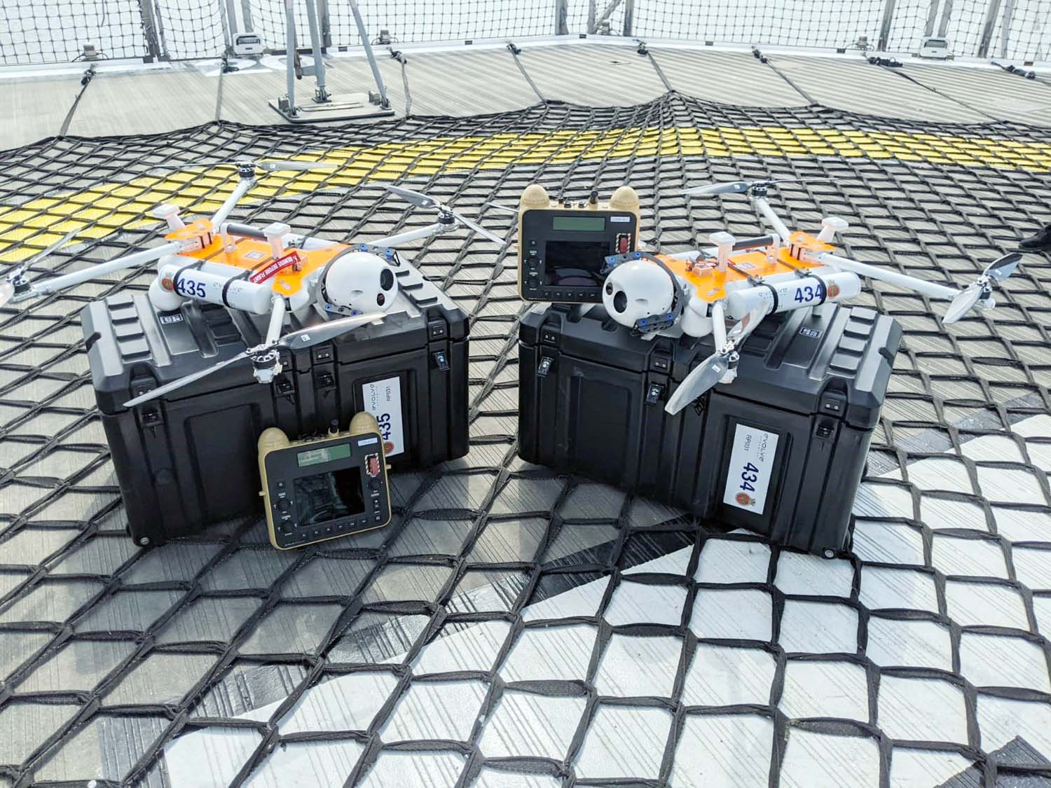
Drones will soar over the frozen wastes of Antarctica – and help guide the Navy’s sole polar research ship safely through packs of ice.
HMS Protector has been assigned two small rotary wing drones, specially adapted for her unique mission in the polar extremes.
Although the Devonport-based survey ship has a large flight deck, with no hangar she cannot take helicopters with her – unlike her predecessor HMS Endurance, which carried two Lynx.
The two small Sky Mantis Remotely-Piloted Aerial Vehicles from Surrey firm Evolve Dynamics have been given the same numbers as the (long-retired) Lynxes 434 and 435.
They can operate in sub-zero temperatures for up to an hour at a time, sending high-definition video (including 30x zoom and infrared imaging) back to their operators – all members of Protector’s 48-strong ship’s company.
They were trained by the Royal Navy’s sole drone squadron, 700X, based at Culdrose near Helston, then continued to train with the 7.6kg drones at HMS Raleigh in Torpoint, much closer to the icebreaker’s home.
The main mission for the two small aircraft will be scouting for ‘ice leads’.
“When operating in the ice we will always look for the path of least resistance, as this reduces the long term strain on the engines and hull,” said survey specialist/hydrographer Lieutenant Adelaide Banyard.
“It is very easy to ‘chase a lead’, an area with less-concentrated ice, but that might not actually take in the direction we want to.”
Instead, the drones will be launched to find the ice leads and the positions/locations will then be inputted into the navigation system and the team can work out the best compromise route.
The ship also plans to use the drones to provide ‘overwatch’ – providing additional safety for sailors as they carry out fishery boarding operations on behalf of the Foreign Office and Commission for the Conservation of Antarctic Marine Living Resources, or looking out for teams put ashore by scouring the area for dangerous animals.
And there’s also the potential for using the drones in the aftermath of a disaster, to gather information about the area affected and allow the sailors and Royal Marines to determine where or who to help first.
“This is an amazing piece of kit to be working with,” said Protector’s First Lieutenant and senior drone operator Lieutenant Commander Robbie Nash.
“We have been continually learning with this system as we are the first Royal Navy ship to have its own remotely-piloted aerial system. Hopefully we have demonstrated a viable route for other units to source and develop their own drone capability.”
Survey specialist Able Seaman Joe Cochran is one of the sailors itching to test the small aircraft over the ice and snow.
“The Royal Navy has provided me with various training courses with 700X Squadron based at Culdrose, but flying the Sky Mantis is far superior to anything I have flown before,” he added.
“We are yet to fly it at sea and look forward to doing so, and deploying while in the ice to test the amazing cameras that are fitted.”
His ship is currently undergoing Operational Sea Training ahead of her return to the ice following the most extensive refit/maintenance period in her history.
Hopefully, we have demonstrated a viable route for other units to source and develop their own drone capability.
Lieutenant Commander Robbie Nash
By PRESS
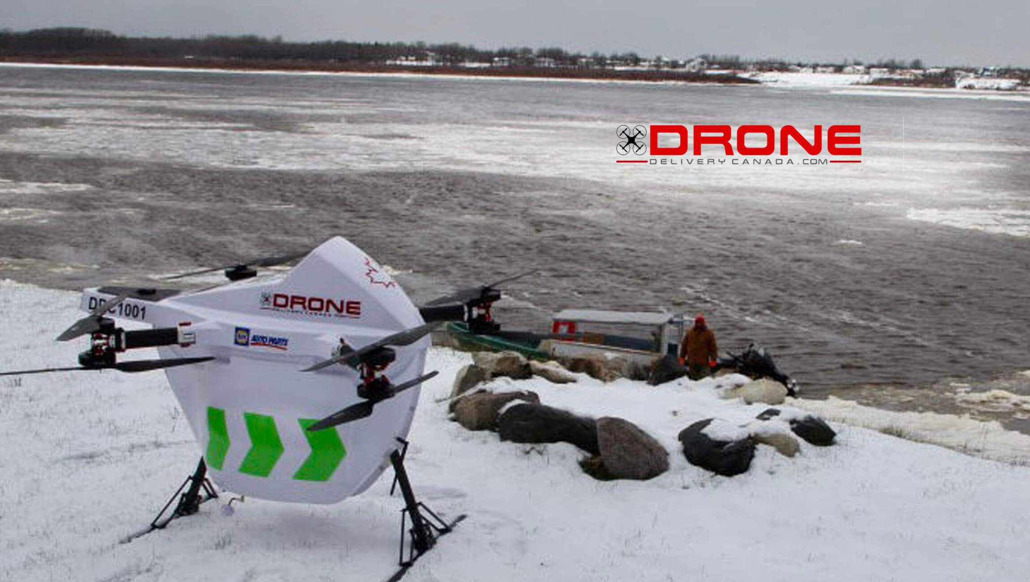
Drone Delivery Canada Corp. (TSXV: FLT) (OTC QX: TAKOF) (Frankfurt: A2AMGZ) or (Frankfurt: ABB.F) (the “Company” or “DDC”) is pleased to announce that, with the assistance of its sales agent Air Canada (TSX: AC), it has been selected by the University of British Columbia (“UBC”) to deploy DDC’s patented drone delivery solution at the Stellat’en First Nation, for UBC’s “Remote Communities Drone Transport Initiative” program.
The project will enable defined-route deliveries utilizing DDC’s Sparrow drone and its DroneSpot® takeoff and landing zones as well as additional drone flight infrastructure as required. The solution will be used to transport a variety of cargo for the benefit of the Stellat’en First Nation, located in the Fraser Lake area of Central Northern British Columbia, Canada.
DDC and UBC will work towards finalizing a definitive agreement shortly. DDC is expected to commence deployment of site infrastructure summer of 2021 and expects to begin providing drone delivery services under the agreement in the second half of 2021. The drone project term is expected to be 12 months. This deployment will be DDC’s fourth First Nations project and its first in British Columbia.
All operations will be conducted in accordance with appropriate Canadian regulations. Flights will be remotely monitored by DDC from its Operations Control Centre located in Vaughan, Ontario.
“We look forward to working with Drone Delivery Canada and all partners on this project for the benefit of the Stellat’en First Nation. Many First Nations communities in B.C. are on lockdown to reduce transmission of COVID-19, which has exacerbated inequitable access to health care supplies and services, ranging from personal protective equipment and medications to laboratory services such as COVID-19 testing and diagnostics for other medical conditions,” said Dr. Michael Allard, Vice-Dean, Health Engagement & Partnerships, UBC.
“Based on the isolated location of our community and the needs of our residents, drone transport may enhance our access to COVID-19 testing and medication without traveling and endangering other members of our community,” said Chief Robert Michell of the Stellat’en First Nation, located about 100 kilometres west of Prince George. “The futuristic potential of this initiative is exciting. With drone technology, there is so much you can do.”
“We are pleased that UBC has chosen Drone Delivery Canada as part of their ‘Remote Communities Drone Transportation Initiative’ at the Stellat’en First Nation. The UBC Faculty of Medicine is a recognized global leader and we applaud their initiative to embrace drone delivery to benefit First Nations communities. As an award-winning global leader, DDC is pleased with our continued business successes in the drone delivery industry,” said Michael Zahra, President & CEO of DDC.
About UBC’s Drone Transport Initiative
For more information, please see: https://www.med.ubc.ca/news/ubc-receives-750k-td-ready-challenge-grant-to-deliver-health-care-supplies-by-drone-to-remote-b-c/
About the University of British Columbia
For more information, please see: https://www.ubc.ca
About Stellat’en First Nation
For more information, please see: https://www.stellaten.ca
About Drone Delivery Canada Corp.
Drone Delivery Canada Corp. is an ISO 9001 certified, award-winning drone technology company focused on the design, development, and implementation of its proprietary logistics software platform, using drones. The Company’s platform is used as a Software as a Service (SaaS) model for government and corporate organizations globally.
Drone Delivery Canada Corp. is a publicly listed company trading on the TSX.V Exchange under the symbol FLT, on the U.S. OTC QX market under the symbol TAKOF and on the Frankfurt exchange in Germany under the symbol A2AMGZ or ABB.F .
Read more at: www.DroneDeliveryCanada.com
By PRESS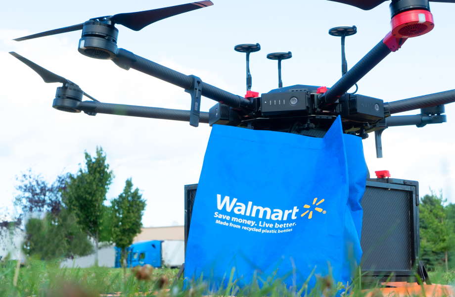
Flytrex, a leader in on-demand drone delivery for food and retail, today announced the expansion of its drone delivery service in Fayetteville, North Carolina, following approval by the Federal Aviation Administration (FAA). The newly granted waiver permits Flytrex to operate its drone system above people, allowing for the largest-scale backyard drone deliveries of goods known to date. Deliveries will be made in cooperation with long-time partner Causey Aviation Unmanned as part of the waiver, offering food, drinks and other goods to thousands of eligible households in the area who can opt-in to the service. Flytrex will conduct all flights within line of sight, maintaining the highest safety standards.
Households will be able to purchase a wide variety of goods from the neighborhood Walmart store as well as local restaurants and cafes. Orders are placed using the Flytrex app, which updates customers regarding their order status along the route until the package is lowered by wire safely into their backyard.
“The FAA approval is important to expanding on-demand drone delivery throughout the US in compliance with the highest possible safety standards,” said Yariv Bash, Co-Founder and CEO of Flytrex. “Through this expansion, we will be able to glean valuable insight into usage and customer preferences, allowing us to further tailor our offering to meet consumer needs. With the ongoing help of the FAA, drone delivery will soon become the rule rather than the exception.”
In September 2020, a benchmark pilot project between Flytrex and Walmart was announced to bring backyard drone delivery to Fayetteville. The pilot is aimed at exploring how drones can deliver items from the Walmart store to customers in a way that’s convenient, fast and safe – from picking and packing to takeoff and arrival. The expansion will enable a larger number of homes to enjoy the on-demand drone delivery service in Fayetteville, NC.
“Flytrex shares our passion and commitment to bringing the immense benefits of unmanned aerial delivery to the public, responsibly and safely,” said Jeff Causey, Founder and CEO of Causey Aviation Unmanned. “We are thrilled to announce this benchmark approval with them, and to continue providing swift and safe deliveries to an expanding number of households in North Carolina, and beyond.”
Flytrex participated in the Federal Aviation Administration’s UAS Integration Pilot Program (IPP) from 2018 to 2020, and chose to continue with the FAA’s subsequent initiative, BEYOND, to work with the North Carolina Department of Transportation (NCDOT) as well as the Kansas Department of Transportation (KDOT) and the North Dakota Department of Transportation (NDDOT) to help tackle the remaining challenges of UAS integration.
“Being First in Flight, North Carolina is renowned for its contribution to aviation history. Today, we continue that illustrious record by contributing to unmanned aviation history,” said Bobby Walston, NCDOT’s Aviation Director. “In working with our UAS partners over the past several years, we’ve seen the impressive advances these companies have made spearheading on-demand drone delivery in the US, and this latest groundbreaking approval is another milestone in that journey.”
About Flytrex
Flytrex is ushering in a new era of on-demand delivery. Flytrex provides a direct-to-consumer autonomous drone delivery service that lets retailers and quick-service restaurants (QSRs) cater to a wider customer base with faster, safer and cheaper on-demand deliveries than ever before.
From setting new drone safety standards to helping advance regulations to meeting the ever-evolving needs of retailers and consumers alike, Flytrex is bringing about a future of simpler, quicker, and greener autonomous airborne delivery. Headquartered in Tel Aviv, the Flytrex team has 50+ years aerospace and defense experience.