Site blog
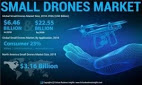
The market for small drones is projected to reach $22.55 billion by the end of 2026, according to a report recently released by Fortune Business Insights. In a paid analysis study titled “Small Drones Market Size, Share & Industry Analysis, by Type (Fixed-Wing, Rotary-Wing, and Hybrid/Transitional), By Power Source (Lithium-ion cells, Hybrid Fuel cells, and Solar cells), By Size (Micro, and Mini & Nano), By Application (Civil & Commercial, Military, Homeland Security, and Consumer) and Regional Forecast, 2015-2026” researchers predict that the 2018 $6.48 billion market will grow by 15.92% during the forecast period, 2019 to 2026. The report also states that North America is the largest market globally for small drones; but the fastest growth rate will be in the Asia Pacific region.
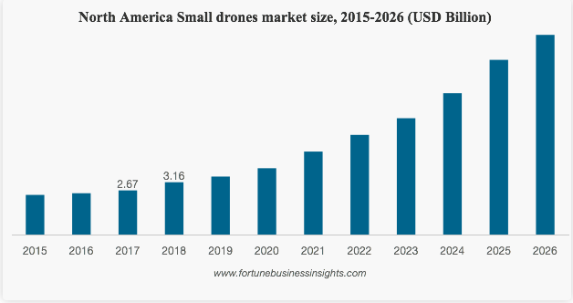
While actual numbers are always open to interpretation, growth curves are interesting to look at for trends. This research provides more evidence that the best is yet to come for the U.S. drone industry: far from slowing down, the market is likely to grow exponentially. Looking at the chart here, the real volume won’t come next year or the year after – but for companies who use the time to develop their products and customer base, the real payoff is on its way.
Fortune Business Insights says that the military market – especially Homeland Security – is a significant market driver now. Border patrol and combat troops are increasingly using small drones commercially available: military technology is increasingly crossing over to the enterprise markets. The civil and commercial market, however, will be the leading sector driving future growth. Disaster management, the power industry, and drone delivery are among the future market drivers.
The report also points out the opportunity that the small drones market represents for the manufacturers of improved batteries and other innovative power sources to increase the endurance of small drones.
By: Harry McNabb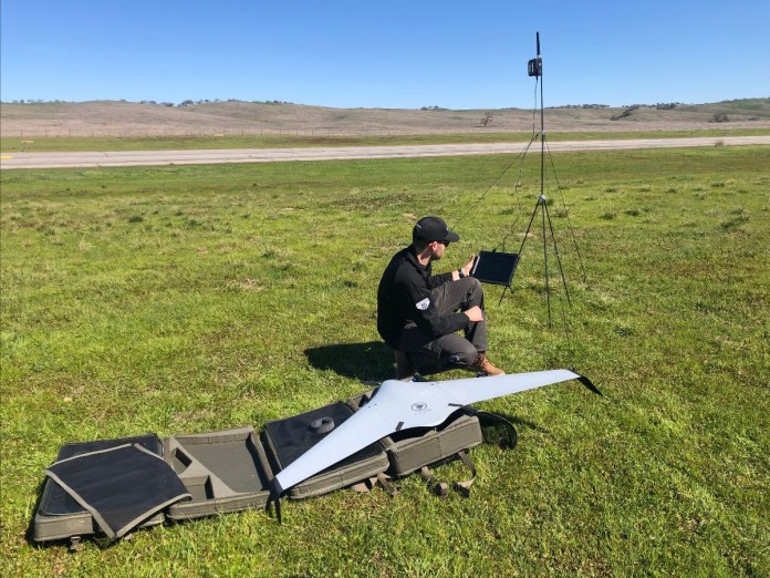
An Intelligence, Surveillance, and Reconnaissance (ISR) sUAS drone developed by Terra Drone group company C-Astral was tested and flown during EOTACS 2020
Slovenia/Tokyo – March 13, 2020 – ATLAS C4EYE, a fixed-wing mini tactical drone developed by Terra Drone member company C-Astral Aerospace, has successfully completed the 2020 Expeditionary Organic Tactical Airborne ISR Capability Set (EOTACS) evaluation conducted by the US Special Operations Command (USSOCOM).
C-Astral’s US-based distributor, Planet Inhouse, demonstrated the capabilities of the ATLAS C4EYE sUAS to USSOCOM observers from Feb 24 to Feb 27, 2020. These observers included experts from combat development directorates as well as operators from the Marine Corps Forces Special Operations Command (MARSOC), US Army Special Operations Command (USASOC), and the Naval Special Warfare Command (NSWC-WARCOM).
The ATLAS C4EYE team completed the final reconnaissance scenario without any technical malfunctions and without being detected by the observing red force units. The team also successfully demonstrated night operations, ‘Cursor On Target’ functionality with on-the-fly annotations of the points of interest and targets, full interoperability, and blue force tracking capability. The evaluations were led by the Naval Postgraduate School (NPS) teams and took place on and from the McMillan Airfield on the Camp Roberts Army National Guard Base in central California.
he ATLAS C4EYE successfully cleared the following EOTACS evaluation parameters:
- Cyber Assessment: Conducted by the Joint Vulnerability Assessment Branch (JVAB) and consisting of assessments of the overall UAS, data exfiltration, RF/cyber, onboard data storage, and forensics.
- Acoustic Assessment: Completed by NPS researchers. The acoustic assessments created wave files for each platform, which were then analyzed for time series, spectrogram and frequency spectrum.
- Ground Assessment: Performed by an NPS data collection team to verify the manufacturer’s UAS specific dimensions and logistics information.
- Flight Performance Assessment: Consisted of vehicle flight performance assessments completed by the NPS data collection team during day and night flying and ‘real world’ scenario operations.
As per the USSOCOM requirements, all EOTACS drones should be capable of providing Intelligence, Surveillance and Reconnaissance (ISR) data to Special Operations Forces during both day and night operations and under adverse environmental conditions. The ATLAS C4EYE met all the requirements and demonstrated its platform specifications.
The mature system is ready to be integrated into active Special Operations units, law enforcement, firefighting as well as non-governmental ecological monitoring tasks. For this purpose, Planet Inhouse has chosen Milwaukee, Wis.-based Menet Aero, a Service-Disabled Veteran-Owned Small Business (SDVOSB) as the training partner for ATLAS C4EYE operators within the US.
With a vision to solidify US market presence with manufacturing, training and support capabilities, C-Astral and Planet Inhouse are already in discussions for further system capability demonstrations throughout the United States.
As a system that has been designed in an allied NATO country (Slovenia) by a small enterprise with market presence in more than 60 countries, the ATLAS C4EYE and the entire C-Astral Aerospace family of unmanned systems are well-positioned to replace the current NATO and US sUAS legacy systems with secure, upgraded, open, and interoperable drones at an affordable acquisition price.
By PRESS
Draganfly Inc. (CSE: DFLY) (OTCQB: DFLYF) (FSE: 3U8) (“Draganfly” or the “Company”), an award-winning, industry-leading manufacturer within the commercial Unmanned Aerial Vehicle (“UAV”), Remotely Piloted Aircraft Systems (“RPAS”), and unmanned vehicle sector, today announced they have been selected by Windfall Geotek (TSX-V: WIN) and have entered into a letter of intent with Windfall Geotek (the “LOI”), to help develop an Artificial Intelligence (“AI”) driven unmanned aerial systems (“UAS”) solution for landmine detection in the defense, humanitarian, and other sectors which the companies have expertise in.
Windfall Geotek has been a data services company and a leader in the use of AI and advanced knowledge-extraction techniques since 2005. The terms of the LOI include Windfall Geotek contracting Draganfly to conduct research, development and engineering support of hardware that can interface with Windfall’s AI software.
The purpose of the LOI is to further commercialize Windfall Geotek’s AI driven solution for the detection and elimination of Land Mines, Unexploded Ordinance, and Improvised Explosive devices via the use of UAS. Governments and Non-profits allocated nearly US$700 million in combined international and national support for mine action in 2018 and the economic impact of landmines is estimated at $100 billion1. The closing of the transaction is subject to the parties achieving certain milestones prior to closing.
“We are extremely excited to be working with Draganfly to help enhance our core product offering. AI and machine learning together can transform how mining exploration is done. When you add to it Draganfly’s engineering expertise, their industry-leading products and technology we feel the possibilities in mining, oil and gas and military applications are endless,” said Dinesh Kandanchatha, Chairman of Windfall Geotek.
“Windfall Geotek has been in business for over 15 years and their leadership has a proven track record. We are excited to be working with their team on a commercialization strategy that uses Draganfly drones, technology and expertise.” said Cameron Chell, CEO of Draganfly.
About Windfall Geotek
Windfall Geotek (TSX-V: WIN) is the leader in the use of Artificial Intelligence (AI) and advanced knowledge-extraction techniques since 2005 in the mining sector. Windfall Geotek can count on a multidisciplinary team that includes professionals in geophysics, geology, Artificial Intelligence (AI), and mathematics. The Company’s objective is to develop a new royalty stream by significantly enhancing and participating in the exploration success rate of mining.
About Draganfly
Draganfly Inc. (CSE: DFLY; OTCQB: DFLYF; FSE: 3U8) is the creator of quality, cutting-edge, UVS and software that revolutionizes the way people do business. Recognized as being at the forefront of technology for over 21 years, Draganfly is an award-winning, industry-leading manufacturer within the commercial UAV and UVS space, serving the public safety, agriculture, industrial inspections and mapping and surveying markets. Draganfly is a company driven by passion, ingenuity and the need to provide efficient solutions and first-class services to its customers around the world with the goal of saving time, money and lives.
For more information on Draganfly, please visit us at www.draganfly.com
By PRESS
Impossible Aerospace has launched a product called Air Support that the company says will “forever transform the world’s cities and the way they respond to emergencies.”
Impossible Air Support, the company said, is a turn-key program that lets cities dispatch drones directly to the scene of their 911 calls to improve emergency response times.
Mounted on top of tall city buildings, the drones are controlled by police officers and firefighters from secure command stations within their departments.
Once deployed, they can provide a live video feed of an evolving situation to responders on the ground, intervene in a situation with sirens or lights, or even deliver crucial supplies like life jackets or AEDs.
While the company expects its drone technology to be controversial, founder Spencer Gore defended the idea of equipping cities with drone technology.
He said: “Each minute shaved off 911 response times is estimated to save 10,000 lives per year and the average response time today is almost 10 minutes. The right drone can respond in one minute.”
The company says it is now in ‘Phase One’ of its Air Support deployment, with several police and fire departments across the state of California now flying its US-1 aircraft.
Phase two, it says, will involve a series of hardware and software updates that enable cities to perform more advanced missions using their aircraft.
Gore continued: “The idea of chasing criminals using drones might sound and look a bit like Blade Runner, but it will undeniably save lives. On average, one person is killed every day in vehicle pursuits — often, innocent bystanders.”
Air Support drones will be equipped with sirens, spotlights and loudspeakers, the company said, so that first responders may use them to provide instructions from the air to emergency victims or suspects.
Impossible Aerospace says it takes pride in being an American drone manufacturer, with Gore stating “we design and assemble our aircraft all in one factory in the United States.”
by ALEX DOUGLAS
AUVSI has made a statement on this year’s XPONENTIAL 2020, declaring it plans to “proceed as scheduled.”
Commenting on its current position, AUVSI said it is closely monitoring the situation and assured everyone that health and safety was a top priority.
The statement reads: “We are closely monitoring the COVID-19 coronavirus situation and want to assure everyone that your health and safety are a top priority.
“We are in close communication with the Boston Convention and Exhibition Center, as well as related health, public safety and transportation authorities, to make sure that appropriate disease prevention, monitoring, and response protocols are in place for XPONENTIAL 2020.
“Based on currently available information from health authorities, our present plan is to proceed with XPONENTIAL 2020 as scheduled. If our assessment of the situation changes, based on new and evolving developments or updated information, we will promptly update this statement regarding the status of XPONENTIAL 2020 accordingly.”
It continued: “We recognize that restrictions on travel and other public health or governmental measures affecting high-risk regions will prevent some people from attending or exhibiting at XPONENTIAL.
“However, we look forward to most of you being able to travel safely and participate productively in this year’s XPONENTIAL.”
AUVSI then went on to outline the measures being taken by the host convention center in Boston.
Those measures include:
- Coordination with city, state, and federal first responders on current risk information and implementation of disease response protocols.
- Assigning medically trained public safety staff and medical first responders in the convention center, qualified to screen guests and identify high-risk illnesses.
- Deployment of additional hand washing signage and sanitation stations throughout the facility.
- Frequent cleaning of restrooms and public spaces by staff qualified on techniques to prevent transmission of sickness.
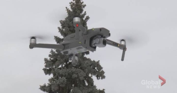
A new drone is expected to help the Peterborough Police Service with traffic investigations.
The service purchased the drone at the end of December 2019. According to Sgt. Ryan Wilson, the device will be primarily used for traffic purposes.
“Anytime we have a fatal collision or a serious bodily harm collision, we can use that to grab aerial photography,” he said. “We can use (the images) to give a point of view of what a driver might have been seeing at the time of a collision.
“Down the road, we might progress to using it for GPS measuring to free up some resources from shooting the actual measurements at a collision scene.”
Currently, Const. Matt Cumming is the only service member licensed to pilot the drone. Wilson said Cumming took extensive training to earn an advanced operation certificate from Transport Canada.
Cumming has been primarily practising flights with the drone, but it was used to assist in the removal of vehicles found in the Otonabee River in late December, Wilson said.“It’s definitely a piece of equipment you can use where there’s not necessarily an officer who could get that vantage point as this piece of equipment can,” he said.
Wilson says that currently, there are no plans to expand the service’s drone usage as police are still “getting our feet wet” with the new investigative tool.
The service paid just under $2,000 for the drone, Wilson said.
“When you think about the cost and some of the resources we might have to use otherwise, it’s not a bad investment on our part,” said Wilson.
 1:47OPP catch 2 Mississauga men trying to fly contraband into Collins Bay Institution in Kingston
BY GREG DAVIS

The new strain of coronavirus is our current natural disaster, and drones and other new technology are being used to respond.
As Covid-19’s first site of attack, China has led the battle against the Coronavirus, and it has turned to technology as a tool to help stop the spread of the disease. Currently, technology is being used to help identify those with a fever in an effort to help stem the spread of the disease. According to a recent BBC article, “advanced AI has been used to help diagnose the disease and accelerate the development of a vaccine…Alibaba, the Chinese e-commerce giant, claims its new AI-powered diagnosis system can identify coronavirus infections with 96% accuracy.” Separately, Alibaba founder Jack Ma has just announced that his charity, the Jack Ma Foundation, will donate over 2 million dollars toward the development of a vaccine.
Emerging technologies such as AI, facial recognition, thermal sensors, and drones are being used to help prevent the further spread of the disease in China. “In the battle against Covid-19, emerging technologies have stood out by making immense contributions in an unexpected, creative and amazingly responsive way,” said Lu Chuanying, a senior official at Shanghai-based Global Cyberspace Governance.
New technologies have helped “arrest or contain the spread of the deadly virus, thus becoming one of the most reliable and trustworthy means of combating Covid-19,” he wrote in an article for state-run China Daily newspaper.
Some of the ways that China is using technology to fight the virus probably won’t fly in the U.S. or other countries, however. Personal body temperature scanning has become widespread in public places – and in some places, through the windows of residents’ homes. Apps that anyone can download that inform you if anyone around is a risk for the virus might not be acceptable in other places: and police helmets that set off an alarm in case a fever is detected are unlikely to be implemented.
Disinfectant and Drone Delivery – Maybe. Body Scans Through Your Window? Maybe Not.
China has used modified crop-spraying drones to spray disinfectant over public areas in an attempt to kill the virus. And with more than 50 million people under quarantine in China, drone delivery has also been a critical tool. Drones have been used to deliver supplies to people in quarantined areas, so that they do not have to frequent stores and markets. While drones spraying disinfectant and drone delivery might be a good idea, both applications are heavily regulated in the U.S.: and regulators would need to grant special permissions.
Other drone uses may simply not be acceptable in other places – or even prove useful. A video on Chinese-language news site The Paper shows that one Chinese community is sending drones equipped with thermal sensors and loudspeakers to check the temperature of people inside of their apartments through the window. Through a speaker attached to the drone, officials ask residents to open the window and stand in front of it to have their temperature checked.
Alert! Someone Has a Fever
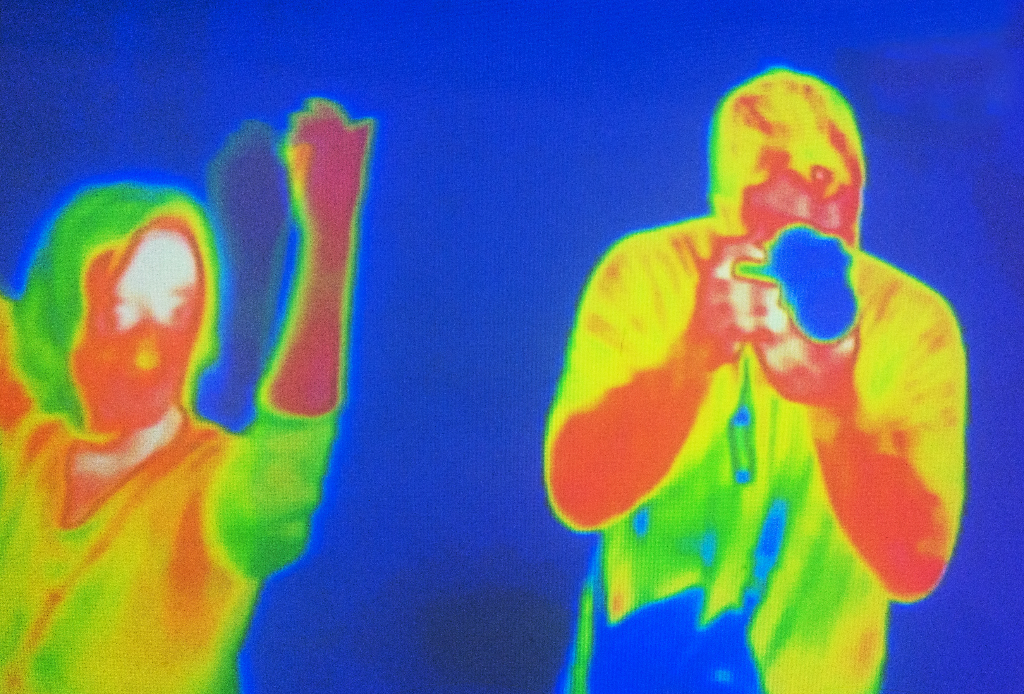
The disease can be difficult to track, in part because many people who may have the virus do not experience serious sypmtoms. One way that governments have attempted to track the spread of the disease is by monitoring body temperature of passers by in public places. SenseTime, a five year old Chinese based AI firm giant that sometime partners with US based Universities such as MIT, says its contactless temperature detection software has been deployed at underground stations, schools and community centers in Beijing, Shanghai and Shenzhen. Megvii, a Chinese technology company that designs image recognition and deep-learning software, has developed a similar temperature detection product which has also been deployed in Beijing.
“During this challenging time, we see this not as an opportunity, but our responsibility to do our part to tackle Covid-19 using our technology,” a SenseTime spokesperson told the BBC.
Chinese newspaper Global Times reports that officials in Chengdu city, Sichuan province, are using “smart helmets that can measure the temperature of anyone within a 5m radius, sounding an alarm if they are found to have a fever,” according to the BBC. And, as Chinese citizens slowly return to work despite the virus outbreak, mobile phones have also emerged as a key tool to track the spread of the coronavirus. An app called Alipay Health Code assigns individuals the colour green, yellow or red, depending on whether they should be allowed into public spaces or quarantined at home. The app has already been adopted in more than 200 Chinese cities.
Is this technology really of help, or is it all for show?
“The state media apparatus, even under normal circumstances, takes every opportunity to send a message about China’s technological sophistication, even if a story has little substance to it,” notes Elliott Zaagman, who covers China’s technology industry and co-hosts the China Tech-Investor podcast.
“I suspect that most of the stories we see about disinfecting robots, drones, etc, are mostly just performative gimmicks. However, tech’s ‘less-sexy’ role in controlling this outbreak should not be dismissed,” he told the BBC.
By: Miriam McNabb
Darmstadt, March 5, 2020 – Only three months after its initial funding, Corecam Capital Partners has increased its investment in Wingcopter in a second closing. In December, the multi-family office from Singapore participated in a seed round with several million euros in the German start-up, which develops and sells transport drones for humanitarian and civil applications.
The reason for the decision is the great commercial interest in Wingcopter. In the three months since Corecam’s first investment in December 2019, the startup has been able to achieve several milestones:
- In cooperation with Merck and the Frankfurt University of Applied Sciences, Wingcopter performed the world’s first beyond-visual-line-of-sight flight (BVLOS) between two production facilities. Laboratory samples were flown over a distance of 25 kilometers from the Merck plant in Gernsheim to the company’s headquarters in Darmstadt – over highways and state roads, power and rail lines, and industrial infrastructure (see TechCrunch article; ).
- As part of a humanitarian aid project in Malawi, 90 kg of medicines were delivered by Wingcopter to remote areas that were partially cut off from the outside world by a flood, adding up to a total of over 10,000 flown kilometres within a month just in that specific project.
- Following the successful participation in the African Drone Forum and the Lake Kivu Challenge in Rwanda, several African governments and international organizations have expressed their interest in cooperating with Wingcopter.
- Commercial partnerships have been concluded with several globally active companies (announcements to follow).
- Parallel to the above-mentioned successes, Wingcopter will exceed by far the turnover of the entire previous year already in the first half of the year.
Martin Lechner, Managing Partner of Corecam Capital Partners, commented: “The worldwide commercial interest in Wingcopter’s innovative and powerful eVTOL drones is impressive. Based on the very positive development in recent months, we are supporting Wingcopter in a second round of financing to enable the team to successfully implement their ambitious growth plans”.
“We are very proud that Corecam is convinced of our approach and that they have provided us with additional financial resources after such a short time. With the additional capital, we will continue to expand the team in order to be able to meet the high demand and to accelerate the further development of the Wingcopter”, adds Wingcopter’s CEO Tom Plümmer.
Philipp Weber, Venture Capital Partner at FPS Law and member of Wingcopter’s advisory board, adds: “In contrast to many other drone start-ups in the logistics sector, which currently only present prototypes and visions, Wingcopter has been able to impressively demonstrate the capabilities of the Wingcopter drone in flight operations in recent months, among other things through flights in aid projects. The further investment by Corecam is an important step towards rapid growth”.
Wingcopter plans to grow from the current 45 team members to 70 within the next few months.
Interested parties can view current job vacancies at wingcopter.com/careers
By Press
Volansi, Inc., an on-demand drone delivery service, is pleased to announce its recent hire of Daniel Buchmueller as Chief Technology Officer. Buchmueller, a pioneering force within the drone delivery industry, will spearhead engineering efforts at Volansi, as well as set the direction for the company’s future unmanned aerial vehicle (UAV) and systems technology.
Prior to joining Volansi, Buchmueller was Vice President, Head of Drone Cargo by Airbus and Co-Founder of Amazon PrimeAir, as well as Director of Engineering at Flatiron Health.
“I was attracted to Volansi after seeing the VOLY C10 fly. What they are doing is real and now,” Buchmueller said. “I believe in the company’s mission to make the world of the future a more accessible place and I think that UAV technology is the best multiplier to truly create change.”
Known across the industry as a passionate and fearless engineer, Buchmueller has extensive experience leading teams. “The incredibly talented people, the professionalism of Volansi’s flight operations, the culture instilled in the company, and the pragmatic execution of customer projects is ultimately what excites me the most about joining the team,” said Buchmueller. “These are the building blocks that will allow us to make the impossible possible within the drone delivery industry.”
“We are excited to have Daniel join our leadership team,” Hannan Parvizian, Co-Founder and CEO of Volansi, said. “We believe our technology is part of a global revolution in transportation, and Daniel is the kind of bold thinker we need to help Volansi revolutionize the way the world thinks about deliveries and how goods move.”
About Volansi
Volansi provides fast, on-demand aerial delivery services for time-critical shipments over long ranges. We build and operate long-range, heavy-payload drones for commercial, defense, and humanitarian applications. Leveraging drone technology as a transportation method, we help our customers gain control of their supply chain by delivering critical equipment (and aid) where it otherwise faced unpredictable delays – helping to save time, money, and lives. To learn more, visit www.flyvoly.com.
By Press
With a wide and global customer base, drone mapping platform DroneDeploy is continually identifying new uses for drone technology. Precision agriculture was one of the early adopters of drone technology: and now, more vineyards are adopting drones to make better wine.
It’s not the romantic view of the wine industry pictured on travel brochures, but drones are helping growers to identify and flag diseased plants before they are able to spread and infect the rest of the crop.
Using drones to gather data is a huge time saver – what could take workers a week walking up and down the rows takes a drone only minutes to achieve with 95% accuracy. Gathering the data quickly also ensures that diseases are dealt with quickly – and that’s an enormous savings for the industry. While there are many diseases that commonly attack wine grapes, research published in California Agriculture says that just one of these – Pierce’s disease – costs California growers over $100 million a year: a few years ago, Wine Spectator called the spread of vine disease “A Dire Threat to Grapevines and Wine.”
Viticulture, and agriculture in general, can be a challenging business, requiring expert analysis to meet challenges like disease. “In agriculture broadly, we’re seeing greatest adoption from service providers – from agronomists who go on site to provide information to growers,” says DroneDeploy co-founder and CEO, Mike Winn. “And they’re starting that whole process with a drone.” Winn explains that agronomists will start a consultation by flying over the fields and using DroneDeploy’s LiveMap product to get an instant aerial view of the area.
“The key component of this is efficiency,” says Winn. “People are busy – there is always time pressure. Speed is of critical importance: not just how long it takes to get the data, but how long it takes to process and use it.” LiveMap has been a game changer. Instead of traditional full processing, which is extremely detailed but can take time, LiveMap processes as you fly. “This is a product we’ve been building for almost three years,” says Winn. “We can build a map and update literally every second. It’s the fastest way to get an idea of what’s going on on the ground – to see immediately what’s going on.”
Growers are looking for variances in color that could indicate an issue. “Customers can spot variances immediately,” says Winn, “and some of them start walking out to the affected area while the drone is still in the air.” Winn says that the majority of agricultural data that DroneDeploy processes is through LiveMap, which has progressed to the point that it can be hard to distinguish between LiveMap and fully processed data.
“We’re able to leverage continued advancements in mobile technology and computer vision,” says Winn. “That’s enabling LiveMap to become a really powerful.” In addition to instant processing, the company introduced two more new features in January which are helping agronomists to be even more effective. Terrain following automatically adjusts the altitude of the drone to follow the terrain: which makes the flight safer and the data more accurate. DroneDeploy also partnered with drone manufacturer DJI and sensor experts MicaSense to introduce multispectral processing capability. “That’s really important to the research communities in agriculture,” says Winn. “Multispectral allows you to capture scientifically calibrated data and from that we can pull out detailed insights that allow you to detect health problems more easily.”
In all areas of agriculture, including viticulture, drones are becoming a standard part of the agronomist’s toolkit. One reason is that drone data has become so much easier to access; another is simply a question of exposure. “We’re seeing adoption of the technology create more adoption,” says Winn. “We’re now seeing very large deployments of drones – our biggest agricultural customer has over 1,000 pilots. That’s exposing more and more people to drone data, and that’s creating more demand.”
“Agriculture has always been thought of as a big opportunity for drones – but now we are seeing drones used by the largest agriculture companies. That’s because drones have become very efficient and cost effective tools,” Winn says.
Posted By: Miriam McNabb