Site blog
The US fiscal year 2020 (FY 2020) National Defense Authorization Act (NDAA) bars the Pentagon from operating, acquiring, or renewing contracts for Chinese unmanned aerial vehicles (UAVs) and associated components and services.
The legislation, signed into law on 20 December, specifies a Chinese UAV as one that is either built in the nation or by a company domiciled there. It also covers unmanned aircraft that use flight controllers, radios, data transmission devices, cameras, gimbals, ground control systems (GCS), or operating software either manufactured in China or by a China-headquartered company. The law applies to UAVs that use network connectivity or data storage either located in China or by a Chinese company.
The defence secretary is allowed an exception if the operation or procurement is for counter-UAV (C-UAV) surrogate testing and training. An exception is also allowed for electronic warfare (EW) and information warfare operations, testing, analysis, and training.
The defence secretary may also waive the provision on a case-by-case basis if he or she certifies to the congressional defence committees that the operation or procurement of Chinese UAVs, equipment, or services are required in the national interest of the US.
The Pentagon did not return a request for comment prior to publication. DJI spokesperson Adam Lisberg said on 30 December that although the company does not design or market its products for Pentagon use, it opposes the NDAA provision because it restricts the use of UAV technology based solely on where it is made and does nothing to promote cyber and data security.
Lisberg said DJI products that are designed for use by the federal government have been tested and validated by US cyber-security consultants, federal agencies, and the Idaho National Laboratory.
Pat Host, Washington, DC - Jane's International Defence Review
Fortem Technologies, a provider of airspace defense solutions, has announced that it has been selected by NATO to demonstrate its SkyDome Network defense platform. Fortem was identified for the program for its drone detection, classification and ThreatAware platform, and for its autonomous drone interceptor – DroneHunter. The program, titled “Comparative Analysis of Lethal, Low Collateral Damage Effectors Against Low, Small and Slow UAVs,” seeks to evaluate mitigation solutions for the emerging threat of small, dangerous UAVs (unmanned aerial vehicles) and is focused on the engagement part of the kill chain.
“We are thrilled to be selected by NATO to further showcase the power and precision of our DroneHunter, the most advanced autonomous AI-enabled drone interceptor in the world,” said Fortem CEO, Timothy Bean. “Most systems that try to defend against criminal drones fail because 99% of the risk is from rogue drones that can no longer be jammed or hacked. With over 3650 kills, the DroneHunter is a proven solution that not only detects and pursues threatening drones, but delivers ordinance accurately and locally to the swarm or offending aircraft. Our DroneHunter nets and captures the offending drone and tows it to a safe location for forensic analysis.”
“The NATO Defence Against Terrorism Program of Work is actively examining technologies that generate a lower collateral damage and that are mature and fully able to perform in realistic, threatening scenarios,” said Alexandre Papy, Dr, Ir NATO DAT C-UAV Chairman. “Fortem Technologies has developed a compelling interceptor, the DroneHunter, and we are interested in evaluating its ability to function autonomously to capture and remove dangerous UAV without causing collateral damage.”
The SkyDome Network comprises TrueView, a small, highly accurate radar, and an adaptable AI platform that fuses TrueView radar and other sensor outputs to autonomously monitor any environment in 3D. By detecting and assessing airborne threats, SkyDome Network anticipates vulnerabilities and can alert personnel, cue defensive measures or launch DroneHunter to autonomously neutralize dangerous or malicious drones. SkyDome Network is a networkable platform that achieves total airspace awareness, security and defense while seamlessly integrating with existing security systems
The following nations are actively supporting the Defence Against Terrorism Program of Work project: Belgium, Denmark, Germany, Italy, Spain, Sweden, Switzerland, United Kingdom (vice-chair), United States and The Netherlands.
By Unmanned Systems News Written by Mike Ball

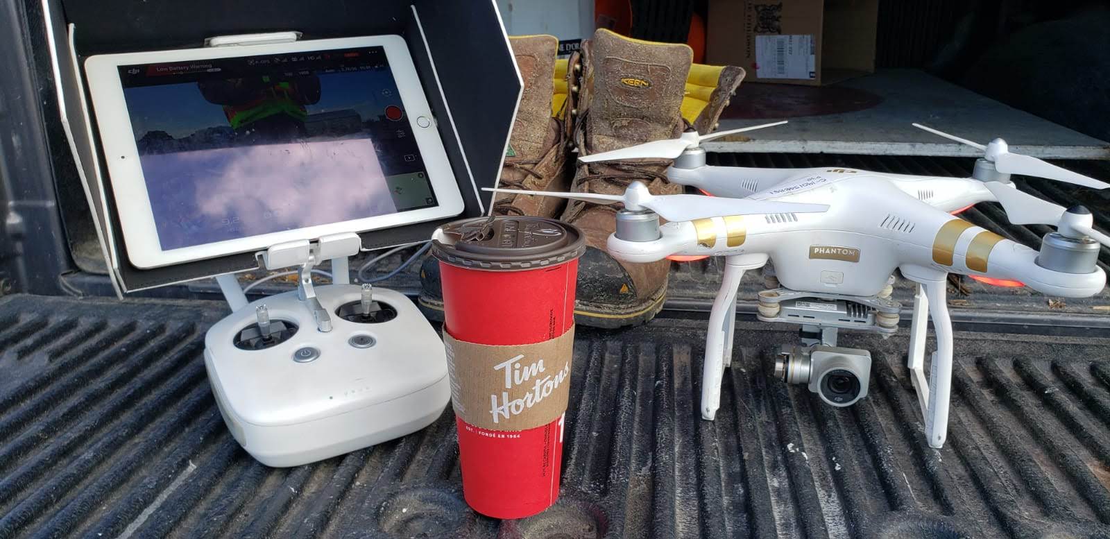
Clarion Drone Academy Inc. new EVLOS testing facility
2019 was another amazing year for us at Clarion Drone Academy.
We saw a year filled with new clients and travelled to new countries to share our experience and expertise. South America, Africa and the United States of America were top of our list this year and continue to be a hot bed of activity and we look forward continuing our work there.
Not to be outdone, Canada has seen its share of exciting new drone companies and Clarion is proud to be working with two up and coming startups from southern Ontario. We can hardly wait to share more of that news in the new year. 2020 has great things planned for us including a new EVLOS (Extended Visual Line of Sight) testing grounds with over 1000 acres of private land to test and fly your aircraft. This new proving grounds is based only a few hours north of Toronto and has built in drone testing facilities in addition to being one of the only places in Ontario where RPAS flights are conducted with EVLOS.
Clarion's training programs and expertise in creating custom programs for their clients has seen an increase this past year from new upstarts and developed RPAS companies seeking help in developing their training programs . In our experience, Engineers enjoy developing new technology and making existing ones better. We enhance their work by removing the client training side to allow them to continue to create and develop.
This is why it was imperative to develop the Clarion EVLOS training facility to allow companies to test their technology and also be able to demonstrate in a closed and private setting to investors and government clients alike.
We welcome all inquiries and look forward to the expansive growth this new facility has to offer the RPAS community.
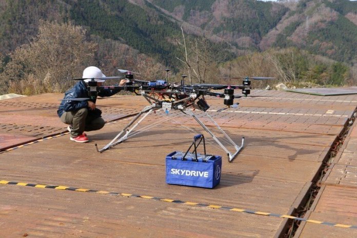
SkyDrive Inc., a leading flying-car developer, has successfully launched test flights of a cargo drone which could revolutionize the way heavy goods are transported and speed up the movement of equipment in remote locations. The first operational testing took place earlier this month (December) in Toyota City, Japan. It was carried out to test the technology by moving heavy equipment in remote locations. Additional testing will be carried out later in the month.
This new technology has been tested with a load capacity of 30kg — utilizing SkyDrive’s world-leading aircraft development technology to achieve high safety standards. There is the potential to develop this further and achieve greater capacity loads of up to 50kg and 80kg, according to demand. The cargo drone also has the potential to change the way products are moved from manufacturers to warehouses and onto depots.
SkyDrive Chief Executive Tomohiro Fukuzawa said: “We are delighted to successfully test this world-leading technology. Our cargo drone has proven to deliver by safely lifting loads of up to 20kg in a mountainous area — saving time and money. “We look forward to expanding on this success by testing heavier loads for customers in the future. Our quest is to create cutting-edge technology that will improve the productivity of businesses across the world — and today we celebrate a key milestone in making that happen.”
SkyDrive is developing the cargo drone for use in industries that carry heavy materials on complex terrain such as slopes, mountain valleys, overpasses, power transmission towers, civil engineering/construction sites, agricultural fields, etc. Usage of cargo drones will help avoid dangerous works, save personnel and shorten the term of works. So SkyDrive can contribute to responding to labor shortages and improving Japan’s labor productivity sagging due to its declining population.
Cargo drone technical details:
Can be used by companies for transporting materials to hard-to-reach places such as slopes, mountain valleys, overpasses and sites of steel tower maintenance.
Basic specifications:
- Total length 1.3m x total width 1.7m x total height 1.0m
- Recommended payload: 30kg
- Flight speed: 40km/h
- Flight time: 15min.
- Winch mechanism to move up and down without landing
Further information can be found here: https://en-skydrive.amebaownd.com/pages/3450667/drone
By Press
A part of the Japanese government has joined the U.S. in an effort to procure only drones made by non-Chinese companies
Dozens of drones to be replaced by other models due to security concerns
TOKYO -- The Japan Coast Guard plans to stop using and procuring Chinese-made drones in fiscal 2020 due to concerns over information security, Nikkei has learned. It will be the second case in which Chinese products are barred from consideration by Japanese government procurement programs.
Equipment from China's Huawei Technologies is also banned from consideration for government use.
The Japan Coast Guard is currently using a few dozen Chinese-made drones to conduct rescue and surveillance activities. The drones are reasonably priced and perform well but will be replaced by non-Chinese models.
The coast guard is tasked with search and rescue operations at sea, monitoring suspicious vessels such as North Korean fishing boats and safeguarding the waters around the Senkaku Islands, Okinawa Prefecture. China also claims these islands, which it calls Diaoyu.
The maritime agency plans to include costs for replacing its Chinese drones in its budget for fiscal 2020, which starts April 1.
The U.S. Defense Department has banned the purchase and use of Chinese-made drones. China's DJI, the world's biggest drone maker, is the chief target.
"We know that a lot of the information is sent back to China from those [drones]," Ellen Lord, undersecretary of Defense for Acquisition and Sustainment, said in August. They are "not something that we can use."
But the U.S. appears to have continued to buy Chinese-made drones in cases of "urgent need." The U.S. Air Force and Navy have also purchased Chinese-made drones even after they were banned.
The U.S. Department of Homeland Security in May warned U.S. companies of the risks to company data from Chinese-made drones. The notice, titled "Chinese Manufactured Unmanned Aircraft Systems," warned that U.S. officials have "strong concerns about any technology product that takes American data into the territory of an authoritarian state that permits its intelligence services to have unfettered access to that data or otherwise abuses that access."
In response to reports of the latest alert, the company issued a statement saying, "At DJI, safety is at the core of everything we do, and the security of our technology has been independently verified by the U.S. government and leading U.S. businesses."
Out of consideration of Washington's position, Tokyo is strengthening its economic security regulations and systems. The Japan Coast Guard's move is part of these efforts.
Japan in 2018 decided to exclude Huawei-made products from government procurement programs.
Last month, Japan enacted a revision to the foreign exchange law that has stronger restrictions on foreign investments in Japanese companies, an effort to prevent malicious acquisitions.
In April, the government will formally launch a team within the National Security Secretariat to act as the command center for foreign and security policies; it will specialize in economic affairs.
The U.S. is alarmed by China, which advocates "military-civilian integration" and is using advanced private-sector technologies to beef up its military capabilities.
The NSS command center team is meant to keep in step with U.S. foreign and security policies.
Japan's agriculture and delivery industries have been experimenting with drones as they search for ways to cope with the nation's deepening labor shortage.
According to a think tank of Tokyo-based Impress Corporation, the domestic drone market is expected to expand by 56% to 145 billion yen ($1.33 billion) in the current fiscal year through March and reach 507.3 billion yen in fiscal 2024.
Nikkei staff writers
DECEMBER 09, 2019
Image: Dronesense
Dronesense, which sells a platform for controlling drones to police, left customer data including flight plans exposed.
Dronesense, a company that sells a platform to government, law enforcement, and private clients for flying drones, exposed a database of customer data, in some cases showing exactly where users programmed their drones to fly.
The exposure not only presented a significant potential risk for the integrity of law enforcement investigations, but also gives new insight into how many police departments, safety services, and businesses are using drones across the United States.
Motherboard obtained some of this data and was able to plot drone flights from a police department onto maps. One showed a drone meticulously scoping out an apartment complex and its car park near Atlanta, Georgia. Another nearby flight marked as "disaster assessment" shows a drone flying over a playground. A third named "Mapping Mission" has nearly two dozen so-called "capture points," likely referring to spots for the drone to photograph, spread across a residential Washington D.C. neighborhood.
"If Dronesense was breached, then it's just another example of law enforcement putting too much faith in new surveillance technologies without fully accounting for the risks," Dave Maass, senior investigative researcher at the Electronic Frontier Foundation (EFF) said in an email. "In addition to potential harms to privacy, insufficient security of law enforcement systems can also undermine the integrity of criminal investigations and even the justice process."
The database is separated by different organizations, such as the Atlanta Police Department, Boise Fire Department, City of Coral Springs, Nassau County Police Department, and even U.S. Army Corps of Engineers.
The list included over 200 different entries, although some of those appear to be test or administration accounts. No drone camera footage was included, but as well as the flight path data, the data also contained what brand of drone each customer was using for the flight, the pilot's name, email address, and other technical information about the drone.
Dronesense's platform has several components: "Airbase" for storing data, "Pilot" for controlling a drone via an app, and "OpsCenter" to provide visibility into what multiple drones are doing and seeing at once. Cities have used Dronesense's platform for monitoring large events like the Indy 500 race and NFL games.

"Log flights automatically and view detailed playback," the Airbase description reads on Dronesense's website.
Those flight logs are some of the data obtained by Motherboard. As well as the flight marked as "disaster assessment," others are named "Mapping bug test" and "demo 1," suggesting some relate to demos or troubleshooting. In a statement, Dronesense said the data was exposed for just over a month.

Carlos Campos, a spokesperson for the Atlanta Police Department, wrote in an email, "The Atlanta Police Department began using a drone this year to assist us in a number of ways—primarily with providing us a convenient vantage point from which to manage large-scale events such as major sporting events and parades. We contacted DroneSense after your inquiry; the company acknowledged the data exposure and assured us it has taken measures to correct the flaw. We have no reason to believe any law enforcement-sensitive data was compromised as a result of the exposure. Still, the Department values the importance of data security and are discussing the issue further with DroneSense."
Law enforcement and public and private search and rescue organizations have been using drones in the U.S. for several years. Drones have been used to arrest and surveil people and have also been used to locate missing persons and to assist in rescue operations during natural disasters.
When drones were first being incorporated into American airspace, there was much controversy about law enforcement use, with groups like the ACLU and Electronic Privacy Information Center saying that new privacy laws were necessary before their widespread adoption. Several towns and cities put temporary moratoriums on drone use by government actors, but largely the controversy around their use has died down, and police drones have quietly proliferated around the country. According to the Center for the Study of the Drone at Bard College, at least 599 law enforcement agencies in the U.S. had drones as of 2018. But little research has been done into how those drones are being used, what they are surveilling, and their use in police work.
Do you work for a drone company? We'd love to hear from you. Using a non-work phone or computer, you can contact Joseph Cox securely on Signal on +44 20 8133 5190, Wickr on josephcox, OTR chat on jfcox@jabber.ccc.de, or email joseph.cox@vice.com.
Noam Rotem, an independent security researcher, discovered the exposed Dronesense data and flagged the issue to both Dronesense and Motherboard. Rotem explained that along with a friend he is scanning the web for leaky databases and came across the Dronesense data.
"Surveillance vendors often provide sales pitches that emphasize everything that can go right when a technology is deployed, but rarely do they address what might happen when the technology fails. This latest incident indicates that law enforcement should exercise more skepticism when acquiring new surveillance systems," Maass added.
When asked a series of questions, Dronesense provided Motherboard with the statement it is sending to its own customers.
"On December 3rd, DroneSense was notified by a security researcher of a potential vulnerability regarding a database located in our cloud-based infrastructure," the statement reads. "Within minutes of this notification, DroneSense identified and corrected a security flaw which had exposed a list of organization names within the DroneSense platform and, for a limited number of organizations, account data. At no time were live video streams or customer uploaded images, videos, documents, or media of any kind exposed by this flaw."
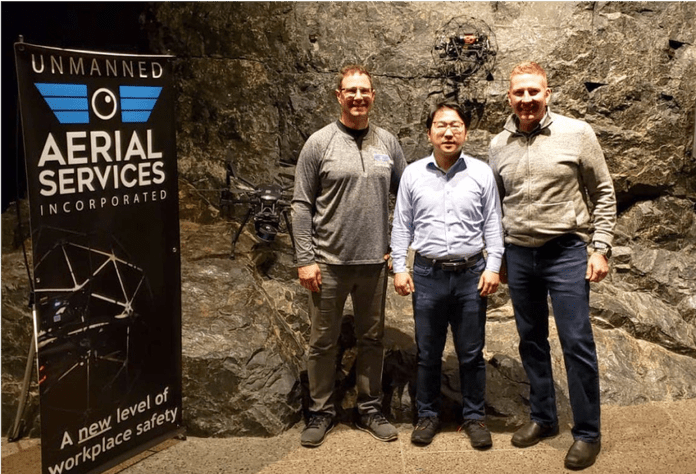
Japan’s Terra Drone Corporation, the world leader in industrial drone solutions, has signed an investment agreement with Unmanned Aerial Services Incorporated (UAS Inc.), an Ontario, Canada-based inspection service provider for indoor industrial confined spaces and underground mine locations. With this agreement, Terra Drone will form a new subsidiary in Canada, Terra Drone Mining, to provide cutting-edge unmanned mapping and inspection services to underground mines across the world.
Established in 2017, UAS Inc. counts among its clients some of the world’s leading mining companies including Vale, Newmont Goldcorp, Barrick Gold, and Glencore. The fresh infusion of investment by Terra Drone will allow the newly-formed Terra Drone Mining to expand UAS Inc.’s business beyond North America, and cater to areas of thriving underground mining operations such as South/Central America, South Africa, Central Asia, Russia, and Australia.
Accidents in underground mines have remained a serious issue around the world throughout the last century. Workers not only suffer from health issues caused by working in dark and narrow tunnels day after day, but they are also prone to accidents caused by falling material, flooding, as well as underground fires and explosions. According to the United States Mine Safety and Health Administration (MSHA), there have been more than 20 fatalities in US mines this year alone.
The risk of such incidents can be minimized by using unmanned inspection solutions, aka drones. Terra Drone utilizes a mapping technology called SLAM (Simultaneous Localization and Mapping) to create highly detailed maps of underground areas. Since a drone can reach areas that are not easily or safely accessible to humans or traditional CMS scanners, mine operators can use drones to obtain 3D models of the mines, and prevent workers from entering hazardous locations.
Terra Drone Mining will be able to leverage both this advanced UAV technology as well as the underground mining inspection know-how that UAS Inc. has cultivated over time to create a robust local service network.
For more details about the underground mining services Terra Drone offers, visit: https://www.terra-drone.net/global/solution-mining/

Complicated underground environments such as this crusher station can be easily captured in a single scan, to validate as-built conditions, and for clash detection for new engineering. (Sudbury, Canada)

This scan was captured, and interior artifacts removed, to create a model of the rock cavity prior to repurposing for new equipment. Unlike simple imagery, measurements can be made and the coordinate of any point can be queried in the point cloud. (Sudbury, Canada)

Scans are used to check clearances between rock surfaces, and existing infrastructure.
■ About Terra Drone Corporation
Established in 2016, Terra Drone Corporation has quickly become one of the world’s largest industrial drone solution companies employing over 550 drone industry professionals. The company’s head office is located in Tokyo, Japan, and more than 25 branches are spread globally throughout Asia, Europe, the Americas, Africa, and Oceania. Terra Drone provides innovative enterprise drone services for oil and gas, utilities, renewables, mining, construction, and GIS sectors, among others.
Previous investments include Unifly, which specializes in unmanned traffic management (UTM); C-Astral, which develops high-endurance fixed-wing UAVs; RoNik Inspectioneering, which provides wireless inspection services for confined spaces; Ventus Geospatial, which has patented gas leak detection technology; and Inkonova, which has developed SLAM technology for underground mines. Going forward, we will continue to invest in technology companies with cutting-edge solutions for drones.
By PRESS
In the era of e-commerce, it takes a single click to order anything you’d like. But it takes a lot of energy to bring it to your door.
Items are shipped from factories, shuttled between warehouses and finally trucked to your home. This convenience comes at an environmental cost — transportation accounts for 29% of U.S. greenhouse gas emissions, with medium- and heavy-duty trucks accounting for nearly a quarter of that.
Technology enables this problem — and some will tell you that technology can help solve it.
Drones have been touted as a clean, fast way to appease our demand for quick deliveries. When Amazon.com Inc. unveiled a new design in June for its Prime Air delivery drone, it framed the initiative as part of its vision to make half its shipments net zero carbon by 2030. Wing, a division of Google parent Alphabet Inc., heralded its service as helpful in easing greenhouse gas emissions. After UPS first publicly flew a drone from the top of a delivery truck to drop off a package at a home, an executive called the test a “big step” toward reducing UPS’ emissions.
Drone delivery operations could indeed be more environmentally friendly than trucks, according to two recent studies. But that depends on how and where they are deployed.
Where they plug in
Small drones have a lower environmental impact than ground-based delivery methods, including diesel trucks, trucks powered by natural gas or even electric vans, according to a study published last year in Nature Communications. But drone batteries need to be charged, and that power has to come from somewhere.
For drones to live up to their green potential, plugging into clean power sources is vital. Access varies from state to state and from utility to utility.
Thanks to solar power, California frequently generates more electricity than people can use. The study in Nature Communications concluded that a one-pound package delivered by a small drone in California would reduce greenhouse gas emissions by 54% compared with a diesel truck. The same delivery in Missouri, which gets most of its electricity from coal, would result in a reduction of just 23%.
“When you have low-carbon electricity and you’re moving small packages, drones could have the lowest carbon footprint per package delivered,” said Costa Samaras, associate professor of civil and environmental engineering at Carnegie Mellon University and a co-author of the study. “It’s much greener to have a drone flying through the air to deliver you a set of headphones than for you to get in your gasoline-powered car or even your electric car and drive to the store and get it.”
Companies testing commercial drones are already experimenting in regions with varied power sources.
Wing operates commercial drone delivery service in Christiansburg, Va.; Canberra, Australia; and Helsinki, Finland. In Canberra, Wing is powered by nearly 100% renewable energy, while Helsinki uses a mix of nuclear energy, renewable energy and fossil fuels, said Jonathan Bass, Wing’s head of marketing and communications. Virginia, on the other hand, is predominantly powered by natural gas and nuclear energy. All three locations’ power sources are getting cleaner over time, he said.
The fewer warehouses, the better
The longer a drone can stay in the air and deliver packages, the more useful it is.
But drones have much shorter ranges than trucks, and charging stations are far less common than gas stations.
So delivery companies will need a vast network of charging stations. It’s easy to put those stations in warehouses, where the drones go anyway to load up on packages.
Because of our desire for quick deliveries, the nation is already seeing a warehouse boom. One billion square feet of warehouse space was built nationwide over the last decade, with a big boom in the Inland Empire, a CBRE study found last year.
Building a broader network of warehouses to accommodate drones’ needs would have serious environmental repercussions. More warehouses means more lighting, heating and air conditioning systems, not to mention the energy required to charge drones between flights, all of which add to the overall emissions from the service.
Rather than building new warehouses, drone delivery companies could use existing facilities — for example, drones carrying food could take off from the top of a grocery store. Amazon would be well positioned to do that, as it already has more than 500 Whole Foods stores and is experimenting with new grocery concepts.
Developing higher-capacity batteries for drones could also help: If drones could fly farther, the network of warehouses and chargers could be less dense. (Currently, drone use in the United States is limited by rules against flying over humans or beyond the operator’s line of sight. But those rules are expected to loosen in the years ahead, and some companies already have waivers.)
Another option is deploying drones from delivery trucks when removing a few packages could streamline a driving route. The truck covers much of the distance — then takes a big load of packages one way while a drone carries some the other. Then the drone can meet up with the truck to make other such deliveries and eventually be returned to the warehouse.
A study published last year in the journal Transportation Research Part D concluded that drones are best at delivering a few packages at a time, while trucks are better at taking large quantities to more densely populated areas.
“It’s important to remember these modes can be used in complement,” said Anne Goodchild, a co-author of the study and director of the supply chain transportation and logistics center at the University of Washington. “We shouldn’t just compare drones versus trucks.”
Off the beaten path
The logistics industry has inched toward some environmentally minded solutions in urban areas, such as Amazon Lockers, where a single gas-powered truck might drop off packages for dozens of customers. But that approach doesn’t necessarily work in rural areas, where residents are more spread out and trucks haul packages to every doorstep.
That’s where drones could be a more efficient way to carry packages on the “last mile” of delivery, researchers say, especially since there are fewer obstacles — such as power lines and buildings — for them to avoid.
“A drone can’t really compete with a very full truck making 100 deliveries in a fairly small space,” Goodchild said. “The farther apart those customers are, the less room for consolidation, the more competitive a drone can be.”
But they won’t be able to handle everything, at least initially. The current crop of drones envisioned for delivery service are lightweight, meaning they can only carry small, light packages over short distances.
Although drones may end up improving on the traditional ways of delivering packages, they aren’t a silver bullet to vanquish the transportation industry’s emissions problem. For example, Wing’s drones can carry packages of up to 3 pounds, which could replace some trips to the store but not a delivery truck’s entire route.
“We do not expect them to replace delivery trucks for delivery of larger items, but rather to make them more efficient,” Wing’s Bass said in an email.
Drone delivery is not just a gimmick — companies will use it widely if it saves money, said Tyler Reeb, director of research and workforce development at the Center for International Trade and Transportation, based at Cal State Long Beach.
“It’s more of a calculation of risk and expense, with environmental benefits being a nice byproduct,” he said.
By SAMANTHA MASUNAGA STAFF WRITER, LA TIMES
Times staff writer Suhauna Hussain contributed to this report.
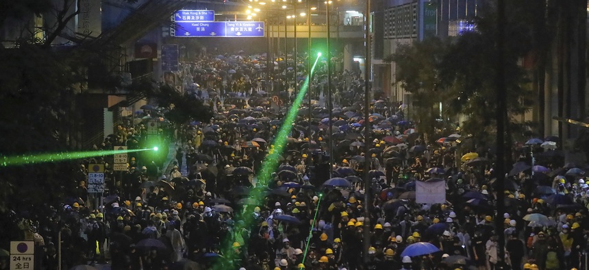
Demonstrators, some using laser pointers toward police lines during a protest in Hong Kong, Sunday, Aug. 25, 2019. KIN CHEUNG/AP
Video of Chilean protesters using beams of green light to ground a police drone made the rounds on social media Wednesday. But those aren’t tractor beams or Green Lantern rings—the protesters appear to be using run-of-the-mill laser pointers to take down law enforcement-grade technology. How does that work?
Chilean protesters took to the streets last month to speak out against a proposed increase in public transit fares, though the demonstrations have now turned into a countrywide expression of anger over low wages and inequality.
Video posted to Reddit late Tuesday appears to show training laser pointer pens on a police drone in an attempt to bring it to the ground. As more light beams make contact with the unmanned aerial system, or UAS, it falters, then almost escapes before a coordinated effort brings it slowly to Earth.
The laser pointers could have taken down the drone in the video in one of two ways, according to Christopher Williams, CEO of Citadel Defense Company, which is working with Customs and Border Protection to deploy anti-drone “bubbles” along the border.
If the drone was being flown manually by an operator watching through a first-person video, the bright lights might have blinded the camera, causing the operator to lose control. Alternatively, “low powered lasers have the ability to interfere with [infrared] landing sensors,” as well as the downward-facing cameras that detect obstacles below, “forcing a landing or uncontrolled drone behavior,” Williams said.
Commentators on Reddit offered a third possibility: that the combined heat from all those laser pointers was enough to melt internal wiring or cause the battery to give out.
Beyond drones, laser pointers are fast becoming the tool of choice for protesters around the world. In Hong Kong, people in the streets are using laser pointers to mess with facial recognition and other surveillance technologies.
While effective for grassroots purposes, Williams said he does not believe low-powered lasers like these will become widely adopted as counter-drone measures.
“Use of these types of lasers is more hazardous and disruptive to humans than it will be for drones,” he said. “There are many other technologies that are less disruptive that provide a superior, more scalable, more reliable and more cost-effective countermeasure.”
That said, high-powered lasers are certainly being developed to destroy or otherwise knock drones out of the air. Just last month, the Raytheon delivered the Air Force a high-powered laser to down drones. Rather than scrambling sensors or blinding operators, the high-powered versions turn up the heat, melting a drone’s components or internal wiring or causing batteries to explode.
Raytheon declined to comment for this story.
The Air Force isn’t the only military branch looking at lasers for counter-drone technology. The Army Fires Battle Lab has been developing an experimental program called the Mobile High-Energy Laser, or MEHEL, since 2017.
“The industry as a whole is focused on creating a menu of CUAS sensor options that can be adapted to different use cases and price points,” Williams said. “As the threat outpaces government responsiveness and legislative decision making, drone threats and less conventional countermeasures will continue to be an issue.”
By Aaron Boyd,
Senior Editor, Nextgov
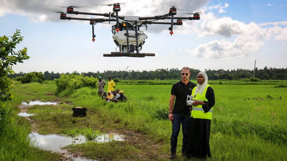
ZANZIBAR, Tanzania
For the first time drones are being tested to help fight malaria on the island of Zanzibar, off the coast of Tanzania.
The drones will spray a silicone-based liquid on rice paddies, where there are large expanses of stagnant water where malaria-carrying mosquitoes lay their eggs. The substance will spread across the water and prevent the eggs from hatching. It is hoped this will significantly reduce the numbers of the malaria-carrying anopheles mosquitoes in the area.
The spraying by drones is a test to see if it will help the government of Zanzibar reach its goal of eliminating malaria on the archipelago by 2023, according to the strategic plan adopted by Zanzibar Malaria Elimination Program.
The drone spraying is a relatively inexpensive way to stop the mosquitoes from reproducing, said Bart Knols, a medical entomologist and lead researcher of the program.
"We are getting to the bottom of it as we will spray the breeding grounds of mosquitoes," said Knols, who is with the Dutch Malaria Foundation.
The drone will spray Aquatain, a liquid gel that will spread over a section of water and kill mosquitoes' larvae, said Knols. The substance has been tested internationally and has been found to be harmless to non-target organisms, non-toxic and biodegradable.
In the initial test, in the Cheju area of southern Zanzibar, the drone flew over and sprayed the shallow, sunlit water bodies in the rice paddies teeming with mosquito larvae, which were trapped as the gel spread across the water. Without the gel, the larvae would have emerged as adult mosquitoes in search of a blood meal. When those mosquitoes bite humans infected with malaria, they become vectors for the disease and continue its deadly transmission cycle.
Along the Indian Ocean coast of East Africa, Zanzibar and mainland Tanzania have had a long, well-documented battle with malaria.
In the last 10 years, Zanzibar, with a population of 1.2 million people, has embarked on different methods of fighting malaria. Thousands of mosquito nets have been distributed to put over beds and insecticide was supplied to spray in homes.
The campaigns have succeeded in decreasing the disease's prevalence. Some areas of Zanzibar have seen the prevalence of malaria drop from 40% of the population to less than 10%, according to the malaria elimination program.
The spraying by drones is a new part of the strategy. The use of drones will be essential to efficiently spraying the large rice fields, which have been identified as malaria hot spots on Zanzibar. The drone is efficient because spraying by hand is very time consuming and using a helicopter is too expensive, said Eduardo Rodriguez of DJI, a Chinese drone manufacturer.
With the help of drone pilots from the State University of Zanzibar, the DJI Agras drone is being tested to spray the rice paddies.
"The ultimate vision of our fight against malaria is to bring malaria down to zero in year 2023 as our target,"said Abdullah Suleiman Ali, manager of the Zanzibar Malaria Elimination Program.
BY ALI SULTAN ASSOCIATED PRESS