Site blog
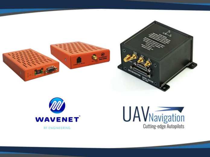
A robust communication network between an unmanned aerial vehicle and the ground control station is paramount for the successful execution of a BVLOS (Beyond Visual Line of Sight) operation. Although the UAV Navigation VECTOR autopilot, UAV’s most advanced flight control system is fully capable of executing an entirely autonomous mission, a solid and reliable data or video link is essential. It facilitates the reception of information from the various subsystems in the aircraft, such as cameras, transponders, etc… This information enables the operator to make quick and effective decisions during a mission.
Real-time monitoring of the platform is critical to evaluate the risk involved in the mission and to ensure flight safety. In the same way, secure transmission of telemetry through encrypted data is essential to prevent attacks and interferences. The flight control system developed by UAV
Navigation has the proven ability to fly beyond 300 kilometres using a UHF datalink. It is specially designed by WAVENET RF Engineering to make UAV operations safer and more convenient. In the testing phase, the high quality of the link was proven, even under adverse conditions. This collaboration has shown the capabilities of both systems and the excellent relationship between the two companies involved.
Flight Control Solutions designed for Secure Communication
Apart from the size, power consumption, work frequencies, and available bandwidth, there’s one more key parameter that must be taken into account — secure data transfer. So, while choosing a radio link, it is imperative to make the decision based on the data link’s ability to seamlessly transfer data, without any loss of information. The visualization of the status by the operator and the quality of the link is very important in order to take preventive actions before the aircraft is seriously damaged. For that purpose, Visionair, the mission control software developed by UAV Navigation includes a panel that displays data transmission statistics.
UAV Navigation’s flight control systems are designed to ensure flight safety. Although UAV Navigation’s flight control systems enable the platform to execute a completely autonomous mission, a radio link is essential. From take-off to landing, UAV Navigation knows the importance of monitoring the mission and being able to react during the flight. For this reason, we delve deeper into this issue, by working with some of the best datalink manufacturers. We spend time understanding the underlying challenges in providing an excellent communication link to the operators. Doing this allows operators access to valuable information, which enables them to successfully complete the mission.
By Press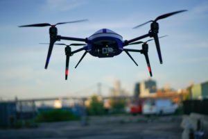
Image : Easy Aerial
Easy Aerial is a small company with a big list of customers that include the U.S. AirForce, the Department of Defense, Department of Homeland Security and Border Patrol, and more – all performing applications that the company can’t discuss. But this week, Easy Aerial drones are helping to provide security for one of the biggest parties in the U.S.: Miami’s SuperFest.
The Miami-Gardens Police Department will use the fully autonomous, drone-in-the-box solutions to help them secure the 5 day celebration leading up to this weekend’s Super Bowl. SuperFest brings almost 600,000 people into an area that is normally a vast parking lot – an area without much permanent security infrastructure. Even for the Miami-Gardens P.D., who are used to parties, that creates a security challenge; but it’s one that Easy Aerial’s autonomous and tethered drone systems can help manage.
NY-based Easy Aerial designs and manufactures fully autonomous systems. In 2018, the company won a U.S. AirForce challenge for new technology to protect U.S. soldiers – and their drone-in-the-box systems, which can be driven in an F-150 pick up truck, were developed initially to AirForce and government specifications.
Miami-Gardens P.D. will use two drones – one that will launch and fly on a scheduled system for perimeter security. The second is the same box, with the same drone – but attached to a cable, which provides communications and power. “The tethered system can fly for 16 – 18 hours straight: no radios, cyber immune,” says Ido Gur, Easy Aerial’s co-founder and CEO. The drone is incredibly easy to use, requiring no piloting skills, and is designed to respond instantly when launched: “In 5 seconds, the box opens – and in 20 seconds it reaches max altitude, in this case 200 feet,” says Gur.
Officers can drive the F-150 pickup while the drone, which is equipped with a high resolution zoom camera, is in the air; giving them a birds’ eye view of the celebrations and enabling the team to monitor crowds and respond quickly to any problems. “This is the tool they need for this event,”says Gur. “We’re very proud of this – it’s a high profile event. I truly believe that a birds-eye view at 200 feet is something that can save lives – it can really make the police much more efficient in times of crisis.”
After SuperFest is over? There’s the potential that the drones can be used for many other events, or to help in case of hurricanes or other disaster events. “This is a tool for mass events and for crises – one of the benefits of our drone is that it flies in extreme winds,” says Gur. Easy Aerial drones can carry more than just cameras, also. “We just did a project with DHS where the payload was not a camera, but a special radio that provides internet for a one-mile radius,” says Gur. “That’s a huge benefit in a crisis. We’ve done payloads with loud speakers, searchlights – it’s a very versatile payload capability.”
With lots of potential for the future, this week, the Miami-Gardens P.D. will be using Easy Aerial Drones to help 600,000 partiers celebrate safely – that’s a win regardless of Sunday’s result.
Posted By: Miriam McNab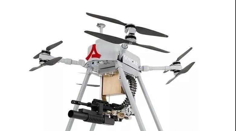
Asisguard, a Turkish electronics manufacturer, is installing machine guns on the eight-rotor drone Songar, and when the drone is delivered to the military, Turkey will be the first country in the world to have such a drone. The 25-kilogram drone carried 200 rounds of bullets and could fire a single shot or fire 15 rounds at a time.
Many countries and military organizations are already using drones capable of carrying bombs, but Songar will be the first drone with firearms installed.
Drones are difficult to shoot accurately. Songar used two systems to overcome the challenges. One used sensors to measure distance, angle, and wind speed. The other used a set of robotic arms to move the machine gun to compensate for recoil caused by firing. .
Asisguard claims that Songar can hit a 15 cm area from 200 meters, enough to hit a human-sized target.
By Cindy Cui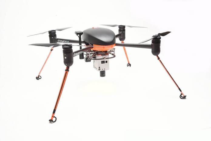
Draganfly Inc. (CSE: DFLY) (OTCQB: DFLYF) (FSE: 3U8) (“Draganfly” or the “Company”), an award-winning, industry-leading manufacturer within the commercial Unmanned Aerial Vehicle (“UAV”) and Unmanned Vehicle Systems (“UVS”) space, today announced three new specialized payload offerings, which are intended to expand agricultural research and environmental monitoring using drones.
Draganfly’s wholly-owned subsidiary, Draganfly Innovations Inc., has developed these new payload options in collaboration with research experts in agricultural and water resources fields. These new camera packages, which have now been added to Draganfly’s existing product line, are intended to increase efficiency and improve the spatial and spectral quality of actionable data collected.
The Corning microHSI hyperspectral sensor is capable of recording up to 155 user-selectable light bands, which allows researchers to narrow their focus to the specific light spectrums they want to target. This sensor is being used across various industries including precision agriculture, environmental monitoring, and oil & gas.
Draganfly now offers and supports this sensor package on the Draganflyer Commander UAV platform as well as the DJI M600 Pro.
The first of two dual-sensor packages is the 100MP Phase One Industrial iXM-100 still camera paired with the MicaSense RedEdge-MX multispectral 5-band sensor, which offers simultaneous capture of multispectral and high-resolution visual imagery. These two cameras are impressive in their own right, but what makes this payload package even more powerful is the payload control system that allows for georeferencing and automatic, simultaneous camera shutter and data logging. This dual payload is available now and supported on the DJI M600 Pro platform.
The second of the two dual-sensor packages is the 42MP Sony a7R still camera paired with the MicaSense RedEdge-MX multispectral 5-band sensor. This payload offering, like the above-mentioned dual sensor payload, also offers simultaneous capture of multispectral and high-resolution visual imagery, but at a more attractive price point.
“We are excited to offer systems and equipment to researchers and government agencies looking to improve on their current data collection methods. We’re confident these payload offerings can add immense value” stated Cory Baker, Production Manager, Draganfly Innovations.
The sensor packages in these new payload offerings have been integrated with the aircraft’s autopilot, flight control system, and mission planning software to allow automatic planning, push-button flight execution, and data collection driven by the user’s resolution and data quality requirements.
These specialized payloads have been developed with agricultural and environmental research organizations in mind. University-led research programs and federal agencies that Draganfly collaborated with include the University of Saskatchewan’s Plant Phenotyping and Imaging Research Centre (P2IRC), the University of Saskatchewan’s Global Water Futures, and the Government of Canada’s Department of Agriculture and Agri-Food.
About Draganfly
Draganfly Inc. (CSE: DFLY; OTCQB: DFLYF; FSE: 3U8) is the creator of quality, cutting-edge, UVS and software that revolutionizes the way people do business. Recognized as being at the forefront of technology for over 21 years, Draganfly is an award-winning, industry-leading manufacturer within the commercial UAV and UVS space, serving the public safety, agriculture, industrial inspections and mapping and surveying markets. Draganfly is a company driven by passion, ingenuity and the need to provide efficient solutions and first-class services to its customers around the world with the goal of saving time, money and lives.
By Press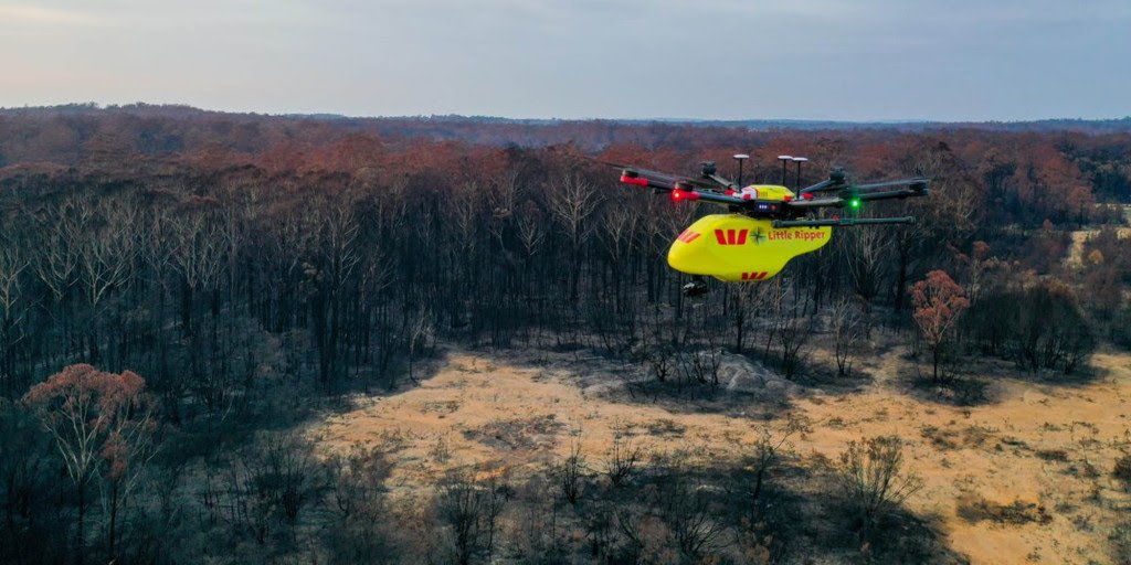
Animal rescue group WIRES has partnered with Australian UAV to get drones into the air to measure and track the wildlife that managed to survive the devastating Australian bushfires. The Ripper Rescue Alliance has also been created and has deployed its drones to help with the massive task ahead.
Drones to measure wildlife losses in the Australian bushfires
The first drones to hit the skies were deployed last Thursday in the early hours of the morning around the Batemans Bay and Mogo areas. The drones were equipped with infrared and vision cameras to look for injured wildlife.
Group coordinator for the Ripper Rescue Alliance Ben Trollope said there is a possible future for the Little Ripper drones to be deployed with food and water to be dropped at feeding stations around the affected areas.
Ben Trollope also said the drones can cover 100 hectares and were deployed in the early hours of the morning to get the best results from the infrared cameras locating wildlife on the ground.
The drones were also able to locate patches where the fires didn’t reach, and within those patches, the drones would spot up to 20 Kangaroos and Wallabies, a great sight in such devastation.
Drones were also brought in to help investigators at the crash site of the C-130 Hercules water tanker, which went down while fighting the bushfires. What are your thoughts on drones being used in the long recovery process caused by the Australian bushfires?
Photo: The Ripper GroupBy Josh Spires
Wojtek Behnke, 36, has trained his flock of ewes to follow a drone CREDIT: ANDREW FOX/ANDREW FOX
A Shropshire farmer has become the first person to train sheep to associate drones with food so they can be herded "hands-free".
Wojtek Behnke, 36, is getting his 300-strong flock of breeding ewes to follow the airborne device by giving them nuts at the same time as it flies overhead.
Farmers have previously tried to make their herds afraid of drones by programming them to emit a barking sound, which encourages them to walk away from the noise in the desired direction.
But the clever beasts quickly cotton on to the fact that the drone is not going to hurt them and start ignoring it.
To tackle this impasse, Wojtek decided to use positive reinforcement.
This is the first time a farmer has used this method to tackle the centuries-old conundrum of how to speedily and efficiently herd sheep.
"I was looking on the internet and saw drones were being used to herd sheep so I though 'let's give it a go' and it worked," Wojtek told The Telegraph.
He teamed up with his sister's colleague Mark Rutter, professor of Applied Animal Behaviour at Harper Adams University, who was pioneering the positive reinforcement method.
Together, they hatched a plan to train the ewes to associate the drone with food.
Wojtek set up a tube going into a trough in the sheep's field and hid behind a hedge, secretly dropping food down it while flying the drone overhead. He stayed out of sight so the sheep didn't end up associating him with food rather than the drone.
Eventually, the sheep started coming to the trough when they heard the drone even if there was no food. This then led to them following the drone around.
The method harks back to the work of Russian physiologist Ivan Pavlov who used positive reinforcement to train dogs to associate particular noises with food.
Professor Rutter told The Telegraph: "Farmers traditionally get sheep to move by either putting a dog behind them or getting sheep nuts. Sheep learn it's a nice tasty treat and will follow you. But if they're spread out over a large area then they're probably not going to hear you shaking the nuts.
"The drone frightening mode quickly becomes ineffective the more you use it.
"Sheep are prey species and responsive to possible threats. They are described as stoic and don't want to give away that they're injured - something prey animals exhibit - because if predators think they can't run away as quickly, then they'll target that sheep.
"They run away from the drone initially then quickly realise it's not a threat and ignore it. But the more positive reinforcement is used, the more effective it becomes.
"It's certainly time-saving and would help improve the welfare of millions of sheep across the country."
By Phoebe Southworth
The Perimeter XLRS can fly for up to 5 hours while maintaining command and control links and streaming real-time video up to 60 miles / 100 km
Skyfront, the leading provider of hybrid-electric Unmanned Aerial Vehicles (UAVs), and Silvus Technologies, a leading provider of Multi-Input Multi-Output (MIMO) communications, announced today a partnership that combines Skyfront’s five-hour endurance Perimeter UAV with Silvus’ high-power StreamCaster radios. The combined product, the Perimeter XLRS, can fly for up to 5 hours while maintaining command and control links and streaming real-time video up to 60 miles / 100 km from the ground control station.
This partnership has enabled UAV operators to inspect pipelines and power lines and perform surveillance missions across the world. The Perimeter’s onboard StreamCaster radio provides the Perimeter with a steady, reliable video and control link. The StreamCaster’s MIMO and beamforming technologies successfully overcome range limitations, signal attenuation and multipath interference, to allow the Perimeter XLRS to operate in environments where other data links typically fail, such as in maritime, mountain, and jungle deployments.
The Perimeter XLRS’s integration of the StreamCaster is comprehensive. It includes:
- Latency-free manual/joystick and waypoint control up to 60 miles away
- RF/EMI protection from the powerful onboard radio
- Testing and integration with numerous sensor payloads
- H264/H265 encoding for any HDMI-output camera
- A fully integrated ground station with directional ground antennas
- Seamless power and harnessing
- AES256-encrypted video and control links
- Elimination of interference between GNSS unit and radio
“The integration of the StreamCaster into the Perimeter line of UAVs has enabled it to fully utilize its extreme endurance and fly beyond-line-of-sight (BVLOS) missions with ease,” said Troy Mestler, CEO of Skyfront. “We are very excited to be partnering with Silvus Technologies to bring long-range aerial platforms into the mainstream.”
“Silvus Technologies is proud to have Skyfront as one of our UAV partners. The Perimeter XLRS’s ability to support long endurance VTOL flight with the Silvus MN-MIMO waveform makes it a unique differentiator in the marketplace,” said Kasey Cooper, Director of Unmanned Systems at Silvus Technologies.
About Skyfront
Skyfront manufactures the longest endurance hybrid-electric multirotor drones in the world, with proven flight times of 5 hours. Skyfront’s UAVs are designed and equipped for beyond-visual-line-of-sight missions, including video, telemetry and control links up to 60 miles (100 km) away from the ground control station. Customers use the Perimeter 4 and 8 for inspection and surveillance missions worldwide due to extremely long flight times, communications range, safety, rapid deployment, and ease of use. For more information, please visit www.skyfront.com.
About Silvus Technologies, Inc.
Privately held and headquartered in Los Angeles, Silvus Technologies develops advanced MIMO technologies that are reshaping broadband wireless connectivity for mission-critical applications. Backed by an unmatched team of PhD scientists and design engineers, its technologies provide enhanced wireless data throughput, interference mitigation, improved range, mobility, and robustness to address the growing needs of its government and commercial customers. For more information, please visit www.silvustechnologies.com.
By Press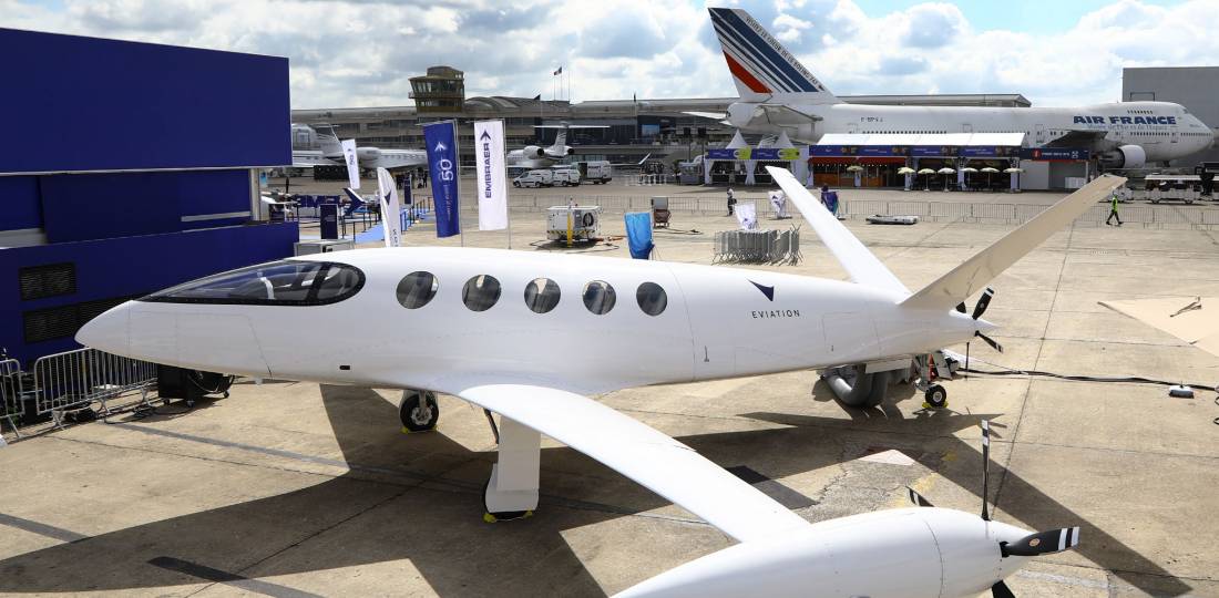
A fire broke out during ground testing of Eviation’s all-electric Alice aircraft on January 22 at Prescott Regional Airport in Arizona. The company said that the fire is believed to have been caused by a fault with a ground-based battery system. It has yet to confirm how extensively the prototype aircraft might have been damaged in the incident.
The Prescott Fire Department was on standby for the planned test and quickly extinguished the fire, which caused no injuries. Eviation has begun an investigation into the full cause of the fire and has not said how the incident might affect plans to begin flight testing the aircraft.
Israel-based Eviation is aiming to complete type certification for the fixed-wing Alice before the end of 2022 under the FAA’s Part 23 rules. The first prototype arrived in Prescott in late 2019, having been shipped from Vannes, France, where it was assembled at facilities owned by composite fuselage supplier Carboman Group.
Two more prototypes are due to be delivered to the U.S. this year. Eviation pushed back plans to begin flight testing in late 2019 into 2020. The company has been doing development work in partnership with the Embry-Riddle Aeronautical University’s Prescott campus, but intends to conduct Alice’s flight testing at Moses Lake in Washington.
Alice is being designed to carry nine passengers on flights of up to around 650 miles and at speeds of up to almost 280 mph. The aircraft is powered by three electric motors provided by Magnix, which is part of the Singapore-based Clermont Group that is now the majority shareholder in Eviation.
It has a 900-kWh battery pack powering electric motors that drive three variable-pitch propellers—one installed in the tail of the aircraft, and one on each side of the wing. The combined power of the three electric motors is 260 kW. Full charge time for the batteries is projected at 70 minutes, or 30 minutes to provide enough power for a 60-minute flight.
Eviation said the $4 million aircraft will offer direct operating costs of just $200 per flight hour. U.S. operator Cape Air placed the launch order for Alice in a June 2019 deal for an undisclosed number of aircraft. The company claims to have total "orders" for 150 aircraft with more than one customer but has not disclosed the names of any other prospective operators.
By Charles Alcock AIN Online
In the not so distant future, more and more drones will be flying around delivering packages, performing utility work, taking real estate photos, and helping with emergency services. When that time comes, how do we ensure those drones can safely fly in our neighbourhoods? That’s the question that Bob Roth, a director with Amazon Prime Air, is working to solve. Roth and his team are developing a traffic management system that will support safe low-altitude airspace operations, enabling collaboration and communication between drones regardless of who is operating them.
“We will always prioritize safety first within our system,” said Roth. “People both on the ground and in the air are the most important to protect. We’re building a traffic management system with this as our guiding principle.”
Roth, an eight-year Amazonian who started his career leading software for the Amazon Kindle e-reader, admits there are challenges with introducing an entirely new way to manage traffic in the air.
“Similar to when I started with Kindle, this is a new frontier,” said Roth. “We’re at a stage now where we are working with industry and regulators to test how different drones from different operators can fly safely together.”
To do this testing Bob’s team has been busy working with NASA and Single European Sky ATM Research (SESAR), on trials using the Amazon air traffic management system.
He’s also chairing an industry standards group, working to build standards for drone traffic management — which are basically rules that help ensure all drones can fly safely in the air. All while, at the same time, building his global teams in Seattle, Tel Aviv, Cambridge, and Paris.
Navigating a drone through the air is very different than a car driving on a road. In the air, there are no roads or fixed routes so there are many more options to get from point A to point B.
To manage all these possible routes for the Prime Air vehicle fleet, the system Roth’s team is building is automated, which means that unlike the traditional air traffic control system used today which requires a lot of human intervention to guide manned aircraft, a sophisticated set of automated functions both on and off the drones will ensure safety and reliability. For additional safety, drones will fly at low altitudes (for example, below 400 feet) so it would be very unlikely for them to be in the same airspace as aeroplanes or helicopters.“
PEOPLE BOTH ON THE GROUND AND IN THE AIR ARE THE MOST IMPORTANT TO PROTECT. WE’RE BUILDING A TRAFFIC MANAGEMENT SYSTEM WITH THIS AS OUR GUIDING PRINCIPLE.
Bob Roth – director, Amazon Prime Air”
The system also gives aviation authorities, like the FAA, the ability to track the drones in the airspace to ensure safety and create “no-fly zones” in times of emergency.
The traffic management system is easy to use for various operators in the same airspace because it will connect via the internet, LTE, or another cloud-based connection so each system can talk to the other. A drone flown by a crew filming for a movie supported by one traffic management provider will be able to be in the same airspace and communicate with a drone delivering a package being supported by another provider. It’s the same way mobile phones work today. A person who has a mobile phone with one wireless carrier can easily talk or text with someone who uses a different network because of the way they systems connect with each other.
In the end, all of this work is being done to benefit customers.
“Small aerial drones will soon make a big difference in our lives,” said Roth. “Whether it’s bringing medicine to a parent who has a sick child late at night or doing a search mission for a lost hiker. It’s exciting to be at the forefront of building technology that will benefit so many people.”
Building an air traffic management system is just one exciting area the Prime Air team is working on as they move toward making their vision of safely delivering packages to customers in 30 minutes or less a reality.
By Press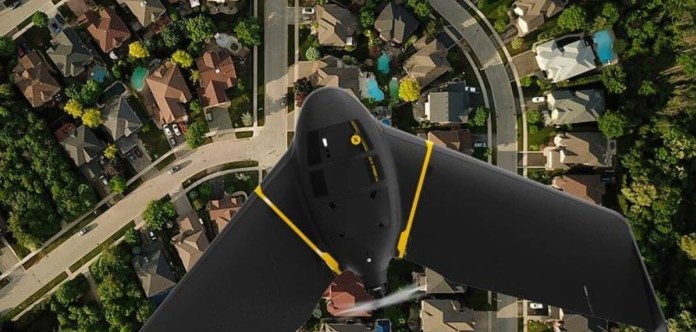
senseFly, the global leader in fixed-wing drones, is proud to announce that its flagship eBee X fixed-wing drone was approved for operations over people by Transport Canada, as defined by the regulatory body’s standard 922.06 Remotely Piloted Aircraft Systems (RPAS) safety assurance designation.
The designation is part of Transport Canada’s self-declaration process, which provides a path for drone manufacturers to self-declare the operational safety of their drones, provided the aircraft meets a series of strict requirements.
To operate safely over people is an important milestone for the senseFly eBee X, and the news will no doubt please drone pilots and operators in Canada.
Operations Over People (OOP) is also a fundamental requirement for professionals looking to expand their mapping capabilities with Beyond Visual Line of Sight (BVLOS) mapping missions, of which the eBee X is capable of flying.
The eBee X joins the eBee Plus—the most popular fixed-wing drone in US and France—, the eBee SQ and eBee Classic in satisfying the requirements outlined by Transport Canada, making it legal for drone operators to fly and operate the drones safely over people.
“The senseFly name is synonymous with efficient fixed-wing drones, but it’s quickly becoming synonymous with safety, too,” said Gilles Labossière, CEO of senseFly. “Whether you’re using it to corridor map an oil pipeline or surveying a mine site or for precision agriculture, the eBee X was designed to deliver accurate results while adhering to the strictest safety standards.”
The senseFly eBee X received Transport Canada’s safety designation by meeting the following criteria:
Protections against Injury to Persons on the Ground
- No single failure of the RPAS may result in a severe injury to a person on the ground within 5 m horizontal of the RPA in operation.
- The occurrence of any combination of failures of the RPAS which may result in a severe injury to a person on the ground within 5 m horizontal of the RPA in operation must be shown to be remote.
Warning and Alerts
- Systems, controls, and associated monitoring and warning means must be designed to minimize RPAS pilot errors that could create additional hazards.
senseFly is pleased to receive its latest designation from Transport Canada and will continue its position at the vanguard of the fixed-wing drone industry with end-to-end drone solutions that meet the exacting requirements of drone operators.
By Press