Site blog
Simple, Low-Cost Solution Meets Government Expectations To Identify Airborne Drones
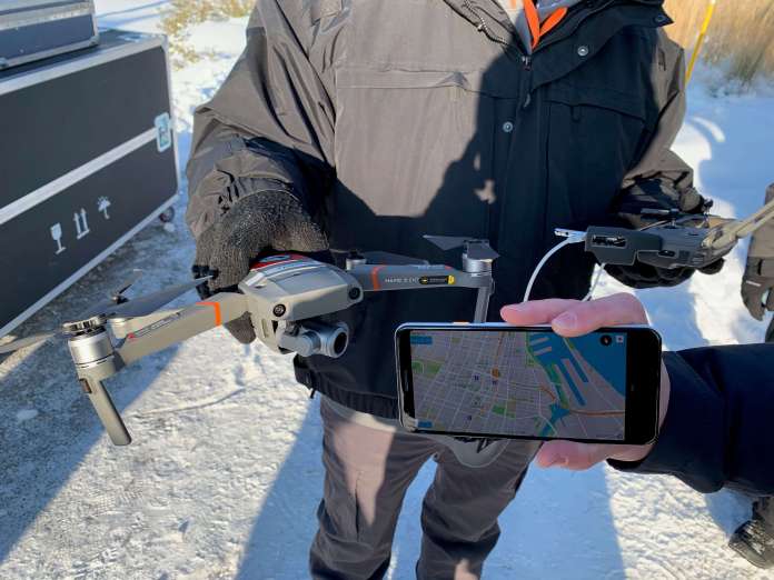
DJI, the world’s leader in civilian drones and aerial imaging technology, today demonstrated a direct drone-to-phone, Wi-Fi based solution to remotely identify airborne drones, pioneering an easy way for anyone with a smartphone to monitor nearby drones for enhanced safety, security and peace of mind.
DJI’s remote identification solution, developed in collaboration with industry stakeholders and regulators, broadcasts information from drones directly to off-the-shelf mobile phones using existing Wi-Fi protocols. Using a simple app, anyone within radio range of the drone can receive that signal and learn the location, altitude, speed and direction of the drone, as well as an identification number for the drone and the location of the pilot.
“Remote ID functions as an electronic license plate for drones, allowing anyone who is curious about a drone in the sky to learn more about what it’s doing,” said Brendan Schulman, DJI Vice President of Policy & Legal Affairs. “Around the world, aviation authorities have said remote ID is the key to allowing more complex drone use, and to solving concerns about safety and security. DJI’s direct drone-to-phone remote ID shows we’re committed to providing a solution in a way that is instantly usable worldwide without any additional infrastructure.”
DJI demonstrated the direct drone-to-phone remote ID system at a park in Montreal, Canada, during the International Civil Aviation Organization’s third annual Drone Enable conference. Participants used standard phones from Samsung, Google and Xiaomi to receive Wi-Fi Aware signals from a DJI Mavic Air drone and a DJI Mavic 2 Enterprise drone.
“Our direct drone-to-phone solution is an easy and elegant solution for drone pilots. They will be able to comply with Remote ID expectations simply by updating the software on many drones already in widespread use, without any extra cost or equipment,” said Javier Caina, DJI Director of Technical Standards. “In contrast, remote ID solutions that require pilots to add telecommunications equipment, subscribe to an ID service provider, connect to a cell tower or buy a data plan for their drone will create new costs and barriers for beneficial drone operations. DJI’s direct drone-to-phone solution uses the latest technological advances to make remote ID compliance as easy and inexpensive as possible.”
Aviation regulators in many countries are moving to require remote ID systems for drones as a solution to concerns about drone safety and security. The U.S. Federal Aviation Administration (FAA) has said it will release a mandatory remote ID proposal by the end of this year. The rulemaking process will take more than a year to complete, but an FAA industry committee has urged manufacturers to develop voluntary remote ID systems in the interim. The European Union Aviation Safety Agency (EASA) will impose remote ID requirements in July 2020. The app and the associated drone firmware updates used for DJI’s demonstration this week are not yet available for public use, pending further direction from aviation regulators and final publication of the ASTM International standard.
“As more drones take to the skies every day, remote ID addresses the public’s interest in understanding what’s happening in the airspace,” said Christian Struwe, DJI Policy Director, Europe. “DJI’s drone-to-phone implementation helps accomplish that by allowing drone pilots to broadcast a simple description of their flights, so anyone viewing the smartphone app can understand that they are inspecting a roof, surveying a construction site, or performing another beneficial task with a drone.”
DJI’s system was built to conform to the forthcoming ASTM International standard for broadcast drone remote ID, developed over a period of 18 months by a broad group of industry and government stakeholders. The solution uses the Wi-Fi Aware protocol for mobile phones, which allows the phones to receive and use the Wi-Fi signals directly from the drones without having to complete a two-way connection. Because it does not need to connect to a Wi-Fi base station, a cellular network or any other external system, it works in rural areas with no telecom service. In DJI’s preliminary testing, the Wi-Fi Aware signals can be received from more than one kilometer away.
“Wi-Fi is the premiere way to connect devices in the modern era, and we are pleased that Wi-Fi Aware from Wi-Fi Alliance® provides a reliable, virtually cost-free solution for drone Remote ID that can be implemented in many drones with just a software update,” said Wi-Fi Alliance, a worldwide network of more than 850 companies. “Wi-Fi Alliance will help facilitate broad industry collaboration on implementation of Wi-Fi Aware as this solution is adopted by manufacturers and policymakers.”
The new direct drone-to-phone solution is an evolution of the broadcast methodology pioneered by DJI AeroScope, the professional remote ID system first introduced in 2017 for airports, prisons, stadiums and other critical locations protected by police departments and other government agencies. AeroScope broadcasts a drone’s location, altitude, speed, direction and identification number, as well as the location of the pilot, using different radio protocols that can be received from miles away by special receivers developed for safety and security authorities who most need it.
By Press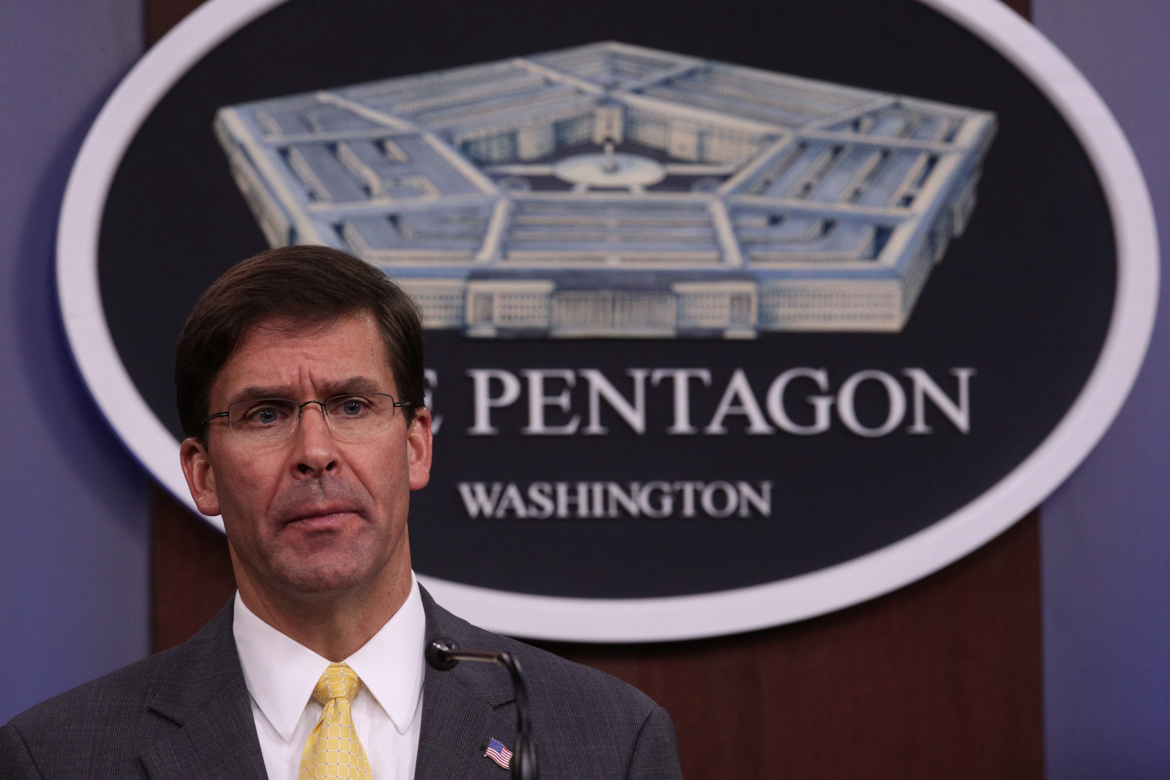
U.S. Secretary of Defense Mark Esper. Credit: Alex Wong/Getty Images
U.S. Secretary of Defense Mark T. Esper called working with China on A.I. ‘a short and narrow-sighted focus on economic opportunity’
U.S. Secretary of Defense Mark T. Esper spoke out against China’s sale of highly autonomous drones on the international market for the first time today, calling into question China’s previous position that autonomous robots were dangerous and posed a “humanitarian concern.”
“As we speak, the Chinese government is already exporting some of its most advanced military aerial drones to the Middle East, as it prepares to export its next generation stealth UAVs [unmanned aerial vehicles] when those come on line,” Esper said today during a conference organized by the National Security Commission of Artificial Intelligence. “In addition, Chinese weapons manufacturers are selling drones advertised as capable of full autonomy, including the ability to conduct lethal targeted strikes.”
This is the first time a top U.S. official has spoken about China’s sale of lethal autonomous drones, even though it is suspected that the machines have been sold to countries in the Middle East since at least late 2018. Chinese state media has publicized the availability of autonomous lethal drones for months.
The rhetoric highlights concern from within the administration about China’s military A.I. ambitions, and highlights the DoD’s sense of immediacy in grappling with how China is spreading its autonomous technology across the world.
Two Chinese companies backed by government funds have been widely identified as vendors of lethal drones. Ziyan, which partnered with the Chinese ministry of public security last year, sells drones that can be outfitted with guns or bombs. State-owned Chinese Aerospace Science and Tech Corporation has also shown off its autonomous aerial weaponry.
The Chinese government has not publicly endorsed the use of autonomously lethal robots and state officials partially endorsed the Stop Killer Robots campaign, a worldwide organizing effort to ban such machines. That said, China has not condemned the research and development of autonomously lethal drones, and never indicated it would ban the technology from use on the battlefield.
The U.S. military has used human-controlled and semi-autonomous drone strikes in seven countries to date, sparking international outcry. The Department of Defense spent $7 billion of its 2018 budget developing the technology. It has also sold unarmed surveillance drones to allied countries in the South China Sea.
Esper also cast China’s use of artificial intelligence as a tool to impose authoritarian rule over its population, especially Muslim Uyghurs.
“All signs point to the construction of a 21st century surveillance state designed to censor speech and deny basic human rights on an unprecedented scale,” he said, urging the A.I. community to stop enabling Chinese firms’ unethical use of the technology.
“Equally troubling are the outside firms or multinational corporations that are inadvertently or tacitly providing the technology or research behind China’s unethical use of A.I.,” he said. “Our collective security must not be diminished by a short and narrow-sighted focus on economic opportunity.”
By Dave Gershgorn OneZero
Encouraging responsible use ‘desperately needed to ensure a collision between an aircraft and a drone is avoided’, says head of flight safety at airline pilots’ union
Drone users in the UK must now pass an online theory test and register as an operator for £9 a year, or face a £1,000 fine.
Children or adults wanting to fly a drone or unmanned aircraft such as a model plane weighing at least 250g will have to take the test to show they can do so “safely and legally”.
Those who fail the test or do not register by 30 November will face a fine of up to £1,000 under new regulations from the Civil Aviation Authority (CAA).
Dr Rob Hunter, head of flight safety at airline pilots’ union Balpa, said encouraging responsible drone use is “desperately needed to ensure a collision between an aircraft and a drone is avoided”.
He said: “We have been calling for drone registration for some time now as we believe that in the same way that other vehicles – be it those in the air or on the ground – are registered, so should drones.”
Registrants will be given a unique ID which must be displayed on their devices in a process costing £9 which must be renewed each year.
The theory test will have 20 multiple choice questions, with applicants needing 16 correct answers to pass. It can be taken as many times as required.
Drone sightings at Gatwick in December last year caused around 1,000 flights to be cancelled or diverted over 36 hours, affecting more than 140,000 passengers in the run-up to Christmas.
A number of other airports have been forced to suspend flights for several hours due to drone activity this year, including Heathrow.
UK Airprox Board figures show there were 125 near-misses between drones and aircraft reported in 2018, up by more than a third from 93 the previous year.
In March, the drone no-fly zone around airports was extended from 1km (0.6 miles) to 5km (3.1 miles).
The platform will also be used to help return lost drones to their owners.
Anyone losing a drone is advised to post their details on the Drones Reunited platform, while anyone who finds one is encouraged to check if it has a registration number and enter the details online.
Jonathan Nicholson, CAA assistant director of communications, said: “The service is about giving something back to the community, helping responsible drone owners and operators to be reunited with lost drones and continue flying.
“Our aim is for the Drones Reunited platform to become an essential service for the drone community – the first port of call for anyone who has lost or found a drone.”
The U.S. Department of Interior announced Wednesday that it would ground it’s fleet of DJI drones. The decision, which is the result of congressional pressure, is the latest move in the argument over banning government use of technology based solely upon “country of origin”: a direct blow to Chinese manufacturers.
The Ban on Chinese Manufactured
The proposed ban on Chinese-manufactured drones stems from legislation currently under discussion in Congress. As the U.S. trade war with China heats up, legislation has appeared proposing that no drones manufactured in countries deemed “non-cooperative” may be purchased by the U.S. government, citing data security concerns. The two pieces of legislation proposed are the American Drone Security Act in the Senate, and the Drone Origin Security Enhancement Act in the House. The Senate version would limit all government agencies from purchasing Chinese drone technology, the House version refers only to the Department of Homeland Security.
Chinese-founded DJI, the largest global drone manufacturer, denies strenuously that data gathered by DJI drones is at risk: and has struggled to respond to security concerns which do not refer to any technical standards or specific technology gaps. The legislation represents a move by the U.S. government that the U.S. press largely refers to as “getting the Huwei treatment,” a reference to the blacklisted Chinese telecom company: recent months have seen legislators proposing closer examination or bans on Chinese video app TikTok and others. In a statement concerning the American Drone Security Act, DJI officials said “banning or restricting the use of drone technology based on where it is made is fear-driven policy not grounded in facts or reality.”
DJI and the Department of the Interior
The U.S. Department of Interior move to down its fleet of about 800 drones is significant. The Department of the Interior (DOI) is tasked with maintaining public lands, and has adopted drone technology widely to help monitor land and deal with firefighting efforts, flood management, dam inspections, and tracking of endangered species. Fortune reports that the entirety of DOI’s fleet have Chinese manufactured parts, and at least 15% are manufactured by DJI: downing the fleet means halting critical programs.
DJI has long partnered with the Department and collaborated on finding a solution to the problem. DJI worked with the DOI on a 15-month long study to determine if security gaps existed, and how they might be addressed. The result of that study was DJI’s “Government Edition” offering and a decision by DJI to do some manufacturing in the U.S. Satisfied with the results of the study, DOI has previously resisted halting the use of Chinese-manufactured drones.
What Changed?
Senator Rick Scott (R-FL), a sponsor of the American Drone Security Act and a staunch opponent to Chinese manufacturing, along with other congress members, have brought pressure to bear on the department pending the passage of the proposed Drone Security legislation.
Wednesday, DOI spokesperson Melissa Brown delivered the following statement to The Verge: “Secretary Bernhardt is reviewing the Department of the Interior’s drone program. Until this review is completed, the Secretary has directed that drones manufactured in China or made from Chinese components be grounded unless they are currently being utilized for emergency purposes, such as fighting wildfires, search and rescue, and dealing with natural disasters that may threaten life or property.”
“Following many conversations between my office and the Interior Department, I’m glad to see the Department has seen the light and reversed course,” said Scott in a statement. “We should not, under any circumstances, put American national security at risk by using taxpayer dollars to purchase Chinese tech.”
“We are aware the Department of Interior has decided to ground its entire drone program and are disappointed to learn of this development,” a DJI spokesperson told The Verge in a statement. “As the leader in commercial drone technology, we have worked with the Department of Interior to create a safe and secure drone solution that meets their rigorous requirements, which was developed over the course of 15 months with DOI officials, independent cybersecurity professionals, and experts at NASA. We will continue to support the Department of Interior and provide assistance as it reviews its drone fleet so the agency can quickly resume the use of drones to help federal workers conduct vital operations.”
Posted By: Miriam McNabb
Software tested and validated by AIRT in the Bahamas under austere, real-world disaster conditions during the aftermath of Hurricane Dorian
DENVER, CO – Pix4Dreact, the eagerly awaited 2D fast-mapping software for public safety and emergency response professionals operating drones for good, was officially launched last month by Pix4D, the world’s premier source of drone mapping and photogrammetry software tools.
Pix4Dreact allows users to create 2D maps from aerial imagery in a fraction of the time needed by other mapping programs. This provides first responders and disaster response professionals with a much-needed edge when lives are on the line and time is of the essence.
Pix4Dreact has been field-tested and validated by emergency teams operating drones for disaster response. The Miami-based Airborne International Response Team (AIRT) recently used Pix4Dreact for aerial mapping with drones in Marsh Harbour, the Bahamas to help assess the devastation from major Category 5 Hurricane Dorian.
“We needed a solution that would allow us to rapidly process imagery on-scene under severe conditions with no available power source or mobile Internet connection,” says Christopher Todd who serves as the executive director of AIRT as well as a command staff member of the South Florida Region 7 All-Hazards Incident Management Team (FL-7 AHIMT). “Pix4Dreact worked perfectly. This software will help transform the workflow for disaster response teams around the world who are operating drones during emergencies.”
Unlike traditional mapping programs which typically require Internet access and can take several hours to render a map, Pix4D can rapidly and accurately process drone imagery directly on-scene without mobile connectivity. Todd believes this will be a game-changer for first responders and emergency services professionals who are operating drones.
“With the old workflow we needed to take the data off the drone, transport it back to a command post or emergency operations center, process the data – which might take several hours, and then push the end product back out to the field for use by response teams,” says Todd. “Pix4Dreact allows responders to quickly process the data while still on-scene so it can be used much more quickly to help assess the damage, protect property, and save lives.”
With a workflow that is intuitive and simple to use, Pix4Dreact’s fast-stitching technology creates accurate 2D orthomosaic maps by combining a large number of aerial nadir images from UAS. Users can quickly measure, analyze, and mark these files, which are light enough to be easily sent via email as needed.
“We are excited that Pix4Dreact is now available for use by public safety and emergency services professionals around the world,” said Lorenzo Martelletti, Sales & Marketing Director, Pix4D. “We will continue to work with first responders and disaster professionals to help make the product even stronger.”
A webinar highlighting Pix4Dreact and AIRT’s use of the software in their response to the Bahamas is scheduled for early December. Pre-registration for the webinar is now open at https://forms.gle/R9FK39nXcRKoe7jd8.
For more information, to purchase or get a trial of Pix4Dreact, please visit: www.pix4d.com/react.
By Press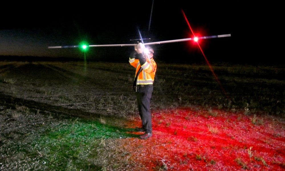
As a part of the joint project between UAVOS and Stratodynamics, UAVOS is excited to announce their latest successful record-setting stratospheric flight. The stratospheric glider named the HiDRON was released from a Canadian Space Agency scientific gondola at an altitude of 111,434 feet (33.9 km) and performed a four hour controlled flight and landed at Iroquois Falls Airport about 80 km from the Timmins, Ontario launch site. The flight once again confirmed the HiDRON’s capability to perform high-altitude missions and beyond visual line of sight (BVLOS) operations and set a new operational best for the flight in a challenging stratospheric environment.
Watch the HiDRON in action: http://bit.ly/2kux1J6
The night flight demonstrated the HiDRON’s beyond visual line of sight (BVLOS) capabilities and was supported by the Canadian Space Agency (CSA) and the French Space Agency (CNES) as part of the 2019 Strato-Science Balloon campaign at the balloon base in Timmins, Ontario.

The record setting flight achieved many firsts in Canadian Aviation:
- Highest altitude flight of a UAV or Remotely Piloted Aerial Systems (RPAS). RPAS is the name used by Transport Canada to encompass UAVs.
- First UAV above 29,000 feet in Class A airspace.
- First release of a UAV from a scientific gondola in Canada.
The HiDRON release from the CSA gondola is another first for the companies, as previous launches have been carried out by weather balloons, and added new layers of complexity. Prior to the launch, the Stratodynamics and UAVOS teams advanced aspects of the HiDRON including the transponder, stratospheric flight controls, data links, and safety protocols. The HiDRON features UAVOS’ autopilot AP 10.3 Micro.
The HiDRON was launched from the Timmins Victor M. Power Airport via the CSA scientific gondola at 10 pm on Saturday, August 31st. The mission plan was to release the HiDRON from the gondola sometime between an altitude of 30 km altitude and the target ceiling altitude of 37 km (121,000 feet). Once released the HiDRON would follow a pre-set flight plan and land at Iroquois Falls Airport. This meant the team was onsite at the Timmins airport until the gondola’s lift-off from the CSA Balloon Base.
As the gondola rose to its float altitude, the HiDRON was released at around 12:30 am on September 1st at an altitude of 111,400 feet. The HiDRON performed well in difficult headwinds and -60° C stratospheric conditions with its AMON detector recording single pixel data in a near-moonless night sky.
The record setting flight is the culmination of 12 months of international collaboration and planning with colleagues in Canada, Belarus and Slovakia and was the second of two flights commissioned to test AMON Airglow detector from Stratodynamics’ client, the Institute of Experimental Physics at the Slovak Academy of Science. The Slovakian team was searching for a cost-effective method for the AMON detector to have a clear view upwards unencumbered by a weather balloon blocking the view. The AMON detector is planned to participate in EUSO-SPB2 mission that will fly on a long duration NASA balloon in 2022.
Aliaksei Stratsilatau, CEO, UAVOS:
“HiDRON is a real solution that advances the important research around climate change and other atmospheric chemistry problems. The HiDRON provides solutions for tough problems that affect all of humankind, which is why it is such a necessary platform for researchers.”
Gary Pundsack, CEO Stratodynamics Aviation Inc.:
“We are extremely pleased with the outcome of this pioneering flight in Canadian Aviation, and the spirit of collaboration that enabled this successful campaign. Special thanks goes to our colleagues at Transport Canada and NAV Canada who provided considerable efforts to enable these firsts in Canadian Aviation. The Canadian Space Agency and the Centre National d’Etudes Spatiales also provided great support and assistance. And thanks to the Iroquois Falls Cadet Flying site who graciously provided use of their facilities. The September 1st flight once again confirmed the STRATODYNAMICS’ capability to perform high-altitude missions and beyond visual line of sight (BVLOS) operations and set a new operational best for the HiDRON’s flight in challenging stratospheric environment.”
By UnmannedNews.net
FOR MANY YEARS, Gökhan Çelik held roles in his native Turkey in large companies such as Siemens. While occupying mainly managerial positions, Çelik is a software engineer at heart and was feeling the itch to work on technical projects of his own.
“I wanted to get into a business where I can use my technical skills more and I wanted it to be something that can last for my son, for generations.”
This was around 2013, just as drones, or unmanned aerial vehicles (UAVs), were on the cusp of exploding in popularity while companies such as Amazon were revealing ambitious plans for drone deliveries.
Çelik and the company first started working on an autopilot product, a piece of software for others’ aircraft that guides it through the skies.
These were the origins of A-TechSYN, initially in Turkey, until the founders were wooed by IDA officials into moving the company’s headquarters to Shannon.
The company had already been plotting a move to the UK in order to gain access to the European market.
Çelik said he wanted to base the startup somewhere that was English-speaking and with a strong pool of software skills to draw from.
“We were looking to expand into Europe, and the world, but the US is too far away and too expensive,” he said. “I wanted somewhere that I can be closer to the Turkish market but also be a European market product.
“(Ireland) is at the cross-section of Europe, UK and the US. It just seemed to make sense.”
Hardware
At this time, the startup began looking at ways to expand its remit beyond drone software. The time had come to build its own drone.
“We started building and designing our own aircraft and we went out to our customers with them and they advised us to build something unique and then we came up with the idea that we could do a vertical take off and landing drone.”
A-TechSYN went on to build this aircraft that looks strikingly different from the quadcopter design that is usually associated with drones.
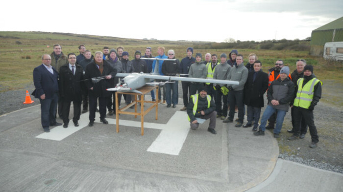
Rather, it resembles more of a mini-airplane with its five metre wing span. It weighs 55kg, carries a payload of 5kg and can fly for up to six hours.
“This is like a cross between small drones and big military drones,” Çelik said.
By building its own drone – hardware and software – Çelik said the company has greater control over development and how the technology can be used.
“We don’t need to go out and ask other companies to partner up.”
The company is working with the University of Limerick, which is using the drones at its robotics department for research and development.
Back home in Turkey, it has deals in place with law enforcement agencies who are using the drones.
Çelik said some of the primary use cases for its drones are inspections of oil and gas lines and offshore wind turbines as well as search and rescue missions, providing a cheaper alternative to helicopters.
“Ireland is an island so it has a lot of sea around it and our planes are especially good for inspection, geographical inspections or security or any type of patrolling and imaging, especially on the sea because of the high flight time (of our drone).”
Regulation
Those big ideas are well and good but the regulation of drones remains a major barrier to execution.
As it stands, UAVs must remain within line of sight of the owner or operator, which presents a significant challenge to Çelik’s plans.
He said the Irish Aviation Authority (IAA) is generally open to discussions with stakeholders and is confident that permits for out-of-sight use will be granted.
 Gökhan Çelik
“Basically it’s more about showing (the IAA) what we can do and then building up some trust and then getting to the next level of flight.”
Another Irish company, Manna, is hoping for a similar good relationship with Irish authorities as it tries to launch drone food deliveries.
A-TechSYN remains bootstrapped but Çelik said the time has come for the company to raise outside investment.
“In total we have done more than $10 million of revenue in the last six years but we never raised money,” he said.
“At this stage we need investment in the company so we can stay ahead of competition. We used to be around 24 months ahead of the competition, now we are like 12 or 13 months ahead.”
Founder: Gökhan Çelik
Elevator pitch:drones for asset inspections and law enforcement
Status: generating revenue from clients in Turkey and Ireland
Funding:bootstrapped but now on the hunt for VCs
BY JONATHAN KEANEREPORTER, FOR

By Gary Mortimer suasnews
Not a good look for a unit preparing to roll out a national registration scheme. Spotted early this morning by Drone Stuff This Week regular and gardening guru Ian Hudson the CAA has just released advice.
Let us hope the 4.1 million pound registration database has better security.
I shamelessly lifted the image from Twitter, created by @EmeraldSkyMedia
Unfortunately the CAA has been the victim of a sophisticated phishing attack resulting in a small number of emails being sent to external parties. We have taken steps to prevent this issue continuing including notification to the National Cyber Security Centre (NCSC) and our Email Infrastructure Protection Services.
We believe that you may have received one of these email messages from CAA contacts during this period, these messages may have a Subject line that is your name and include a URL or web link and words in the message body including ‘notification received’ or ‘notification snipped’. Please do not click on any links contained within these messages.
It may be that built-in email protection services have blocked the delivery of this message to you but if you have received a malicious message please consider the following advice:
Firstly, if you have simply opened the email then you need not worry – simply delete the email from your inbox and take no further action
If you have either clicked the link or followed the link and entered your logon details then PLEASE RESET THIS PASSWORD IMMEDIATELY
If you have any questions regarding this event please contact Information.Security@caa.co.uk with your contact details and we will respond to you as soon as we can.


As the trade war between the United States and China continues without an end in sight, it looks like the drone industry could be the latest to be affected by the economic dispute. The proposed American Drone Security Act 2019, which would ban the use of federal funds for purchasing drones manufactured in China, would forbid all federal entities in the United States from buying and using DJI platforms. But, as market share figures that we’ve gathered show, the global leader’s prominence in America is unlikely to be seriously shaken.

What Does This Law Mean?
If passed, the American Drone Security Act would mean that all of the federal entities which use Chinese made drones like the Department of Justice and the Department of Interior would have 180 days to cease using and purchasing them. In other words, police forces, fire departments, traffic controllers and many others would lose their drone fleets and have to either find other vendors or give up using drones. In late September, DJI launched a disaster relief program for US first responders. This programme would give selected partners access to DJI hardware and software during and after major disasters. If the American Drone Security Act goes forward, then such a program would have to be scrapped.
How Does This Affect DJI?
There are approximately 600 DJI drones being employed by the DoJ at the moment. This is insignificant compared to the hundreds of thousands of DJI drones being used for private and commercial purposes in the United States. For that reason, the American Drone Security Act is unlikely to have a direct impact on DJI’s commercial prominence in both the world and the US. In the past few years they have focused their attention from the hobbyist market to the growing commercial drone market as it is more promising for them in the long run.
However, the ban on the public use of DJI drones could be a steppingstone towards commercial restrictions as well. Regardless, the United States government definitely won’t be making life easy for DJI as they ramp up import taxes on goods manufactured in China. So far, DJI has been passing on the brunt of these increased taxes by increasing the prices of their products.
Moreover, the allegations over DJI accessing and abusing user data may affect their reputation on the commercial drone market. For that reason, the claims that they could be storing and illegally using the data acquired by their platforms abroad are being taken very seriously by the company. They’ve responded stating that these are baseless accusations and assuring their users that they are in no circumstance taking or using their data.
What About the Public Bodies Using DJI Drones?
While DJI sales won’t necessarily be directly hurt if the new law is passed, the US Interior and Justice departments would be left looking for other platforms. The current market shares of drone manufacturers in the US do not reveal many alternatives.
Both Yuneec and Autel Robotics are Chinese-owned manufacturers who are likely going to be affected by the law as well, and regardless of that do not manufacture more general platforms like the ones used by the DoI and the DoJ. Although Intel does rank high in terms of market share, this is largely due to the high number of their Shooting Star platforms, which are only used for drone shows and not actually sold externally.
Meanwhile, other prominent companies on the Top 10 list include manufacturers like GoPro and 3DR who no longer produce hardware, and hobbyist manufacturers like Holy Stone whose platforms are not suitable replacements for these use cases. Moreover, as many have already noted, it will be difficult for the public sector with its budget limitations to replace DJI drones at the same or even competing price point. Currently it seems like European and American companies are poised to take up the helm, most specifically Parrot. Their Anafi drone appears to already be part of the DoI’s ‘UAS Fleet’ which means that they are a likely candidate for the replacements for the 600 DJI drones that would be removed from operations.
What’s Next?
It is still unclear if the proposed act will actually pass. It currently has backing from both the Democratic and Republican Parties, meaning that it stands a good chance of being signed into law. However, DJI and their partners are working hard to make it clear that this would not be a wise step and that they can and should continue to support public bodies in the US.
Not only did they announce the new First Responders programme at their annual conference, Airworks, but they’ve also just released two new drones specifically built for applications in the agriculture industry. With these releases, and with their strong strategic partnerships in the US and across the globe, DJI is sending a clear message to the United States government: regardless of the proposed law which would ban the public use of their products, they are and will continue to be a driving force in the development of the commercial drone market.
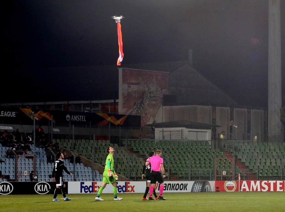
The Europa League group stage match was suspended after a drone flew over the pitch
FK Qarabag’s Europa League group stage match against F91 Dudelange was suspended on Thursday night after a drone carrying the flag of the disputed region of Nagorno-Karabakh was flown over the stadium.
Azerbaijani side Qarabag were leading their Luxembourgish opponents 2-0 when a drone appeared over Dudelange’s Stade Jos Nosbaum.
The drone, which was carrying the red, blue and gold flag, was then flown over the halfway line where it hovered for several seconds, over the heads of players from both teams.
Qarabag's Azerbaijani midfielder Gara Garayev then picked up the ball and attempted to kick it into the airborne drone, before the match was suspended.
Uefa said the match was postponed because of a “security issue”.
There are currently no diplomatic relations between Azerbaijan and Armenia owing to the ongoing Nagorno-Karabakh conflict.
The region, along with some neighbouring territory, has been under the control of Armenian soldiers and local ethnic Armenian forces since a 1994 ceasefire ended a bloody six-year war. There have been occasional outbreaks of violence since.
By Luke Brown Independent