Site blog
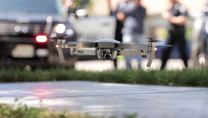
Axon (Nasdaq: AAXN), the global leader in connected public safety technologies, today announced a new drone piloting and livestreaming application that allows law enforcement to livestream critical data directly into Axon’s digital evidence management solution, Axon Evidence (Evidence.com). The Escondido Police Department in California was the first to use the application.
The first-of-its kind Axon Air app allows law enforcement to stream drone footage to command staff and into Axon Evidence in near real-time. The data is protected by the same rigorous data management system and chain of custody protocols that law enforcement agencies trust for body-worn, in-car and in-room video systems. Axon partnered with a network of agencies to develop the app, which includes customizable piloting controls and settings — about 30 agencies are using it in the field.
“We are excited to have a flight app that streamlines our workflow. From livestreaming in the moment to capturing the Evidence in a secure system, it makes our jobs easier and keeps everything consistent,” says Escondido PD’s Drone Program Coordinator and Chief Pilot, Sergeant Craig Miller. “Our pilots love the simple interface and the streaming allows us to get widespread awareness on any critical incident — the Axon Air app has been a game-changer.”
Drone technology is an important tool for Escondido Police in keeping its community safe — used in standard patrol activities, overseeing SWAT operations from above, aiding in missing people searches, gaining critical insights into traffic scenes, and used in city planning efforts.
“Drone technology is very valuable to public safety, but law enforcement officers have specific end-to-end needs that Axon is committed to serving,” says Axon CEO and founder, Rick Smith. “We will continue to partner with departments such as Escondido to deliver advanced situational awareness technology, automated pilot and flight records, advancements in scene reconstruction and more. Our goal is to make drone use easy and seamless, so agencies can take advantage of all the benefits of a drone program.”
Axon Air is Axon’s suite of software solutions for unmanned aircraft use in public safety. By leveraging the Axon Evidence platform, Axon Air gives public safety agencies another tool to improve officer and community safety. Integration with Axon Aware brings livestreaming and situational awareness beyond the body camera and into the sky. Through a strategic partnership with DJI — the global leader in civilian drones and aerial imaging technology — Axon Air software is tailored specifically to public safety use cases. The new piloting and livestreaming features of the Axon Air application are compatible with the Mavic 2 Enterprise and Matrice 200 series drones and accessories. Agencies can use their existing DJI drones or purchase them directly through Axon.
For more information on Axon Air visit: https://www.axon.com/products/axon-air or contact Axonair@axon.com.
By Press
Robyn Beck/AFP via Getty
A blind man who got lost in the freezing woods of Connecticut overnight was rescued with the help of a drone. The unidentified man got disoriented while walking and spent about 33 hours stranded in temperatures that dropped as low at 9 degrees, the Bridgeport Post reported. Police called in a drone pilot to search for him, and it spotted him 100 yards behind an embankment in about 30 minutes. “Due to the temperature, there was concern about hypothermia and it was clear that time was of the essence for a successful outcome,” the Enfield Police Department said in a Facebook post.
Tracy Connor
Executive Editor, Daily Beast
Parrot, Europe’s leading drone Group, has been chosen to equip the Swiss Armed Forces with micro-drones as part of the “Swiss Mini UAV Program” (Swiss MUAS) call for tender against major civilian UAV players.
Parrot’s expertise in professional drones, the performance of its solutions dedicated to Defence and Security, and the high level of cyber security required by the Swiss armed forces were decisive assets in the final choice.
The call for tender launched at the beginning of 2019 by armasuisse, the federal procurement agency responsible for the Swiss Armed Forces, is intended to get the right cost-effective training aids for the troops to become familiar with Mini UAV operations.
The safety of people and military personnel, as well as knowledge of the terrain, can be significantly enhanced and easily deployed thanks to the high-performant, light and evolving drones developed by Parrot.
Product specifications, quantities and prices are not disclosed. This structuring project marks a new step forward for the Parrot Group in the field of security and defence on which the Group has been working since 2018. On this occasion, the Group will be working with its subsidiary senseFly, which will be in charge of operational support in Switzerland.
Although the financial impact of this project will not be significant on the Group’s results, this new contract underlines the quality of the technological innovations developed by Parrot and its leading position in the civil drone market. It adds up to the development contract signed with the United States Army in May 2019 for the new generation of compact drones, dedicated to the surveillance of the SRR (Short Range Reconnaissance) program. These advances confirm the excellence of the Group’s R&D and testify to the quality of its strategy and positioning, particularly in the professional sectors and especially in the Defense and Security sectors.
ABOUT PARROT
Founded in 1994 by Henri Seydoux, Parrot is today the leading European group in the fast-growing industry of drones. Visionary, at the forefront of innovation, Parrot is the only group to be positioned across the entire value chain, from equipment to services and software.
• Parrot, the world’s number 2 of the consumer drone market, designs drones known for their high performance and ease of use.
• Parrot has a portfolio of outstanding companies and interests in commercial drones, covering equipment, software and services. Its expert capabilities are focused primarily on three vertical markets: (i) agriculture, (ii) 3D Mapping, Surveying and Inspection, and (iii) Defense and Security.
The Parrot Group designs and engineers its products in Europe, mainly in France and Switzerland. It currently employs over 500 people worldwide and makes the majority of its sales outside of France. Parrot, headquartered in Paris, has been listed since 2006 on Euronext Paris (FR0004038263 – PARRO). Financial information can be found on http://corporate.parrot.com. For more information: www.parrot.com and its subsidiaries www.pix4d.com, www.sensefly.com, www.micasense.com
By Press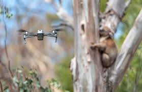
A couple of years ago, we shared the news that a forestry company in Victoria, Australia, was using drones equipped with thermal cameras to detect koalas before trees were cut down or controlled burns ignited.
In recent times, the wildfires devastating the same area of Australia have been anything but controlled. And sadly, those same methods have been required as part of a search and rescue initiative involving Victoria’s koala population.
A photo gallery published in today’s Guardian shows how DJI equipment is being used by Victoria Police to track down koalas in the aftermath of the fires. Many of the bears have suffered serious burns and require veterinary treatment
Habitats across the state of Victoria have been completely or partially destroyed, so work is underway to rehome koalas into nearby reserves. The only trouble is, detecting bears among the canopy – even when large areas of forest have been wiped out by bushfires – is extremely difficult.Ironically, the solution relies on the same element that caused all of this destruction in the first place: heat. Police and wildlife officers are using drones and thermal cameras to detect the heat signatures of the surviving koalas.
Once the bears are located, the team on the ground are using the drone to get a closer look and see if medical attention is required. If the bears are in need of assistance, the team are using cherry pickers to fetch them down.
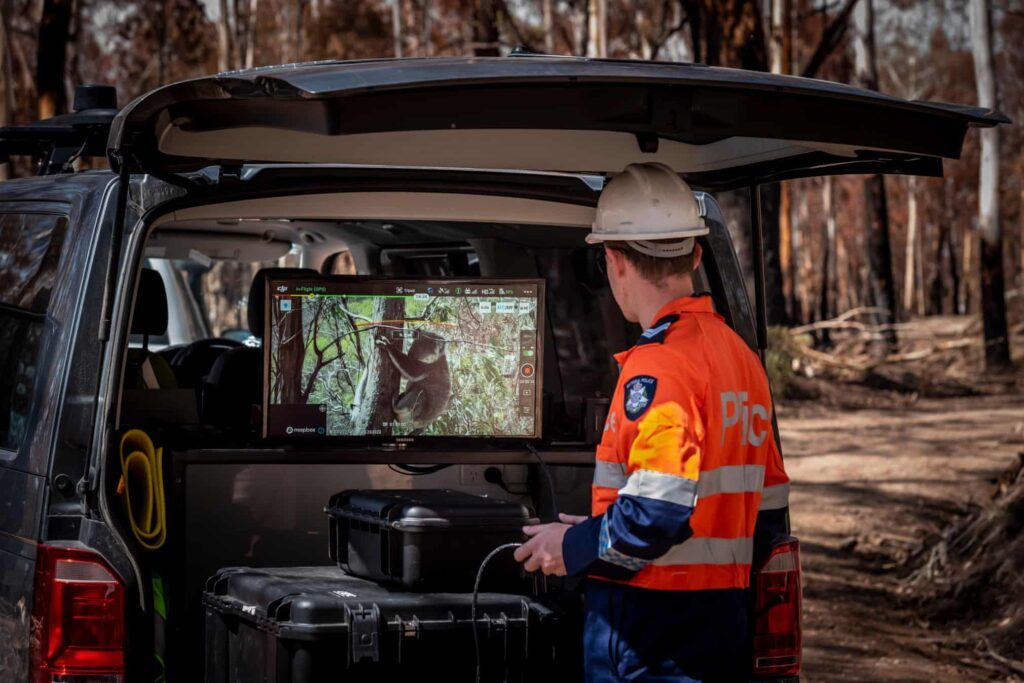
A member of the Victorian police drone unit uses a DJI drone to search for and assess koalas.
From what we can see, the emergency crews in Australia are flying DJI’s Mavic 2 Enterprise Dual. The commercial platform was launched at the end of 2018 and is designed to be used with a range of accessories as part of industrial inspection and public safety missions.
It looks as though DJI can add koala search and rescue to the list of applications.

A thermal shot of a koala.
Images from the Guardian.
By Malek Murison Dronelife
Commercially available drones have been used by militant groups such as the Islamic State group. (Bruce Bennett/Getty Images)
JERUSALEM — Rafael Advanced Defense Systems recently tested its counter-UAS system Drone Dome, during which the system identified and intercepted moving targets using a high-powered laser beam.
Drone Dome consists of electronic jammers and sensors to detect, identify and neutralize both micro and mini-UAVs. The demonstration by the Israeli company was carried out in a desert area with several types of drones, including commercially available quadcopters. A high-powered laser beam mounted on a jeep, along with the other Drone Dome sensors, detected the threat and enabled the crew to monitor its activity. A three-drone swarm was then neutralized using the lasers. One by one the drones fell from the sky.
Rafael exhibited seven drones that were destroyed by the laser. Burned impact areas showed their rotors and motors charred.
Swarms of small drones have proven to be a challenge for advanced militaries. In 2018, drones shut down Gatwick airport in the U.K. for about 30 hours. Small drones have also been used by militant organizations, such as the Islamic State group. And more than a dozen drones damaged oil infrastructure in Saudi Arabia in September 2019.
Drone Dome is one of Rafael’s numerous multilayered air defense systems. It also makes the land-based Iron Dome and a naval variant, C-Dome, as well as SPYDER, a surface-to-air missile system designed to counter aircraft, helicopters and UAVs.
Lasers are a key focus of Israel as it seeks to counter threats to its homeland. In August 2019, Hezbollah attempted to launch what Israel called “killer drones” near the Golan. A drone launched from Syria also penetrated Israeli airspace in February 2018 and was shot down by an Apache helicopter.
Israel’s Defense Ministry and the Directorate for Defense Research and Development are designing new laser solutions, and its new Momentum multiyear plan for the Israel Defense Forces envisions the increased use of laser technology to stop threats such as drones.
Last month, aerial footage emerged from a busy intersection in Shuyang, northern China. The video – admittedly a piece of state propaganda – shows drones equipped with loudspeakers being used by law enforcement. The purpose? To remind pedestrians to wear their facemasks in an effort to slow the spread of the Coronavirus.
This, it seems, is one way to slow down a pandemic in 2020.
The latest figures from mainland China put the death toll at higher than 700, with the number of confirmed Coronavirus cases standing at around 35, 000.
Outside China there have been 270 cases confirmed in 25 countries. The World Health Organization (WHO) has confirmed two fatalities – one in Hong Kong, another in the Philippines.
Surveillance drones aren’t the only way the technology is being deployed against the virus in other ways in China.
Last week, Chinese agriculture technology company XAG announced a 5-million-yuan fund for coronavirus response, which will be put towards aerial disinfectant sprays to curb the spread of the virus in rural areas.
The news came after the company’s fleets were used in China’s Shandong province on 28 January, where they reportedly disinfected a local community of over 300,000 square metres in less than 4 hours.

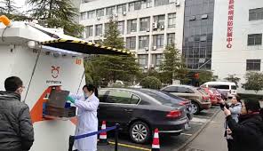
Terra Drone’s Antwork to transport medical samples in Zhejiang province
In recent days, Japanese drone company Terra drone has, through its group company Antwork, been developing a solution using UAVs to transport medical samples from the Hospital of Xinchang County to a local disease control center in Zhejiang.
Zhejiang province is one of the most severely hit by the virus. Already more than 1,000 patients have been diagnosed.
In order to support the various controls brought in to halt the epidemic, Antwork has been working with local hospitals to enable the timely and rapid delivery of medical samples and protection materials using its drone transportation network.
Antwork’s RA3 and tr7s drones and unmanned RH1 station will ensure that medical samples and quarantine materials can travel with minimal risk between Xinchang County People’s Hospital and Xinchang County disease control center.
By automating the process and taking humans out of the equation, the contact opportunities between samples and personnel in the transportation process will be dramatically reduced. Delivery speed also promises to be faster than transporting via road.

According to a press release, Antwork moved quickly following the Coronavirus outbreak in Wuhan.
The company contacted the health and disease control departments of various regions and petitioned to use drone transportation to support frontline medical institutions fighting against the epidemic.
After the project of Xinchang people’s hospital is put into operation, the company says, Antwork will aim to assist more medical institutions across China.
By Malek Murison
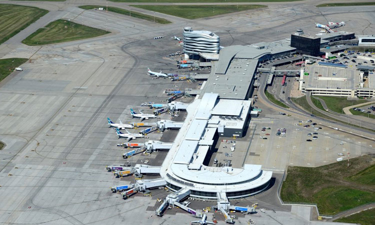
Steve Maybee, Edmonton International Airport’s VP of Operations and Infrastructure, details how by welcoming Unmanned Aircraft Systems (UAS) into its airspace, an airport’s operations will need to adapt and evolve.
During the last few months of 2019, Edmonton International Airport (EIA) deployed a highly-specialised drone to conduct runway safety inspections.
The Microdrone md4-1000 drone was flown to collect Lidar and imagery data of the airport’s runways. The data collected was used to more accurately predict when to conduct preventative maintenance on runways, taxiways and aircraft handling aprons; all with the ultimate aim of enhancing safety.
The drone operation was approved by Edmonton (one of the only airports in Canada using this technology) in collaboration with Nav Canada and AERIUM RPAS. Following this, International Airport Review spoke to Steve Maybee, Edmonton International Airport’s VP of Operations and Infrastructure, regarding how the use of drones will more widely affect airside operations.
What regulatory requirements are necessary for safe UAS operations at an airport?
Safety and security is our first priority and all drone operations at EIA are carefully managed in partnership with federal regulators, Transport Canada and Nav Canada, as well as the UAS companies involved.
Part IX of the current Canadian Aviation Regulations (CARs) permits the use of unmanned aircraft, under visual-line-of-site operations, in an aerodrome environment. An advanced pilots certificate is required to fly within controlled airspace, which requires passing of a written test as well as review by an approved flight reviewer.
The type of aerodrome and the category of surrounding airspace determine the applicable operating rules, pilot licencing requirements and aircraft safety standards. For those aerodromes in controlled airspace, approval is also required from NAV CANADA, the Canadian air navigation service provider, prior to conducting flight operations.
The existing CARs Part IX, and the accompanying Advisory Circular, also address the required processes for gaining approval to conduct beyond visual-line-of-sight operations in various environments, including around aerodromes. In these situations, the UAS operator is required to provide the regulator, Transport Canada, a completed risks assessment or safety case showing that the planned operation can be conducted to an acceptable level of safety.
Currently, the use of recreational drones is prohibited at or within 5.6km of the airport.
Edmonton’s terminal and runway
What are the requirements, advantages and disadvantages for UAS operators working at an airport?
EIA performs additional internal due diligence evaluations on all UAS operators including safety cases and risk assessments, operator reviews and detailed coordination of all RPAS operations on airport property. All of these essential steps, as well as effective communication with stakeholders, are absolutely necessary to ensure safe operations. In addition to the regulatory requirements discussed above, there is a need to coordinate with various stakeholders (for example, the airport authority, other air operators, local law enforcement and other airport tenants). Provided operations are conducted safely and they are effectively controlled and managed, there are few disadvantages to operating UAS at, or to and from, an aerodrome. There could, in fact, be numerous advantages, including some of those listed below.
The primary advantages relate to increased data collection and accuracy, decreased operational time and increased safety for support of airport operations. EIA is fortunate in having an excellent working relationship with our RPAS partners, Transport Canada and Nav Canada, who recognise the positive potential of UAS. This excellent working relationship results in the safe and scientific advancement of drone regulations within the controlled airspace of an airport.
Why should we operate UAS at, or from, an airport at all? What do they contribute?
UAS provide unique capabilities which can save time and money and often be more environmentally friendly than other forms of transportation due to their lower carbon footprint. Examples of these operations could include; airport operational support including surface analysis, FOD detection and aerial survey, aircraft inspections, navigation aid calibrations, wildlife control and the transportation of goods around the aerodrome property as well as to, and from, the aerodrome.
Airports provide a unique ecosystem with specific requirements that UAS are uniquely developed to solve. When considering the transportation of goods around an aerodrome, UAS can provide last-mile delivery solutions for the airport operator or tenants on the airport property. Such a capability can be tailored to meet the needs of customers when it comes to scheduling, amounts and types of cargo to be carried, locations to be serviced and efficiency of routings. UAS may also be in a better position to transport certain types of cargo, such as dangerous goods, and to address security of cargo which could include bonded security requirements. As an example, high-value assets arriving at the live-side of an airport could be transported over specific routes without ever having to leave the secure area or using ground transportation. Advancements in the automation of UAS, the increase in amount of data collected and the rapid analysis of this data, continue to open up new uses for UAS at airports.
UAS are already used at EIA for a variety of special programmes, such as scaring away birds and wildlife with a falcon-shaped Robird UAS. EIA also supports the wildlife management programme by using UAS for habitat assessment and nest detection. In addition, EIA has employed UAS for Lidar scans of our runways to detect safety and maintenance issues before they arise. EIA was also the first Canadian airport to have night drone operations to perform a real-time analysis of the Precision Approach Path Indictor (PAPI), a safety system designed to help pilots see and maintain the correct approach for landing.
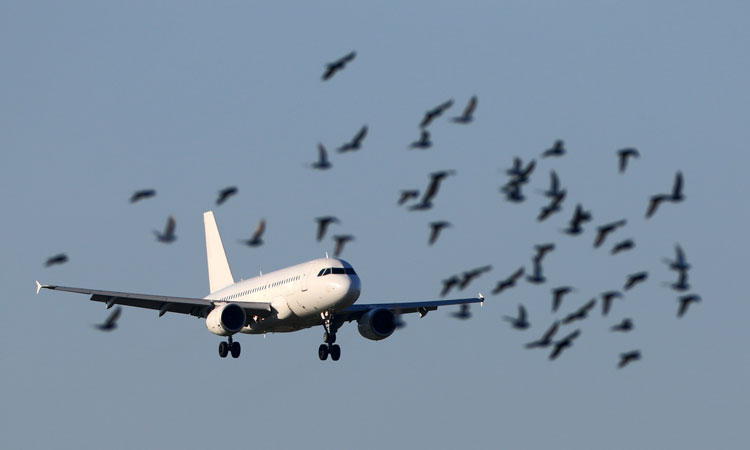
An airport could use a UAS to deter wildlife from the runway; increasing aircraft safety
What are the next steps in the aviation community (i.e. BVLOS, cargo delivery, surveying, scanning)?
Specific to steps with a focus on airports, the next steps are to continue the safe integration of UAS operation at airports and into the current management of air traffic. In parallel to this, the aviation community also needs to continue to educate the general public on the safe use of drones in all airspace, especially controlled airspace. While EIA and our partners’ advance the use of UAS at airports, it is important to ensure we utilise technologies that identify non-cooperative UAS incursions (airspace awareness) to help keep our passengers and clients safe.
Embracing this technology at EIA creates jobs, fosters innovation and technology growth and helps keep us at the leading edge of future aviation trends and technology. This is why EIA has been proud to partner with technology companies as part of the Alberta Aerospace and Technology Centre to advance UAS and related technologies, including the design and manufacture of UAS at EIA. AATC is also part of the effort to make the Edmonton Metropolitan Region into a Living Lab where technology and regulations can be advanced together.
In Canada, the UAS industry continues to move the yardsticks forward thanks to the innovation from companies like EIA’s partners, and by having a regulator willing to work with the industry to foster an environment where safe UAS operations can be conducted. Transport Canada has supported the continued advancement of the UAS industry’s capabilities through various trials and pilot projects, the results of which provide the regulator critical data needed to develop effective regulations. The critical next step for this industry is the ability to conduct routine BVLOS operations. In order to do so certain technologies, such as detect-and-avoid capabilities (whether airborne or ground based) will need to be proven to ensure the safety of other airspace users. Drone Delivery Canada is working towards these goals through the development of a Ground Based Sense and Avoid capability which will be used to ensure that their unmanned aircraft can be safely separated from traditional aircraft. The groundwork being laid for these types of operations will also foster future innovation such as the implementation of urban air mobility solutions.
Credit
Michael Zahra, President and CEO of Drone Delivery Canada
Jordan Cicoria, VP of Operations, Aerium Analytics
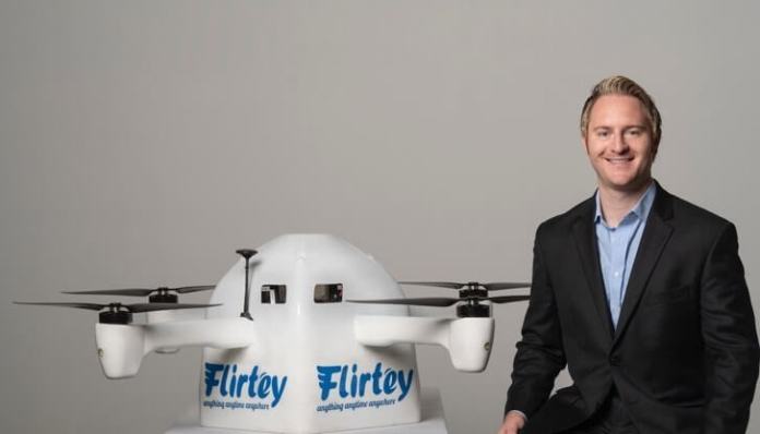
Flirtey, the industry-leading drone delivery service, announced today it has been granted a key patent that will enhance its fundamental technology with an additional component to safety in drone flights and deliveries. This granted patent will enhance safety when drone manufacturers implement technologies such as parachutes, while a drone is in flight and when it is delivering a package.
The patent recognizes the ability of a drone’s technology to detect an error in operation while the drone is in flight, ultimately deploying a safety mechanism, if necessary. This action further alleviates the risk of contact and/or injury to bystanders, while also sparing the unmanned aircraft.
Flirtey’s advanced drone delivery technology has unique capabilities unavailable from any other manufacturer. In addition to the startup’s industry-leading drone, the Flirtey Eagle, the Flirtey Portal is its sophisticated takeoff and landing platform, which enables scalable store-to-door operations. Lastly, Flirtey’s autonomous software platform enables drones to deliver safely with one Flirtey operator overseeing ten Flirtey delivery drones.
Flirtey’s ability to manufacture its aircraft from the ground up within its own facility has accelerated the safety, reliability and production of its technology.
Furthermore, Flirtey has built and patented a safety and anti-tampering system so that if someone pulled on the delivery tether, the tether has the ability to detach from the drone, ensuring safety.
Flirtey holds over 25 patents, granted and pending, in the United States and worldwide.
By Press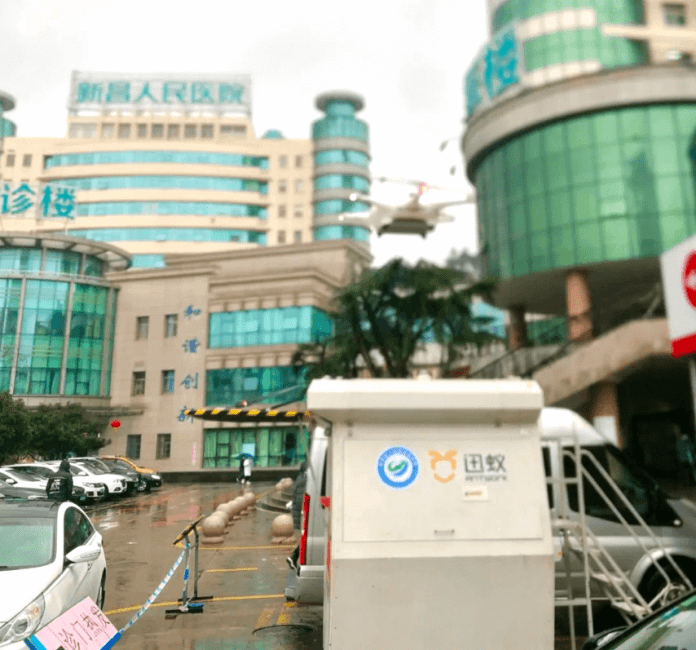
| Zhejiang – February 7, 2020 – 9:00 a.m. on February 6, an medical delivery drone flying from the people’s Hospital of Xinchang County to the disease control center of Xinchang County successfully completed the whole process of air transportation, marking the launch of the first “urban air transportation channel” to help to fight the corona virus (2019-nCoV) which is in a worrying outbreak in China. Xinchang County is located in Zhejiang province, and Zhejiang province is one of the most severe virus hit provinces with already 1006 patients confirmed 2019-nCoV diagnose as of Feb. 6th. At present, it is in a tense period of national epidemic prevention and control. In order to respond to the needs of epidemic prevention and control, Antwork actively contacts with local hospitals, supports epidemic prevention with practical actions, fully cooperates with local governments and medical-related units, and escorts the timely and rapid delivery of medical samples and protection materials through the deployment of it’s drone transportation network. During the epidemic prevention and control period, Antwork took the initiative to take drone RA3 and tr7s as well as unmanned station RH1 as the technical solution, to do the transportation of medical samples and quarantine materials between Xinchang County People’s Hospital, Xinchang County disease control center and Dashiju branch of Xinchang County People’s hospital. In this operation, the air delivery system provided by Antwork is adopted. Its automatic and unmanned operation mode can significantly reduce the contact opportunities between samples and personnel in the transportation process, and improve the delivery speed. At the same time, the Antwork branch company (Aerodeli), which undertakes this operation task, has obtained the world’s first urban drone delivery “license” issued by Civil Aviation Administration of China (CAAC) last October. The sample delivery work will be carried out in strict accordance with the certified operation procedures, which can ensure the safety of medical samples in the transportation process. |
| Take off and landing point of disease control center of Xinchang County |
| In the actual transportation process, the flight efficiency of drone has increased by more than 50% compared with the ordinary road transportation, which provides an efficient means of transportation for the epidemic prevention and control. At the same time, with more and more medical staff and ambulance being transferred to the front line, in the case of extreme personnel shortage, the use of drone transportation can also save human and material resources to the greatest extent. In addition, using drone to transport materials can effectively avoid secondary pollution of medical materials. As soon as the news of Wuhan blocking came out on January 23, Antwork immediately contacted the health and disease control departments of various regions, and took the initiative to petition for the technical support of drone air transportation for the front-line medical institutions fighting against the epidemic. After the project of Xinchang people’s hospital is put into operation, Antwork will also actively assist more medical institutions around the nation to deploy air transport services and contribute a technical force to the anti-epidemic! |
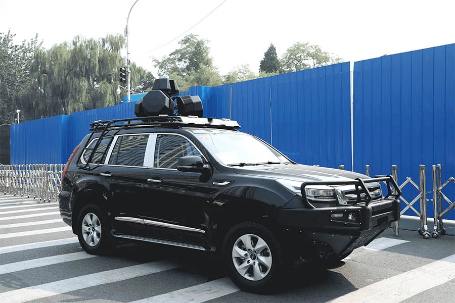
Dynamite Global Strategies (DGS), a provider of security and defense solutions, has announced the release of the V6000T, an advanced single-box multi-function electronic warfare (EW) system designed to protect military and VIP vehicle convoys from the threats posed by drones, as well as remote-controlled improvised explosive devices (RCIEDs).
The V6000T system provides 360-degree gapless full dome jamming coverage in order to defeat a large number of drones from up to 2km away. It also provides protection against RCIEDs and prevent remote radio detonation of improvised explosive devices (IEDs) by jamming all-known RCIED triggering frequencies across the RF spectrum of 20-6000MHz. V6000T is fully programmable, with each jamming module providing focused RCIED and drone jamming capability within a specific region of the RF spectrum.
V6000T has been developed in reponse to significant interest from DGS’ customer base, which includes military, law enforcement, homeland security agencies, defense contractors and VIP markets. The Department of Defense of a Western country has already placed an evaluation order for a small quantity of V6000T systems.
Daniel Chou, DGS CEO, stated: “We are excited to launch V6000T. Due to its state-of-the-art EW design of providing focused jamming capability against both RCIEDs and hostile drones simultaneously, we expect it to well support our customers’ effort to counter road-side bombs and those being delivered by hostile drones while traveling in a convoy”
By Mike Ball